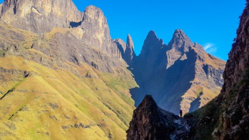
When you ascend Mnweni Pass, a striking grass gully can be seen on the opposite slopes, just West (left) of Pins Pass (Rock). This gully is not marked as a pass on the official maps but we decided to go check it out in December 2004. What we found was one of the most spectacular passes in the entire Berg and it's a route that should not be missed if you're an avid berg explorer! As we were probably the first people to do this pass (correct me if I'm wrong), there is obviously no path at all but the route-finding is fairly simple and the views are mind-blowing. You get a completely new perspective of the Mnweni Cutback and it's quite interesting to look at Mnweni Pass from the other side. There's a little grassy shoudler at about 2700m which offers the most impressive views - don't miss it!


Rating:
* * * * * (9/10)
Difficulty of the pass is rated from 1-10 (10 being very difficult, only to be attempted by the fit and experienced). A subjective quality rating is indicated by the number of stars (1 being low, 5 being the highest). Factors such as scenic beauty and overall experience come into play here, which may differ from person to person.

Access:
A full day (22 km) will be required to get to the base of Manxsome Pass from the Mnweni Cultural Centre. Follow the path all the way up the Mnweni valley to the base of Mnweni Pass where the route to Manxsome Pass continues up the Mnweni River.

Details:
The distance from the point where the path leaves the river to the top of Manxsome Pass is 1.4 km with an altitude gain of 860m.

Route:
Follow the Mnweni Pass path all the way to where it leaves the river off to the left. Stay in the river bed at this point and boulder-hop up past Pins Pass to your right. About 200m past the base of Pins Pass (at 2250m), a steep grassy ridge leaves the river on the Southern (left) slopes and heads straight up to Ukikicane. Ascend this steep grassy ridge for 50 vertical metres and then contour back into the Mnweni River at 2300m where a steep, broad, grassy gully leaves the Mnweni River up the Northern (right) slopes with a forest on its left-hand side. This is Manxsome Pass. Cross the Mnweni River just above a series of waterfalls and head straight up the pass. The gradient is initially VERY steep at about 60 degrees (watch for berg adders when pulling up on grass tufts). After about 50m, the gradient eases off slightly to a consistent 30-40 degrees all the way up to the top of the pass at 3160m. Stick to the right-hand side of the gully all the way up to avoid the forest and scree field and to make sure that you don't miss the viewpoint at 2700m! The pass ends at a tiny cairn which we built with a view over the Mnweni Pinnacles. Climb the short grassy slopes to the left to access the escarpment.

Finding the pass from the escarpment:
From the top of Pins Pass, keep a contour and head South along the edge of the escarpment, passing the Mnweni Pinnacles to your left. About 50m before you would be forced to descend to the Mnweni Cutback, a steep gully can be seen below you to the left, running parallel to your direction (South). This is Manxsome Pass. There is a small cairn on a rock at the top of the pass.
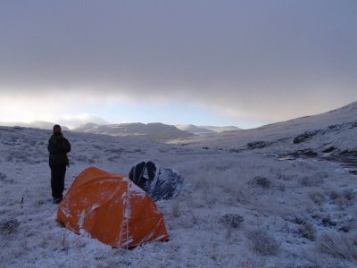
Overnight Spots:
There is a very good campsite at fork of the Rwanqua and Mnweni rivers about 4 km before the base of Mnweni Pass. There is also the option of camping at the secluded Chichi Bushcamp at the base of Pins Pass. There is a small (4 persons) cave in the cliffs on the left-hand side of the pass at about 3000m but it requires a tricky scramble to get to and is also quite far from water. Pins Cave is located in the Southern cliffs of Pins Pass, about 150 vertical metres down the pass. It has running water over its lip in summer but beware, there is hardly any wind protection offered by this cave and it's also rather small (4 persons).

Water:
The last water is at the point where the Mnweni River is crossed above the waterfalls to get into the pass itself. The next water is on the escarpment itself in the valley formed by the Mnweni Cutback, 1km from the top of the pass.


Forum Topic:

More info on Manxome Pass can be found on the forum here:

http://www.vertical-endeavour.com/forum/11-drakensberg-passes/1092-manxome-pass.html?limit=6&limitstart=0

Log in to comment


travissmcdonald's Avatar
travissmcdonald replied to: #77821 23 Jun 2022 22:30
Thanx for the replies. Ya if it was up to me I'd love to try the ridge but I'll go waterfall.we will start early to give newbies time to get up. Just very keen to climb it. A few years ago I did mweni and when I looked back at manxome I checked the map to see what it was called and couldn't believe it wasn't marked as one to climb. It's such a striking dramatic looking pass compared to others. So glad it's doable. Can't wait. Fangs was always my fav but might have a new one. Must give pins a try too. Looks hectic. 
ghaznavid's Avatar
ghaznavid replied to: #77818 23 Jun 2022 16:21
I came down Manxome Pass over the Heritage Day long weekend 2020 - definitely one of the best passes in the Drakensberg from a scenery perspective. After doing it, I demoted Pins from a 5* to a 4* and put Manxome Pass in its place as one of the 7 passes I rate 5*. Technically I could have both on the list, but I prefer to keep the list as short as possible.

I used the line on the GPX in the downloads section, which uses the lower waterfall bypass - which I found pretty straightforward, no harder than anything on many Drakensberg passes. As for a beginners route - they need to be very fit beginners, it isn't a trivial pass. The bit from the bottom of Mnweni to the gully is the hardest part, but generally the route is a wide grassy gully - which means the only complexity is overall fitness, nothing technical.

Not sure if I wrote it up on VE, but my writeup is at this link:
jonathantheghaznavid.wordpress.com/2020/10/02/mnweni-traverse-the-manxome-jabberwocky/
Riaang's Avatar
Riaang replied to: #77817 23 Jun 2022 12:13
I've done the ridge and as Supertramp says, it's STEEP.  But you get into the pass quickly.
There is this one section where you cross over the ridge into Manxome that is a bit dodgy. Not difficult, but you traverse around a rock with maybe a hikingshoe wide section of grass clinging for dear life unto the rock upon which you have to walk for about 2m. The drop-off is.........intimidating. My wife's been in Rolands and she found this short traverse more frightening. I stupidly relaxed just as I finished the traverse and stepped on a wet grassy patch which slid down about 40cm. That woke me up real quick!!!

So, if you don't mind heights then you could consider this section of the ridgehop. 

There is also the possibility that you can hop over the ridge a little bit higher up. When we ascended Manxcome I looked back and from the Manxome side and it looked like you could cross over between the saddle ( a bit higher up) and the lower spot I talked about above. I couldn't see what it looked like on the Pins side, but it looked like there is a bit of rock on the Pins side, but it wasn't too high, so there is a possibility that it can work. Next time I'm going up here I plan on checking it out, except if you want to investigate and post pics on VE
supertramp's Avatar
supertramp replied to: #77816 23 Jun 2022 11:55
Hi. I've only done the riverbed / waterfall alternative and found it quite easy. The higher approach looked a bit steep for my liking (personal view from below). Noted that it was in the month of Aug with the river level being quite low.

Enjoy Manxome, it is such a special pass!!! 
travissmcdonald's Avatar
travissmcdonald replied to: #77812 23 Jun 2022 07:34
Hi there. I want to try manxome next month. I have one or 2 first timers to the berg coming with. They will be fit enough but nervous about safety. Which is the safer route in ur opinion? The ridge between pins or around the waterfall?
Serious tribe's Avatar
Serious tribe replied to: #76180 06 Oct 2020 16:42
Ok, so I won't be unrolling my mat in this cave!
Riaang's Avatar
Riaang replied to: #76177 06 Oct 2020 11:18
This shelf in the top Manxome cave was quite level and large enough for my 2m frame. Still, for such a large cave the usable space was limited.

Nice view from here. Can you see the two Basuthos on the left of the image?


We went up in Dec, and boy it was a hot day. And yes, this pass just goes on forever! With no water even when you top out, unless you want to walk all the way into Lesotho and find water in a river to the NW. We opted to just walk around the cutback as we were overnighting in Ledges cave anyway.

Riaang's Avatar
Riaang replied to: #76176 06 Oct 2020 11:14
Last time I went up Manxome I found 3 caves, all on the left as you ascend (true right as you descend). I've posted all three below, starting at the bottom and then working my way up to the top one. Of the three, I would only rate the top one as "livable". Well, I don't even think I would fit into the first two caves, they are simply too small.

vivo101's Avatar
vivo101 replied to: #76175 06 Oct 2020 10:39
The cave with the scramble "Upper Manxome Cave" has very little usable floor space for such a large cave, due to the sloping and uneven front. Also looks like it can be damp in summer.
ghaznavid's Avatar
ghaznavid replied to: #76174 06 Oct 2020 09:52

Serious tribe wrote: Great pics Ghaz. Youa re getting your eye in.

Thanks.

Serious tribe wrote: What pack does your friend have?

Wild Craft 65L. I believe it was one he bought when he was in India.

Serious tribe wrote: Anyone got pics of inside Manxome Cave? Coords?

See Vivo's post above. Tony's post above also includes photos of the cave that is at ground level and doesn't require a climb to get to. If you download the GPS track under downloads, it includes a co-ord of the cave.
Serious tribe's Avatar
Serious tribe replied to: #76170 06 Oct 2020 09:20
Great pics Ghaz. Youa re getting your eye in.

What pack does your friend have?

Anyone got pics of inside Manxome Cave? Coords?
ghaznavid's Avatar
ghaznavid replied to: #76168 05 Oct 2020 19:59
After a very hard day 1, and bivvying near the top of Pins Pass, we decided to skip Manxome Pass, and take an easy stroll around the cutback. The problem was that we were both very low on water, and there would be no viable water for a while.

We decided to detour to the top of Manxome Pass to see if we could find ice to melt.

Standing at the top of the pass, we decided to head down Manxome, but then head up Mnweni Pass instead of Mnweni Buttress Pass.


Manxome Cave is fairly high up the pass, but neither of us attempted to head to it. The scramble to it looks fairly committed, and getting back down would be a pain.


The top of the pass is a fairly gentle grass gully, that never actually gets that steep. It would be fairly painful to go up, but it is rather pleasant to descend. There is actually a trail developing, at least for the top quarter of the pass.


Naturally we stopped at the famous balcony for a short break, but with practically no water left, this was a short stop.


The views were great, although the smoke did obscure them at times.


The lower section of the gully got a bit overgrown. We picked a line that avoided this, and followed the gully right down to the river. We knew we had to break left to avoid the waterfalls, but decided to go for a break on the river first, mostly because we were both our of water by now.


After a nice long break, plenty to drink and a bit of a wash in the river, we went a short distance back up the grassy slope and traversed around to the ridge we would follow to get back down to the river below the waterfalls. This section was by far the hardest part of the pass, although it was just steep - would be hard ascending, but not bad going down.


We made our way down to the river, where we found a surprisingly good trail, which connected to Mnweni Pass just below 2200m - and upon reaching Mnweni Pass, we joyfully chortled "Callooh! Callay!". We proceeded from there up Mnweni Pass to Nguza Cave.

Overall Manxome Pass gets a rare 5* quality rating from me - I rate less than 7% of the passes I have done as 5 star passes, and this is definitely worthy of this title. For reference, the other passes I currently rate 5* are Cockade (kind of want to rate it 6 out of 5), Ifidi, Xeni, Camel, Organ Pipes, Leslies and Mashai.

As for difficulty, descending it is actually not bad at all. Going up would probably be fairly hard, as it is a long sustained pass. It's primary quality is a great view on good stable terrain.

Fun anecdotal side-note: the name of this pass is the origin of an interest that has resulted in people who spend considerable amounts of time with me being occasionally subjected to random Lewis Carol poetry. Notably including How Doth the Little Crocodile, You are old Father William, The Mouse's Tale, and obviously Jabberwocky.
vivo101's Avatar
vivo101 replied to: #75026 13 May 2019 13:04
Here is some more pictures of the caves in Manxome pass from my recent trip. There are four caves in the main pass.

The biggest being approximately 300m from the pass summit has a low grade scramble to get into (nothing worse than the first scramble on the NHA into Corner). It will only sleep maximum 5 people, the floor is very slanted and sleeping space is minimal. The cave has been used before, note the stacked stone "wall". 


Approximateley 200m below the bigger cave is a overhang and below that a small cave that will fit 3 people.


The fourth cave is situated high above the overhang cave and I could not see a possible route into it without the use of ropes.


All these caves are situated on the lefthand wall while heading up the pass and above the halfway mark of the pass. The absence of flowing water anywhere nearby makes them quite difficult to use as a overnight stop, unless you want to haul a extra 2-3kg up Manxome.........
   
ghaznavid's Avatar
ghaznavid replied to: #65247 30 Sep 2015 10:38

tonymarshall wrote: Congratulations are in order; two more people have reached the noteworthy milestone of doing all the official Mnweni Passes (I was along on many of the passes with them) on this hike - well done elinda and Thora. :thumbsup:


Impressive work ladies! Well done Elaine and Thora!
tonymarshall's Avatar
tonymarshall replied to: #65220 29 Sep 2015 07:42
Thanks for the photos and write up Richard and elinda, I'm really pleased you guys had a great hike doing these two passes.

Congratulations are in order; two more people have reached the noteworthy milestone of doing all the official Mnweni Passes (I was along on many of the passes with them) on this hike - well done elinda and Thora. :thumbsup:
elinda's Avatar
elinda replied to: #65207 28 Sep 2015 18:43
Thanks @firepish... we wondered whether we would see you guys going up Mnweni but the entire pass was in shadow from our vantage point on Manxsome so saw nothing! Yes, that descent was pretty rough - I have holes on the back of my pants to prove it!! :silly:
firephish's Avatar
firephish replied to: #65206 28 Sep 2015 17:40
nice write up, we were going up Mnweni and saw you guys descending that steep ridge to the waterfall prior to going up manxome ... looked pretty hairy from where we were :eek:
elinda's Avatar
elinda replied to: #65205 28 Sep 2015 16:05
7 of us (myself, Richard, Greg, Irene, Mark, Thora and Craig) set out to conquer this pass over the long weekend in September. Manxsome Pass is a very prominent steep grassy slope that is visible when ascending Mnweni Pass – not that I ever noticed it on my previous hikes up Mnweni as both of these occurred in thick mist with limited visibility. So when I saw photos and write ups of previous ascents, I was keen to give this one a go. We felt that Stijns river entry route was more within our capabilities and were not brave enough to tackle the knife edge route which is the alternative option

Day one – MCC – Chi Chi Bush camp

The forecast was for hot, sunny weather and so it was for the entire 4 days of the hike. Perfect weather for hiking but In fact, perhaps a bit too hot………. I was suffering the beginnings of heatstroke by the time we reached the Mnweni River just below Shepherds Cave at lunchtime, feeling nauseous and zero energy. I rested, drank plenty of water, downed some Ensure and managed to plod the remaining 4kms or so to Chi Chi. We enjoyed a beautiful warm evening surrounded by the mountains.

Day two – Manxsome Pass to tenting spot near Rwanqa Pass

We were on our way by 7.00am and after a bit of boulder hopping and bushwhacking past the entrance to Pins Pass found ourselves at the bottom of the ridge that rises directly in front of you towards the Ukikicane. This is exactly as Stijn describes it. I had been a bit concerned that this would be tricky to ascend as there had been reports that the area had been burnt over previous weeks. This turned out to be exactly the case and we found the climb difficult as the ground was loose and crumbly with not much to hold on to. The ridge is a lot steeper than it looks when viewed from below! We then had to contour and descend to the right, aiming to cross the river above the waterfall. This was also very steep and a tumble here could land you in big trouble. We took a break at the waterfall before starting the climb proper up Manxsome. It is a very steep climb which does not relent the entire way. The views are nothing short of spectacular and the view point at 2700m which straddles Manxsome and Pins Passes is pretty mind-blowing. From here it is more steep plodding and we eventually topped out at 12.30pm. This is an incredible pass that is long and sustained but nothing technical and totally worth doing. In my opinion the most difficult part is accessing it at the bottom.
We headed north to our campsite at Rwanqa and found water eventually at the river in the valley about 300 metres west of the top of the pass. This was the first time I have experienced warm weather on top of the escarpment and later that afternoon the skies darkened dramatically and we had lightning and thunder, but not much rain

Day three and four – Rwanqa Pass and overnight at 5 Star Cave

We again had an early start and were soon making our way down Rwanqa pass. There is no path and it is very steep, rocky and rough. We kept to the true right of the river and high on the slopes, traversing around and over rock bands with magnificent views of the Black and Tan wall towering above us. We basically followed Tony Marshall’s route from his write up (but in reverse) Again there were areas that had been burnt, which made the going slow and tricky. We eventually reached the grassy ridge (very steep) that runs down directly from the Black and Tan wall and descended/contoured this all the way to the river at the bottom. This ridge had not been burnt and the grass was thick and fairly long, so although this made it easier it was not kind to the feet and ankles. There is a lot of sharp pointy vegetation at the bottom and it was with some relief that we reached the river and stopped for some well-earned lunch. Richard had spotted a path running along the right hand bank (true right) from the top of the ridge, so we climbed out the river and soon located the path. This was easier for us to find as the grass was not long and had been burnt recently. This entire route had fields of Scilla Natalensis blooming and it was quite an experience to be walking through these beautiful blue flowers. From here it was easy walking all the way to the head of the valley and the Mnweni River. We saw quite a few dagga fields on the way, which would explain the well-used path. When passing Shepherds Cave we could see there were smugglers living in it with obvious evidence of newly planted dagga fields directly in front of the cave and even right next to the path. We continued to 5 Star Cave where we spent a relaxing afternoon and evening before the walk out the following day.

Thanks to Stijn and Tony Marshall for advice and information on these passes – much appreciated!

Another memorable hike back in the beautiful Mnweni with Manxsome Pass the absolute star of the show!
Richard Hunt's Avatar
Richard Hunt replied to: #65203 28 Sep 2015 14:36
Following the previous link to my photos of Manxome Pass here is also a video taken from a view point.
goo.gl/photos/JHjXnyxRRMru8JGh9
Richard Hunt's Avatar
Richard Hunt replied to: #65202 28 Sep 2015 14:19
Hi Guys. A group of us ascended Manxome Pass at Mnweni this last week end. It was the most scenic pass that I have ever done. Elinda will soon post a detailed write up of this pass and also Rwanqa Pass which we went down. For tasters I have attached a link to my photos of Manxome Pass and soon also a link to photos of Rwanqa Pass. We took the route/approach that Stijn mentioned in 2004 and not the hair raising route/approach that Tony/Chris took recently. It looks like there can be an easier 3rd approach which we saw but needs to be investigated first. Enjoy...... goo.gl/photos/GJoCXVjLgyWjvXHN9
ghaznavid's Avatar
ghaznavid replied to: #59192 07 Dec 2013 09:26
Looking back over this old thread and my pics of the pass from Mnweni - does look like a pretty cool pass.


And that big buttress behind it is the home of the khulu "Pins Buttress" (a few hundred metres behind the escarpment edge).

Ps. for the record, apparently the word "Manxome" is a hybrid of the words "Manly" and "Fearsome".
ghaznavid's Avatar
ghaznavid replied to: #4352 13 Oct 2011 18:02
If there are two caves on Manxome pass, why on earth would people choose to name them things like Manxome Cave, what about Bandersnatch Cave, or Red Queen Cave...
tiska's Avatar
tiska replied to: #4342 13 Oct 2011 11:03
Many thanks for all the details. The photos make for a really nice description of the pass.
tiska's Avatar
tiska replied to: #4331 12 Oct 2011 20:12
Off topic I know, though only by a couple of pases - how was Ranqwa pass Tony? Did you check out the cave on the way up on the left? Any signs of anyone else using Ranqwa? And how bad was the bush lower down the pass?

Did you see any traffic on the big path that runs near the escarpment between Ranqwa and Rockeries?
tonymarshall's Avatar
tonymarshall replied to: #4329 12 Oct 2011 17:44
In June when I did Rwanqa Pass, we camped overnight on the summit beneath the Black and Tan Wall and the lights of the mine were clearly visible in the distance. A lot of lights over quite a big area, and quite a surprise intrusion of civilisation at the top of the 'Berg.