
- Forum
- Drakensberg Forum
- Drakensberg Hiking
- AmaNgwane (Mnweni & other areas)
- Mnweni Pass - Rockeries Pass Loop
Mnweni Pass - Rockeries Pass Loop
22 Jul 2010 19:25 #1492
by anthony
Mnweni Pass - Rockeries Pass Loop was created by anthony
I would like to do this walk over the next long weekend and would like to know if it a it can be done over 2 nights and 3 days.
We want to leave the cultural center on sat morning and make it up rockeries, then descend Mweni on Sunday and hike out the last bit back to the cultural center on Monday morning.
-How long does it take to get to the top rockeries.
-Is it easy to find your way in the area to the pass, or is navigation a bit of a challenge in the tribal lands.
-Is there sufficient water along the route and on top of the escarpment,or any long distances where there is no water.
-Are there any tricky sections on either of the passes.
Any other important info or suggestions would be appreciated, as I hike with my two boys aged 12 and 14, and would not like to put them in an unnecessary situation.
Please Log in or Create an account to join the conversation.

22 Jul 2010 21:50 #1493
by bigberg
Replied by bigberg on topic Mnweni Pass - Rockeries Pass Loop
its a great route to do. and easily done in 3 days.its around 5o km and when u consider trail runners are doing it in 6 hours, a bit of fitness you guys do it with ease
i have only done it the opposite way round 1st night sleeping near the base of mweni pass 2nd in ledgers cave ( a must see ) and 3rd day down.
there is loads of water to be found so no problem there.
the mweni area and its paths that lead off to knowhere can be a problem. the first 5 kms i always get a bit lost there. but with a up to date map, gps and a little linger between the locals goes a long way.
other wise just adore the area one of the bergs finest
Please Log in or Create an account to join the conversation.

23 Jul 2010 08:08 #1494
by Stijn
Replied by Stijn on topic Mnweni Pass - Rockeries Pass Loop
3-days is the standard length for this trip but I would recommend doing it the other way around for 3 reasons:
- By going up the long way via Mnweni Pass, you break the climb up into 2 days.
- Rockeries is definitely the more pleasant of the two passes to descend. Going down Mnweni must be hard on the knees. The trail also quite loose and steep.
- Navigating your way up the Mnweni valley is much easier than the Rockeries valley. Coming down Rockeries pass, all paths eventually lead to the road but it would be quite tricky finding the right path on your way up, never having been there before.
As for navigating through the tribal areas in general, use your map for the lie-of-the-land and take the paths on it with a pinch of salt. Make sure you are always heading up the correct valley and there will be plenty of local paths and/or cattle tracks going in the direction you wish to go.
Awesome route this - enjoy!
Please Log in or Create an account to join the conversation.

23 Jul 2010 09:27 - 23 Jul 2010 11:04 #1496
by mike
Replied by mike on topic Mnweni Pass - Rockeries Pass Loop
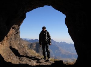
It is a very awesome hike, I to have only done it ascending Mnweni and descending Rockeries. Somehow never manage to find the same route up to the Mnweni pass tho. If you do choose to go up Mnweni there is good camping near sheppards cave,as it splits off for Fangs pass. If you can manage to go a bit further on the first day the Chi-chi bushcamp makes for an even better campsite as you are surrounded by cliff and have a nice view into the valley below!
The two caves on top are really nice to sleep in with great views!
I will more than likely be doing the same route over the public holiday with my brother and nephews
The two caves on top are really nice to sleep in with great views!
I will more than likely be doing the same route over the public holiday with my brother and nephews
Last edit: 23 Jul 2010 11:04 by mike.
Please Log in or Create an account to join the conversation.
23 Jul 2010 09:54 #1498
by Sasquatch
Replied by Sasquatch on topic Mnweni Pass - Rockeries Pass Loop
I would echo what has already been said, however it is definitely worth spending a night in Mponjwane cave once you're on the escarpment, the views of the Mnweni cutback are breathtaking! If you decide to overnight near Mponjwane, I would suggest getting water beforehand from the smallish stream which is pretty much halfway between the heads of the passes (Mnweni and Rockeries), as water near the cave is scarce. Enjoy!
Please Log in or Create an account to join the conversation.

23 Jul 2010 09:59 #1499
by SeriousTribe2
Replied by SeriousTribe2 on topic Mnweni Pass - Rockeries Pass Loop
@Anthony
Agree with Stijn on this one.
Just maintain your heading up the right valleys towards Mweni. The paths split numerous times so maintain a bearing to general direction.
If you are unable to gain the pass on the first day the valley below mweni is pleasant, and well watered for camping.
Evidence of isolated deliberately)dagga fields are everywhere.
No water up Mweni, but on topping out there is a well running river.
Rockeries is easier to descend than Mweni would be.
Neither are technically difficult. There is an interesting rocky descent into the river at the base of Rockeries.
Please be aware of the fact that Rockeries is a major dagga route, as is the path out into the inhabited areas. It is about 2m wide in some places due to the donkey trains, so you won't miss it.
It is far easier to find your way outon the rockeries route than it would be to find your way in.
The locals are pleasant, and so is the tourist centre.
The kids will freely tell you that dagga grows in the patches.
An awesome area. If you haven't before, then you need to visit the Mighty Mponjwane. An awesome block of rock indeed!
Please Log in or Create an account to join the conversation.
- SeriousTribe2
-

- Offline
- Elite Member
-

Less
More
- Posts: 211
- Thank you received: 25
23 Jul 2010 17:36 #1501
by anthony
Replied by anthony on topic Mnweni Pass - Rockeries Pass Loop
Thanks for all the helpful info,i was maybe thinking of taking an extra day and then going up Ntonjelana pass,but not sure if the views will be as good as Rockeries.I also inquired at the center, and it is possible to organise transport up to Rockeries which cuts off 5km,has anybody done this before.
Please Log in or Create an account to join the conversation.
25 Jul 2010 15:00 - 24 Nov 2013 13:59 #1504
by Sterkhorn
Replied by Sterkhorn on topic Mnweni Pass - Rockeries Pass Loop
Hi Anthony
This is a previous post from Intrepid on the transport issue:
www.vertical-endeavour.com/forum/8-drakensberg-hiking/1353-mini-traverse.html#1360
I recently did the trip up Rockeries and down Mnweni and have previously done it up Mnweni and down Rockeries. Both routes are special. I particularly enjoyed the splendour of the Rockeries as you ascend and the opportunity to enjoy the view over the cutback as you descend Mnweni.
I found little problem in finding the route in on the Rockeries route and no problem descending Mnweni (actually quite enjoyed it).
As you are probably aware, the Mnweni route is a lot longer and lends itself to an overnight break before ascending. The Rockeries route is also quite long and we preferred a break at the base too, but if you use the option of transport over the first section, I'm sure it will reduce that pressure significantly.
If you do decide to take the "Rockeries up and Mnweni down" route, another very interesting feature worth investigating is the Mnweni Pools - similar, but larger than Marble Baths in Injesthi.
Normally, just after Shepherd's cave, you cross the Mbundini river and take the path on the right over the Mnweni river (U12 junction) and hike below Dassie ridge towards the MCC. Instead of taking the U12 route to the right, carry on straight down for about another 1.5 km and at the U11 junction, cross the Mnweni river and soon after the confluence of the Mnweni and Icidi rivers you will come across the Pools (you could also keep to the left bank of the Mnweni river till the confluence). It is in comfortable reach from the top of Mnweni pass and if you camp there, it provides a shorter trip for your last day to the MCC. You would then take the U11 to U10 route to tie up with the normal route back.
Mnweni Pools photos:
www.vertical-endeavour.com/gallery/drakensberg/308-mnweni-pools.html
www.vertical-endeavour.com/gallery/drakensberg/309-mnweni-pools.html
www.vertical-endeavour.com/gallery/drakensberg/310-mnweni-pools.html
Last edit: 24 Nov 2013 13:59 by intrepid. Reason: Fixed broken image links
Please Log in or Create an account to join the conversation.

26 Jul 2010 08:50 - 26 Jul 2010 08:54 #1505
by intrepid
Take nothing but litter, leave nothing but a cleaner Drakensberg.
Replied by intrepid on topic Mnweni Pass - Rockeries Pass Loop
Great input given here guys, thanks to all!
Yep, get local transportation if you can (try arrange it beforehand, else it gets more difficult to arrange). You can get dropped off (and even picked up - make out a rough time and get the driver's cell number) roughly 5km along either valley. Do inquire where exactly the driver intends to drop you off, and work out a price before you get in. Sometimes the road washes away, or they don't feel like going right to the end.
@Sterkhorn - those pools are great, aren't they? You can also get there from the "normal" trail at Mlambu's kraal, junction U10, if you follow a small track heading along the river, not far from there. Just as a side note, there are some spectacular pools in the Icidi River near U9 too - lovely sandstone/marble effect, pools and chutes (Marble Baths will always be a classic, but these are actually much bigger and more spectacular IMHO).
@SeriousTribe2: that interesting rocky bit at the base of Rockeries is apparently man-made. It's an attempt to stop the donkey carrying the dagga down further. Except now they simply offload the donkeys there and switch to other donkeys on the other side (operated by locals working with the Basotho).
Yep, get local transportation if you can (try arrange it beforehand, else it gets more difficult to arrange). You can get dropped off (and even picked up - make out a rough time and get the driver's cell number) roughly 5km along either valley. Do inquire where exactly the driver intends to drop you off, and work out a price before you get in. Sometimes the road washes away, or they don't feel like going right to the end.
@Sterkhorn - those pools are great, aren't they?
You can also get there from the "normal" trail at Mlambu's kraal, junction U10, if you follow a small track heading along the river, not far from there. Just as a side note, there are some spectacular pools in the Icidi River near U9 too - lovely sandstone/marble effect, pools and chutes (Marble Baths will always be a classic, but these are actually much bigger and more spectacular IMHO).@SeriousTribe2: that interesting rocky bit at the base of Rockeries is apparently man-made. It's an attempt to stop the donkey carrying the dagga down further. Except now they simply offload the donkeys there and switch to other donkeys on the other side (operated by locals working with the Basotho).
Take nothing but litter, leave nothing but a cleaner Drakensberg.
Last edit: 26 Jul 2010 08:54 by intrepid. Reason: typo
Please Log in or Create an account to join the conversation.

01 Aug 2010 15:38 - 03 Aug 2010 02:47 #1534
by Serious tribe
Replied by Serious tribe on topic Mnweni Pass - Rockeries Pass Loop
Definitely second ST2. You have to stay at Mponjwane Cave and do some photography in the area, the tower opp the cave is amazing. It is huge, and close enough to the cave that you get quite an interesting perspective of it.
If you have the time, 5/6 days for up Rockeries down Mweni and up Manxome and down Fangs would be an absolutely amazing tour de force, not to mention, a photographic feast.
If you have the time, 5/6 days for up Rockeries down Mweni and up Manxome and down Fangs would be an absolutely amazing tour de force, not to mention, a photographic feast.
Last edit: 03 Aug 2010 02:47 by Serious tribe. Reason: jabberwocky to manxome
Please Log in or Create an account to join the conversation.
- Serious tribe
-

- Offline
- Platinum Member
-

Less
More
- Posts: 921
- Thank you received: 460
