
Elandshoek Pass
24 Jul 2018 12:55 #73714
by Riaang
Replied by Riaang on topic Elandshoek pass
Hi All,
We're planning on exploring the area around Giants Castle a bit this weekend. While looking at possible route variations my eye caught Elandshoek pass. Anyone been down it lately? And the contour path, how does it look?
It is definitely a bit further than any of the regular passes a bit to the north, but it is there, so I should attempt it some time or another")
We're planning on exploring the area around Giants Castle a bit this weekend. While looking at possible route variations my eye caught Elandshoek pass. Anyone been down it lately? And the contour path, how does it look?
It is definitely a bit further than any of the regular passes a bit to the north, but it is there, so I should attempt it some time or another
Please Log in or Create an account to join the conversation.

24 Jul 2018 15:38 #73723
by ghaznavid
Replied by ghaznavid on topic Elandshoek pass
Please post how it goes - I am leading a hike that will be coming down that way in 2 weeks time.
Please Log in or Create an account to join the conversation.

25 Jul 2018 08:24 #73727
by AndrewP
Replied by AndrewP on topic Elandshoek pass
I went up Elandshoek Pass a year ago.
It is really easy to find the top of the pass. Just get onto the highway cutting along the flat ground at south side of Giants.
The path is pretty easy to follow on pass itself. Once it flattens out a bit, look out for a feint trail breaking out left and heading towards the obvious saddle.
The contour path is sort of there, but you will not really get lost if not on it.
If you have a garmin, my map has the pass on it. If not, any osm based map will also work.
Please Log in or Create an account to join the conversation.
25 Jul 2018 14:57 #73731
by Riaang
Replied by Riaang on topic Elandshoek pass
Cool, thanks Andrew. Got your map (works great!), plotted the route as a descent option
I'm taking a newbie along on this hike, and I promised my brother in law an easy hike for once, so depending on how the group feels on Sunday morning and how early I can get them out of their sleeping bags will determine our route back to Giants castle camp.
Last question - how is the water situation around Giants hut currently.
Please Log in or Create an account to join the conversation.
26 Jul 2018 07:21 - 26 Jul 2018 07:38 #73733
by tonymarshall
Replied by tonymarshall on topic Elandshoek pass
On the Easter long weekend 2017, elinda, Richard Hunt, Thora,Papa Dragon, Single Speed and tonymarshall did a circuit at Lotheni, ascending
Elandshoek Pass and descending Lotheni Pass.
On the first day we ascended Taylor’s Pass from Lotheni Office, tenting between thetop of Taylor’s Pass and the base of Elandshoek Pass below the ridge of The Sisters peaks. In the late afternoon Single Speed and I went to the top of the South Sister peak, and had this view of the route of the path contouring around the lower slopes of South Ridge to the base of Elandshoek Pass.
The path is difficult to make out in the photo above, so zoomingin the same photo, the path can be seen crossing in out of the foreground
ridges and valleys in the photo below.
The next morning was overcast and misty, so we were fortunate wehad had this view the previous afternoon. We headed up the slope from our
campsite, soon finding the path again, and commencing our traverse in and out around the ridges and valleys.
We had received some information that there were two pathsapproaching Elandshoek Pass along South Ridge, and that it was better to use
the upper one, so we were keeping a lookout for the split in the paths, which was difficult to spot. The entire group missed the split, but we fortunately
saw the upper path above us before we were too far past the split, and went back and got onto the upper path. Although generally the path generally contoured, it got quitesteep at some of the stream crossings, which became quite slippery in the damp and mud.
After contouring for what seemed like forever, we reached thegully/stream at the base of Elandshoek Pass. An awkward rock ledge has to be
negotiated to get into the gully.
Soon after entering the gully from the right (true left), thepath crosses to the left (true right), and continues to the top of the pass on
the true right.
Please login or register to view the images attached to this post.
Last edit: 26 Jul 2018 07:38 by tonymarshall.
Please Log in or Create an account to join the conversation.
- tonymarshall
-

- Offline
- VE Advisory
-

Less
More
- Posts: 770
- Thank you received: 2244
26 Jul 2018 07:34 - 26 Jul 2018 07:45 #73734
by tonymarshall
Replied by tonymarshall on topic Elandshoek pass
By late morning we had ascended above the level of the mist.
For the first time we could see what lay ahead.
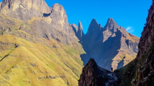
The cliffs of South Ridge protruding out of the mist was an impressive sight, and we frequently stopped to admire the view and take photos.
A view back down Elandshoek Pass
There were a few rock bands to scramble through, but none of the scrambles were difficult and with the good trail the whole way navigation was
easy.
We had a quick lunch near the top of the pass, where there was still water in the stream not far below the path. Looking up the pass, it
appeared as if we were heading into a dead end, surrounded by cliffs.
Right at the top, a narrow grass ledge to the left appears, and this is the final stretch to the top of Elandshoek Pass.
The group at the top of Elandshoek Pass, fltr Single Speed, Papa Dragon, Thora, Elinda, Richard and Tony.
The view south from near the top of Elandshoek Pass. The highpoint on the left horizon is Redi, and at the centre of the photo below The
Hawk and The Tent are behind the mist, with Lotheni Pass in the cutback where the mist extends furthest to the right.
That night we tented close to the summit of Giant’s Castle, on a small levelish spot with an awesome view of the escarpment to the north, and
the next day we descended Lotheni Pass.
For the first time we could see what lay ahead.
The cliffs of South Ridge protruding out of the mist was an impressive sight, and we frequently stopped to admire the view and take photos.
A view back down Elandshoek Pass
There were a few rock bands to scramble through, but none of the scrambles were difficult and with the good trail the whole way navigation was
easy.
We had a quick lunch near the top of the pass, where there was still water in the stream not far below the path. Looking up the pass, it
appeared as if we were heading into a dead end, surrounded by cliffs.
Right at the top, a narrow grass ledge to the left appears, and this is the final stretch to the top of Elandshoek Pass.
The group at the top of Elandshoek Pass, fltr Single Speed, Papa Dragon, Thora, Elinda, Richard and Tony.
The view south from near the top of Elandshoek Pass. The highpoint on the left horizon is Redi, and at the centre of the photo below The
Hawk and The Tent are behind the mist, with Lotheni Pass in the cutback where the mist extends furthest to the right.
That night we tented close to the summit of Giant’s Castle, on a small levelish spot with an awesome view of the escarpment to the north, and
the next day we descended Lotheni Pass.
Please login or register to view the images attached to this post.
Last edit: 26 Jul 2018 07:45 by tonymarshall.
The following user(s) said Thank You: elinda, JonWells, ghaznavid, Richard Hunt, Riaang, Andreas, SingleSpeed
Please Log in or Create an account to join the conversation.
- tonymarshall
-
- Offline
- VE Advisory
-
Less
More
- Posts: 770
- Thank you received: 2244
23 Mar 2020 09:53 - 23 Mar 2020 09:54 #75785
by AnoukBaars
Replied by AnoukBaars on topic Elandshoek Pass
Just did this pass last weekend, and it was beautiful. the path is easy to follow- last part is steep- at the escarpment rock wall there is some possibilities to protect yourself in case of bad weather ( overhangs) . There is a short cut from the contour path that you could take that cuts out about 3 km of the bottom of Elandshoek pass-. you can see it ahead of you when you go up via Oribi ridge. we went up from where the contour path/ top of Taylor pass / split to the start of the Elandhoek path.
GPX track on my strava account,
GPX track on my strava account,
Please login or register to view the images attached to this post.
Last edit: 23 Mar 2020 09:54 by AnoukBaars.
The following user(s) said Thank You: Serious tribe, diverian, elinda, Stijn, firephish, Smurfatefrog, tonymarshall, Iano2
Please Log in or Create an account to join the conversation.
- AnoukBaars
-
- Offline
- New Member
-

Less
More
- Posts: 6
- Thank you received: 20
23 Mar 2020 10:36 #75786
by Riaang
Replied by Riaang on topic Elandshoek Pass
Cool, thanks for the pics. That footpath between the sisters is clearly visible in your pic.
This pass has now eluded me twice already. Something needs to be done about it!
This pass has now eluded me twice already. Something needs to be done about it!
Please Log in or Create an account to join the conversation.
13 Aug 2022 22:44 - 14 Aug 2022 00:15 #77940
by supertramp
Replied by supertramp on topic Elandshoek Pass
Elandshoek Pass 1/3
Over the long weekend in August, our group of 4 (Supertramp, Pathfinder, HAC and Vestibule) tackled a 4 pass adventure in the Giant's Castle area. Day 1 was a one day summit of Judges Pass, camping on the escarpment, just north of the summit of Bannerman's pass. Day 2 we descended Langies, contoured around and camped next to Giants Hut. Day 3 we made our way over the Gable shortcut, ascended Elandshoek pass and slept in Giants Cave (the one located on the eastern side of the gully). On Day 4 we made our way down Giants Pass and Giants Ridge back to the start.
This write-up, will attempt to cover some extra info on Elandshoek pass, including, what I believe is coined the "Gable shortcut". The shortcut allows you to cut directly over the ridge and saves you from having to contour around the Sisters (approximately 7km in distance - blue section in image below). The shortcut is the section in orange.
Approaching the shortcut on the contour path from the north (from Oribi Ridge / Giants Hut), the path continues to the east before cutting back sharply and then heading towards the saddle. This adds another 1.5km which just feels a bit wrong. We decided to head straight up from the contour path at a point almost directly across from the saddle.
Looking at the image below (taken just before reaching the saddle, looking down and to the north), the red line indicates our chosen route, with the blue line indicating a portion of the additional 1.5km section as it loops back up with the saddle.
This was our first ascend of Elandshoek pass, having descended it twice before over the course of the previous 1.5 years. If I was forced to choose, I would definitely recommend going up, especially if one intends to use the shortcut. There is a short section, on the northern slopes of the ridge that requires some scrambling. Nothing crazy, just very steep and quite eroded, much easier going up, than down.
A closer look at the scramble section, much steeper than it appears on the image.
Once reaching the saddle, you are rewarded with this majestic site, offering views over the entire Lotheni area and back to Elandshoek pass. We took a few minutes to take it all in
Please login or register to view the images attached to this post.
Last edit: 14 Aug 2022 00:15 by supertramp.
Please Log in or Create an account to join the conversation.
- supertramp
-
- Offline
- Elite Member
-

Less
More
- Posts: 227
- Thank you received: 464
13 Aug 2022 23:48 - 14 Aug 2022 00:16 #77941
by supertramp
Replied by supertramp on topic Elandshoek Pass
Elandshoek Pass 2/3
After the saddle, one gradually drops about 70m in elevation over 1.2km before joining up with the main path that heads to Elandshoek pass (or Lotheni to the south).
The image below is just after the junction with the main path, looking back towards the shortcut
This section of contour path as you approach the pass, does feel like it lasts forever, but the stunning views keeps one engaged all the time
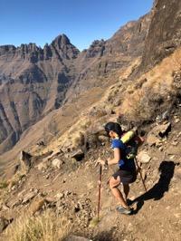
There is however one steep scramble section on this piece of contour path, about 1km before entering the pass proper. Quite eroded, but more than enough grass holds to easily make your way up (or down).
Approach to gully
On reaching the gully, it appears quite intimidating at first, but there is a clear path to the left (true right), as indicated on the previous posts in this thread
There are 2 separate scrambles on this section going up the left hand side of the gully (as mentioned on the thread) but we managed them all quite easily (same experiencing when going down before). The path disappears the last section before reaching the top but one can't really go wrong from here. Just head straight up until you reach the rock wall, and you will be met with a nice broad ledge that leads you around the corner and onto the escarpment
View down the pass, from about 95% up
After the saddle, one gradually drops about 70m in elevation over 1.2km before joining up with the main path that heads to Elandshoek pass (or Lotheni to the south).
The image below is just after the junction with the main path, looking back towards the shortcut
This section of contour path as you approach the pass, does feel like it lasts forever, but the stunning views keeps one engaged all the time
There is however one steep scramble section on this piece of contour path, about 1km before entering the pass proper. Quite eroded, but more than enough grass holds to easily make your way up (or down).
Approach to gully
On reaching the gully, it appears quite intimidating at first, but there is a clear path to the left (true right), as indicated on the previous posts in this thread
There are 2 separate scrambles on this section going up the left hand side of the gully (as mentioned on the thread) but we managed them all quite easily (same experiencing when going down before). The path disappears the last section before reaching the top but one can't really go wrong from here. Just head straight up until you reach the rock wall, and you will be met with a nice broad ledge that leads you around the corner and onto the escarpment
View down the pass, from about 95% up
Please login or register to view the images attached to this post.
Last edit: 14 Aug 2022 00:16 by supertramp.
The following user(s) said Thank You: elinda, jamcligeo, DeonS, tiska, firephish, Riaang, GriffBaker, Carl Gebhard
Please Log in or Create an account to join the conversation.
- supertramp
-
- Offline
- Elite Member
-
Less
More
- Posts: 227
- Thank you received: 464
