
- Forum
- Drakensberg Forum
- Drakensberg Hiking
- Amphitheatre & Royal Natal National Park
- Northern Berg escarpment loops from Sentinel Car Park/Amphitheatre
Northern Berg escarpment loops from Sentinel Car Park/Amphitheatre
The reason that Sunday's forecast made from Monday predictions is of low skill (unreliable) is that a) the models used to make the forecast are not perfect models b) the input data and the way that missing data is invented (the model needs data at every gridpoint for the world) is imperfect. The differences between the data which the model receives at the start of the forecast and the real weather at that time are large enough for the forecasts to diverge from reality by a large amount after the forecast model has run out to 3 days or more.
In Short, look at Saturday's forecast from Thursday's prediction if you want something meaningful.
((The science of chaos derived partly from the realisation that the atmosphere is very sensitive to slight differences in weather. Ed Lorenz at MIT ran a weather forecast model in the 1960s using punch cards (anyone remember those). He reran the experiment later, but rounded off some of the inputs in temperature to two decimal places thinking it could make no difference but would save him time. The weather simulated by the model diverged radically after a few days compared with the earlier run with 3 decimal places on the input data. He then spent several months thinking the computer was not working properly before ruling that out and writing the paper 'Deterministic non periodic flow' which started a key branch of chaos theory. The paper carries 5991 citations - the highest of any paper in atmospheric science. It is the underlying reason for forecasts being duff after a few days))
Why are the two forecasts for the same place so different?
a) the models are different - one may have a warm bias for the region, for example
b) the inputs of weather at the start will be different
c) the way in which data for the peaks is taken from the model is different - and this is crucial. The models do not have mont-aux-sources or sentinel peak in them. They have a grid box 50kmx50km big (if you're lucky) with average terrain height for that box specified. If in one model the box is half on and half off the escarpment, the surface height for that box would be 2200m or so. If in the other model the box falls squarely over Lesotho, the height could be 3000m. I think this is the case in the two examples (one being 6 or 7 deg warmer).
So although the forecasts are shown to be for peaks, no one at the forecast centre will have spent anytime checking this problem out.
If you look at the freezing heights, they do correlate v.well (Pearson correlation r=071, n=18, p<0.05) and are never far apart. So believe these more than the absolute temps.
Qualitatively the freezing heights drop over the weekend, the forecast temp drops and the dew point (moisture levels) go up. So the weather over the week is better than that over the weekend. I have asked a mate at SAWS for the synoptic charts because that will show what mechanism is responsible for the change.
Please Log in or Create an account to join the conversation.

 Go Sharks
Thanks mnt tiska for a very interesting explanation. I don't know the two websites Boerkie mentions, but will certainly check them out and use them in future. I do use weathersa and a Norwegian weather website, www.yr.no for forecasts when hiking, and am amazed (after the fact) at how often the Norwegian forecast was more accurate than the local one. Why is this? Surely local inputs to weather models should be more accurate and up to date? :lol:
Please Log in or Create an account to join the conversation.
- tonymarshall
-

- Offline
- VE Advisory
-

- Posts: 768
- Thank you received: 2234
 It would probably be a first for the Berg. I'll be taking an iPod instead, just for the game and only this one time. PS: Watch out for the "tsotsies" selling ice cream, they stole my camera from under my seat.
@mnt_tiska
Thank you very much, much appreciated. So the forecast for the weekend will be more accurate when I check it on Friday. I'm not to worried about the rain, I just want some awesome views. I'm especially hoping to wake up in Ifidi cave on Sunday morning, above the clouds with the rising. That would even beat sitting at Ellispark and watching the Lions take the cup. Care to take an educated guess on this happening? (Not the cup, the view)

Please Log in or Create an account to join the conversation.

@diverian: so it takes a rugby match to get you onto the Highveld?
Take nothing but litter, leave nothing but a cleaner Drakensberg.
Please Log in or Create an account to join the conversation.

You would thinks so!
This is how the weather prediction process works:
1. Every six hours observations are made from weather stations, satellites, balloons etc and sent to the Global Telecommunication System (GTS) via satellite. The UN agency WMO has an agreement in place - anyone who contributes data can use the data
2. Global observations from the GTS are downloaded and the 'data assimilation' process converts the observed data into globally complete data for the weather forecast models. The models divide space into boxes 3-dimensionally. If the model has 1/2 degree lat/long boxes, then 259200 boxes cover one layer of the atmosphere. Most models have 40 layers, so use 259200 x 40 to cover the planet and represent the atmosphere. At most of these boxes, there will be no observed data. Some clever schemes are used to invent data. This takes more computing power (by factor of 4) than the forecast itself.
3. The globally complete observations (most of them being fictional) are stuffed into a forecast model. The data are 5-6 hours old already. The model integrates the equations of physics forward in time in short timesteps, writing out to file the newly computed states of the atmosphere - typically every 30 minutes of model time. The models are usually run 10 days into the future.
4. In some modelling centres with big supercomputers, step 2 is rerun with slightly different maths and step 3 rerun with slightly different globally complete observations. Some centres may do up to 10 reruns. Fast computers are needed for this.
5. Maps are drawn from the future weather states which were written to file in step 3.
6. Experts either analyse the data for the region (SAWS) or an automated scheme picks grid boxes of data and presents the data graphically - as with the Norweigian centre, CCN and the mountain weather websites.
So why is Norway better than SAWS?
The answer lies in better assimilation scheme used in step 2 and a much better model in step 3 and a much faster computer. The expert input (step 6) is non-existent in the Norwegian model, which shows that SAWS cannot add skill that wasn't there in their own model. You may not be surprised to hear than expertise has bled from SAWS over the last decade or so.
Boerkie -
I had a look at the US model forescasts for the w/e
wxmaps.org/pix/af.fcst.html
These show the mechanisms responsible rather than the actual weather. A westerly (Rossby) wave passes over southern Africa. Later in the week we are predicted to be in the ridge of the wave (good weather - subsidence, clearer skies, hot weather). Over the weekend, we're in the trough sector with a ridging high pushing in moisture onto the escarpment.
If the trough is deep and the ridging high is strong, moisture will flow through a layer deeper than 2500m and the berg will be in cloud day and night. If the trough is not so deep and the ridging high is not so strong, the on-escarpment flow of moist, cooler air will cause cloud during the day, but back off overnight with sunrise over the cloud next morning and cloud breaking up during Sunday. All depends on relative strengths of those features.
Please Log in or Create an account to join the conversation.
intrepid wrote: Boy did that question ever bring out the geographer in mnt_tiska
Truth is Berg weather got me into being a met-man. Now I have the met at my finger tips but not the Berg. Sad causality!
Please Log in or Create an account to join the conversation.
You got no chance of the Drifta working there, signal is only available in the major metrosBoerkie wrote: @diverian - BWA HA HA the lions is going to demolish the sharkies!!! We considered taking an iPad and DSTV Drifter to watch the game.
Besides, you wouldn't want to ruin your hike by watching the Sharks score another 50+
Very interesting weather info here, thanks mnt_tiska
Please Log in or Create an account to join the conversation.
- Smurfatefrog
-

- Offline
- Moderator
-
- Posts: 1133
- Thank you received: 1551
Sad to think that SA contributes data to enable others with better computer technology to make better weather predictions than can be done locally. So great to have the internet, how did we do without it 10 to 20 years ago.

Please Log in or Create an account to join the conversation.
- tonymarshall
-
- Offline
- VE Advisory
-
- Posts: 768
- Thank you received: 2234
Here are a couple of pics of the car park...although by your previous post, Boerkie, you might not see this before you leave. (@diverian...are you in JHB for long, any chance of a coffee/red wine hook up?)
Please login or register to view the images attached to this post.
Please Log in or Create an account to join the conversation.
The road up to Sentinel car park is possible even with a small car. We did it with no problems in a Ford Fiesta.
The hut at the car park is sha-na-na and I'll sleep there again, no problem. The water on the other hand tasted like swimming pool water with LOTS of chlorine! Take your own fresh water. The old blue mattresses are a lot better than the new ones (with plastic on) as can be seen in Digz last post. Saw plenty of fire-flies at the car park, stunning. The guard was real friendly and we had no problems with anything. There is no electricity so take a gas lamp, candles or something for inside the hut if you intent playing cards or packing.
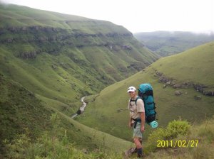
We started hiking from the car park at 5am.
Summit the chain ladders at 7am. We stopped countless times for awesome views of the landscape and wildlife.
The rain started once we were on the escarpment but didn't last long. The falls were nothing more than a trickle and standing close to the edge was impossible because of the gusting winds.
because of the weather we decided to skip our intended Mont Aux Sources summit and headed for Mount Amery Summit instead. We had to abandon ship 40m from the summit after I badly twisted my knee. We strapped it, had lunch where a mountain reed-buck almost ran into us before stopping dead in front of us before speeding of again, then headed for Ribbon falls to set up camp before the fast incoming weather and rugby final. We we just in time as the rain started once we pitched the tent. We sat in the tent listening to the rugby but being barely able to hear as the rain on the tent sounded like being inside a popcorn machine. What a game and what an experience it was. I wouldn't have changed my spot on the berg, struggling for better reception on the radio, for VIP ticket at Ellispark. I know some guys on VE wish they did rather go to the Berg, huh diverian?
Sunday was tough on my knee and we took it real slow and safe as possible. The mist in the Tugela basin was thick at times and we could not see another group of hikers 20m in front of us. We hooked up at the chains and they joined us for coffee at Sentinel cave. They were the first people we saw since leaving the car park at Sat morning.
To sum up.
I cant describe in word how spectacular this trip was. Thanks for all the advise and pointers from other members and a special thanks to Chris for this site!
Please login or register to view the images attached to this post.
Please Log in or Create an account to join the conversation.
