Two hikers got stuck on a descent of what they thought was Tseketseke Pass and were safely airlifted from a snow-covered Drakensberg on August 10th.

George Christian (49) and Jackie Celliers (45) phoned emergency services via cell phone on August 9th at 17:00. They had descended a steep gully which they had mistaken to be the pass, and after several hours realised their mistake. It seems they were unable to climb back up again because the snow was very thick (up to shoulder depth in places) and was starting to melt. They had also slid down some steep slopes. Some 12 hours later they were spotted waving their brightly coloured equipment and were airlifted without injury by personel in the Oryx helicopter from 15 Squadron which was dispatched from Durban.

The news report, which can be viewed at, http://jv.news24.com/Beeld/Suid-Afrika/0,,3-975_2546762,00.html, indicated that the hikers had turned off too early.

To me it seems like the False Tseketske Pass has claimed victims once again. From the escarpment, the true summit of Tseketske Pass is obscurely located and not that obvious. Instead, immediately South of a small dome – "Tseketseke Peak" (unnamed on the maps) - there is an obvious feature which looks like the summit of a pass. It leads into a gully which at first seems manageable but which eventually becomes a extremely difficult and steep, basically impassable. The true summit is a short uphill climb from the false summit.

Time and again I hear reports of hikers who have mistaken this to be Tseketske Pass. For many it simply meant they had to climb several hours back out again. For some the situation became more serious. The current story is a case in point. In December 2004 another hiker had to be airlifted from this gully after a huge boulder dislodged and smashed his legs. Read the report at http://www.capetimes.co.za/index.php?fSectionId=271&fArticleId=2360007%3E.

It is no wonder that the old Slingsby hiking maps had a warning written on them about not taking the false pass. Tseketseke Pass is relatively easy, and on an ascent hikers seldom face major challenges.  It is on a descent that the wrong gully can easily be mistaken to be the pass.

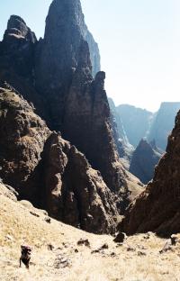
The picture below is taken from near The Elephant, above Cockade Pass. It shows how prominent the false pass is compared to the true one. Note how the two summits lie on either side of “Tseketseke Peak”.


falsetseke.jpg

If you are DESCENDING the pass and The Column and The Pyramid are NOT to your LEFT, then you are in the WRONG gully. Tseketeke Pass is mostly grassy on the upper reaches, with an easily negotiated, bouldery stream further down. The bottom of the pass tends to be very bushy and overgrown. If you are descending a very steep, dangerous gully, then you are not on the pass.

The following picture shows the view of The Column (left) and The Pyramid (right) which loom over you relatively high up on the pass.

columnpyramidfromtseke.jpg


Log in to comment


grae22's Avatar
grae22 replied to: #80177 27 Jan 2026 13:29
As passes go it's pretty straight forward, especially once you've found the way to the hut (as Smurfatefrog described above) - you can typically follow the path or take the most logical line. Does seem to see occasional traffic from Basoths. As with most passes - avoid camping near the top.
Jono26's Avatar
Jono26 replied to: #80176 27 Jan 2026 11:28
Does anyone else have current knowledge of the state of the Tseketseke pass and the viability of hiking up it to access the escarpment?


Smurfatefrog's Avatar
Smurfatefrog replied to: #80169 25 Jan 2026 14:47
Its boulder hopping from the contour path to about 1km past Tseke hut
The path starts on the right (heading up the pass) at spot where the river narrows and has a little waterfall.
There will be a track available in the downloads section
Jono26's Avatar
Jono26 replied to: #80165 25 Jan 2026 12:36
Can anyone advise on the current state of the Tseketseke Pass.  I'm checking out the viability of a group of moderately experienced and fit 60's+ hikers going up the pass in March, but it has been many years since I was on it.  Any recent information or advice would be appreciated, especially in relation to finding the way in certain sections (with or without a path), and any dangers following recent flood damage, erosion, unstable ground, exposure etc.
Sabine's Avatar
Sabine replied to: #78910 01 Mar 2024 13:40
I went up Tseke in November and found the path where it leads off the riverbed quite easily and onto the true left. You stay on that path until nearly the top. It was fine when we did it. Maybe finding the start at the top might be an issue plus the grass might have grown since
Riaang's Avatar
Riaang replied to: #78909 29 Feb 2024 12:19
Hi Alistair,

Welcome on VE!

Thanks for the feedback on Tseketseke pass. Note that this is a fairly common occurrence in the berg, especially late summer/early autumn. Lots of rain leads to overgrown paths :-) A technique I often use to find (and stay on ) the path, is to "feel" for a level section underfoot. Even though the upper sections of plant growth covers the path completely, quite often the path on the ground is still fairly clear as the vegetation grows up to find sunlight.

Another technique I also employ is to try and estimate where the path would logically be situated. Coming down Tseke pass, specifically the section you are referring to, you stay mostly on the left (true left) of the gully, and never venture too far from it. So, I would then assume that the ath would stay on this course, and should I veer off this assumed route, I would scout around to see if I went off the path by mistake, or if the path actually changed direction.

You will often find that paths tend to disappear in sections, or you get onto a game path by mistake, or thick mist rolls in, all of which leads to confusion. Don't let this put you off specific passes, that's simply part and parcel of the wilderness experience. Build in enough time/food/reserves/escape routes to cater for these type of eventualities as they happen. The more you hike, the less frequent the occurrences, but they still happen.

Before I started hiking in the berg, I was used to walking on nice paths with signposts, footprint markers etc, and my first few hikes were a bit unsettling, till I got used to hiking in the berg.

Enjoy exploring and bundu-bashing in the berg, it's all part of the experience!
Alistair DvanH's Avatar
Alistair DvanH replied to: #78908 28 Feb 2024 17:55
Hi All 
Came down Tseketske pass this last weekend (23/24 Feb '24) and just wanted to warn others that it's pretty intensely overgrown and difficult to follow on the descent.
The pass and path are both easily identifiable from the top and the initial grassy section is manageable (although steep). However, about 1,2 km in from the top (after one crosses a stream with  a small waterfall to your left), things start getting a little hairy. Because the path is so overgrown (and GPS signal patchy in the valley)  we found ourselves getting drawn down erosion routes into some pretty dicey situations.  For the stretch from 1,2km until you get into the river, best advice is just to stick as far left as possible- even if you can't see any path- you might not believe it, but it's there. 
At about 1,9km there's a Cairn in the riverbed, counterintuitively you need to  walk to it, turn right and double back along the bed, cross the river and come down with the Cairn on your left (you'll need to be in the river for this- and hope your Merrel's are as waterproof as they claim). From there on to the bottom, the pass is a pretty brutal river rock scramble- very unforgiving on knees and toes.
We had thought we could make it all the way down in about 2-3 hours, but we ended up taking double that. We had planned to push for Xeni Cave but were thankful to just make it to Tseketseke hut before we lost too much light.  The Hut's not the Ritz, but we were thankful for the shelter from the wind for the night. The pool / falls below makes for grand coffee spot in the morning!

Not sure what the status of the other passes in the area are, but I wouldn't recommend Tseketseke in it's current condition, definitely not for a descent and would hesitate to suggest it on the ascent. 

Hope it's helpful! 
TheRealDave's Avatar
TheRealDave replied to: #78031 06 Oct 2022 21:41
If you wanted to go up and down Tseketseke, it would make sense to stay in Tseketseke Hut (gear would probably be fine in there, but you can never be too careful in SA). That would also be easier for the teens if they're inexperienced, as Xeni Cave to the top is quite an altitude gain and Cockade/Xeni are not the easiest passes, though Cockade is very beautiful.
Smurfatefrog's Avatar
Smurfatefrog replied to: #78021 03 Oct 2022 10:02
I would also suggest a loop with Cockade and Tseke, although if some kids are struggling going up and down the same pass would be better as they could wait back.
If you do head between Xeni cave and Cockade, boulder hop up the river bed rather than heading to the contour path which is quite overgrown

Xeni cave, it should be fairly safe to leave gear unattended there, but perhaps rather stash packs just around a corner from the cave
1armbandit's Avatar
1armbandit replied to: #78020 03 Oct 2022 09:32
 thanks appreciate the quick response.
I have done Cockade before and recall looking at xeni thinking that looks pretty dam steep!
I have not used Xeni cave in 15 years, does it need to be booked ?and would it be a terrible idea to stash gear and leave it unattended in the cave all day? or a farily safe option?  
 
BergAttie's Avatar
BergAttie replied to: #78019 03 Oct 2022 08:55
Yoru plan can work but I would rather go up Cockade or Xeni pass from Xeni cave since Tseketseke is quite a way south on the contour path from the Xeni cave valley. Leslie pass can also work but hard work with some bushwacking. Also - add about 1 hour to your drive in to Injasuthi compared to Cathedral.
1armbandit's Avatar
1armbandit replied to: #78018 03 Oct 2022 08:33
Morning all , looking for some advice. I have a group of teenagers i will be taking to the berg for a 3 day hike. I would like to show them a pass but as a day hike. 
I thought of using Xeni cave as a base for 2 nights and then doing a day hike up and down Tseketseke. I would appreciate comments o the feasibility of this idea. 
My alternative plan was Marble baths cave and a day hike up and down leslies.  

Any advice would be appreciated. 
 
GWTennant's Avatar
GWTennant replied to: #77741 01 Jun 2022 08:39
Hi All

Has anyone done Tseketseke Pass recently? Just looking for an update on its condition after all the rain...

Thanks!
Geoff
Wandelaar's Avatar
Wandelaar replied to: #77557 31 Mar 2022 12:03
I would just like to thank whoever went up or down Tseketseke pass in the last week or so. We had to exit a hiker with a bad knee and following your path through the vegetation really helped a lot! Especially near the top where there aren't any rock cairns. 

Regards,
Wandelaar. 
intrepid's Avatar
intrepid replied to: #76078 16 Sep 2020 18:47

ruthtbl wrote: There is a typo in this article I believe. Under 'Access' the article refers to Fangs Pass instead of Tseketseke Pass.

Thank you, this has been fixed.
ruthtbl's Avatar
ruthtbl replied to: #76076 16 Sep 2020 10:43
There is a typo in this article I believe. Under 'Access' the article refers to Fangs Pass instead of Tseketseke Pass.
mike_cromberge's Avatar
mike_cromberge replied to: #75463 15 Nov 2019 18:39
Hi Vicki, how did your hike go? I'm interested to hear about the current condition of Tseketseke pass as I'm planning on going up over the long weekend in December.

Does anyone have a GPS track of this route? :)

  
Riaang's Avatar
Riaang replied to: #75244 12 Aug 2019 11:02
Here Herman was going the wrong way, i.e. carrying up the pass instead of going onto the bank on the right side as you ascend. I had to call him back and he then climbed back down onto the flat rock where I was standing.


This is the section of flat rock. Where I am standing you will find a cairn showing you where to climb onto the bank.
 
Riaang's Avatar
Riaang replied to: #75243 12 Aug 2019 10:58
Hi Vicky,

Let me be the optimist and say that your route selection per day is very doable and achievable. I normally take Berg newbies on this exact same route, or around to Twins cave and down via Mlambonja pass. Getting over Elephant/Mahout is a bit easier on tired legs than tackling Cleft peak and Ndumeni dome.

I would advise starting early, so you can get a good section of the pass done before it gets too hot.

Also, if you can get a track of the route and download it on your gps. There is a place where you need to exit out of the riverbed, if you miss this spot you will be having an adventure :-). Best way I can describe it is as follows: After about 1,7km's from the hut you will get to a section where there is a 3m high waterfall (if the river is flowing). Fairly large rocks lying around. There are cairns leading you onwards in the riverbed, but here you need to get onto the bank on the right hand side (as you are ascending). You will notice a flattish rock to your left if you turn around and look down towards the hut (which you won't be able to see from this point as it is around the corner). On the right side of the river (still looking down the valley) you will notice a couple of large, dead, pine trees about oh, 300m or so away. 

The dodgiest section for me follows soon after this, where you walk close to the edge about 15m or so above the riverbed (on your left). These side banks could very easily break off and fall down into the river. I normally hurry through this section, only about 30m long. Hereafter it's up and down over little side gullies, pretty steep until you get to the scree field at around 2550m. From here it is a real slog for about 300m (I ALWAYS struggle with this section!!!), then just the finall grassy secttion to the top. Hop over and about 200m down you will find a stream with water. Go left for Rolands, right for Twins.
elinda's Avatar
elinda replied to: #75233 08 Aug 2019 18:43
Hi Vicki

I would agree with Smurfatefrog - rather take your beginner hikers on an easier route.  In my personal opinion, Tseketseke pass is not that easy and is also full of loose rocks which can be dangerous, especially if hikers are not experienced
Smurfatefrog's Avatar
Smurfatefrog replied to: #75232 08 Aug 2019 15:14
Hi Vicki, 

The question is more about fitness than being a beginner.
A few weeks ago I took a fairly experienced (although not with berg passes) hiker this same route and after taking 4 hours from the contour path to half way up Tseketseke pass we decided to head back down to the hut.

Tseke pass is of average difficulty as far as berg passes go, probably quite comparable to Camel

So personally I'd take them on a warm up hike locally with lots of hills to test their fitness
Vicki's Avatar
Vicki replied to: #75231 08 Aug 2019 15:03
Hi, please can someone tell me if you think beginners would handle this potential route:

Day 1: hiking from Cathedral Hotel up the waterfall route, to Tseketseke Hut. Sleeping there on the first night.
Day 2: Hiking up Tseketseke Pass the next morning, across the top of the escarpment to Rolands Cave. Sleeping there.
Day 3: Hike down the Camel route to the hotel.

I have done the Camel to Rolands, but have no idea how difficult Tseketseke would be for beginners... Thanks!
GerritHuman's Avatar
GerritHuman replied to: #73196 12 Apr 2018 20:58
Wow it is a rare find to have photos of passes nearly 10 years apart.
Thanks for looking for the old photo and sharing it!
Riaang's Avatar
Riaang replied to: #73137 06 Apr 2018 20:15
Would be nice if that could happen at Ships Prow :-)
Spoke101's Avatar
Spoke101 replied to: #73126 05 Apr 2018 22:05

tonymarshall wrote: As the fun part of the VE Berg Trip 2, Intrepid, diverian and tonymarshall did a day trip up and down Tseketseke Pass, combined with felling and ringbarking pine trees in the upper Tsekeseke valley.

The previous day we departed from the hotel hikers parking area, past the stables and into the Tseketseke valley past the Blue Pools. Even low down the valley, there was evidence of flash flood damage from the March 2011 flash flood in the Tseketseke catchment.

We were to stay in the river bed the whole way to the Tseketseke Hut, our overnight spot (except for several detours out of the river to cut pine trees.) Near a large copse of pine trees which we tackled, spectacular views of the Camel, Organ Pipes and Castle Buttress were afforded from the bank above the river. Note the lone pine tree to the right in the photo.

As we approached the Tseketseke Hut from downstream, it was apparent how close the hut (in the centre of the photo below) had come to being destroyed in the flash flood, with the erosion adjacent to and downstream of the hut leaving it on an island.

Below is a view of the upper Tseketseke and Tseketseke Pass from the contour path, with Cleft Peak, Column and Pyramid dominating the skyline.


The next morning we headed upstream, and not far from the hut caught the first sight of the top of the valley and pass. It was to be a day of more boulder hopping.

We stayed in the boulder bed until about 2550 m where we found a trail on the left (southern) bank which followed the grass slope to the top of the pass at 3000 m. A view down Tseketseke Pass.


First post here, and thought I'd revive an old thread. Really found this pic interesting because I have great memories of coming down Tseketseke in late 2008 so I decided to do some digging and found this gem of a pic taken form nearly the same spot. The two pic's show resulting effect of the flood on the pass.