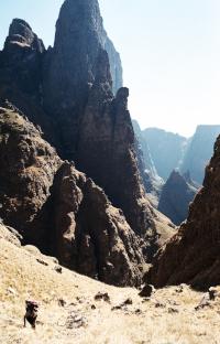
Leslie’s Pass is a pass which is very pleasant to hike. There are some great features in this pass like the Marble Baths and the huge cliffs of the Molar towering over you near the top of the pass. It is a fairly long pass but most of the distance is covered by bushwhacking and boulder-hopping up the river. This is also the most direct non-rock pass to access Mafadi which is about 6 km south of the top of Leslie’s Pass.


Rating:
* * * (6/10)
Difficulty of the pass is rated from 1-10 (10 being very difficult, only to be attempted by the fit and experienced). A subjective quality rating is indicated by the number of stars (1 being low, 5 being the highest). Factors such as scenic beauty and overall experience come into play here, which may differ from person to person.

Access:
It’s a relatively short walk-in (8 km) from the Injasuti Hutted Camp up the Injasuti Valley and to the right (north) up the contour path. The Marble Baths Cave is passed just before the descent into the valley which contains Leslie’s Pass.

Details:
The distance from Marble Baths Cave to the top of Leslie’s Pass is 6 km with an altitude gain of 1200m. 

Route:
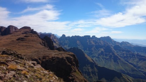
A clear path takes you down from the Marble Baths Cave to the Marble Baths themselves which are very refreshing on a hot day. From here, the path gets very vague but as long as you keep going upriver, you’re heading the right way. About 3 km up the river, a steep ridge coming from the Molar can be seen. The path climbs straight up this ridge and becomes more distinct from this point onwards. After a further 300m of altitude gain, the path takes you into the pass itself and crosses over a small stream to reach the southern slopes. After a short easy scramble through the rocks by the river, the path climbs up the grassy slopes to the base of the huge escarpment cliffs and then zigzags higher up to the top of the pass at 3100m.

Finding the pass from the top:
Leslie’s Pass is situated just south of the Molar on the edge of the escarpment. It is about 100m above the escarpment river valley and is clearly marked with a cairn.

Overnight Spots:
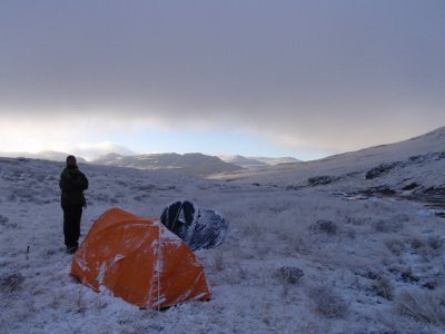
Marble Baths Cave is a good shelter sleeping 12 people at the base of the pass. There is a good place to camp just at the base of the ridge when the path leaves the river but it might not be too safe if the river would flood. As usual, there is lots of good camping on the escarpment itself.

Water:
There is reliable water for the first 3 km along the river but once you start climbing the steep ridge, the only available water is a seasonal trickle at the point where the path contours into the pass itself. There is also a river on the escarpment, 200m from the top of Leslie’s Pass.


Forum Topic:

More info can be found on the forum, here:

http://www.vertical-endeavour.com/forum/11-drakensberg-passes/53654-leslies-pass.html

You might also find this description of the terrace path between Marble baths and the base of the pass useful:

http://www.vertical-endeavour.com/downloads/download/4-drakensberg-hiking/166-leslies-directions-for-terrace-path.html

Log in to comment


RudiVE's Avatar
RudiVE replied to: #78115 06 Nov 2022 14:04
Hi Edward

The one time I did Leslie's I couldn't find the path from Marble Baths Cave to the base of Leslies so I did that section by literally staying in the river.  It took me about two and a half hours to cover the 4km.  I found the route to be okay.  Unfortunately I cannot compare it with the bushwacking section as I have never done that route before.   If you can find a gps track with that section you can maybe compare the time it took to cover the 4km and compare it to the 2.5hours it took me by keeping in the river.

Regards
Rudi 

 
intrepid's Avatar
intrepid replied to: #78097 29 Oct 2022 22:22
@Edward, I have merged your posts and the replies with the main, official thread on Leslie's Pass. Go through the older posts on this thread for more info.
ASL-Bivak#'s Avatar
ASL-Bivak# replied to: #78084 26 Oct 2022 16:12
LOL! I can add a few highlights of Riaan's comments! He's pretty spot on but I think I have made a few errors on Leslie's that made it harder than it should be..

The bushwacking is looong and is a real sweaty 'B' that never ends! Then the ridge starts inoccently enough but you will get to a section of Very steep path that goes straight up without contouring and is quite slippery to add to your pain (coming down is worse and If you pick up speed you are likely to end up on you ass. It seems Leslie didn't believe in contouring so make sure you have 2 trekking poles is my advice.

The 3rd dodgy aspect is that it's quite difficult to see that path when you get into the pass proper and I must stress that you should not be tempted to stick with the direct option going up the boulders. It's really physical and you end up using your hands to partially climb up the steep sections making it sooo much harder! So keep more to the left and make sure you track the path, it's quite loose in areas but still beats the semi climb up the 'direct' route. At Riaan's pt.2, it's that 2nd crossing of the river to move to the left side.
ghaznavid's Avatar
ghaznavid replied to: #78083 26 Oct 2022 10:50
I took my running club on a 3 day loop of up Around the Corner down Leslies in May. Incidentally Leslies Pass is now considered a swearword in my running club :lol:

The pass is fine, but the steep section above the river crossing halfway up can be very slippery, and the pass is long and steep.

Story with some pictures here:
jonathantheghaznavid.wordpress.com/2022/09/16/mafadi/

Riaan has given plenty of info, so I don't have much to add.
Riaang's Avatar
Riaang replied to: #78082 26 Oct 2022 09:45
Hi Edward,

Welcome to VE!

There are lots of info on VE relating to Leslies pass, both in trip reports but you can also find gps tracks in the downloads section. There's even a writeup on th epas itself under the Drakensberg passes section.

But, let me give you my view of it briefly.

Leslies pass is often used in conjunction with Corner or Judges pass to do a 3 day loop which includes Mafadi. People often stay over near the base of the pass at Marble Baths caves (there are 2 of them). Nice spot near the river. If you go up with Corner pass you can sleep over in Upper Injasuthi cave overlooking the Eastern Buttress immediately below you. Impressive views from this cave. Corner has 3 scrambling sections that, depending on the weather conditions, can be a bit challenging, especially in the snow, however, it's not technically difficult. The Trojan wall can be a bit of a bugger when you go up from the camp to UIC cave in a day, as it's near 400m vertical ascent stands between you and the overnight cave.

When I do Leslies pass I typically break it up into the following sections:
1). The bushwacking section: This part lies between Marble Bath Caves and the foot of the pass itself. The path (if you can find it) winds in and out of the river, but mostly stays on the right hand side of the river as you ascend. Often very overgrown with lush vegetation, and up and down rocky sections, this part can be a bit tiring towards the end of summer.

2). The ridge part: At some point (about 2.5km from the caves) you will exit the riverbed and climb on the ridge to the right of the river. It's fairly steep initially and gains height quickly. Once on top, it vectors gradually back into the riverbed, but higher up. A brief downhill section brings you to the river, which yu will now cross to be on the left of the river again.

3). Africa. This bushy section kinda has the shape of the African continent. The start is very steep and lover very loose, rocky ground. Definitely easier going up than coming down. Nice green bushy plants to pull you up and through this section. As you get to the top of Africa, you are approaching the next section.

4). The cliff face: As you exit Africa, you will be walking through loose rocks strewn all over the mountain. By now you've made good upward progress and the sun would be high in the sky, and it is becoming hot. No shade anywhere on this pass unfortunately. As you get to the cliff face itself, towering majestically above you, you will turn right and follow the path that leads to the top.

5). The top: The end is in sight. This last section is not too steep and the breeze from the top of the pass is refreshing. Once at the top its not too far down to the river below you where you can rest and top up with water.

Overall I normally enjoy this pass. It's steep and a bit rough, but has so much variaty that it never bores me. I'm sure you'll enjoy it a lot.

Enjoy the Berg!!!
Rossp's Avatar
Rossp replied to: #78081 25 Oct 2022 17:57
Hi Edward. I think there is a forum on Leslie's here already and quite a nice overview too. But anyway, I did the pass 2 weekends ago and I honestly found the 3km of bush between marble baths and the base of the pass to be the hardest part. Definitely add in an extra hour for this section! The pass itself is fairly straight forward and there's a path the whole way up. You start off by climbing steeply up a ridge on the right side of the river(the true left). At about 1/3 of the way up you leave the ridge and cross the river. The section just after the river crossing is quite badly eroded and full of loose rock, so just watch your footing (nothing incredibly dangerous though).

(Looking up the pass before crossing the river)
After the eroded section it's a simple slog to the top!!
Edward's Avatar
Edward replied to: #78080 25 Oct 2022 15:54
Good day all,

I am planning a trip to the Berg somewhere around new year's and was planning on including Leslie's pass as one of the passes to do. Does anyone have some recent info on the pass? I can't seem to find any, let me know if I am missing something. 

Thank you in advance.
 
TheRealDave's Avatar
TheRealDave replied to: #76368 12 Dec 2020 22:34
There is the Drakensberg Trail Project , which is still in the proposal stage with EKZNW. The focus at this stage seems to be contour paths more than passes.
grae22's Avatar
grae22 replied to: #76359 08 Dec 2020 13:44
Several nests of litter along the pass at the mo (tins, bones, foil, etc.) - I'm guessing due to Basotho heading home for xmas? We collected what we could, anyone inclined should probably go armed with a black bag or two.

To my eye the eroded bits are looking a fair bit worse than around a year ago, too - are there any private initiates doing path maintenance in the Berg?
Smurfatefrog's Avatar
Smurfatefrog replied to: #71168 16 Mar 2017 18:57
See this thread for options on the loop www.vertical-endeavour.com/forum/8-drakensberg-hiking/53639-corner-pass-judge-pass,-mafadi,-leslie-s-pass-loop.html

Corner Pass with a big group will take ages due to hauling packs
Judge Pass is not a rock pass these days, it has an easy to follow trail without any major obstacles, you'd likely find it considerably easier than Leslies, although its a bit further out the way
andrew r's Avatar
andrew r replied to: #71167 16 Mar 2017 18:00
Hi Kraig

I have not hiked from Injasuthi nor done any of the passes you mentioned, but Leslies Pass is often done in conjunction with Grays Pass (Monks Cowl) so look for hike reports and consider that as another option.

To manage your (very big) group safely and to minimise ecological impact I suggest you split into 3 clearly defined sub-groups with a spread of competencies within each group (i.e. don't put all the strong, experienced hikers in one group & all the rookies in a different group). Each sub-group should be self sufficient (maps, food, tents, etc) with an experienced leader so that if they get separated as a team they can look after themselves. Spread the sub-groups out a bit when you camp (but still within sight of each other if possible) and hike in your sub-groups, aiming to meet up all together for lunch etc. That way you will still be a group, have safety in numbers, but be more accountable to a smaller team and not put so much pressure on what is a very fragile ecosystem.

If your experience is anything like 'normal' you will probably have 30% of your hikers drop out before you even start, in which case you may want to hike as one group but break up into 2 groups with some space between them to camp.

Hope this helps.
DesPorter's Avatar
DesPorter replied to: #71166 16 Mar 2017 17:58
I am under the impression that there is a size limit for groups in the berg and that limit is 12. Thus the group should be split up and the various groups travel independently to different destinations. Can anyone clarify this?
Kraig's Avatar
Kraig replied to: #71165 16 Mar 2017 17:01
I have a group of approximately 20+ people, we plan to hike up to Mafadi from the EKZNW Injisuthi camp over the Easter weekend. My initial plan was to go up Leslie's pass and come down Judge or Corner pass or vice versa. I have done quite a few hikes a bit further north but haven't done any in this area. Furthermore there are a number of people for whom this will be their first hike. I saw now that Corner pass involves some scrambling so that plan won't work and Judge pass has Basotho traders and is labelled 'rock' so I don't think that's a good idea either. Do you think it is a feasible idea to take this many people up and down Leslie's in a 4 day hike and find sufficient space to camp? (it's not necessary for us all to camp close together)
ghaznavid's Avatar
ghaznavid replied to: #70056 17 Oct 2016 19:05
There is already a lot of info on this pass on this thread, so I won't say too much [hey, stop laughing]

We followed the river for most of the stretch from Marble Baths at the base of the pass. Boulder hopping is often faster than fighting through overgrowth.

The trail up the pass is clear till you hit the gully, then you just have to figure out that it goes up the spur in the middle. It is very eroded and loose - some form of reinforcement such as erosion barriers would be helpful.

We lost the trail through the top section, but it is easy to wind up the steep grass banks to the top.

The pass is steeper than average. The pass also starts quite low and tops out high. It was harder than I was anticipating.

The pass is worth doing, even if just for the views. I am not in a huge rush to do it again, but if I end up doing something like Injisuthi Pass some day, I could imagine making a round trip down Leslies.

Here are some photos from the pass:
Redshift3's Avatar
Redshift3 replied to: #66131 11 Dec 2015 15:45
Stunning pic's Dave! I hope to do the pass in mid January 2016. :hike:
TheRealDave's Avatar
TheRealDave replied to: #66130 11 Dec 2015 14:03
Here are some photos from a solo hike I did up and down Leslie's in September:

This image is hidden for guests.


This image is hidden for guests.


I found the riverbed far easier to navigate on the way down using the terrace route, the height advantage making the cairns easier to spot.

This image is hidden for guests.


This image is hidden for guests.


There is a steep bit in the path near the start of the bushy section (the darker mound on the left of the valley in the photo above) that is very eroded, so that you literally have to pull yourself up using the shrubbery on either side. This might get tricky if the erosion continues.

This image is hidden for guests.

tonymarshall's Avatar
tonymarshall replied to: #61198 30 Jun 2014 08:58
Yes, both top gullies are accessible, although I think it is more common nowadays to use the southern (left in the photo with green arrow) one. I think the southern one is probably a bit easier, but do know of people using the northern one when approaching the pass along the ridge from the north.
john mark 1's Avatar
john mark 1 replied to: #61196 30 Jun 2014 08:21
Thanks Tony! Are both of the two top gullies of leslies pass accessible? Which one is better to use or are both as good?
tonymarshall's Avatar
tonymarshall replied to: #61190 29 Jun 2014 20:22
Hi John, yes that is correct. Leslies Pass has two top gullies, both are visible in the photo and the other one is just to the right of the green arrow top in the photo.
john mark 1's Avatar
john mark 1 replied to: #61189 29 Jun 2014 17:10


Hi guys. This is one of Tony's pictures from his writeup. So would the red arrow be the molar and the green be the top of leslies pass?
Serious tribe's Avatar
Serious tribe replied to: #60686 14 May 2014 01:36
Mine too, love the place for a cool chill holiday. They must be from the early 80's i would say.
firephish's Avatar
firephish replied to: #60676 13 May 2014 15:27
nice to see those old injisuthi pics, definatley my favorite of the KZN wildlife camps :thumbsup:
Viking's Avatar
Viking replied to: #60675 13 May 2014 14:20
Wow, those are fantastic!
ASL-Bivak#'s Avatar
ASL-Bivak# replied to: #60674 13 May 2014 14:10
Upload not working on Firefox... :sick:
ASL-Bivak#'s Avatar
ASL-Bivak# replied to: #60666 12 May 2014 17:16
Check out this old post card the Parks Board is selling. The trees are still tiny...

Nice snow...