
Pitsaneng Pass North
There are 2 Pitsaneng Passes. The north one is a gully followed by a traverse and a ridge (top down) while the south one appears to be a simple gully with a crux high up.
Seeing as there was no thread on these passes, part 2 of my hike report will cover this.
When life gives you snow - part 2
Minaret Pass had taken too long, so Amakehla and Masubasuba Pass were out, but 6 passes could still fall to us.
After a lunch break above Minaret Pass, we traversed to North Pitsaneng.
The summit gully was severely snow choked. We all found ourselves waist deep in snow from time to time.
The gully splits about 20m down. We started down the true left gully before hitting a waterfall, then backed up and went down the true right gully and found another waterfall. We traversed back into the left gully via a traverse that wouldn't have been possible if most of the snow hadn't already melted on it. This put us below the earlier waterfall (which was iced up), but above another waterfall.
The GPS said we needed to traverse to the left, so we did.
The first snow ledge was fine, exposed, but not steep enough to fall off. The second was worse, but we made it across easily. The third ledge, however, is where we came to an abrupt halt.
Hobbit made it across, Andrew made it across, and someone who goes by the name of a random Persian dynasty that no one has ever heard of (no names mentioned) found himself unable to get through a tricky spot. In dry conditions this would be easy. The traverse was above a death fall on very steep snow, melting in the late afternoon sun.
It felt like months while I tried to find the way through. I went back and tried a higher line, but still no luck. Andrew came back to see what was up, and told me that it is worse on the other side. He eventually made the call that we need to turn back. Hobbit was clearly annoyed - this meant he would not be getting 4 passes on day 3, but we all have limitations. The mountain isn't going anywhere, we will be back and we will knock off this pass.
Snow in South Pitsaneng looked insane.
In the final summit gully, now well out of the serious danger - Hobbit made a meal of getting stuck in the snow. Simultaneously I found myself bringing down a mass of snow every time I tried to move up the gully near him. Fortunately (or sadly, depending on perspective), Andrew was too slow on getting his camera out - and soon we were back on a windy escarpment.
We motored it to Sandleni Cave, getting there after the sun went down, but before it was completely dark.
The cave floor was frozen, with plenty of ice outside as well. The drip at the back of the cave provided our water needs.
Not close to going according to plan, but at least we had bagged the hardest pass in the area and were all safe and warm in our sleeping bags.
Please login or register to view the images attached to this post.
Please Log in or Create an account to join the conversation.

Please Log in or Create an account to join the conversation.
Both are marked on the Geomaps series.DesPorter wrote: Thanks for the write up but unfortunately these names are just that, names. If there was a map with annotations it would be so much more meaningful.
They are east of the Stones Passes and west of Minaret Pass. They are probably not used very often due to the very long walkout to Cobham. Wilson's Cave is found at the base of them.
Please Log in or Create an account to join the conversation.
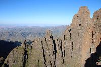
Ghaz contemplating the exposure on the traverse between the waterfalls while still in the main gully
Ghaz heading out on the traverse just before the point where we turned back
Please login or register to view the images attached to this post.
Please Log in or Create an account to join the conversation.
Please Log in or Create an account to join the conversation.
That can't be the spot where we turned around - that looks way too easyAndrewP wrote: Ghaz heading out on the traverse just before the point where we turned back

[insert some logical excuse here]
Please Log in or Create an account to join the conversation.
Firstly a disclaimer - from a navigational point of view, this is the hardest pass I have ever done. Seeing as my first attempt was in snow, and my second attempt was after it was burned, meaning no grass tufts to pull on, perhaps my opinion is skewed - but route finding is really tricky on it. Not a great route for inexperienced hikers, and not the most dramatic route ever - so not one I would recommend.
The route we used was as follows:
1) Drop down the initial srambly gully until a small exposed grass ledge is visible on the left. Walk along this grass ledge (very exposed in places) till you find a narrow gully right at the far end to scramble down.
2) Traverse this ledge for about 500m, trying not to fall to your death on the sketchy bits
3) You will see a side sloping grass ledge right next to a cliff and above a large drop - head down this
4) Follow the ridge till you near a cliff, at which point we took the left scree gully as it clearly gets through the last remaining cliff bands
5) Once you are below the cliff bands, the pass becomes a very simple grass ramp and the rest is easy
6) Don't forget that the pass bottoms out in the middle of nowhere

In summary - if you are adamant that you want to bag every pass on the maps, and conditions are good, I guess it is worth doing. Otherwise this pass is best skipped.
Hike report at this link
Please login or register to view the images attached to this post.
Please Log in or Create an account to join the conversation.
Please login or register to view the images attached to this post.
Please Log in or Create an account to join the conversation.
AndrewP wrote:
ghaznavid wrote:
Please Log in or Create an account to join the conversation.
Over the weekend, Graeme and I did the West Pass. It is a standard gully - so much easier to navigate than the East Pass. We came down the pass, which was probably the easier way of doing it. There is a crux right near the top, but if you traverse left above it, there is a side gully that skips it - which is much less exposed and easier scrambling. The pass has a lot of easy scrambles below this, but nothing too serous.
The short summary of the pass is that any experienced team who aren't bugged by occasional exposure and some scrambling should be fine. Not ideal for beginners, though.
The bypass around the crux:
The crux if you stay in the main gully:
Full Hike report
Please login or register to view the images attached to this post.
Please Log in or Create an account to join the conversation.
