
Verkyker Pass
Highlands Fanatic wrote:
intrepid wrote: I tend to opt for ridges and traverses.
+1.
Only the lack of water is sometimes an issue on ridge routes, but by far what I prefer too.
Me too.
Please Log in or Create an account to join the conversation.

We're going up Mashai to climb Rhino, Mlambonja and the "other peak" North of Rhino this Saturday and had planned to go North and down Mzimkhulu Pass and link up with the Giant's Cup Trail and home from there (we have a house on the Drak Gardens Road).
Is it best to go along the escarpment or a bit inland?
Has anyone got the GPS co ordinates for the top of Mzimkhulu Pass? (EDIT - got something off of Berg.co.za)
Is there any path heading north from Rhino area or is it all off camber ugliness?
Thanks in advance!
Andrew
Please Log in or Create an account to join the conversation.
- Andrew5336
-

- Offline
- Senior Member
-

- Posts: 30
- Thank you received: 4
Andrew5336 wrote: We're going up Mashai to climb Rhino, Mlambonja and the "other peak" North of Rhino this Saturday and had planned to go North and down Mzimkhulu Pass and link up with the Giant's Cup Trail and home from there (we have a house on the Drak Gardens Road).
The Giant's Cup Trail is very far from Mzimkhulu Pass - you would normally follow the Mzimkhulu river back to the nearby farm (via the Mzimkhulu Pipeline) or traverse the small Berg back to Garden Castle car park. I haven't done the Mzimkhulu Pipeline route before, but I have done the small Berg traverse route, it is slow going and requires tackling some rather substantial hills.
Andrew5336 wrote: Is it best to go along the escarpment or a bit inland?
Is there any path heading north from Rhino area or is it all off camber ugliness?
I can send you my GPS track for this bit of escarpment if you like, there are occasional trails, but nothing of much use - and the usually last for about 100m and go in the wrong direction. The easiest route is to shoot for the col to the left of Verkyker Peak (as seen from the south). Just pick a line and slowly zig-zag up the hill.
From the north side it should be relatively easy to spot the Mzimkhulu Passes if the weather is clear (well, once you are around the non-khulu I call Verkyker Pass peak). The north pass is in a massive cut back. Once over the Verkyker ridge, follow the stream bed down the hill and begin to traverse out of it as you get lower (otherwise you end up hitting the top of Verkyker Pass).
Don't underestimate how long it will take to get up Mlambonja Peak, it is part of a glaring 3 khulu gap in an area where my khulu stats are generally good. It is a real monster of a peak.
Please Log in or Create an account to join the conversation.
Ja I had a look at the distance from the top down to Giant's Cup and it does look...ambitious haha.
We'll be running on the flat and moving fast on the downs - Rhino from the car park to peak and back is less than 3 hrs 30 for us but I think those 3 Khulus and then maybe down Rhino Pass and over the ridge back to Garden Castle will be a good day!
Awesome, keen to bag some peaks - I'm about 2 Khulus into my list haha.
Have a great day all.
Please Log in or Create an account to join the conversation.
- Andrew5336
-
- Offline
- Senior Member
-
- Posts: 30
- Thank you received: 4
There are 2 ways of approaching Rhino Pass from the car park - you can head over the bridge and follow the high ridge approach, alternatively you can hike to Pillar Cave, slog up to the col between Rhino Peak (Eastern Arete) and the large unnamed flat top peak next to this. Once through the col you would slowly traverse to the river to pick up the pass. Considering that you are running it, the 4km of trail at the start will probably help.
Good luck and don't forget to post a report

Ps. you want a great spot to hit many khulus in a day, head to Giant's Castle. Myself and Hobbit did 3 in a day earlier this year - up North Jarding, climb Potterill, Bond and Erskine, down Langies and back to the car.
Please Log in or Create an account to join the conversation.
Before heading over the Verkyker Ridge, I went to check out Pigeonhole Cave. It wasn't exactly where the GPS co-ordinate I have for it is, and it looks like a bit of a scramble to get up to. Not the greatest cave I have ever seen, but it would do in an emergency.
I descended Verkyker Pass. It was actually more dramatic than I expected. The top has a bit of a trail, which dies off soon. The top section is fairly easy with standard grass slopes. You get forced into a boulder field - which is mostly stable. Admittedly when you are hiking solo and the large rock you stand on moves, you do become a bit more careful! Once through the rocky section, I broke left (north) onto the grass slope. I crossed the ridge between Verkyker Pass and the Mzimkhulu River and dropped down to the Mzimkhulu pass trail on the other side. I hit the trail at 2350m, where the Mzimkhulu River was shockingly dry.
Full story at this link .
Please login or register to view the images attached to this post.
Please Log in or Create an account to join the conversation.
Please Log in or Create an account to join the conversation.
- petroengel
-
- Offline
- Senior Member
-
- Posts: 39
- Thank you received: 2
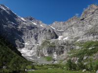
After overnighting in Fun Cave, we continued along the path of North Mzimkhulu Pass, and cresting the top of the Little Berg above Fun Cave had the view to Verkyker Pass and the Mzimkhulu Passes in the photo below.
Further up the valley, the path ascends steeply up a ridge to pass in front of Speir’s Cave, in the light coloured sandstone outcrop in the photo below.
We took a short break at Speir’s Cave, viewing the rock art in the cave, which is named after Robert Speirs, who spent a night there alone after becoming separated from the rest of a group of settler farmers who were pursuing stock thieves, and descended North Mzimkhulu Pass after the infamous incident which resulted in the death of Thomas Hodgson, after whom Hodgson’s Peaks are named. The photo below shows Speir’s Cave, with one of the many panels of rock art visible at the left of the photo.
Just after Speir’s Cave we left the path, going steeply up the ridge to the left. Looking back down the ridge, with the rocks above Speir’s Cave at the right of the photo below.
Continuing in a gentle curve to the left the ridge led towards Verkyker Pass, which ascends between the two peaks in the photo below; Verkyker on the left and Verkyker North on the right.
At the end of the ridge, we ascended a steep grass gully.
The view down the grass gully, with the Mzimkhulu valley in the background.
Please login or register to view the images attached to this post.
Please Log in or Create an account to join the conversation.
- tonymarshall
-

- Offline
- VE Advisory
-

- Posts: 740
- Thank you received: 2097
A view back along the traverse.
We took a morning break at a narrow grass ledge that led into the gully of Verkyker Pass.
After the break, Intrepid and I went up the pass ahead of the rest of the group to summit some khulus, and arranged to meet the others at the top of Verkyker Pass for lunch. The photo below shows the view up the top section of Verkyker Pass.
The view back down Verkyker Pass.
The view up the final grass slope to the top of Verkyker Pass.
After summiting Verkyker and Verkyker Buttress, Chris and I rejoined the group at the top of Verkyker Pass, and took our summit photo of the pass, fltr Kim, Chris, Kelly, Karen, Warren and Tony.
That afternoon we descended South Mzimkhulu Pass, joining the North Mzimkhulu Pass path at the bottom of the pass and returning along the path via Speir’s Cave to again overnight at Fun Cave.
Please login or register to view the images attached to this post.
Please Log in or Create an account to join the conversation.
- tonymarshall
-
- Offline
- VE Advisory
-
- Posts: 740
- Thank you received: 2097
