
Lotheni Pass South Fork
14 Jul 2010 19:04 #1475
by anthony
Lotheni Pass South Fork was created by anthony
We are keen to do these two passes over three days, is this possible, and what are the conditions of these passes like.
Please Log in or Create an account to join the conversation.

16 Jul 2010 12:54 - 16 Jul 2010 13:06 #1484
by intrepid
Take nothing but litter, leave nothing but a cleaner Drakensberg.
Replied by intrepid on topic Lotheni Pass South Fork
You can get up Giant's Castle Pass easily in a day from Giant's camp. It's an average pass with a fairly good trail most of the way.
Lotheni Pass has 2 distinct forks, the North Fork is the one indicated on the maps and is definitely a rock pass. The South Fork (the one the cave is in) is a smuggling route complete with a track, and is a much more obvious (and easier) pass than the North Fork (why that fork even got the official title is a mystery to me). The trail contours along the Ka Pitoli ridge and eventually flips over into the next valley in the vicinity of Killer Ridge - that's as far as I've followed it. From there it possibly follows Elandshoek valley out, or it heads on towards Taylor's Pass / The Sisters area where is might link up with yet another smuggling pass which starts near Giant's Castle summit.
Your day 2 would be to descend Lotheni Pass and get as far as possible towards the junction near Taylor's Pass / eChibini Tarn. You might be able to follow smuggling tracks for most, if not all of that. On the other hand you might also face navigational challenges and a bit of bundu-bashing. Day 3 would be relatively easy once you've rejoined the highways of Giants Castle area.
So, while it sounds like could pull it off in 3 days, consider 4 as an extra, also to enjoy it more, and even to climb Giant's Castle, especially if you haven't done it before.
Take nothing but litter, leave nothing but a cleaner Drakensberg.
Last edit: 16 Jul 2010 13:06 by intrepid.
Please Log in or Create an account to join the conversation.

01 Aug 2010 15:43 #1535
by Serious tribe
Replied by Serious tribe on topic Lotheni Pass South Fork
There is also a cave in Giant's Pass not far from the top on the lhs, that will fit an isodome tent. We slept 4 in the tent one evening, it was a bit squashed but bearable.
Please Log in or Create an account to join the conversation.
- Serious tribe
-

- Offline
- Platinum Member
-

Less
More
- Posts: 924
- Thank you received: 462
09 Sep 2016 20:51 #69731
by Richard Hunt
Replied by Richard Hunt on topic Lotheni Pass South Fork
Hi Guys...We are planning a hike in October and we want to come down Lotheni Pass and are struggling to find any information on this Pass. Where does this route down Lotheni Pass come out at? Does it go over Ka-Pitoli Ridge joining into Elandshoek Pass route or does it come out on the eNtubeni Pass/Ash Cave route. If anyone has done this route your help will be appreciated.
Please Log in or Create an account to join the conversation.
- Richard Hunt
-
- Offline
- Platinum Member
-
Less
More
- Posts: 328
- Thank you received: 725
10 Sep 2016 12:49 #69733
by Biomech
Replied by Biomech on topic Lotheni Pass South Fork
Hi Richard. The route comes out at the eNtubeni Pass route and on past Ash Cave. It is also possible to go over the ridge to the Elandshoek side.
Please note that there is a strong path all the way down the pass, but it pretty much disappears after that until you get down to Ash Cave. Lots of rock hopping and bundu bashing fun. The route over the ridge has a path up the ridge, but it disappears when you enter the valley again.
We crossed over the Lotheni River 3 or 4 times on the way down when forced to, but we mainly kept to the true right of it as the maps have this as the route. Again I can emphasise, there is NO path, despite there being one on the map!
Hope this helps.
Please Log in or Create an account to join the conversation.
11 Sep 2016 11:34 #69737
by Richard Hunt
Replied by Richard Hunt on topic Lotheni Pass South Fork
@ Biomech: thanks for that information We are planning to walk back from Lotheni Pass to the Lotheni Camp site along the Pitoli Ridge, which you said can be accessed from Lotheni Pass. I wonder if anyone has walked along that Ridge and how far they were able to go. I see towards the end of Pitoli Ridge nearer Lotheni Camp Site some very steep gradients Mmmm!!!!!
Please Log in or Create an account to join the conversation.
- Richard Hunt
-
- Offline
- Platinum Member
-
Less
More
- Posts: 328
- Thank you received: 725
12 Sep 2016 10:01 #69746
by Biomech
Replied by Biomech on topic Lotheni Pass South Fork
The little berg sandstone cliffs tend to drop off very quickly near the end of the ridges down to the Lotheni Camp. We did quite a bit of bum sliding!
The following user(s) said Thank You: Richard Hunt
Please Log in or Create an account to join the conversation.
14 Jan 2018 20:17 - 14 Jan 2018 20:30 #72639
by tonymarshall
Replied by tonymarshall on topic Lotheni Pass South Fork
Lotheni Pass South (Main access)
In 2017 I did Lotheni Pass twice, on the March long weekend with Lorinda and Sue, and in April over the Easter long weekend with Elinda, Richard Hunt, Thora, SingleSpeed and Papa Dragon.
Lotheni Pass is the common name for Lotheni Pass South, which has two short minor variations to the top of the pass, the main route, and the gully route. Lotheni Pass North is a Rock Pass just north of Lotheni Pass, branching off from Lotheni Pass about half way up, and is incorrectly shown on the hiking maps as Lotheni Pass, and should not be confused with Lotheni Pass / Lotheni Pass South.
Surprisingly there are no pass write ups on VE for Lotheni Pass (although it is mentioned in a few trip write ups), and combined with the fact that I did it up from Ash Cave using the main route in April, and down using the gully route and out via kaPitoli Ridge over Easter, I will do two full write ups, rather than try to merge photos from both trips into one write up.
While researching the March hike I could find very little information on Lotheni Pass, other than the gps track download and ghaznavid and Biomech’s trip write up references, and even less information on Ash Cave, a cave near the base of Lotheni Pass that we wanted to use as an overnight stop before ascending the pass. I will therefore also do a separate write up on Ash Cave, incorporating the walk in to Ash Cave from Lotheni office into that write up, and will commence this write up of Lotheni Pass ascent from Ash Cave.
Lorinda, Sue and tonymarshall departed from Ash Cave, walking along the base of the rockband in which Ash Cave is situated, before descending a section of gentler slope into the river valley below. We would then fairly closely follow the course of the river upstream once reaching the river valley. The photo below shows the view back to Ash Cave, in the rock band in the background more or less at the centre of the photo as we headed upstream in the river valley.
A view upstream, with the prominent waterfall visible from Ash Cave.
In the section upstream of Ash Cave we were mostly on the left (true right) of the river, but crossed the river four times and were on the right for two short sections.
The scenery in the steep sided valley was quite monotonous, but the waterfall we passed was quite spectacular.
A view back downstream, walking in the bush of the river valley.
A view ahead, walking on the more grassy sideslope.
There was no trail in this section, so we just found our way using the path of least resistance (haha), sometimes in the bushy river bed and sometimes on the grassy sideslope, which were both rough going. We did see rare evidence of the trail that once existed here, but it was impossible to follow. The photo below looking back downstream gives a good impression of the bushy terrain and why this route is seldom used.
After a tea break at the river, we crossed to the right (true left) and followed a more level grassy slope upstream, which we found much easier going than being in the river valley.
The morning had been cloudy/misty, and it cleared just at the right time to reveal the escarpment and provide us our first view up Lotheni Pass. Lotheni Pass is to the left of the (as far as I can determine) unnamed prominent outcrop at the centre of the photo below, while Lotheni Pass North is to the right of the outcrop.
We were fortunate to be on the right of the river, as we picked up the trail quite easily on the right, just before it descended to cross a side steam. The photo below shows a view of Lotheni Pass from the trail at the top of the slope of the side stream valley entering from the right. From Ash Cave to where we joined the trail (coming from/going to kaPitoli Ridge) of Lotheni Pass was just under 5 km of bundu bashing, and it was a big relief to be on the trail. The trail would descend to cross the side stream, and then follow the low ridge at the centre of the photo to ascend the pass.
Please login or register to view the images attached to this post.
Last edit: 14 Jan 2018 20:30 by tonymarshall.
Please Log in or Create an account to join the conversation.
- tonymarshall
-

- Offline
- VE Advisory
-

Less
More
- Posts: 739
- Thank you received: 2093
14 Jan 2018 20:21 - 15 Jan 2018 11:21 #72640
by tonymarshall
Replied by tonymarshall on topic Lotheni Pass South Fork
The going on the pass was much easier with the trail. The photo below shows the view back down the lower section of the pass, with the low ridge and sidestream previously mentioned visible.
We stopped to have lunch not far below the stream crossing, where the trail crossed from the right to the left, where we were close to the stream for water. The photo below shows the view up the pass, where the trail crosses to the left about half way between our lunch spot and the base of the prominent outcrop, and then follows the grassy slopes upwards on the left.
A view back down the pass, after the trail crossed to the true right.
A view ahead up the pass, where the gradient of the trail alternated between flat and steep to cross through the rock bands.
A view back down the pass, showing the general terrain, as the mist came in around us.
A view up, nearing the top of the pass.
Lotheni Cave is near the top of Lotheni Pass, and just below the cave the routes split, with the main route to the left (south) passing below the cave, and the gulley route to the right (north east) going past the cave, with the cave in a recess on the left. We left our packs at the junction and went to look at the cave. The main sleeping area of Lotheni Cave had grass on the floor, which was covered with some dirty sheeps wool. It wasn’t clear why the wool was there, and we wondered if a sheep had been slaughtered there, the thought of which made the cave rather unappealing.
There was another damp sleeping area to the left of the main area, and a sloping area to the right.
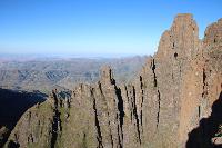
The cave is in the recess at the right of the photo below, above and behind the large boulder in the foreground. The main route of Lotheni Pass goes up the slope behind Lotheni Cave and can be vaguely made out on the grass slope at the left of the cave, before going up to the right behind the cave
Our misty summit photo at the top of Lotheni Pass. Sue had picked up quite a large feather near the top of the pass, and felt that doing Lotheni Pass was a feather in her cap.
We headed south, and that night we camped near the base of The Tent, and the following day summited several khulus before descending Redi Pass.
Other write ups to follow as I get time.
Mod note- Merged with previous Lotheni Pass thread
We stopped to have lunch not far below the stream crossing, where the trail crossed from the right to the left, where we were close to the stream for water. The photo below shows the view up the pass, where the trail crosses to the left about half way between our lunch spot and the base of the prominent outcrop, and then follows the grassy slopes upwards on the left.
A view back down the pass, after the trail crossed to the true right.
A view ahead up the pass, where the gradient of the trail alternated between flat and steep to cross through the rock bands.
A view back down the pass, showing the general terrain, as the mist came in around us.
A view up, nearing the top of the pass.
Lotheni Cave is near the top of Lotheni Pass, and just below the cave the routes split, with the main route to the left (south) passing below the cave, and the gulley route to the right (north east) going past the cave, with the cave in a recess on the left. We left our packs at the junction and went to look at the cave. The main sleeping area of Lotheni Cave had grass on the floor, which was covered with some dirty sheeps wool. It wasn’t clear why the wool was there, and we wondered if a sheep had been slaughtered there, the thought of which made the cave rather unappealing.
There was another damp sleeping area to the left of the main area, and a sloping area to the right.
The cave is in the recess at the right of the photo below, above and behind the large boulder in the foreground. The main route of Lotheni Pass goes up the slope behind Lotheni Cave and can be vaguely made out on the grass slope at the left of the cave, before going up to the right behind the cave
Our misty summit photo at the top of Lotheni Pass. Sue had picked up quite a large feather near the top of the pass, and felt that doing Lotheni Pass was a feather in her cap.
We headed south, and that night we camped near the base of The Tent, and the following day summited several khulus before descending Redi Pass.
Other write ups to follow as I get time.
Mod note- Merged with previous Lotheni Pass thread
Please login or register to view the images attached to this post.
Last edit: 15 Jan 2018 11:21 by JonWells.
The following user(s) said Thank You: elinda, Stijn, JonWells, Bigsnake, ghaznavid, hikingle, Smurfatefrog, ruthtbl, Richard Hunt, Papa Dragon, Biomech, TheRealDave, Gudstff, WarrenM, AnoukBaars
Please Log in or Create an account to join the conversation.
- tonymarshall
-
- Offline
- VE Advisory
-
Less
More
- Posts: 739
- Thank you received: 2093
14 Apr 2024 20:49 - 14 Apr 2024 20:50 #79022
by tonymarshall
Replied by tonymarshall on topic Lotheni Pass South Fork
In early March, The Real Dave and tonymarshall did a four day hike at Lotheni, ascending eNtubeni Pass on the second day. We would head along the summit to the top of Lotheni Pass South, and go down the top section of Lotheni Pass to Lotheni Cave where we planned to overnight. Hiding our packs at the cave, we descended Lotheni Pass South to the river crossing, and then ascended Lotheni Pass North.
This is just an update on the state of the path on Lotheni Pass South, which is mentioned in the previous posts on the pass, and visible in the photos in my posts, and was a very good and well used path when I did the pass in 2017. The path has now fallen into disuse, and is almost non existent in places, with other sections being very eroded, and the eroded sections are quite visible. Perhaps because of the erosion, the locals that made and used the path, are no longer using it.
We only went as far down on the remains of the path as the river crossing, but it can be assumed that the section of path on the pass below this, and going out of the valley onto KaPitoli Ridge, is similarly affected. So please be aware that the path in the previous write ups which was very useful for doing Lotheni Pass, is now no longer as useful, and this has a significant impact on the time required for doing the pass.
I will put the same information on the thread for Lotheni Pass South – gully access, for record and information purposes.
Last edit: 14 Apr 2024 20:50 by tonymarshall. Reason: Correct formatting
The following user(s) said Thank You: TheRealDave
Please Log in or Create an account to join the conversation.
- tonymarshall
-
- Offline
- VE Advisory
-
Less
More
- Posts: 739
- Thank you received: 2093
