Wolkberg Hike Report March 2014
27 Mar 2014 14:45 - 27 Mar 2014 15:11 #60051
by susanalkema
Wolkberg Hike Report March 2014 was created by susanalkema
WOLKBERG HIKE REPORT MARCH 2014 (SERALA PEAK LOOP)
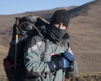
Over the long weekend in March we set out for our 3 day overnight hike. Our 3 day hike turned into a 4 day hike (with search rangers sent out and worried family and friends waiting at home on Monday).
The dirt road to the Serala forest station is in a very good condition currently. A normal car (not too low on the ground) will be sufficient, although a bakkie is always more practical. They have very basic amenities at the campsite. The showers will be cold if the donkey (fire pit that heats the warm water) isn’t lit. So don’t expect a warm shower coming back stinky and dirty after the hike. GPS co-ordinates to the Serala Forest Station: 24° 2'55.73"S, 30° 0'19.73"E.
The few very valuable lessons we learned was the following:
• A panga and pruning scissors is essential
• Take essential climbing ropes/gear with for going down the steep sections
• Get used to river crossings (eventually you get tired of taking off shoes and putting them back on again, so wet shoes it is!)
• Which is why you will never pack in enough dry socks (grandma-feet deluxe)
• Wear long pants, unless you want really scratched legs (bush whacking is inevitable and even the real paths make real damage)
• You can have good cuisine hiking food with little effort and weight
Our route was the following:
• Day 1: Serala Forest Station to top of lower mountains (Close to MCSA Hut) = 12.8km
• Day 2: Top of lower mountains (east of Bumb slides) to Cleopatra pools, via Serala Peak (going up Serala on the Northwest side) = 5.68km
• Day 3: Cleopatra pools to Serala Forest Station, via the Wonderwoud ravine = 9.47km + 7.32km (Day 4)
Day 1: Serala Forest Station to top of lower mountains (Close to MCSA Hut) = 12.8km
Our original plan was to have the first camping place at the bumb slides. Needless to say that we never found our route there. And with the past two weeks of torrential rains and flooding we decided against going bolder hopping up a river. Luckily we had a contingency plan and had another route mapped with another camping place.
We filled in the mountain register at the offices packed the last gear in our bags and set of @ 09:30 am. You start by going down a jeep track.
The jeep track then leads you into a forest section with a 500m elevation loss over about 4km.
Then you find yourself in the valley where you head left following the Mohlapatse river on your right.
Some of this section was unclear paths and quite thick grass/bushy sections. Try and find the jeep track running along there as soon as possible… Before crossing the Mohlepatse river we stopped for lunch.
Earlier we passed a group of 4x4 enthusiasts who notified us that the jeep track we are wanting to follow was turned into a river for about 1km. So after lunch my boots went off and my Crocs came on (if you don’t have Crocs, it is a very good idea to get some). Walking over the river and on the river-jeep-track was a breeze for me and not so much for the people in the group walking barefoot.
Now a slight climb is to follow still heading up the river. Here we made a decision not to head towards the bumbslides and rather head to the top of the lower mountains. We veered of to our right following a jeep track all the way up. The scenery started changing into plantation sections. Some sections were extremely slippery, hardened, wet mud; and it really helps having the support of hiking sticks.
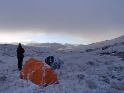
After a good climb we reached the top of the hill. This is about the same height as the MCSA Hut. We started looking for a camping spot near water. We found a wonderful spot nestled in between Pine trees and a beautiful cascading stream a few metres away.
We set up camp, and cleaned ourselves in the refreshing stream (warmer than Drakensberg streams). A delicious dinner followed…Belinda prepared for us Chickpea Masala. A winner recipe! With my tummy filled we all set off to bed early seeing as we were all up since 2am in the morning.
Day 2: Top of lower mountains (east of Bumb slides) to Cleopatra pools, via Serala Peak (going up Serala on the Northwest side) = 5.68km
It started raining somewhere early morning, drizzling until about 7am. We did lie in a bit because we thought it would only be an easy 5.68km hike… Here’s another lesson: never underestimate the Wolkberge…
We walked towards the MCSA Hut. Just before the hut we veered right, going up towards Serala peak following a very overgrown old jeep track, which could now qualify as a single track. The jeep track looks like a rocky ridge.
Our jeep track disappeared into a thick tree section. Izak spotted a waterfall straight ahead. We decided to go have a look before trying to find another way around our jeep track disappearing. It was a beautiful 8m waterfall. As the guys were discovering the waterfall they realised that the jeep track actually continued over the waterfall and was covered by a fallen tree. And here is another lesson: fallen trees make lots of paths disappear…
We continued on the steady climb. The jeep track came and went, and we had to trek through a bit of thick fern/grass sections. We followed the jeep track till it stopped. We stopped for lunch at a small stream with nice tree cover, getting out of the sun was a nice break.
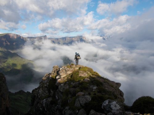
Ahead laid the last steep section up Serala peak. This was free for all when it comes to path finding. So you had to find the easiest way up the hill. Only the last section did we meet up with an existing path that came from the MCSA hut. We met up with another day hiking group going up Serala peak and made our way up all the way to the top following a path. We dropped our bags for the last section up as we were going to come back down the same way.
After enjoying the view and taking a view pictures we made our way down to Cleopatra pools. Here also are no real paths until you are almost at the camp site. The vegetation is not too difficult up at the top.
Almost at the camp you get to see a glimpse of why people go hiking in the Wolkberg. It’s absolutely beautiful! The pictures will describe this. Reaching the camp you are met with a river that goes over the edge of a +-90m drop off a cliff. This has been the best camping spot of the whole hike!
We setup camp and then set off to go explore the near cliffs before dinner. We took full climbing gear with so we looked for a place to abseil off a cliff. Finally finding a good spot we set the ropes up and Belinda got to abseil, and then darkness crept in.
Luckily we took headlamps with and walked back to camp in the dark and started dinner.
Cobus made tasty seafood Payela for dinner, and it was accompanied by a small bottle champagne that Cobus got for his birthday. We admired the stars before tucking in for a good night’s rest.
Day 3: Cleopatra pools to Wonderwoud, going down Kruger’s Nose and then into the Wonderwoud = 9.47km
We decided to get up at 04:30am because we were expecting day 3 to take long, seeing as we will have to cover 12km with a 1000m elevation loss and 880m elevation gain. We set off at around 06:00 and started our way up Kruger’s Nose to go down it.
A note when you’re heading towards Kruger’s Nose. Keep Kruger’s nose on your right till you’re about to go down a steep cliff, then start making your way up Kruger’s Nose. We didn’t…
Kruger’s Nose is a very steep section down, especially with heavy backpacks, with possibilities of getting injuries if you don’t apply careful treading. With day packs it will be easy going. We decided to abseil on the first steep section which was about 100m, seeing as we had the gear and all.
After abseiling you carry on with a steep section going down into the Wonderwoud. And with steep I mean steep… The path in the beginning section is relatively easy to follow, but does sometimes elude your sight. The first section’s vegetation through the forest is also quite easy, so cutting a way through is easy enough. Some advice: if you are definitely on the path and encounter a fallen tree blocking the path, definitely go through/over/around the tree. Don’t try an alternative route…not worth it.
We stopped at the first river crossing for lunch seeing as it was almost passing lunch time…and we were hungry. There was a hip-deep pool in which we took a deserved dip to cool off.
Here is where our journey got interesting… After lunch we set off again walking through the Wonderwoud. From after lunch the path became more and more elusive, and the vegetation got more and more thick.
Our path ended up crossing the river several times, trying to find a side that has better vegetation to hack a way through. Sometimes we found a path and we were thankful. Other times we hacked a way through and then had to backtrack the path we hacked out so faithfully.
It dawned on us that we will probably do some sections at night heading back at the current speed. Eventually we were moving about 200m in 2 hours…I know, ridiculous. All we had to do was follow the Wonderwoud in a southern direction down the river where we will ‘T’ with the Mohlepatse river then veer right.
It ended up being dark and the headlamps came out. Needless to say that we never reached the Mohlepatse river. By hiking around 18 hours already that day at 12pm at night we called it quits and decided to camp at the first flat suitable ground along the river. We realised that the dark was our biggest enemy (other than the terrain) in finding a suitable way out the Wonderwoud. Our boots were soaking wet after many river crossings, and we were quite exhausted at that point. We gobbled dinner as quickly as we could muster and head to bed at about 01:30. Luckily all of us had emergency food taken with (another must when attempting to hike here).
Unplanned Day 4: Wonderwoud to the Serala Forest station= 7.32km
We woke up at 04:30 to get going at 05:30 at daybreak. It was pretty easy going with daylight. We got to the ‘T’ with the Mohlepatse river quite quickly. From there our spirits lifted as we knew we had jeep track all the way back! We never thought we would be so happy about a jeep track than that day, especially after the previous night.
What followed was the steep forest section going back up to the forest station. Squash in an extra Bar-One for that hill…it’s quite a monster after a few days of tough hiking.
The marks of a true adventure!
We reached the Forest station at 10:30. And we all had to phone worried relatives and work colleagues to set their hearts at rest that we are safe. There was already search rangers sent out that morning when we didn’t arrive back that evening. We never saw them on route though.
We all braved a cold shower, ate some food we left in the car, and made our way back home.
Next time I will plan routes a bit differently knowing what is waiting. Wolkberg is definitely the ultimate in wilderness hiking. All in all it was one great adventure!
Here's a map of what we actually did:
Send me a message if you want a Google Earth file of where we hiked.
In love and adventure,
Susan
Over the long weekend in March we set out for our 3 day overnight hike. Our 3 day hike turned into a 4 day hike (with search rangers sent out and worried family and friends waiting at home on Monday).
The dirt road to the Serala forest station is in a very good condition currently. A normal car (not too low on the ground) will be sufficient, although a bakkie is always more practical. They have very basic amenities at the campsite. The showers will be cold if the donkey (fire pit that heats the warm water) isn’t lit. So don’t expect a warm shower coming back stinky and dirty after the hike. GPS co-ordinates to the Serala Forest Station: 24° 2'55.73"S, 30° 0'19.73"E.
The few very valuable lessons we learned was the following:
• A panga and pruning scissors is essential
• Take essential climbing ropes/gear with for going down the steep sections
• Get used to river crossings (eventually you get tired of taking off shoes and putting them back on again, so wet shoes it is!)
• Which is why you will never pack in enough dry socks (grandma-feet deluxe)
• Wear long pants, unless you want really scratched legs (bush whacking is inevitable and even the real paths make real damage)
• You can have good cuisine hiking food with little effort and weight
Our route was the following:
• Day 1: Serala Forest Station to top of lower mountains (Close to MCSA Hut) = 12.8km
• Day 2: Top of lower mountains (east of Bumb slides) to Cleopatra pools, via Serala Peak (going up Serala on the Northwest side) = 5.68km
• Day 3: Cleopatra pools to Serala Forest Station, via the Wonderwoud ravine = 9.47km + 7.32km (Day 4)
Day 1: Serala Forest Station to top of lower mountains (Close to MCSA Hut) = 12.8km
Our original plan was to have the first camping place at the bumb slides. Needless to say that we never found our route there. And with the past two weeks of torrential rains and flooding we decided against going bolder hopping up a river. Luckily we had a contingency plan and had another route mapped with another camping place.
We filled in the mountain register at the offices packed the last gear in our bags and set of @ 09:30 am. You start by going down a jeep track.
The jeep track then leads you into a forest section with a 500m elevation loss over about 4km.
Then you find yourself in the valley where you head left following the Mohlapatse river on your right.
Some of this section was unclear paths and quite thick grass/bushy sections. Try and find the jeep track running along there as soon as possible… Before crossing the Mohlepatse river we stopped for lunch.
Earlier we passed a group of 4x4 enthusiasts who notified us that the jeep track we are wanting to follow was turned into a river for about 1km. So after lunch my boots went off and my Crocs came on (if you don’t have Crocs, it is a very good idea to get some). Walking over the river and on the river-jeep-track was a breeze for me and not so much for the people in the group walking barefoot.
Now a slight climb is to follow still heading up the river. Here we made a decision not to head towards the bumbslides and rather head to the top of the lower mountains. We veered of to our right following a jeep track all the way up. The scenery started changing into plantation sections. Some sections were extremely slippery, hardened, wet mud; and it really helps having the support of hiking sticks.
After a good climb we reached the top of the hill. This is about the same height as the MCSA Hut. We started looking for a camping spot near water. We found a wonderful spot nestled in between Pine trees and a beautiful cascading stream a few metres away.
We set up camp, and cleaned ourselves in the refreshing stream (warmer than Drakensberg streams). A delicious dinner followed…Belinda prepared for us Chickpea Masala. A winner recipe! With my tummy filled we all set off to bed early seeing as we were all up since 2am in the morning.
Day 2: Top of lower mountains (east of Bumb slides) to Cleopatra pools, via Serala Peak (going up Serala on the Northwest side) = 5.68km
It started raining somewhere early morning, drizzling until about 7am. We did lie in a bit because we thought it would only be an easy 5.68km hike… Here’s another lesson: never underestimate the Wolkberge…
We walked towards the MCSA Hut. Just before the hut we veered right, going up towards Serala peak following a very overgrown old jeep track, which could now qualify as a single track. The jeep track looks like a rocky ridge.
Our jeep track disappeared into a thick tree section. Izak spotted a waterfall straight ahead. We decided to go have a look before trying to find another way around our jeep track disappearing. It was a beautiful 8m waterfall. As the guys were discovering the waterfall they realised that the jeep track actually continued over the waterfall and was covered by a fallen tree. And here is another lesson: fallen trees make lots of paths disappear…
We continued on the steady climb. The jeep track came and went, and we had to trek through a bit of thick fern/grass sections. We followed the jeep track till it stopped. We stopped for lunch at a small stream with nice tree cover, getting out of the sun was a nice break.
Ahead laid the last steep section up Serala peak. This was free for all when it comes to path finding. So you had to find the easiest way up the hill. Only the last section did we meet up with an existing path that came from the MCSA hut. We met up with another day hiking group going up Serala peak and made our way up all the way to the top following a path. We dropped our bags for the last section up as we were going to come back down the same way.
After enjoying the view and taking a view pictures we made our way down to Cleopatra pools. Here also are no real paths until you are almost at the camp site. The vegetation is not too difficult up at the top.
Almost at the camp you get to see a glimpse of why people go hiking in the Wolkberg. It’s absolutely beautiful! The pictures will describe this. Reaching the camp you are met with a river that goes over the edge of a +-90m drop off a cliff. This has been the best camping spot of the whole hike!
We setup camp and then set off to go explore the near cliffs before dinner. We took full climbing gear with so we looked for a place to abseil off a cliff. Finally finding a good spot we set the ropes up and Belinda got to abseil, and then darkness crept in.
Luckily we took headlamps with and walked back to camp in the dark and started dinner.
Cobus made tasty seafood Payela for dinner, and it was accompanied by a small bottle champagne that Cobus got for his birthday. We admired the stars before tucking in for a good night’s rest.
Day 3: Cleopatra pools to Wonderwoud, going down Kruger’s Nose and then into the Wonderwoud = 9.47km
We decided to get up at 04:30am because we were expecting day 3 to take long, seeing as we will have to cover 12km with a 1000m elevation loss and 880m elevation gain. We set off at around 06:00 and started our way up Kruger’s Nose to go down it.
A note when you’re heading towards Kruger’s Nose. Keep Kruger’s nose on your right till you’re about to go down a steep cliff, then start making your way up Kruger’s Nose. We didn’t…
Kruger’s Nose is a very steep section down, especially with heavy backpacks, with possibilities of getting injuries if you don’t apply careful treading. With day packs it will be easy going. We decided to abseil on the first steep section which was about 100m, seeing as we had the gear and all.
After abseiling you carry on with a steep section going down into the Wonderwoud. And with steep I mean steep… The path in the beginning section is relatively easy to follow, but does sometimes elude your sight. The first section’s vegetation through the forest is also quite easy, so cutting a way through is easy enough. Some advice: if you are definitely on the path and encounter a fallen tree blocking the path, definitely go through/over/around the tree. Don’t try an alternative route…not worth it.
We stopped at the first river crossing for lunch seeing as it was almost passing lunch time…and we were hungry. There was a hip-deep pool in which we took a deserved dip to cool off.
Here is where our journey got interesting… After lunch we set off again walking through the Wonderwoud. From after lunch the path became more and more elusive, and the vegetation got more and more thick.
Our path ended up crossing the river several times, trying to find a side that has better vegetation to hack a way through. Sometimes we found a path and we were thankful. Other times we hacked a way through and then had to backtrack the path we hacked out so faithfully.
It dawned on us that we will probably do some sections at night heading back at the current speed. Eventually we were moving about 200m in 2 hours…I know, ridiculous. All we had to do was follow the Wonderwoud in a southern direction down the river where we will ‘T’ with the Mohlepatse river then veer right.
It ended up being dark and the headlamps came out. Needless to say that we never reached the Mohlepatse river. By hiking around 18 hours already that day at 12pm at night we called it quits and decided to camp at the first flat suitable ground along the river. We realised that the dark was our biggest enemy (other than the terrain) in finding a suitable way out the Wonderwoud. Our boots were soaking wet after many river crossings, and we were quite exhausted at that point. We gobbled dinner as quickly as we could muster and head to bed at about 01:30. Luckily all of us had emergency food taken with (another must when attempting to hike here).
Unplanned Day 4: Wonderwoud to the Serala Forest station= 7.32km
We woke up at 04:30 to get going at 05:30 at daybreak. It was pretty easy going with daylight. We got to the ‘T’ with the Mohlepatse river quite quickly. From there our spirits lifted as we knew we had jeep track all the way back! We never thought we would be so happy about a jeep track than that day, especially after the previous night.
What followed was the steep forest section going back up to the forest station. Squash in an extra Bar-One for that hill…it’s quite a monster after a few days of tough hiking.
The marks of a true adventure!
We reached the Forest station at 10:30. And we all had to phone worried relatives and work colleagues to set their hearts at rest that we are safe. There was already search rangers sent out that morning when we didn’t arrive back that evening. We never saw them on route though.
We all braved a cold shower, ate some food we left in the car, and made our way back home.
Next time I will plan routes a bit differently knowing what is waiting. Wolkberg is definitely the ultimate in wilderness hiking. All in all it was one great adventure!
Here's a map of what we actually did:
Send me a message if you want a Google Earth file of where we hiked.
In love and adventure,
Susan
Please login or register to view the images attached to this post.
Last edit: 27 Mar 2014 15:11 by susanalkema. Reason: Added more photos 5
The following user(s) said Thank You: intrepid, Serious tribe, diverian, Frosty Ice, Bigsnake, firephish, ghaznavid, brio, Smurfatefrog, tonymarshall, Sabine, pfoj, ruthtbl, Spykid, Drakensbergie, GerritHuman, hikers delight, jgdvm
Please Log in or Create an account to join the conversation.
- susanalkema
-
 Topic Author
- Offline
- Junior Member
-

Less
More
- Posts: 23
- Thank you received: 20
27 Mar 2014 15:31 #60052
by ghaznavid
Replied by ghaznavid on topic Wolkberg Hike Report March 2014
Thanks for the writeup - sounds like you had a good time!
Please Log in or Create an account to join the conversation.

27 Mar 2014 15:55 #60053
by firephish
Replied by firephish on topic Wolkberg Hike Report March 2014
thanks for sharing. looks like an awesome hike, must make a plan to get up there 
Please Log in or Create an account to join the conversation.
27 Mar 2014 16:04 #60054
by Viking
“Today is your day! Your mountain is waiting, So… get on your way!”
Replied by Viking on topic Wolkberg Hike Report March 2014
Love those waterfall pics!
“Today is your day! Your mountain is waiting, So… get on your way!”
Please Log in or Create an account to join the conversation.

27 Mar 2014 16:08 #60056
by JonWells
Replied by JonWells on topic Wolkberg Hike Report March 2014
Thanks Susan, that looks like a really cool part of the world!
The following user(s) said Thank You: anthony
Please Log in or Create an account to join the conversation.

28 Mar 2014 08:08 #60062
by intrepid
Take nothing but litter, leave nothing but a cleaner Drakensberg.
Replied by intrepid on topic Wolkberg Hike Report March 2014
Thanks for the write-up and great to have some detailed insight into that route. I have heard from people time and again never to underestimate the Wolkberg!
Take nothing but litter, leave nothing but a cleaner Drakensberg.
Please Log in or Create an account to join the conversation.

28 Mar 2014 08:16 #60063
by susanalkema
Replied by susanalkema on topic Wolkberg Hike Report March 2014
Thank you all! ")
Even though it is tough, it is worth it!
Even though it is tough, it is worth it!
Please Log in or Create an account to join the conversation.
- susanalkema
-
Topic Author
- Offline
- Junior Member
-
Less
More
- Posts: 23
- Thank you received: 20
28 Mar 2014 09:34 #60065
by Drakensbergie
Replied by Drakensbergie on topic Wolkberg Hike Report March 2014
Thanks for the detailed report !
And to think I spent my entire childhood in Polokwane, never knowing of this place...
Any chance of a GPS track ?
!And to think I spent my entire childhood in Polokwane, never knowing of this place...
Any chance of a GPS track ?
Please Log in or Create an account to join the conversation.
- Drakensbergie
-
- Offline
- Premium Member
-

Less
More
- Posts: 119
- Thank you received: 77
31 Mar 2014 22:25 #60123
by jorg1975
Replied by jorg1975 on topic Wolkberg Hike Report March 2014
Thanks for sharing your experience, enjoyed the read.
Please Log in or Create an account to join the conversation.

11 Nov 2014 13:51 #62287
by Redshift3
“You need special shoes for hiking — and a bit of a special soul as well.”
Terri Guillemets
Replied by Redshift3 on topic Wolkberg Hike Report March 2014
Thanx susanalkema !
Brilliant pics, brilliant report. I will be up the Wolkberg in late Jan 2015. My route is slightly different to yours (I don't intend going NE of the mountain at any stage). Cleopatra's pools & Wonderwoud will be the same as yours. I will post our route and pics when I return!
Regards & well done!
Brilliant pics, brilliant report. I will be up the Wolkberg in late Jan 2015. My route is slightly different to yours (I don't intend going NE of the mountain at any stage). Cleopatra's pools & Wonderwoud will be the same as yours. I will post our route and pics when I return!
Regards & well done!
“You need special shoes for hiking — and a bit of a special soul as well.”
Terri Guillemets
The following user(s) said Thank You: Wizman, susanalkema
Please Log in or Create an account to join the conversation.