
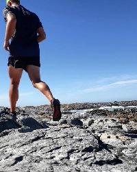
Adrian's Table Mountain trail running chronicles


Today, up India Venster, down to Echo Valley and along and up Smuts Track to Maclears, along the front face, down Platteklip (which was very slippery) and along the contour back to the cable station. It was misty and chilly. Starting at 13 degrees but felt decent heading up. The top was windy, with some slight rain at stages and cold. All in all, a fast climb up after which I slowed right down around Fountain Ledge to keep the heart rate lower and just idle along.
13.2 km
981 m of ascent
Halfway up India Venster.
Looking back down India V.
There is some scrambling. Take care. A few people have been killed further up where the stainless staples are now. Although they have made it far safer, someone was paralysed about 2 years ago. Go slow.
Kloof Corner on the right, looking down to Camps Bay.
Looking south towards the Twelve Apostles that are enveloped in the mist.
Down into Echo Valley the path is stable but beware the wooden sections in the wet...
Who can resist a selfie with the beautiful king proteas? I love these guys!
Up Smuts Track looking back. Also an old path that is seeing sign of wear and tear but quality stuff. Great technical running going down.
Looking down from halfway down Platteklip. An area I avoid unless it is raining or night time - too many people.
WATER! Understand that Cape Town is super dry at the moment. This is pure joy
")
Please login or register to view the images attached to this post.
Please Log in or Create an account to join the conversation.
And looking forward (west). This path is actually fairly technical. This section happens to be the flattest part shown in the pic.
Love the water

EDIT, map added:
Please login or register to view the images attached to this post.
Please Log in or Create an account to join the conversation.
6.5 km
441 m of ascent
351 m of descent
Map.
Zig zag seen on the other side of Rooikat Kloof looking north.
Looking south once through the valley.
And north towards town, this is the exit as it drops back down to the contour.
Please login or register to view the images attached to this post.
Please Log in or Create an account to join the conversation.
Please Log in or Create an account to join the conversation.

Coeta wrote: is running alone in that area not a safety risk?
Nope. I find driving on our roads far more dangerous.
Areas I don't like are:
- The Blockhouse near Devil's Peak. I went on a long run past there the day after someone was mugged. A chap was walking on a path below me wearing the exact same clothes as the mugger from the previous day. When he spotted me he upped his pace as our paths were to intersect ahead. I put down the hammer and heard shouting from up at Woodstock Cave presumably from his mates but no chance to get me. If I start in the dark I take pepper spray. I avoid the Block House area but had to train there in anticipation for Ultra-Trail Cape Town. This year is no different and I will return. I have never liked the area.
- I don't run near Hout Bay. And I would be wary of the Sandy Bay area too from what I've read.
- Silvermine has had issues at stages, I'm not certain which areas.
- Areas above Kalk Bay can be dodgy at times.
Many areas have had "issues" and incidents but I run in the same areas typically time and again, and have had no issues. To me, lower slopes are more dodgy in certain areas, ie. Hout Bay. Whereas hiking or running even at night on top is rather safe in my opinion. Muggers are lazy and they won't climb up high to attack you, typically. Generally I find trail running in Cape Town to be very safe. Yesterday at Constantia Nek it was buzzing with people, I think you'd be surprised as to the amount of hikers, dog walkers and runners on the slopes above the southern suburbs.
A chilling read about a mugger:
www.groundup.org.za/article/table-mountains-easy-targets-trail-hout-bay-mugger/
Please Log in or Create an account to join the conversation.
Saturday a short run with my wife. Started at Kloof Corner then up along the contour to Platteklip Gorge and back.
5.9 km
273 m of ascent
Heading up Kloof Corner. A brisk wind was blowing and it was around 14 degrees (without wind)
Please login or register to view the images attached to this post.
Please Log in or Create an account to join the conversation.
Up from Kloof Corner, along the contour, up India Venster, down into Echo Valley, up and then down into Valley of the Red Gods, down via Kasteelspoort and then back along the pipe track and then the small nail in the coffin is the short but steep climb back to the car. Did not feel good heading up India Venster but felt stronger later. Not my best performance but good to get out a bit. Had planned to do a 20 or 25 km but lost motivation quickly.
11.3 km
945 m of ascent
At the car I heard this weird scratching sound. A few second later I spotted this fella on a branch. They always amuse me.
Looking down to Camps Bay from Kloof Corner.
I had a late start (red wine I suspect!)
Light drizzle towards the end of the steep section of India Venster. It became quite cold once around 800 m ASL.
Behind me is the end of Platteklip. If you travel south you see this view as it drops into Echo Valley.
I love king proteas and always talk to them. People must think I'm mad. Maybe.
Echo Valley. People think Table Mountain is flat on top. It is not
Along the pipe track looking up randomly.
Please login or register to view the images attached to this post.
Please Log in or Create an account to join the conversation.
AdrianT wrote: Had planned to do a 20 or 25 km but lost motivation quickly.
I can relate on that one

AdrianT wrote: People must think I'm mad. Maybe.
Sanity is overrated

Please Log in or Create an account to join the conversation.
 Stairs are boring but effective in making myself stronger for running the Otter in October and the 65 km Ultra-Trail Cape Town in December. They are also "natural" stairs of course, not concrete. 12 degrees when I got there, the same when I left at 13:30 and almost no wind. Lovely day to train!
4.4 km
488 m ascent (16.3 kg pack and stairs only)
2 x 5 kg weights wrapped in a towel. Then another towel tossed in and a few other goodies to bring up the weight.
Final section before the contour. Then it's turn around and go back down.
Please login or register to view the images attached to this post.
Please Log in or Create an account to join the conversation.
10.1 km
726 m ascent
Cold, driving rain and wind
In the profile you can see Rooikat Kloof one way then the reverse route at the end. In the middle are those dreaded stairs. A real killer on UTCT.
Please login or register to view the images attached to this post.
Please Log in or Create an account to join the conversation.
