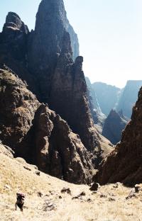
This pass follows a spectacular route up the Tseketseke River and gully alongside the Pyramid and the Column. Even though it has similar route details to Mlambonja Pass (see above), the upper grassy slopes are a lot steeper and make this pass feel as if it belongs in the Mnweni area. The beautiful river section and stunning views near the top make this a classic Drakensberg Pass.


Rating:
* * * (6/10)
Difficulty of the pass is rated from 1-10 (10 being very difficult, only to be attempted by the fit and experienced). A subjective quality rating is indicated by the number of stars (1 being low, 5 being the highest). Factors such as scenic beauty and overall experience come into play here, which may differ from person to person.

Access:
There are many ways to access Tseketseke Pass but the most direct route would be to hike up to the contour path via the “waterfall route” passing Doreen Falls, Albert Falls and Ribbon Falls and then to follow the contour path for 2 km to the right, descending to the Tseketseke River where the pass starts.

Details:
The distance from the contour path at the base of Tseketseke Pass to the top is 3 km with an altitude gain of 1000m.

Route:
Scramble up past the small waterfall where the contour path crosses the Tseketseke River and follow the intermittent cairns up the river. After about 1 km of boulder-hopping, a clear path veers off to the right (north) of the river and heads up the steep grassy slopes. The path stays on the northern slopes of the pass, climbing higher and higher, until about halfway up the pass. It then contours back to the river and climbs up the steep, small ridge which heads towards a huge boulder in the centre of the pass near the top. It’s simply a steep slog past this boulder and up the final grassy slopes to the top of the pass at 3000m.

Finding the pass from the escarpment:
There is a large gully heading down the edge of the escarpment to the right (southeast) of the Cockade. This is NOT Tseketseke Pass. Tseketseke Pass is a much smaller gully, a little further up the slope to the right (southeast) of this large gully. Just make sure you have the Column on your left when descending the pass and you will be in the correct gully.
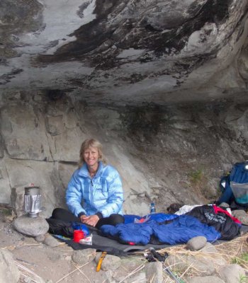
Overnight Spots:
Tseketseke Hut is a convenient (though very dilapidated) shelter on the Tseketseke River, 500m upriver from the contour path. It sleeps about 6 people. There is also a small campsite at the point where the contour path crosses the Tseketseke River. As usual, there is plenty of good camping on the escarpment.

Water:
There is a lot of water when boulder-hopping along the river for the first km or so but once the path leaves the river, some small trickles can be found in summer but otherwise the next water is in a river on the escarpment, 100m from the top of Tseketseke Pass.


There is a variation to the south of the main gully, which is described here:
www.vertical-endeavour.com/forum/drakenberg-passes-cathedral-peak/55897-tseketseke-pass-south-variation.html

Log in to comment


TheRealDave's Avatar
TheRealDave replied to: #78031 06 Oct 2022 21:41
If you wanted to go up and down Tseketseke, it would make sense to stay in Tseketseke Hut (gear would probably be fine in there, but you can never be too careful in SA). That would also be easier for the teens if they're inexperienced, as Xeni Cave to the top is quite an altitude gain and Cockade/Xeni are not the easiest passes, though Cockade is very beautiful.
Smurfatefrog's Avatar
Smurfatefrog replied to: #78021 03 Oct 2022 10:02
I would also suggest a loop with Cockade and Tseke, although if some kids are struggling going up and down the same pass would be better as they could wait back.
If you do head between Xeni cave and Cockade, boulder hop up the river bed rather than heading to the contour path which is quite overgrown

Xeni cave, it should be fairly safe to leave gear unattended there, but perhaps rather stash packs just around a corner from the cave
1armbandit's Avatar
1armbandit replied to: #78020 03 Oct 2022 09:32
 thanks appreciate the quick response.
I have done Cockade before and recall looking at xeni thinking that looks pretty dam steep!
I have not used Xeni cave in 15 years, does it need to be booked ?and would it be a terrible idea to stash gear and leave it unattended in the cave all day? or a farily safe option?  
 
BergAttie's Avatar
BergAttie replied to: #78019 03 Oct 2022 08:55
Yoru plan can work but I would rather go up Cockade or Xeni pass from Xeni cave since Tseketseke is quite a way south on the contour path from the Xeni cave valley. Leslie pass can also work but hard work with some bushwacking. Also - add about 1 hour to your drive in to Injasuthi compared to Cathedral.
1armbandit's Avatar
1armbandit replied to: #78018 03 Oct 2022 08:33
Morning all , looking for some advice. I have a group of teenagers i will be taking to the berg for a 3 day hike. I would like to show them a pass but as a day hike. 
I thought of using Xeni cave as a base for 2 nights and then doing a day hike up and down Tseketseke. I would appreciate comments o the feasibility of this idea. 
My alternative plan was Marble baths cave and a day hike up and down leslies.  

Any advice would be appreciated. 
 
GWTennant's Avatar
GWTennant replied to: #77741 01 Jun 2022 08:39
Hi All

Has anyone done Tseketseke Pass recently? Just looking for an update on its condition after all the rain...

Thanks!
Geoff
Wandelaar's Avatar
Wandelaar replied to: #77557 31 Mar 2022 12:03
I would just like to thank whoever went up or down Tseketseke pass in the last week or so. We had to exit a hiker with a bad knee and following your path through the vegetation really helped a lot! Especially near the top where there aren't any rock cairns. 

Regards,
Wandelaar. 
intrepid's Avatar
intrepid replied to: #76078 16 Sep 2020 18:47

ruthtbl wrote: There is a typo in this article I believe. Under 'Access' the article refers to Fangs Pass instead of Tseketseke Pass.

Thank you, this has been fixed.
ruthtbl's Avatar
ruthtbl replied to: #76076 16 Sep 2020 10:43
There is a typo in this article I believe. Under 'Access' the article refers to Fangs Pass instead of Tseketseke Pass.
mike_cromberge's Avatar
mike_cromberge replied to: #75463 15 Nov 2019 18:39
Hi Vicki, how did your hike go? I'm interested to hear about the current condition of Tseketseke pass as I'm planning on going up over the long weekend in December.

Does anyone have a GPS track of this route? :)

  
Riaang's Avatar
Riaang replied to: #75244 12 Aug 2019 11:02
Here Herman was going the wrong way, i.e. carrying up the pass instead of going onto the bank on the right side as you ascend. I had to call him back and he then climbed back down onto the flat rock where I was standing.


This is the section of flat rock. Where I am standing you will find a cairn showing you where to climb onto the bank.
 
Riaang's Avatar
Riaang replied to: #75243 12 Aug 2019 10:58
Hi Vicky,

Let me be the optimist and say that your route selection per day is very doable and achievable. I normally take Berg newbies on this exact same route, or around to Twins cave and down via Mlambonja pass. Getting over Elephant/Mahout is a bit easier on tired legs than tackling Cleft peak and Ndumeni dome.

I would advise starting early, so you can get a good section of the pass done before it gets too hot.

Also, if you can get a track of the route and download it on your gps. There is a place where you need to exit out of the riverbed, if you miss this spot you will be having an adventure :-). Best way I can describe it is as follows: After about 1,7km's from the hut you will get to a section where there is a 3m high waterfall (if the river is flowing). Fairly large rocks lying around. There are cairns leading you onwards in the riverbed, but here you need to get onto the bank on the right hand side (as you are ascending). You will notice a flattish rock to your left if you turn around and look down towards the hut (which you won't be able to see from this point as it is around the corner). On the right side of the river (still looking down the valley) you will notice a couple of large, dead, pine trees about oh, 300m or so away. 

The dodgiest section for me follows soon after this, where you walk close to the edge about 15m or so above the riverbed (on your left). These side banks could very easily break off and fall down into the river. I normally hurry through this section, only about 30m long. Hereafter it's up and down over little side gullies, pretty steep until you get to the scree field at around 2550m. From here it is a real slog for about 300m (I ALWAYS struggle with this section!!!), then just the finall grassy secttion to the top. Hop over and about 200m down you will find a stream with water. Go left for Rolands, right for Twins.
elinda's Avatar
elinda replied to: #75233 08 Aug 2019 18:43
Hi Vicki

I would agree with Smurfatefrog - rather take your beginner hikers on an easier route.  In my personal opinion, Tseketseke pass is not that easy and is also full of loose rocks which can be dangerous, especially if hikers are not experienced
Smurfatefrog's Avatar
Smurfatefrog replied to: #75232 08 Aug 2019 15:14
Hi Vicki, 

The question is more about fitness than being a beginner.
A few weeks ago I took a fairly experienced (although not with berg passes) hiker this same route and after taking 4 hours from the contour path to half way up Tseketseke pass we decided to head back down to the hut.

Tseke pass is of average difficulty as far as berg passes go, probably quite comparable to Camel

So personally I'd take them on a warm up hike locally with lots of hills to test their fitness
Vicki's Avatar
Vicki replied to: #75231 08 Aug 2019 15:03
Hi, please can someone tell me if you think beginners would handle this potential route:

Day 1: hiking from Cathedral Hotel up the waterfall route, to Tseketseke Hut. Sleeping there on the first night.
Day 2: Hiking up Tseketseke Pass the next morning, across the top of the escarpment to Rolands Cave. Sleeping there.
Day 3: Hike down the Camel route to the hotel.

I have done the Camel to Rolands, but have no idea how difficult Tseketseke would be for beginners... Thanks!
GerritHuman's Avatar
GerritHuman replied to: #73196 12 Apr 2018 20:58
Wow it is a rare find to have photos of passes nearly 10 years apart.
Thanks for looking for the old photo and sharing it!
Riaang's Avatar
Riaang replied to: #73137 06 Apr 2018 20:15
Would be nice if that could happen at Ships Prow :-)
Spoke101's Avatar
Spoke101 replied to: #73126 05 Apr 2018 22:05

tonymarshall wrote: As the fun part of the VE Berg Trip 2, Intrepid, diverian and tonymarshall did a day trip up and down Tseketseke Pass, combined with felling and ringbarking pine trees in the upper Tsekeseke valley.

The previous day we departed from the hotel hikers parking area, past the stables and into the Tseketseke valley past the Blue Pools. Even low down the valley, there was evidence of flash flood damage from the March 2011 flash flood in the Tseketseke catchment.

We were to stay in the river bed the whole way to the Tseketseke Hut, our overnight spot (except for several detours out of the river to cut pine trees.) Near a large copse of pine trees which we tackled, spectacular views of the Camel, Organ Pipes and Castle Buttress were afforded from the bank above the river. Note the lone pine tree to the right in the photo.

As we approached the Tseketseke Hut from downstream, it was apparent how close the hut (in the centre of the photo below) had come to being destroyed in the flash flood, with the erosion adjacent to and downstream of the hut leaving it on an island.

Below is a view of the upper Tseketseke and Tseketseke Pass from the contour path, with Cleft Peak, Column and Pyramid dominating the skyline.


The next morning we headed upstream, and not far from the hut caught the first sight of the top of the valley and pass. It was to be a day of more boulder hopping.

We stayed in the boulder bed until about 2550 m where we found a trail on the left (southern) bank which followed the grass slope to the top of the pass at 3000 m. A view down Tseketseke Pass.


First post here, and thought I'd revive an old thread. Really found this pic interesting because I have great memories of coming down Tseketseke in late 2008 so I decided to do some digging and found this gem of a pic taken form nearly the same spot. The two pic's show resulting effect of the flood on the pass.

Riaang's Avatar
Riaang replied to: #72520 27 Dec 2017 12:14
Easy or difficult is of course very relative (dependent on things like fitness levels, experience, temperature, weather etc.), but for the sake of benchmarking, we took a complete novice hiker (who was very unfit) up Tseke pass earlier this year, in perfect weather, and he completed it in 3h45min, so in my opinion a day seems overly conservative. In mist it would take longer and route finding could be a bit more tricky, but as stated there is a "path" on the true left (on your right as you ascend the pass). It starts at the bottom waterfall section, and you climb out of the river bed and onto the enbankment.

There is definitely a few dodgy places on this route, on one particular section you walk very close to the edge and should the ground give way (it is unstable close to the edges, especially when water logged) then you are in for a nasty slide down the walls into the riverbed about 20m or so below.

I found Tseke to be a really nice pass, lots of varied terrain to keep things interesting with a grassy section the last 300m or so to the top. Unlike something like Ifidi which has miles of rock hopping right to the top, and 3 climbing sections to boot in the last 100m to the top of the pass.

Other than the timeframe allocated for this pass the lessons learnt are all very valid points. Fully agreed on the lack of clear paths here. Last hike here a few months ago was in the mist and if you don't know where to go or don't have a gps track then climbing out of the riverbed it is difficult to see the path. Is it just my imagination or are the paths in the (especially lower) berg becoming more overgrown? Did a hike in Moncs Cowl 2 weeks ago and on the North side of Newmans' ridhe there were long stretches where the contour path is completely overgrown. Would be interesting in the mist.........
TheRealDave's Avatar
TheRealDave replied to: #72516 24 Dec 2017 13:50
Tseketseke is not an easy pass, but, for general reference, please note that, after the riverbed, there is a path which begins on the right-hand side (true left) and goes all the way up, as described in Tony's write-up here . As with similar passes such as Leslie's and Ship's Prow, the rocky riverbed requires care and some independent navigation, though, as far as I remember, there are cairns at all the critical points. Tseke can be done in half a day (6 hours or less) if you're relatively fit.
brettross32's Avatar
brettross32 replied to: #72513 21 Dec 2017 12:37
We have just completed Tsekitseki pass top to bottom. A few points worth noting. The grass section even though steep was very managable and required good balance and trust on boot grip. The first rock section can be misleading with few markers. We went left (north side) only to find a shear drop off. We traversed right approximately 20m and found a trail with markers and headed into the river rock section. Beware of staying or descending next to embankments. One of our tream was lucky to get away with just a bruised thigh when she dislodged a boulder with her hand. Rocks are unstable in the river section and all 5 of our group lost balance and fell a few times down the pass.
About 500m from the hut the markers run out but keep going down till you reach a timber cross marker and the stone markers re appear. From the hut to the path connecting to the contour path is about 500m just past the collapsed river bank on the south side of the river bed. Look for the stone markers leading to a cleared camp area in the bush. Worth noting is more than one path leading off through the bush. These paths are very over grown and it is important that you dont select the wrong path and get lost walking in circles. Spend a few minutes checking out which track is the right one before dragging the while group with you.

Lessons learned.
Take enough drinking water from the top to last for at least 3 + hours.
Don’t under estimate the time it will take to do this pass (one day from the top to the little berg is a safe estimate )
Concerntrate on your foot positions. Nothing is stable and minor falls could result in a twisted ancle or worse.
Stay together as a group within visual sight.
Our 10m rope came in handy when we needed to drop our packs over a steep section rather than climb down with packs on your back.

We have done Shipsprow pass more than 21 years ago, but having done this pass (even though way shorter and less height drop) rates well up there as one of the toughest and demanding decents I have done with a full load. Don’t attempt this if you are not physically and mentally up to the challenge. The views of the rock spires and cliffs around the pass are spectacular but know the price you need to pay in blood sweat and tears when attempting this pass
tonymarshall's Avatar
tonymarshall replied to: #65158 21 Sep 2015 06:59
The trail crosses the stream at S 28° 59.537 E 29° 09.962 to the true right, and in the photo below the group can be seen ascending from the stream crossing on the left (true right) of the stream.


The photo below is taken from the same point as the previous photo, back downstream to the stream crossing. When heading upstream the crossing is very obvious, but when heading downstream it is not so easy to find, and there is a bit of a false trail staying on the true right, so look out carefully for the correct trail.


The trail keeps to the true right up to the top of the pass, with several zig zag sections.


The top of Tseketseke Pass with the distinct trail.


A gps map of the route, showing the salient points, with our track of the pass descent.

tonymarshall's Avatar
tonymarshall replied to: #65157 21 Sep 2015 06:56
Further to the previous two pages or so of posts relating to the Tseketseke Pass trail, during the VE Berg Trip 7 on the last weekend in August, six VE members, intrepid, Andrew P, Viking, smurfatefrog, Lorinda and tonymarshall, part ascended (we summited via Tseketseke Pass South variation) and descended Tseketseke Pass, taking particular note of the trail on the pass.

We had walked in up the Tseketseke valley the previous day, past the Blue Pools. There is a trail from the turnoff up the Tseketseke valley from the main path to Mlambonja Pass, up the Tseketseke valley to the vicinity of the Blue Pools. Further upstream the trail vanishes, but it is easy enough to boulder hop on the boulders of the stream bed. This is necessary all the way upstream to the Contour Path crossing of the Tseketseke River, and further upstream to the Tseketseke Hut.

Upstream of the Tseketseke Hut there is a trail developing in the wide boulder bed of the river, but if you miss it just keep following the boulder bed upstream. The developing trail isn’t strong and comes and goes a lot. Heading upstream, a small remaining cluster of ring barked dead and dying pine trees is visible on the left (true right) of the stream, and it is necessary to stay in the boulder bed to just past this cluster of pine trees before the pass trail begins. The pine tree cluster is approximately 1 km upsteam of the Tseketseke Hut, and the beginning of the trail about 100 m upsteam of the pine tree cluster.

Since our group ascended and descended the trail, I have combined photos below from both directions to show the detail of the trail, although I will describe the route heading upstream up the pass.

We took a break where the trail starts, and filled up with water as the trail leaves the stream here and the stream was dry when we crossed it again higher upstream (although in summer there should be water at the upstream crossing). The photo below shows the gully exit from the stream, at the start of the trail on the right (true left) of the stream, with the exit from the stream bed at the right of the photo. The gps co ordinates of the stream exit to the trail are (WGS84) S 28° 59.540 E 29° 10.059 at 2255 m. The stream exit is marked with cairns.


Just upstream of the trail exit, looking back downstream to the pine tree cluster, which is a useful marker to judge the position of the trail exit. We have ring barked all of the trees now, so hopefully they will soon all be dead.


The group heading up the trail on the true left.


Higher up the trail with Column in the background.


Further upstream the trail comes back into the stream bed as the stream crossing is approached.

ghaznavid's Avatar
ghaznavid replied to: #63690 08 May 2015 21:32
Just a thought - Hi-Tec just got me to fill in a survey for an article they are writing. My response to one question was that people often use a standard gear list, but often don't know how to use the gear. A classic example of this is a space blanket, and there is a detailed thread where AndrewP shared some gems about how to survive an emergency bivy. A thread on how to set up a backup belay off limited gear might be useful as well.

This is what I did for the belay shown above - I would like feedback from the climbers on the forum as to the correctness of my technique:
1) I tested the only suitable rock by giving it a good kick, push and seeing if I could get it to budge in any way. It was solid
2) I used a triple fishermans knot to make a loop in the end of my rope.
3) The rock didn't have any form of catch to get the rope around, there was a small notch in the rock which held the rope in place, so this was used.
4) Before anyone went, I pulled down with all my weight on the end of the rope to see if the knot and rope placement was solid. It was.
5) I tied the other end of the rope into a rope harness. I would usually use a sling, but didn't have one on this occasion.
6) Everyone was instructed not to fall as the system would only stop them from hitting the ground, but a rope harness will give you a monster wedgy!
7) After the rope harness was put onto the first person, a locking biner and belay device was attached to an overhand knot tied just past the anchor (if put through the loop, a fall would just pull the loop around the rock loose). Standard belay procedure was followed (with the normal command words).

No one fell, so the system was never tested, but I rate this precaution was necessary. A watercourse can be slippery...

I rate that a few sessions at a climbing gym is a good idea for all hikers. Even if just to learn some basic knots, how to belay and also how to secure an anchor (although that would be best learned at a crag).

A harness can be improvised on the end of a rope, although a sling is slightly better (I have abseiled off a sling improvised harness once, it was painful, but did the trick). A munter hitch can be used in place of a belay device. But, to the best of my knowledge, you can't get away without a caribiner. And the biner must always be a locker as ropes do funny things when you load them!

Important notes on gear:
- Don't use hardware biners, only use climbing biners which you buy from a climbing shop.
- Only use locking biners.
- The rope you use must be suitable for a belay device. "Outdoor rope" as sold by Mr Price Sport/Dischem etc doesn't bite on a belay device and isn't rated to stop a fall. Buy this from a shop that sells climbing gear and make sure the salesperson does climbing themself before you take their advice. I often hear "I'm sure it's fine" or "of course it will work for that" from people who have no clue what they are talking about. I personally will only buy the rope I use for things like this from either Bush 'n Bundu (with Cesar as the salesperson) or Mountain Mail Order (which is a climbing gym) and with them confirming that it is suitable for improvised abseils or belay.
- I use 8mm access chord for this. This is rated to take a large amount of weight, but is not a climbing rope, so it isn't designed to take falls.
- Never buy rope second hand. If it takes a major impact, inspect it before using it again. If it takes a few big impacts, replace it.
- Replace it every 5 years
- You need 20m of rope for a relatively short belay. 20m sounds like a lot, but the harness uses 2m, the anchor could easily use 5m if it is a big solid rock and could easily be 5m from the obstacle. If it is 10m or higher, you really shouldn't be using a system like this, so more than 20m is probably overkill.

As mentioned above - I would appreciate feedback on the above from the guys who are more experienced with these kind of system.
andrew r's Avatar
andrew r replied to: #63679 08 May 2015 12:49
Good pic; the bank on the true left of the steps we came down is very loose and the waterfall is likely to change again with the next significant rain, especially if it undercuts the large overhead boulder. This is probably irrelevant, as it seems that the high-route on river-left used by DeonS and others is the way to go as it skirts both waterfalls.