
Fangs Pass
16 Feb 2010 07:16 - 14 May 2015 19:29 #58852
by Stijn
Read more...
edit: Trip report www.vertical-endeavour.com/forum/drakensberg-trips/55788-fangs-mbundini-loop-the-dragon%E2%80%99s-teeth.html
Fangs Pass was created by Stijn
In most hikers’ opinions, this is the most spectacular and enjoyable pass in the Mnweni area and even the entire Drakensberg. Navigation in the pass itself is relatively easy despite the lack of a path and this lets you rather admire the awesome pinnacles, towering buttresses and the never-ending view of the Mnweni little berg stretching beneath you. This pass is a definite must for any hiker who ever gets a chance to explore the area.
edit: Trip report www.vertical-endeavour.com/forum/drakensberg-trips/55788-fangs-mbundini-loop-the-dragon%E2%80%99s-teeth.html
Last edit: 14 May 2015 19:29 by Smurfatefrog.
Please Log in or Create an account to join the conversation.

17 Apr 2012 18:14 #53593
by tonymarshall
Replied by tonymarshall on topic Fangs Pass
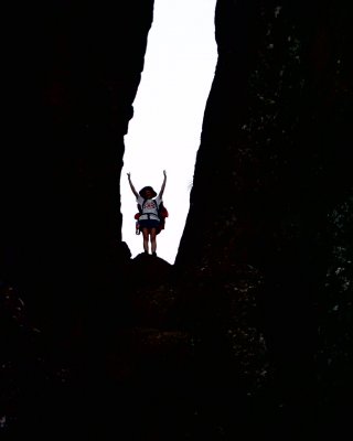
Over the Easter weekend we descended Fangs Pass after our epic ascent of Ifidi Pass.
The pass has steepish grass slopes at the top and very good views of the Mnweni Needles.
A view up to the top of the pass on the grass slope.
Descending, the grass slopes slowly give way to scree and boulders.
The valley narrows and the route is restricted into the boulder bed.
The boulder hopping starts and progress is quite slow.
Please login or register to view the images attached to this post.
Please Log in or Create an account to join the conversation.
- tonymarshall
-

- Offline
- VE Advisory
-

Less
More
- Posts: 768
- Thank you received: 2233
17 Apr 2012 18:39 - 17 Apr 2012 18:44 #53594
by tonymarshall
Replied by tonymarshall on topic Fangs Pass
Lower down the gradient becomes flatter, and the tree line is reached. The top of the pass with the grass slope is visible as the low point in the background.
The top of the pass is the left hand grass slope in the background.
A view to the Fangs from the river bed.
The waterfall in the river is the point where the path to Mbundini meets Fangs Pass. Madonna and Her Worshippers are visible about a third in from the right of the photo, and Mbundini Abbey is the high point at the right.
We headed down river, relieved to be past the boulder hopping and on a path, and overnighted at Five Star Cave, before walking back out to Mnweni Cultural Centre the next morning. For a more detailed description, see Elinda's or mykitchin's write ups under the topic 'Fangs to Ifidi...or vice versa.'
Please login or register to view the images attached to this post.
Last edit: 17 Apr 2012 18:44 by tonymarshall.
Please Log in or Create an account to join the conversation.
- tonymarshall
-
- Offline
- VE Advisory
-
Less
More
- Posts: 768
- Thank you received: 2233
22 Oct 2013 07:48 #58853
by chan5aard
Replied by chan5aard on topic Fangs Pass
We came down the pass this year January. The rocks took heavy strain on our knees and quads but it definitely is a beautiful pass. I would say definitely don't underestimate the difficulty. It's hard.
Please Log in or Create an account to join the conversation.
24 Apr 2023 21:38 - 24 Apr 2023 22:07 #78481
by tonymarshall
Replied by tonymarshall on topic Fangs Pass
For many years I have heard talk of a path in the lower section of Fangs Pass, that goes off from the path up Mbundini Pass, and follows the true left bank of the stream coming down from Fangs Pass, before ending at the stream. On the last time I did Mbundini Pass, we saw the path going off from the Mbundini Pass path, but on all the previous times I had done Fangs Pass, I had missed the path.
In August 2022 AndrewP, ghaznavid and tonymarshall went up Fangs Pass, to climb the Mbundini Molar, and Mbundini Fangs. We used the stream approach at the bottom of Fangs Pass, and once higher up the valley looked back down the valley, and could see the path below. I was determined to get onto this path and use it when we returned back down the pass. That night we found a flattish spot to camp about 300 m upstream of the Fangs – Madonna Pass junction, and being good weather we just bivvied there in the open without using our tents, as the area was too small to pitch our tents. We left our packs at this spot, and continued the next day up the pass with day packs with our climbing gear, going up the gully past Fangs Cave, and arriving onto a very windy summit. We went around to the start of the climb, but it was just too windy, and sadly we didn’t get to do any climbing. As it was early when we returned, I suggested that we try the gully to the north of Fangs Pass, which I had also wanted to try for a long time, and we went down this parallel gully, and had lunch near where this gully and the main gully join. Downstream we collected our packs, and continued on, looking for the elusive path. Lower down we saw the path below us, but didn’t see where the path joined the stream which we were following, boulder hopping, and I concluded we had passed the spot where the path joined the stream. At the first opportunity, I exited the stream on the true left, and soon found the path, and calling the others, we used the path to the junction with the Mbundini Pass path.
The photo below, from my earlier 2012 post, shows the Fangs Pass north gully relative to Fangs Pass.
A view to the top of Fangs Pass north gully from near the top.
A view down Fangs Pass north gully.
Conditions in the gully are quite similar to the parallel section of Fangs Pass, and the views from the gully are equally good, or even better.
Lower down a huge section of rock had broken off a tower on the true right, and the boulders and debris were strewn down the gully, over a long distance. This didn’t really make hiking difficult, we could cross the rock and debris easily, but it will be a while before some of the larger boulders stabilise, and I would expect the debris to keep moving down the gully, especially in the rainy season.
The photo below shows the path at the lower section of Fangs Pass, on the true left bank just upstream of the Fangs – Mbundini junction. The path can be seen on the slope at the left of the photo, in the shadow and sunlight, with the Mnweni Needles in the background.
I include a map with some gps tracks and waypoints to show where the path is. The blue track is the path of Mbundini Pass, the magenta track is the way we walked in to Fangs Pass, splitting off the Mbundini Pass path at my waypoint P J Mn 27 (Path junction at Mnweni number 27 not marked on the hiking maps) before following a short piece of path along the stream and then boulder hopping, and the red track is the way we walked out, using the path.
So the path at the lower section of Fangs Pass is the portion of red track, from the split with the magenta track near the left of the map, to the path junction U14. Although this way uses a steepish section of the path at the bottom of Mbundini Pass, the path itself from U14 to the stream of Fangs Pass is quite flattish, and easy to follow, with no bushy areas. This makes quite a difference as it saves some 300 – 400 m of boulder hopping in the stream.
The relevant gps coordinates (my waypoints, WGS84) are:
U14 S28° 51.473' E28° 58.166' at 2105 m
P J Mn 27 S28° 51.474' E28° 58.308' at 2030 m
Fangs Mbundini Waterfall S28° 51.482' E28° 58.383' at 2015 m
Unfortunately I didn’t get a waypoint of the point where the path joins/leaves the stream, having missed this point, and got onto the path a short way downstream, and didn’t think to walk back along the path and save a waypoint, but it is at about S28° 51.503' E28° 57.918' at 2145 m.
After taking an afternoon break at the Fangs Mbundini Waterfall where the path crosses the stream, we continued downstream on the path along the Mbundini River, and overnighted in Five Star Cave before we walked out back to Mnweni Cultural Centre the next morning.
Please login or register to view the images attached to this post.
Last edit: 24 Apr 2023 22:07 by tonymarshall. Reason: Correct formatting
The following user(s) said Thank You: elinda, DeonS, tiska, firephish, ghaznavid, hikingle, Smurfatefrog, supertramp, Riaang, andrehayward
Please Log in or Create an account to join the conversation.
- tonymarshall
-
- Offline
- VE Advisory
-
Less
More
- Posts: 768
- Thank you received: 2233
