
Malealea to Semonkong
24 Mar 2012 18:30 #53294
by Biggs_ZA
Malealea to Semonkong was created by Biggs_ZA
I would like to hike in Lesotho from Malealea Lodge to the Maletsunyane waterfall at Semonkong. Please share with me any information that you might have on this hike.
Apparently there exists a set route, but I'm struggling to find any resources that indicate the path (I realise one can walk more or less anywhere, but still). On Google Maps I've calculated a route that basically follows the river from Malealea to Semonkong and it will result in a three day hike.
Thanks in advance.
Please Log in or Create an account to join the conversation.

27 Mar 2012 18:24 - 28 Mar 2012 05:02 #53324
by intrepid
Take nothing but litter, leave nothing but a cleaner Drakensberg.
Replied by intrepid on topic Re: Malealea to Semonkong
On my 1:250 000 Lesotho map it shows a trail from Malealea to Ribaneng village then along the Ribaneng River, past the falls, crossing over the first range and then on to the Ketanyane River. Then there is a split. You stick the Northern fork which takes you through Ha Mothibi village, after which you cross over another range and then down into Semonkong. The 1: 50 000 survey maps will show some trails too. I have the Semonkong plate (2928CC) but it only shows the last little bit and is not much use. You need the 2927DD plate, which unfortunately I am missing.
What about asking the owners of Malealea Lodge, they should be more than knowledgeable. They themselves offer pony treks to Maletsunyane via the Ribaneng Falls.
What about asking the owners of Malealea Lodge, they should be more than knowledgeable. They themselves offer pony treks to Maletsunyane via the Ribaneng Falls.
Take nothing but litter, leave nothing but a cleaner Drakensberg.
Last edit: 28 Mar 2012 05:02 by intrepid. Reason: typo
Please Log in or Create an account to join the conversation.

28 Mar 2012 17:21 #53351
by Biggs_ZA
Replied by Biggs_ZA on topic Re: Malealea to Semonkong
Thanks for the information Intrepid. Where did you buy your Lesotho maps? I had a look at Exclusive Books, but the InfoMaps and other maps they had in stock aren't worth much for hiking.
I emailed Malealea and they referred me to www.malealea.co.za, because the "map of the route is on there." It turns out to be just waypoints on Google Maps, so at least I know where to end every day, but not quite how to get there. At least it is a start.
I printed some terrain maps on Google Maps today and will try and figure out a way tomorrow as I plan to hike it from Saturday morning.
Regarding the safety and accommodation: Malealeaa said that if you travel with your own tent, you can sleep close to/in the villages and pay the chief R35 per night. They say they have never had any security issues because they have a standing arrangement with these villages for their overnight pony trekking tours. You can, alternatively, take a guide from Malealea at R150 per day and pay his transport from Semonkong back to Malealea. That amounts to a hefty price around R500.
But thanks again for your post. It is by far the most useful information that I have encountered in looking for a route.
Please Log in or Create an account to join the conversation.
29 Mar 2012 12:07 #53359
by intrepid
Take nothing but litter, leave nothing but a cleaner Drakensberg.
Replied by intrepid on topic Re: Malealea to Semonkong
The maps are from the government survey people in Maseru. The contact person used to be Victor at This email address is being protected from spambots. You need JavaScript enabled to view it.
I have emailed you a scanned copy of the route from the 1:250 000 map.
Contacting the chief in the villages is a very sensible practise. They will also be able to assist if you have any issues and should be able to give directions. Who knows, some of the kids or shepherds will accompany you through certain sections, especially where there are lots of trails splitting off in different directions.
Enjoy and let us know how it goes!
Take nothing but litter, leave nothing but a cleaner Drakensberg.
Please Log in or Create an account to join the conversation.
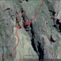 the Camels Back" title="Around the "Bad" section of