
Twins Pass
09 Nov 2018 14:09 - 03 Aug 2020 19:00 #74197
by tonymarshall
Twins Pass was created by tonymarshall
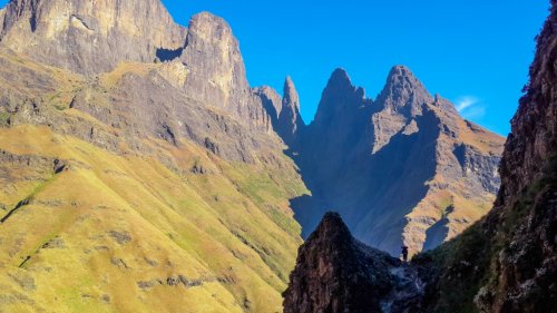
After my ascent of Scramble Kop Ridge and the Bell Traverse, and overnighting in Twins Cave, Twins Pass was the next pass I did. In the photo below, taken from the Bell Traverse path on the daybefore I descended Twins Pass, the pass is the gully to the right of Twins and Twins Cave, going down immediately below Twins Cave.
I am only aware of one recorded use of Twins Pass, by Reg Pearse, and described in his book Barriers of Spears. In all three editions it is in Chapter 5, towards the end of the chapter in the diary entry for Wednesday October 8, 1947. Pearse writes “I had left Twins Cave at 7.15 am, again with a heavy pack, and had entered what was new country to me, with only a map to guide me. I headed straight down from the cave into the valley below, five thousand feet, taking it easily, and reaching the bottom in a couple of hours. Then a pleasant walk of an hour over gentle grass slopes brought me to the caves.” The caves he refers to are what we know today as Waterfall Cave, although previously they were known as the Ntonjelane Caves. So the use of Twins Pass was described, without the pass being referred to by any name or in detail.
It is quite likely that over the years Twins Pass has been used by many people, and even possibly again by Pearce. Although not much is known about Twins Pass, it is visible from the Bell Traverse, and from near Twins Cave you can look directly down the pass. The photo below (from March 2015) shows the view of Twins Pass from Twins Cave.
I had also been able to look up Twins Pass in April 2015 on the approach to Christmas Pass in the valley below, from which it could be seen that there was quite a high waterfall in the stream, but with an adjacent grass slope bypass.
From the various views of the pass, and the lack of any mention of obstacles in Pearce’s description of the route, it seemed that Twins Pass was doable without too much difficulty either by following the valley or the adjacent ridge. I had decided that I would
follow the stream and valley, and was about to find out.
Please login or register to view the images attached to this post.
Last edit: 03 Aug 2020 19:00 by tonymarshall. Reason: Correct formatting
Please Log in or Create an account to join the conversation.
- tonymarshall
-
 Topic Author
- Offline
- VE Advisory
-

Less
More
- Posts: 768
- Thank you received: 2233
09 Nov 2018 14:13 - 09 Nov 2018 14:28 #74198
by tonymarshall
Replied by tonymarshall on topic Twins Pass
Departing from Twins Cave as Pearce had done seventy years ago, I was soon heading down the upper grass slope section of the pass. Unfortunately the early morning light didn’t make for fantastic photos.
A view back up the upper grass section of the pass as the terrain became more rocky.
The sides of the pass closed in lower down, and the valley became a small gorge. It was still not difficult terrain to walk on. In the photo below the peak at the left on the horizon is South Saddle.
The stream had flowing water from about 2650 m altitude, and a bit lower down there was a minor obstacle to scramble down.
A view back upstream from the small gorge, showing the typical boulder bed and sparse bush in this section of the pass. Twins peak is in the background of the photo below.
Soon the view downstream showed that I was close to the top of the waterfall.
The view down from the lip of the waterfall, with the expected opening of the valley below the waterfall visible in the background.
After descending the grass slope on the left (true left) of the waterfall (on the right in the photo below looking upstream), I had this view back to the waterfall.
Please login or register to view the images attached to this post.
Last edit: 09 Nov 2018 14:28 by tonymarshall.
Please Log in or Create an account to join the conversation.
- tonymarshall
-
Topic Author
- Offline
- VE Advisory
-
Less
More
- Posts: 768
- Thank you received: 2233
09 Nov 2018 14:20 - 09 Nov 2018 14:35 #74199
by tonymarshall
Replied by tonymarshall on topic Twins Pass
Downstream of the waterfall the gradient of the valley was a lot flatter.
The terrain was still mostly boulder bed, as can be seen in the upstream view of the photo below.
As the valley widened, I looked for an easy way out of the boulder bed onto the adjacent flattish grass, and would leave the boulder bed just behind the tree at the centre of the photo below.
Walking on the grass terrace next to the stream was a lot easier, especially with the short grass.
After several hundred metres of walking downstream on the grass terrace, I got onto the path, which came up the valley on the true left from the stream crossing at the bottom of Ntonjelane Pass, where this path branched off the main Ntonjelane Pass path.
A view back up the valley, showing that it would also be possible to use the ridge across the river instead of the valley as a route of Twins Pass. Several of the adjacent valleys would probably also be alternative routes. In the photo below, the jagged peaks in the background are The Chessmen.
The path goes past a small shelter near the river, which was relatively clean compared to when I had seen it in 2015 on my way to ascend Christmas Pass.
Locals use this shelter, although it obviously hadn’t been used in a while since the grass fire had burnt the grass cover on the floor.
I continued along the path downstream, just over a kilometre until the junction with the main Ntonjelane Pass path, where I took a mid morning break at the river. Just as Pearse had described it, a couple of hours to the bottom from Twins Cave. After a good break, I headed left up the ridge on the path of Ntonjelane Pass, on my way to ascend Ntonjelane North Pass.
Please login or register to view the images attached to this post.
Last edit: 09 Nov 2018 14:35 by tonymarshall.
The following user(s) said Thank You: diverian, elinda, Stijn, JonWells, firephish, ghaznavid, Smurfatefrog, ASL #Bivak, AndrewP, Riaang, Papa Dragon, TheRealDave, GriffBaker, WarrenM
Please Log in or Create an account to join the conversation.
- tonymarshall
-
Topic Author
- Offline
- VE Advisory
-
Less
More
- Posts: 768
- Thank you received: 2233
15 Nov 2018 16:09 - 15 Nov 2018 16:10 #74206
by Len1972
Replied by Len1972 on topic Twins Pass
Thanks Tony, nice review of the pass.
Lenard
Lenard
Last edit: 15 Nov 2018 16:10 by Len1972.
Please Log in or Create an account to join the conversation.

31 Jan 2024 13:30 - 31 Jan 2024 13:48 #78875
by supertramp
Replied by supertramp on topic Twins Pass
In our endeavour to continue exploring our beloved Drakensberg, Twins Pass has suddenly popped onto my radar. From Tony's write-up, I can see that there may be a few alternatives worth considering. Does anyone have a gpx track and/or some advice you won't mind sharing?
Our itinerary allows for either an ascend or descent. Thanks!!!
This image is hidden for guests.
Last edit: 31 Jan 2024 13:48 by supertramp.
Please Log in or Create an account to join the conversation.
- supertramp
-
- Offline
- Elite Member
-

Less
More
- Posts: 225
- Thank you received: 455
13 Feb 2024 20:36 #78893
by supertramp
Replied by supertramp on topic Twins Pass
Tony was so kind to provide me with the track and excellent advice, thanks Tony!!!
We are going to the Berg this weekend and have decided on the following route:
We are going to the Berg this weekend and have decided on the following route:
- Saturday: MCC - Twins Pass - Billy Cave
- Sunday: Down Rockeries or Ntonjelana Pass back to MCC.
The following user(s) said Thank You: tonymarshall
Please Log in or Create an account to join the conversation.
- supertramp
-
- Offline
- Elite Member
-
Less
More
- Posts: 225
- Thank you received: 455
13 Feb 2024 21:16 #78894
by Smurfatefrog
Replied by Smurfatefrog on topic Twins Pass
We might see you at MCC!Tony was so kind to provide me with the track and excellent advice, thanks Tony!!!
We are going to the Berg this weekend and have decided on the following route:
- Saturday: MCC - Twins Pass - Billy Cave
- Sunday: Down Rockeries or Ntonjelana Pass back to MCC.
Please Log in or Create an account to join the conversation.
- Smurfatefrog
-

- Offline
- Moderator
-
Less
More
- Posts: 1132
- Thank you received: 1550
14 Feb 2024 09:23 #78895
by supertramp
Replied by supertramp on topic Twins Pass
That'll be epic! Hope to see you there!!! We should arrive on Friday at about 7 pm and start hiking on Saturday morning at around 6AM.We might see you at MCC!
Please Log in or Create an account to join the conversation.
- supertramp
-
- Offline
- Elite Member
-
Less
More
- Posts: 225
- Thank you received: 455
06 Apr 2024 12:47 - 06 Apr 2024 12:58 #78989
by supertramp
Replied by supertramp on topic Twins Pass
Over the weekend of 17 & 18 February 2024, my wife and I did a Twins(ascent) and Rockeries(descent) pass loop in the Mnweni area. Tonymarshall’s excellent write-up and track provided everything we needed for our ascent of Twins Pass.
The intent of this write-up is just to provide an update on Twins Pass and to share a few of our lessons learned.
We started hiking from MCC at 05:45AM and reached the Ntonjelana Pass Junction at 10:15AM (±13km, “road of empty dreams” gravel road included). We used the standard route approach on the western side (true left) of the Thonyelana mpumalanga river. It is worth noting that we were quite surprised by how overgrown this section has become (in comparison to previous visits) and by judging by the state of the path as well as observing the herdsmen and cattle movement, it appears that the path on the eastern side (true right), indicated in light blue in the image below, has become the more preferred option.
The image below just showcases the beauty of the approach, with the Cathedral Peak and Bell Traverse route in the background.
After turning left at the Ntonjelana junction and looping around to start our approach to Twins, we encountered a local family who were in the process of collecting wood. It is quite an isolated area, and it appears that they have taken residence in the “shelter” (as indicated on the Slingsby maps). I would however be more inclined to call it a “shack”. They have quite a lot of cattle and horses which grazes the area indicated in yellow below, resulting in the subsequent creation of cattle tracks. We ended up following one of these tracks, only to be blocked by what appears to be a newly installed fence.
We easily retraced our steps and continued past the shelter, greeting a few more occupants, including children. The image below shows the view just after you’ve passed the shelter. The route in red was the suggested one by tonymarshall (the correct one), staying closely on the right side (true left) of the river before dropping into the riverbed a bit further on. There is also a strong path (in yellow) that goes up the ridge but not knowing where it would lead we decided against giving it a go. We were again, however, enticed by a strong cattle path going to the right and decided (incorrectly) that it looks more promising and that we would drop into the riverbed further upstream, closer to the waterfall, which we knew had to be bypassed to the right in any case. This, in hindsight, proved to be somewhat of a bad idea.
The cattle track was good for a few hundred meters but promptly disappeared. The Google Earth image below indicates the suggested riverbed entry point (tonymarshall’s red track) and our attempt (in green). The vegetation however couldn’t have cared any less of our well-intentioned plans and did not allow us to get back into the riverbed. We had to make quite a significant detour to the right of the waterfall and then had to descent another 80m to get back to the top of the waterfall and to continue upwards in the riverbed.
The rest of the way up the pass was quite fun and consisted of trying to stay in the riverbed and avoid further vegetation where possible. There were definite signs of the riverbed having been affected by the heavy rains in 2021. We encountered quite a few obstacles and eventually opted to rather stay on the right (true left) side and the riverbed. The vegetation was not too bad and eventually the valley started opening nicely.
Please login or register to view the images attached to this post.
Last edit: 06 Apr 2024 12:58 by supertramp.
The following user(s) said Thank You: firephish
Please Log in or Create an account to join the conversation.
- supertramp
-
- Offline
- Elite Member
-
Less
More
- Posts: 225
- Thank you received: 455
06 Apr 2024 12:50 - 06 Apr 2024 13:07 #78990
by supertramp
Replied by supertramp on topic Twins Pass
A further 2 views looking back down the pass
We reached Twins Cave at 02:30PM, had a lovely lunch and continued to our overnight spot on the escarpment. The next day we descended Rockeries and managed to get a lift back to MCC.
I'm glad that I finally had the chance to do Twins. It was a good challenge and I thoroughly enjoyed the feeling of exploring one of the lesser used routes. Would I do it again anytime soon? Probably not. But there are definitely a few other plausible options of connecting to the Bell Traverse that I would like to explore on a future adventure.
Please login or register to view the images attached to this post.
Last edit: 06 Apr 2024 13:07 by supertramp.
The following user(s) said Thank You: Serious tribe, Stijn, JonWells, tiska, firephish, Smurfatefrog, tonymarshall, Riaang, TheRealDave, wildingo, Peps
Please Log in or Create an account to join the conversation.
- supertramp
-
- Offline
- Elite Member
-
Less
More
- Posts: 225
- Thank you received: 455
