
Mlambonja South Pass
28 Jul 2024 21:23 - 02 Jun 2025 14:06 #79155
by tonymarshall
Mlambonja South Pass was created by tonymarshall
Edit Note: this pass was formerly referred to as Mlambonja Buttress North Pass (now Mlambonja South Pass). The name change makes sense geographically, and is a consensus among everyone who has done this pass, and/or the pass referred to as Mlambonja Buttress North Pass variation, which I realised would be an improvement after Serious Tribe and I did the variation pass in April. So wherever Mlambonja Buttress North Pass is mentioned in the posts below, this should be understood to be referring to Mlambonja South Pass, and wherever Mlambonja Buttress North Pass variation, or variation, is mentioned in the posts below, this should be understood to be referring to Mlambonja Buttress North Pass.
~~~~~~~~~~~~~~~~~~~~~~~~~~~~~~~~~~~~~~~~~~~~~~~~~~~~~~~~~~~~~~~~~~~~~~~~~~~~~~~~~~~~~~~~~~~~~~~~~~~~~~~~~~~~
In late May, The Real Dave and tonymarshall did a four day hike at Didima, walking in to tent at Mlambonja campsite on the first day, and ascending Mlambonja Buttress North Pass on the second day.
Mlambonja Buttress North Pass is an unmarked pass to the south of Mlambonja Pass, and the gully is clearly visible when looking up from the lower section of Mlambonja Pass, and is the gully immediately to the left of Mlambonja Pass. I have given the pass this name as it tops out on the northern end of Mlambonja Buttress. Andrew P has done a similar route, a descent, which he didn’t write up, and from his description to me it is not the same route we did, but possibly the variation route I will describe later. Viewing this on Google Earth showed that there is a bottom section of the pass, that can be seen from below, and an upper section, separated by a gully crossing the pass gully high up. I had seen this possible pass several times and the photo below is from a hike down Mlambonja Pass that I did a few years ago.
We followed the path of Mlambonja Pass up to where it crosses the gully we would go up, and left the path and headed up the gully, bypassing the lower waterfalls on the left (true right).
A view down from above the upper waterfall, with the path of Mlambonja Pass visible where it crosses the gully.
There was some bush above the waterfalls, but it was easy to avoid by either walking in the boulder bed of the stream or on the grass slopes around the bush, as seen in this view up the lower section of the pass.
We stayed mostly in the gully or close to the gully on either side while going up, and there were some steeper sections with easy scrambles.
We had a morning break where the water ran out, and then ascended a grass slope where the valley widened out, up to the saddle where the side gully crosses the gully we were using as the pass. The photo below shows a view back down the lower section of Mlambonja Buttress North Pass, from this saddle.
From the saddle we had this view up the top section of Mlambonja Buttress North Pass, with the side gully crossing the gully of the pass. Looking up, it looked like there may be a low cliff in the gully quite high up, which hadn’t been visible on Google Earth, and which we were a bit worried about, although it had looked clear on Google Earth.
As we crossed the side gully, we could see that it was quite a gentle slope up to our left, so we decided to go up it, and see if there was a way to the top via this grass slope. We got to the top of the gully, and the grass slope went down on the other side, and further on back up, and beyond that we couldn’t see what happened. David left his pack and went ahead to have a look, and then returned to where I was waiting, and reported that the grass ledge/slope continued further on, but he could not be sure that it went up to the summit. We had lunch where I had waited, and thought about a few options. The photo below shows the side gully going up from where it crosses the pass gully, and this is where we went up to look ahead.
Please login or register to view the images attached to this post.
Last edit: 02 Jun 2025 14:06 by Smurfatefrog. Reason: Added Edit note
The following user(s) said Thank You: DeonS
Please Log in or Create an account to join the conversation.
- tonymarshall
-
 Topic Author
- Offline
- VE Advisory
-

Less
More
- Posts: 768
- Thank you received: 2233
28 Jul 2024 21:29 - 28 Jul 2024 21:37 #79156
by tonymarshall
Replied by tonymarshall on topic Mlambonja South Pass
We had decided that we would overnight in Twins Cave, and that we would descend back down the side gully, and go up the upper section of the pass gully as originally planned, with the option of descending it if there was an impassable obstacle, traversing via the side gully into Mlambonja Pass, and going up to Twins Cave this way.
We began our ascent of the upper section of the pass gully after descending the side gully from our lunch spot, and the photo below shows the view up the upper gully section of the pass.
A view back down the pass gully, with the side gully crossing the main gully in the sun, and the saddle at the top of the lower section of the pass visible in the background.
The photo below shows the view up the top section of Mlambonja Buttress North Pass, as we went higher the boulders in the gully got less, and it became more of a grass slope. Looking up, we could see what we had thought was a low cliff across the gully high up, and it was fortunately just a bit of a bend in the gully that was not visible from below, with the gully going on smoothly up.
The top section was a grass slope, and we were glad to be up at the top of Mlambonja Buttress North Pass.
Our summit photo, with a background of mist that had suddenly come in, and just as suddenly later went away.
After a break at the top, we headed towards the top of Mlambonja Pass, and had this view back to the top of Mlambonja Buttress North Pass.
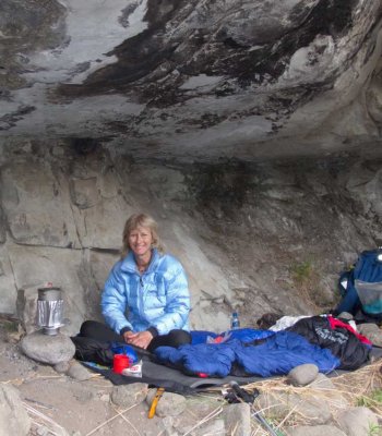
We left our packs at the top of Mlambonja Pass, and went down to the Kwakwatsi River to collect water before returning to our packs and going down to Twins Cave. The next day we were going to descend Xeni Pass South, and along the way we would go around the peak of Mlambonja Buttress, and try to get to a position where we could see if the grass slope we had tried the previous day came out at the summit.
We got to a saddle on the escarpment edge, and there was a grass slope going down, and moving a bit closer to the edge we could see that this was the grass slope David had seen the previous day, and that it did indeed go to the summit. So this is a variation of Mlambonja Buttress North Pass. The photo below shows the grass slope below the escarpment cliffs, coming up to the top of the escarpment at the saddle just to the south of Mlambonja Buttress peak.
The Google Earth image shows our track in blue (I have omitted the portion down to the Kwakwatsi River and Twins Cave), from Mlambonja campsite to the top of Mlambonja Buttress North Pass, the ‘detour’ up the side gully grass slope, and the next morning’s walk from the top of Mlambonja Pass to look at the possible variation route. The line I have drawn in in red shows the variation route to the summit.
We enjoyed exploring this unmarked pass, and although I completed all of the marked passes at Didima years ago, I continue to be drawn to explore the unmarked passes (in all areas) that I have seen on previous hikes, and that seem to be different ways up or down, to or from the summit.
We began our ascent of the upper section of the pass gully after descending the side gully from our lunch spot, and the photo below shows the view up the upper gully section of the pass.
A view back down the pass gully, with the side gully crossing the main gully in the sun, and the saddle at the top of the lower section of the pass visible in the background.
The photo below shows the view up the top section of Mlambonja Buttress North Pass, as we went higher the boulders in the gully got less, and it became more of a grass slope. Looking up, we could see what we had thought was a low cliff across the gully high up, and it was fortunately just a bit of a bend in the gully that was not visible from below, with the gully going on smoothly up.
The top section was a grass slope, and we were glad to be up at the top of Mlambonja Buttress North Pass.
Our summit photo, with a background of mist that had suddenly come in, and just as suddenly later went away.
After a break at the top, we headed towards the top of Mlambonja Pass, and had this view back to the top of Mlambonja Buttress North Pass.
We left our packs at the top of Mlambonja Pass, and went down to the Kwakwatsi River to collect water before returning to our packs and going down to Twins Cave. The next day we were going to descend Xeni Pass South, and along the way we would go around the peak of Mlambonja Buttress, and try to get to a position where we could see if the grass slope we had tried the previous day came out at the summit.
We got to a saddle on the escarpment edge, and there was a grass slope going down, and moving a bit closer to the edge we could see that this was the grass slope David had seen the previous day, and that it did indeed go to the summit. So this is a variation of Mlambonja Buttress North Pass. The photo below shows the grass slope below the escarpment cliffs, coming up to the top of the escarpment at the saddle just to the south of Mlambonja Buttress peak.
The Google Earth image shows our track in blue (I have omitted the portion down to the Kwakwatsi River and Twins Cave), from Mlambonja campsite to the top of Mlambonja Buttress North Pass, the ‘detour’ up the side gully grass slope, and the next morning’s walk from the top of Mlambonja Pass to look at the possible variation route. The line I have drawn in in red shows the variation route to the summit.
We enjoyed exploring this unmarked pass, and although I completed all of the marked passes at Didima years ago, I continue to be drawn to explore the unmarked passes (in all areas) that I have seen on previous hikes, and that seem to be different ways up or down, to or from the summit.
Please login or register to view the images attached to this post.
Last edit: 28 Jul 2024 21:37 by tonymarshall. Reason: Correct formatting
The following user(s) said Thank You: Serious tribe, Stijn, JonWells, DeonS, tiska, ghaznavid, hikingle, Smurfatefrog, Sabine, ASL #Bivak, AndrewP, supertramp, Riaang, TheRealDave, riaan300, Smithers_23
Please Log in or Create an account to join the conversation.
- tonymarshall
-
Topic Author
- Offline
- VE Advisory
-
Less
More
- Posts: 768
- Thank you received: 2233
30 Jul 2024 12:47 #79159
by Sabine
Replied by Sabine on topic Mlambonja South Pass
Thank you Tony for that excellent write up. How much more difficult would you rate this pass compared to Mlambonja?
Please Log in or Create an account to join the conversation.
01 Aug 2024 10:20 #79161
by tonymarshall
Replied by tonymarshall on topic Mlambonja South Pass
The terrain of the two passes is quite similar in the range of the lower gully section of Mlambonja Buttress North Pass, although Mlambonja Pass doesn't have the boulder/scree section at the top. So this steep boulder section, and the major difference of not having a trail, are the factors that make MBN more difficult than Mlambonja Pass, which has a trail the entire way. I would also say that the difficulty is not that much more, but the time required is a lot more, because of MBN not having a trail. Perhaps one point more difficult on the VE scale of difficulty, but the extra time factor is more significant.
The following user(s) said Thank You: Sabine, ASL #Bivak
Please Log in or Create an account to join the conversation.
- tonymarshall
-
Topic Author
- Offline
- VE Advisory
-
Less
More
- Posts: 768
- Thank you received: 2233
08 Aug 2024 20:59 #79167
by AndrewP
Replied by AndrewP on topic Mlambonja South Pass
Well done guys
The variation I took came down the red line on the Google Map, crossed your pass and continued to the normal pass joining the path at about the J
The variation I took came down the red line on the Google Map, crossed your pass and continued to the normal pass joining the path at about the J
The following user(s) said Thank You: tonymarshall
Please Log in or Create an account to join the conversation.
08 Dec 2024 13:53 #79378
by Serious tribe
Replied by Serious tribe on topic Mlambonja South Pass
Hi Andrew
How would you rate that steep gully section that you went down to reach the letter J? (Perhaps we should just call it J-gully) From GMaps it looks quite steep and rocky. I would be climbing it as opposed to coming down it. So the idea would be to either use Tony's MBN up to the nek and then turn left up the side gully to the top of Mlambonja Buttress or to go via the normal route and then ascend J gully and continue to the top.
@Tony. Any possable options to bivy in the gully above the nek area? Water would be an obvious issue.
Please Log in or Create an account to join the conversation.
- Serious tribe
-

- Offline
- Platinum Member
-

Less
More
- Posts: 1056
- Thank you received: 770
08 Dec 2024 15:09 #79379
by AndrewP
Replied by AndrewP on topic Mlambonja South Pass
Hi
If I recall correctly, I was on grass slopes the whole way, just left of the gully itself coming down. Never steep enough to get excited about
If I recall correctly, I was on grass slopes the whole way, just left of the gully itself coming down. Never steep enough to get excited about
The following user(s) said Thank You: Serious tribe
Please Log in or Create an account to join the conversation.
09 Dec 2024 08:29 #79382
by Serious tribe
Replied by Serious tribe on topic Mlambonja South Pass
Thats good to know. Sounds like a cool, but long variation to M pass. But a new or seldom used route is always exciting!
Please Log in or Create an account to join the conversation.
- Serious tribe
-
- Offline
- Platinum Member
-
Less
More
- Posts: 1056
- Thank you received: 770
10 Dec 2024 11:51 #79385
by tonymarshall
Replied by tonymarshall on topic Mlambonja South Pass
The challenge with finding somewhere to bivy is the lack of fairly level ground, and the rocks that are all around in the grass that probably disrupt any fairly level areas. Although Andrew's comment about the route never being too steep is quite correct in a hiking sense, the terrain is generally too steep to bivy comfortably, unless you make a plan to lean against a big rock to avoid sliding down the slope. The best fairly level/flat options I can recall where it might be possible to bivy are at the saddle/nek I refer to, and at the next saddle/nek up on the variation route we went up, where we had lunch, before coming down again.
The following user(s) said Thank You: Serious tribe
Please Log in or Create an account to join the conversation.
- tonymarshall
-
Topic Author
- Offline
- VE Advisory
-
Less
More
- Posts: 768
- Thank you received: 2233
11 Jun 2025 14:07 #79651
by tonymarshall
Replied by tonymarshall on topic Mlambonja South Pass
Please note that after Serious Tribe and I did Mlambonja Buttress North Pass in April, it seemed appropriate to change the name of the pass in this thread to Mlambonja South Pass. The small group who had done both of these passes were consulted about this name change, and all were in agreement. There is also an edit note at the beginning of the first post in this topic to explain the name change.
Riaang and his group did this pass after I did the pass write up, and in his write up of the pass, on a different thread, he also refers to the pass as Mlambonja South Pass.
Riaang and his group did this pass after I did the pass write up, and in his write up of the pass, on a different thread, he also refers to the pass as Mlambonja South Pass.
The following user(s) said Thank You: Serious tribe
Please Log in or Create an account to join the conversation.
- tonymarshall
-
Topic Author
- Offline
- VE Advisory
-
Less
More
- Posts: 768
- Thank you received: 2233
