
- Forum
- Drakensberg Forum
- Drakensberg Hiking
- AmaNgwane (Mnweni & other areas)
- Up Fangs down Mnweni September
Up Fangs down Mnweni September
15 Aug 2021 18:17 #77091
by swartpeet
Up Fangs down Mnweni September was created by swartpeet
Hi all. I am planning on going up Fangs pass and down Mnweni pass on the September long weekend. I am aware that the path has been washed away. Is there anyone with recent tracks of the route that they can share?
I am planning on spending Friday night at the base of Fangs pass(a pin location of the "camping spot" will be nice). Then going up fangs to Ledges Cave for Saturday night and down Mnweni. Any advice will be appreciated. None of the group has been there before.
Does anyone have contact numbers for locals that will be able to give me lift on the dirt road?
Thanks
Please Log in or Create an account to join the conversation.
28 Sep 2021 18:10 #77149
by Lana.1
Replied by Lana.1 on topic Up Fangs down Mnweni September
Hi:). I'm new on this group and just read this post. Did you do this route? I'm planning to do it in October. I've done Mnweni and down Rockeries and am now keen to see Fangs. If you did the hike I would really appreciate a route download if you have one!
Please Log in or Create an account to join the conversation.

28 Sep 2021 18:32 #77150
by Smurfatefrog
Replied by Smurfatefrog on topic Up Fangs down Mnweni September
Welcome Lana
A big difference between Fangs and the other 2 passes is the lack of path and the boulder hopping.
Just make sure you are prepared for that.
I'll send you a track for a Fangs and Rockeries route
A big difference between Fangs and the other 2 passes is the lack of path and the boulder hopping.
Just make sure you are prepared for that.
I'll send you a track for a Fangs and Rockeries route
Please Log in or Create an account to join the conversation.
- Smurfatefrog
-

- Offline
- Moderator
-

Less
More
- Posts: 1129
- Thank you received: 1541
12 Oct 2021 05:42 #77189
by Drakie1
Replied by Drakie1 on topic Up Fangs down Mnweni September
Hi Smurfatefrog. Would it perhaps be better for the not so fit to go up with Rockeries and down Fangs? Are there any camping spots higher up towards Fangs pass than the one where Fangs and Mnweni routes split? I have done Mnweni Rockeries and a couple of other passes, also DGT in 2019. Please be so kind to send me your Fangs Rockeries track. We might be doing it at the end of this year or early January.
Please Log in or Create an account to join the conversation.

12 Oct 2021 07:40 #77190
by Smurfatefrog
Replied by Smurfatefrog on topic Up Fangs down Mnweni September
Hi Drakie, there is a campspot 3km up the Fangs valley, just past the waterfall. It all depends how many days you want to break the hike up over. This is a really scenic spot and is great at sunrise.
I have attached the track here
I have attached the track here
Please login or register to view the file attached to this post.
Please Log in or Create an account to join the conversation.
- Smurfatefrog
-
- Offline
- Moderator
-
Less
More
- Posts: 1129
- Thank you received: 1541
12 Oct 2021 20:12 - 13 Oct 2021 07:42 #77194
by swartpeet
Replied by swartpeet on topic Up Fangs down Mnweni September
Hi guys. I was asked nicely to do a writeup on this trip. Seeing as questions about the hike is being asked, I think now is the right time to do so.
Right. Planning my first "off the beaten track hike". Pray for good weather. We are a group of 6 fairly experienced hikers with the Bell Traverse and Mafadi our major hikes. Our group consists of three guys and three girls. Everyone was eager and I got tracks from a source (Thanks Riaan), a few tips from a South African Adventures Guide (Thanks Rasta) and a shuttle service for the dreaded first 1km gravel road to the Mnweni Valley (Thanks Sipho).
Pray for good weather.
All was set to drive from Jhb to MCC and start hiking to the bottom of Fangs pass on Thursday, go to Fangs cave on Friday, sleep in Ledges Cave on Saturday and hike down Mnweni and drive back on Sunday. With Friday the 24th of September being a public holiday, just one day of leave was required.
Problem : No one can get leave. Solution: Do the hike in three days instead of four.
Pray for good weather.
With this, one of the guys(The one with the 2nd tent) wasn't feeling up to the challenge and bailed.
Problem: No tent. Solution: Buy one. Hansie Slim, took one for the team and purchased a tent. (Hansie Slim is also the only one in our group that lives in CPT and purchased plane tickets for the trip)
Pray for good weather.
Hansie Slim was not so "Slim" and played a game of touch rugby where he sprained his ankle and was out of the trip. He agreed to us borrowing his brand new tent, which I had to carry, with my own, and all the cooking utensils, pots and stove. I complained. A lot.
Problem: One stubborn guy and three girls on a scary hike. Solution: Be stubborn and do it anyway.
Pray for good weather.
With that, we drove from Jhb early Friday morning, had a quick breakfast at Harrismith Wimpy and met our Shuttle at MCC at around 9:30. After signing the Mountain Register, we got on the bright blue Hilux and after a 10minute drive, saving us an hours walk, we were of into the beautifully green Mnweni Valley. The foot path is so clear that my Garmin was not switched on until we passed Mlambus Kraal. Not having been in the Valley before, we lost the tracks for a few minute, but the trusty Garmin got us back on track in a jiffy. At exactly 13:00 one of the girls decided that it must be lunch time now. We sat down beneath one of the Protea bushes and had fantastic chicken wraps.
Just as we finished us we heard gun shots. Automatic rifle was my first thoughts. We were quite. Everything was quite. I didn't know what to do. The shots came from the hill behind us and sounded very close. I didn't want to run, as whoever hasn't seen us yet, but I didn't want to stay either. I stood up slowly and almost crawled out beneath the bush to see if I can maybe see someone. I prayed. Just as I opened my eyes I saw a man coming down the hill towards us. He hasn't seen me, so I decided to go in the opposite direction, back to Mlambus Kraal until we found another hiking group. Safety in numbers I thought. Just as we turned to walk away, he came into picture and has now definitely seen us. I didn't see a gun and felt comfortable to approach him. When asking him if he heard the gun shots, he immediately started to apologize. "Sorry, sorry, I didn't know we had guests. Sorry, Sorry." I now saw his pistol in his holster and realized that the shots must have been into a rock, thus the double "automatic rifle sound". His name is Sfiso, he knows Mr Leonard at MCC and he is a shepherd who lives in Five Star Cave. I asked the girls if they felt comfortable enough with his explanation to continue, and with all in agreement we set on our way.
As soon as we crossed the river we got lost. Tracks doesn't help hear at all. You are on track, then off track. After bundu bashing our way through a few bushes we were on a clear track again and heading into the fangs valley, passing Sfiso in Fave Star Cave and heading to our campsite. We reached the waterfall at around 16:00 and set up camp close by in the most glorious wind still weather I've ever experienced in the berg. (I don't know how to add pictures here, so please see my attachements)
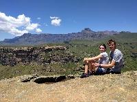
The night was good and we were up at 05:00. Big day ahead. Coffee, Breakfast, breaking up camp and we were away at 06:30. I was not aware that the tracks would be so useless. There was literally no foot path and trying to stay "on track" was a nightmare. At first we were in the river bed, then out and against the steep sides with unbelieve exposure. Later we decided to screw the tracks and just head up the pass. You cant really get lost. I just checked the watch every now and again and it was smooth sailing. Not really, the pass is tough. Steep. Very steep. Non the less, we were making good ground and at around 11:00 we could see the top of the pass. Keeping an eye on my watch, I wanted to pass Fangs Cave and we turned left into a gulley. The 2nd one, not the 1st. Mistake. Dead end. There was no way I was going down, so I dropped my bag and climbed up to search for another route. Being successful, I returned to the girls and we head up. We reached the top of the pass at around 12:00. Views were spectacular.
We followed the tracks to the river. Filled up with water and navigated to Ledges Cave. We hiked at a steep pace, me complaining about the second tent and the girls about me not wanting to rest. We ate lunch at 13:00 on top of Rwanqa pass. Hotdogs with McDonalds Ketchup. From there caught and passed two hiking groups and met a few Basotho herders with their dogs. We reached the top of Mnweni Pass at around 16:30 to find the majestic view of around 20 tents pitched. We decided not to go to Ledges Cave and spend the night on the flat open area under the starts with fellow hikers surrounding us. Safety in numbers.
Dinner. Checkers Meaty Beef and Barley soup. Coffee. Pudding. Sleep
After a good, but cold night's sleep, we were up at 05:00. Coffee, breakfast, break up camp and we were on our way at 06:00. Mnweni Pass is a highway. A spectacularly beautiful highway. We took it slow, taking in the views. Taking pictures and eating snacks. With a clear path and nice big boulders to walk on, we passed Chi-Chi Bush camp at around 09:30. We got lost again crossing the river but not for too long. River crossings are a bitch. On Friday I arranged with Sipho to be at Mnweni Valley where he dropped us off at 14:00. We soon realized that we will be an hour early. With no signal we couldn't reach him and just hoped and prayed that he will be there. Going through the farm gate, my wife shouted "Kyk die blou bakkie!" What are the odds of two bright blue pickups in the Mnweni area. We tried to get his attention, but he was too far to hear. Eventually I shouted and heard his horn as a return call. He saw us! We were down at 13:10 and our knight in shining armor was a young guy with a bright blue 1970 Hilux.
We reached MCC, took a quick shower and drove back. McDonalds for lunch. We were home by 20:20. Exhausted. Ready for work the following morning.....
Right. Planning my first "off the beaten track hike". Pray for good weather. We are a group of 6 fairly experienced hikers with the Bell Traverse and Mafadi our major hikes. Our group consists of three guys and three girls. Everyone was eager and I got tracks from a source (Thanks Riaan), a few tips from a South African Adventures Guide (Thanks Rasta) and a shuttle service for the dreaded first 1km gravel road to the Mnweni Valley (Thanks Sipho).
Pray for good weather.
All was set to drive from Jhb to MCC and start hiking to the bottom of Fangs pass on Thursday, go to Fangs cave on Friday, sleep in Ledges Cave on Saturday and hike down Mnweni and drive back on Sunday. With Friday the 24th of September being a public holiday, just one day of leave was required.
Problem : No one can get leave. Solution: Do the hike in three days instead of four.
Pray for good weather.
With this, one of the guys(The one with the 2nd tent) wasn't feeling up to the challenge and bailed.
Problem: No tent. Solution: Buy one. Hansie Slim, took one for the team and purchased a tent. (Hansie Slim is also the only one in our group that lives in CPT and purchased plane tickets for the trip)
Pray for good weather.
Hansie Slim was not so "Slim" and played a game of touch rugby where he sprained his ankle and was out of the trip. He agreed to us borrowing his brand new tent, which I had to carry, with my own, and all the cooking utensils, pots and stove. I complained. A lot.
Problem: One stubborn guy and three girls on a scary hike. Solution: Be stubborn and do it anyway.
Pray for good weather.
With that, we drove from Jhb early Friday morning, had a quick breakfast at Harrismith Wimpy and met our Shuttle at MCC at around 9:30. After signing the Mountain Register, we got on the bright blue Hilux and after a 10minute drive, saving us an hours walk, we were of into the beautifully green Mnweni Valley. The foot path is so clear that my Garmin was not switched on until we passed Mlambus Kraal. Not having been in the Valley before, we lost the tracks for a few minute, but the trusty Garmin got us back on track in a jiffy. At exactly 13:00 one of the girls decided that it must be lunch time now. We sat down beneath one of the Protea bushes and had fantastic chicken wraps.
Just as we finished us we heard gun shots. Automatic rifle was my first thoughts. We were quite. Everything was quite. I didn't know what to do. The shots came from the hill behind us and sounded very close. I didn't want to run, as whoever hasn't seen us yet, but I didn't want to stay either. I stood up slowly and almost crawled out beneath the bush to see if I can maybe see someone. I prayed. Just as I opened my eyes I saw a man coming down the hill towards us. He hasn't seen me, so I decided to go in the opposite direction, back to Mlambus Kraal until we found another hiking group. Safety in numbers I thought. Just as we turned to walk away, he came into picture and has now definitely seen us. I didn't see a gun and felt comfortable to approach him. When asking him if he heard the gun shots, he immediately started to apologize. "Sorry, sorry, I didn't know we had guests. Sorry, Sorry." I now saw his pistol in his holster and realized that the shots must have been into a rock, thus the double "automatic rifle sound". His name is Sfiso, he knows Mr Leonard at MCC and he is a shepherd who lives in Five Star Cave. I asked the girls if they felt comfortable enough with his explanation to continue, and with all in agreement we set on our way.
As soon as we crossed the river we got lost. Tracks doesn't help hear at all. You are on track, then off track. After bundu bashing our way through a few bushes we were on a clear track again and heading into the fangs valley, passing Sfiso in Fave Star Cave and heading to our campsite. We reached the waterfall at around 16:00 and set up camp close by in the most glorious wind still weather I've ever experienced in the berg. (I don't know how to add pictures here, so please see my attachements)
The night was good and we were up at 05:00. Big day ahead. Coffee, Breakfast, breaking up camp and we were away at 06:30. I was not aware that the tracks would be so useless. There was literally no foot path and trying to stay "on track" was a nightmare. At first we were in the river bed, then out and against the steep sides with unbelieve exposure. Later we decided to screw the tracks and just head up the pass. You cant really get lost. I just checked the watch every now and again and it was smooth sailing. Not really, the pass is tough. Steep. Very steep. Non the less, we were making good ground and at around 11:00 we could see the top of the pass. Keeping an eye on my watch, I wanted to pass Fangs Cave and we turned left into a gulley. The 2nd one, not the 1st. Mistake. Dead end. There was no way I was going down, so I dropped my bag and climbed up to search for another route. Being successful, I returned to the girls and we head up. We reached the top of the pass at around 12:00. Views were spectacular.
We followed the tracks to the river. Filled up with water and navigated to Ledges Cave. We hiked at a steep pace, me complaining about the second tent and the girls about me not wanting to rest. We ate lunch at 13:00 on top of Rwanqa pass. Hotdogs with McDonalds Ketchup. From there caught and passed two hiking groups and met a few Basotho herders with their dogs. We reached the top of Mnweni Pass at around 16:30 to find the majestic view of around 20 tents pitched. We decided not to go to Ledges Cave and spend the night on the flat open area under the starts with fellow hikers surrounding us. Safety in numbers.
Dinner. Checkers Meaty Beef and Barley soup. Coffee. Pudding. Sleep
After a good, but cold night's sleep, we were up at 05:00. Coffee, breakfast, break up camp and we were on our way at 06:00. Mnweni Pass is a highway. A spectacularly beautiful highway. We took it slow, taking in the views. Taking pictures and eating snacks. With a clear path and nice big boulders to walk on, we passed Chi-Chi Bush camp at around 09:30. We got lost again crossing the river but not for too long. River crossings are a bitch. On Friday I arranged with Sipho to be at Mnweni Valley where he dropped us off at 14:00. We soon realized that we will be an hour early. With no signal we couldn't reach him and just hoped and prayed that he will be there. Going through the farm gate, my wife shouted "Kyk die blou bakkie!" What are the odds of two bright blue pickups in the Mnweni area. We tried to get his attention, but he was too far to hear. Eventually I shouted and heard his horn as a return call. He saw us! We were down at 13:10 and our knight in shining armor was a young guy with a bright blue 1970 Hilux.
We reached MCC, took a quick shower and drove back. McDonalds for lunch. We were home by 20:20. Exhausted. Ready for work the following morning.....
Please login or register to view the images attached to this post.
Last edit: 13 Oct 2021 07:42 by JonWells. Reason: Inserted image
The following user(s) said Thank You: Serious tribe, elinda, JonWells, hikingle, Smurfatefrog, tonymarshall, TheRealDave, riaan300, wildingo, Rossp
Please Log in or Create an account to join the conversation.
13 Oct 2021 10:52 - 13 Oct 2021 11:12 #77204
by tonymarshall
Replied by tonymarshall on topic Up Fangs down Mnweni September
Thanks for an informative write up, and good that you all had a pleasant hike after all the initial problems with logistics, and the horror experience of the gunshots.
There are three possible reasons for the difficulties you experienced with the gps track in the approach to Fangs Pass; the source of your track may have taken some odd turns or routes or recorded navigation mistakes in their track without you knowing about it, which made the track illogical for you to follow; the gps signal may have been low in that area, causing the track you were trying to follow, and your own track, to be slightly unaccurate and not match each other; or you need to get more experience in using gps tracks for navigation in difficult terrain, which you have already started to get on this hike and will certainly pick up over time. Another reason not related to the gps track, could be the change to the riverbed after the floods in January, but you were aware of that, and were able to expect it - if this is the reason you say that the gps track was useless (at that moment, in that section) then we are on the same page.
As someone who makes exclusive use of gps (and my own knowledge) for navigation in the berg, I don't like your comment on the gps track being useless for navigation. I am not being critical, but I just don't want your comment to put other people off using gps navigation in the berg. I have used tracks from other people (who I trust) to navigate successfully many times, combined with my own knowledge and experience of following gps tracks, knowing when to expect problems with gps signal, and a good sense of where the route should be going. You say that the gps track got you back on track after Mlambu's kraal so it was clearly very useful to you then, and not useless. Gps navigation is very useful and powerful, provided of course that the person doing it knows what they are doing.
Last edit: 13 Oct 2021 11:12 by tonymarshall. Reason: spelling
Please Log in or Create an account to join the conversation.
- tonymarshall
-

- Offline
- VE Advisory
-
Less
More
- Posts: 768
- Thank you received: 2233
13 Oct 2021 12:29 #77206
by Smurfatefrog
Replied by Smurfatefrog on topic Up Fangs down Mnweni September
I think sometimes people try follow tracks too closely.
In areas like Fangs where there is no path, its much easier to check the general direction and to make your own way up the boulders or a big grass slope, rather than trying to move 10m to the right for example
In areas like Fangs where there is no path, its much easier to check the general direction and to make your own way up the boulders or a big grass slope, rather than trying to move 10m to the right for example
Please Log in or Create an account to join the conversation.
- Smurfatefrog
-
- Offline
- Moderator
-
Less
More
- Posts: 1129
- Thank you received: 1541
13 Oct 2021 13:21 #77207
by ASL #Bivak
Replied by ASL #Bivak on topic Up Fangs down Mnweni September
true story, as we've seen 'many' times you need to look at the physical layout of an area carefully due to potential small variations in the tracks. Even a few metres variance can be on or off the path so it's a practical combination of GPS track and physicall assessment on your part...
Please Log in or Create an account to join the conversation.
- ASL #Bivak
-

- Offline
- Platinum Member
-

Less
More
- Posts: 598
- Thank you received: 216
13 Oct 2021 17:06 #77208
by swartpeet
Replied by swartpeet on topic Up Fangs down Mnweni September
Alright, before we get carried away here. I will never attempt a hike without my GPS and a track. Tracks are awesome. They were just useless in the washed away river bed and in Fangs pass as I was expecting a physically visible foot path.
Sincerest apologies.
Sincerest apologies.
The following user(s) said Thank You: tonymarshall
Please Log in or Create an account to join the conversation.
