Gone West
14 Feb 2016 19:27 #67030
by AndrewP
At the beginning of this year, I saw a post from Kyle asking if anyone wanted to run a GT with him. This is a big ask, especially considering I had by then just decided no speed GT’s for me for a while to come. I did however contact him and suggest we at least do a run together.
Kyle is working as a teacher in a tiny town, about 30km from Afriski. We thus agreed to meet there. Kyle suggested a loop about 80km long, which I thought a bit ambitious for a first run together so I suggested something shorter as an alternative. In the end, we never actually discussed it – his loop looked so much fun we were always going to do it.
I have never been to Afriski before, so left Joburg early enough on Friday to get there while it was still light so I could orientate myself. While I was driving, Kyle ran to Afriski and I started wondering if I was batting out of my league.
We met up easily enough and had dinner together, during which we got to know each other, sorted out the basics of the route and a few other logistics.
Kyle has a home made backpack made out of the fabric used for mealie meal bags. It deserves a special post on the "homemade gear" thread.
We woke up at 4am, and were moving by just after 4:30. We headed u p the ski slope and got onto a ridge leading to the nearby peak Pitsong. Just short of the summit, Kyle announced that he had not yet bagged the peak and suggested we go for it. Winner attitude, we went for it! Pitsong is about 3295m high and thus falls into the incredible list of “just another random 3000m high peak in Lesotho”. We had a great sunrise as we headed down a long ridge leading west.
The ridge had a few small rock bands but all were easy to negotiate and before too long, we had reached the main river valley at under 2500m. We had an enormous slog ahead of us, so decided to take a valley up so that we would have access to water. Each of us sneaked in a swim on one of many delightful pools along the way.
We finally hit the main objective. In this region, the western escarpment of the Maluti’s is a high ridge line. With ground dropping off 500m on either side, it brought back memories of the Skyrun. Here, our pace slowed somewhat as each of us was taken away by the view. We kept taking photos, stopped to look at the view and any other excuse we could think of.
We literally ran off the edge of my map and I badly underestimated the distance to still go. We summited about a dozen peaks along the way, each with about 100m prominence and offering a spectacular view. After several hours, we looked down into a valley to see Maliba Lodge. A bit further along, Kyle (finally) recognised where we were and we took a sharp left onto a good trail heading down another ridge, the Nolomo Pass.
By now, Kyle had run out of water, and even after using 1l of my water was still struggling. We found a few rain-filled pools from the night before. I drank happily, and he drank a bit, and then, being nervous of the water swallowed a water purification tablet on his empty stomach. Bad news !
The ridge leading downwards was amazing, it offered one of those aesthetic lines we all dream of. Kyle though, was suffering badly from the purification tablet and 2 hours later finally brought it all up and suddenly seemed happier again.
We made it to the river crossing after sunset. I went for a swim anyway, and Kyle ground his way up a steep slope to gain the road. We made it into his village after dark, but refused to pull out our headlamps. I had at least seen the village from a distance away, and it reminded me of the villages I saw when I “cycled” down the Senqu.
About here, my GPS stats suggested we had done ¼ of a GT. Kyle was not happy to hear that.
We had a pleasant evening at his place. It is a simple, 1 room, round rondawel, with a basic solar panel setup. The nearest proper town is about an 8hr drive away, so fresh anything is not part of the equation. We had some filling lentil burgers for supper and passed out.
On Sunday morning, we woke up at 4:10, and within 5 minutes were out the door, heading up the valley. Somewhere after 4:30, the only taxi of the day will drive up the valley, and we hoped to catch it. We passed the place where the taxi driver sleeps, while he was still in dreamland, but carried on walking up the valley partially to keep warm and mainly just because that is better than waiting.
The taxi did eventually catch up to us, and I saved about 2km of walking up the road. I am glad it was only a few minutes because the volume of the music was LOUD. At the end of the road, Kyle headed back down in the taxi, after pointing out to me where I was to go.
I followed the road a bit further, eventually entering a diamond mine. I ignore the sign at the gate and made a point of not looking around in a suspicious way. I soon had to turn off the road and started making my way up a 600m high hill.
I passed a few kraals, and noticed something interesting. The dogs bark and show an interest in you, but that killer mode is absent.
I finally reached the ridge proper and followed a lovely path back up towards Pitsong. From here, a few short minutes of flat and downhill got me back to Afriski in time for a great breakfast.
In all, one of the most spectacular routes I have done! The complete loop is about 80km with 4000m altitude gain/loss.
Please Log in or Create an account to join the conversation.
14 Feb 2016 19:34 #67031
by AndrewP
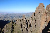
Shortly after Pitsong, heading a long way down. The ridge in distance is the objective
Plenty of water down there")
Got to go for a swim
Looking down the escarpment. Buthe Buthe is somewhere in the haze.
Kyle enjoying the view
After a while, the bumps on the ridge get a bit much.
The only photo I actually got that shows the drop off on both sides
Shortly after Pitsong, heading a long way down. The ridge in distance is the objective
Plenty of water down there
Got to go for a swim
Looking down the escarpment. Buthe Buthe is somewhere in the haze.
Kyle enjoying the view
After a while, the bumps on the ridge get a bit much.
The only photo I actually got that shows the drop off on both sides
Please login or register to view the images attached to this post.
Please Log in or Create an account to join the conversation.
14 Feb 2016 19:43 #67032
by AndrewP
On the right hand side of the picture, is the ridge we followed all the way down
Approaching the top of Nelomo Pass
Somewhere, back there is Afriski
We followed the ridge down into the horseshoe bend of the river, crossed the saddle and spent a night in the village just beyond
On the right hand side of the picture, is the ridge we followed all the way down
Approaching the top of Nelomo Pass
Somewhere, back there is Afriski
We followed the ridge down into the horseshoe bend of the river, crossed the saddle and spent a night in the village just beyond
Please login or register to view the images attached to this post.
Please Log in or Create an account to join the conversation.
14 Feb 2016 21:44 #67034
by ghaznavid
Thanks for sharing, Andrew 
I wonder if anyone has ever done a Middle Ridge escarpment traverse - there are 3200+m peaks right near Matebeng Pass, so it should be at least equally epic to a KZN Escarpment GT.
Now I wonder what the rules for the speed record on the Middle Ridge GT route are
I wonder if anyone has ever done a Middle Ridge escarpment traverse - there are 3200+m peaks right near Matebeng Pass, so it should be at least equally epic to a KZN Escarpment GT.
Now I wonder what the rules for the speed record on the Middle Ridge GT route are
Please Log in or Create an account to join the conversation.