This pass is one of the more difficult passes in the Cathedral Peak area but is still used quite often. This is probably due to the fact that it is the most direct route to the escarpment from the hotel, has a large and comfortable cave at it s top (Twins cave) and is often used as the third day of a popular weekend route between Mlambonja Pass and Organ Pipes Pass.


Rating:
* * * (6/10)
Difficulty of the pass is rated from 1-10 (10 being very difficult, only to be attempted by the fit and experienced). A subjective quality rating is indicated by the number of stars (1 being low, 5 being the highest). Factors such as scenic beauty and overall experience come into play here, which may differ from person to person.

Access:
The base of Mlambonja Pass can be reached from the Cathedral Peak Hotel by heading up the Mlambonja valley and climbing up the ridge which gets you to the contour path. Mlambonja Pass starts 2 km right (west) along the contour path when the path rejoins the Mlambonja River.

Details:
The distance from the contour path at the base of Mlambonja Pass to its summit is 3 km with an altitude gain of 1000m.

Route:
Where the contour path crosses the Mlambonja River, there are some cairns marking the path up the Mlambonja Pass along the river itself. The path is very vague and overgrown at first but as long as you keep climbing up along the river, you are on the right route. About 500m (in distance) up the river, the path heads up a small ridge on the left (south) side of the river. Reaching the top of the ridge, it contours to the right and descends quite steeply back to the main river just above a waterfall. From this point onwards, the path follows the river until the steep grassy slopes near the top of the pass are reached. It then follows an easier line of wide zigzags all the way to the top of the pass at 3000m.

Finding the pass from the escarpment:
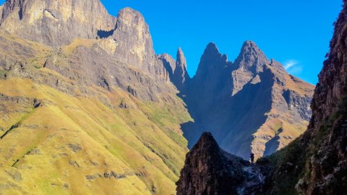
The top of Mlambonja Pass is well-marked by 3 cairns and is situated at a high point on the edge of the escarpment, just south of where the Cathedral Range joins the escarpment.

Overnight Spots:
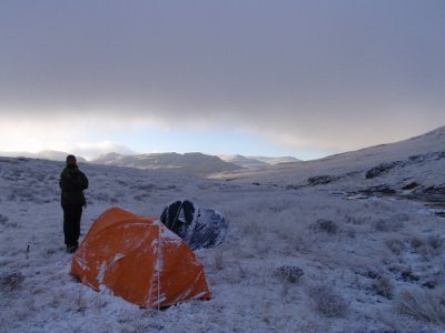
There is no good camping near the base of the pass except on a contour path ridge about 1 km before the pass itself. This campsite is, however, very exposed to wind and lightning. Twins cave is very roomy cave with good shelter and is situated about 100m in altitude below the top of Mlambonja Pass. To reach it, turn right off the main path to cross over the saddle between the Twins and the escarpment. A faint path then descends down the other end of the saddle and Twins cave can be found about 50m to the right (east) of this saddle. There are many good camping spots on the escarpment itself.

Water:
In Summer, there is water in the river all the way up the pass until the grassy slopes are reached just past the halfway mark. The next water can be found in the Kwakwatsi River on the escarpment, about 500m from the top of Mlambonja Pass.


Forum Topic:

More info can be found on the forum at:

http://www.vertical-endeavour.com/forum/11-drakensberg-passes/55697-mlambonja-pass.html

Log in to comment


Serious tribe's Avatar
Serious tribe replied to: #79871 21 Aug 2025 11:17
Always....

This image is hidden for guests.

Riaang's Avatar
Riaang replied to: #79870 21 Aug 2025 09:25
ST,

I would definitely not try the upper route option as my first choice. It will be on a side slope and over very uneven terrain.
Lower down is relatively flat, there is a path, yes the path is steep in the one section but not any more than steep loose gravel paths you find all over the berg.

We're talking of a distance of about 250m here, I think you are possibly overthinking this section a bit. Just stick to the lower down section near the river, trust me, it's going to be easier and faster :-)
Serious tribe's Avatar
Serious tribe replied to: #79869 20 Aug 2025 10:47
Hi Riaang.  I took your first two images and merged them in photoshop to give me this view.  Plus the google view plus the elevation plot.  To my mind, I am always happy to follow the path, it is easier, dont have to think and generally because of this you go faster.  However in this case, if my idea is not go to the tree camp, but push past that, I dont want to drop all that altitude and then have to route find and negotiate the river rocks and course with a full pack.  I certainly dont mind forging a new path. So my idea is to cut off from the main path and countour above that little streamline and then drop down to the larger streamline.  The elevation put doesnt show a huge variance.  Just not too sure waht the camber of that contour of the slide slope will have.   


Serious tribe's Avatar
Serious tribe replied to: #79868 20 Aug 2025 09:51
Those are useful.   We just a need a herd of elephants now to trample down that section, or a large party of hikers

This image is hidden for guests.

Riaang's Avatar
Riaang replied to: #79867 19 Aug 2025 15:46
In the 3rd picture, where the side gully meets the main riverbed, right at the junction of the 3 legs of the "Y" is the spot where we normally stop for either going up or down the pass. The picture after this shows the large tree where you can camp right at the left of the image.
Riaang's Avatar
Riaang replied to: #79866 19 Aug 2025 15:42
With dropping down into the Mlambonja riverbed via the 1TreeHill path, I took the opportunity to snap a couple of pics of the section under discussion recently. Maybe this view will help you "see" the path/terrain better. It's a closer-up image than what you'd get on Google Earth. But, in all honesty, it's not difficult to find your way through the undergrowth here. Much easier than say going up Ships.


tiska's Avatar
tiska replied to: #79837 25 Jul 2025 13:37

I have just added an October 2019 burnt view of the area.  I dont see a distinctive path on the blue route that you are using Riaang which i would have thought given that all the foliage is burnt.  But that does give me some hope that if you used it, it is theoretically there.  And of course, it does depend on the season.  

I have added in blue routes for ther small drainage line which might be what Tiska is referring to.  Certainly not as bad as ships, but bushwhacking is not my favourite past time, especailly after it has rained

This image is hidden for guests.


Also of interest, is the orange section that has been carved away since all that flooding we had in 2022 and 23.


Hi again ST -
The drainage line I was referring to is the pale blue line in the first of your satellite photos (not the darker blue in the second of the two satellite photos you uploaded). 
The path I followed going down valley was in a shallow drainage line, like a ditch, about half a meter to a meter below the surrounds. As I said, it looked like a path. And looked also like a drainage line. But it became more and more overgrown the closer the ditch got to the ascent out of the river. I just couldn't get through. I started following that path because it coincided with a cairn on the true right hand bank of the river. The cairn was separate from the set of cairns that was marking the way-to-go down the river. The cairn on the true right hand bank had the hallmarks of a 'this is where you can exit the river' sign.

All in all this section of the trail is a mess. In another thread (probably the one about the campsite near the tree) I suggested that it would be a good deed if someone cleaned up the path along a stable bank section - maybe even the drainage ditch. It would only take a pair of small hand-held cutters to get rid of the woody growth. I don't expect the staff ever make it this far away from the work place and those that I have seen would need a chopper ride out if they did ever manage to get to that extreme altitude.

 
Riaang's Avatar
Riaang replied to: #79836 25 Jul 2025 10:16
ST, the path has always been very faint. I've often missed it at the starting point, while looking for it, so there is no way you will see it on Google Earth. Here's how I usually find the path, after I figured it out.

We normally have our first stop coming down Mlambonja pass at that spot where the path to One Tree Hill exits to the left (true left), as you are descending the pass. There is a section of relatively smooth flat rock with the stream 2 to 3m from the top of the rock plate. There used to be a grassy spot right above the rock, but alas, it got destroyed 2 years or so ago after some flooding. Still, normally the upper section of the rock plate is dry and we park off here for a quick bite to eat and drink.

Once done we saddle up and head straight down the rock, hop over the small stream and climb over the pile of rocks about 2.5m high immediately behind the stream. The path starts at the top of the rock pile and it immediately veers off slightly to the left. It took me a few hikes to figure this out. I used to go right, which always ended up in bushwacking. People naturally tend to walk to the right so there appears to be what is a faint path, and there is, but it leads to the bushwacking section. Keep left, closer to the river but not in it and you should be fine. It's worked for us and after having tried various different routes it is my current go to route. Will try to remember to take some pictures for you next time I'm there.
Serious tribe's Avatar
Serious tribe replied to: #79830 23 Jul 2025 15:15
I have just added an October 2019 burnt view of the area.  I dont see a distinctive path on the blue route that you are using Riaang which i would have thought given that all the foliage is burnt.  But that does give me some hope that if you used it, it is theoretically there.  And of course, it does depend on the season.  

I have added in blue routes for ther small drainage line which might be what Tiska is referring to.  Certainly not as bad as ships, but bushwhacking is not my favourite past time, especailly after it has rained

This image is hidden for guests.


Also of interest, is the orange section that has been carved away since all that flooding we had in 2022 and 23.

 
Riaang's Avatar
Riaang replied to: #79829 23 Jul 2025 13:02
The blue route is the one we normally follow. Depending on season and foot traffic, there is either a path or not (typically in the rainy season the path is overgrown). I've never found it to be difficult terrain, but it is a bit up and down and left and right around and over all the obstacles. I basically just stay on the side of the riverbed and head down for the large tree at the campsite. The amount of bushwacking is nothing compared to say for instance what you would find in the Ships Prow riverbed. Once you've done that one, you have a completely new perspective on bushwacking :-)
Serious tribe's Avatar
Serious tribe replied to: #79823 23 Jul 2025 08:03
Hi Tiska
Thanks for you response.  Tony M and I went up and down toward the end of April for our MlamButtNorth trip, and used the pink route on both occasions.  I cant recall which of the pink descents we used, though it did feel steep, but nothing out of the ordinary.  If I had space and time for a machete I would hack out a decent path along the yellow blue route for those who just want continue past the camp.  It is indeed a tricky little section

This image is hidden for guests.

tiska's Avatar
tiska replied to: #79821 22 Jul 2025 16:57
Hi Serious Tribe -
I've walked Mlambonja Pass twice in Aug 2024 (one up, one down) and once in Feb 2025 (down). 
My conclusion, having fussed over the route in this section, is that you are better off on the Pink route - though see below because there is more than one Pink option.

I know you are asking about the blue route but to get to blue you need a bit of yellow and I tried the yellow route twice (both on the way down). It follows a shallow river course and seems, in places, like it was or is or would like to be the path. I gave up on it both times after about 50 m because it was so overgrown. The river was far better. I would have persisted on yellow if it were do-able.

On the Pink descent to the tree, there is more than one path. One branch descends extremely steeply down a horribly eroded gully. This option is slightly higher up valley. The better option breaks off slightly lower down the valley. This descent to the tree on this branch is civilised. The split between the two is not particularly clear. We hit the nasty descent the first time and avoided it by accident the second and third times.


Serious tribe's Avatar
Serious tribe replied to: #79819 22 Jul 2025 15:45
Hi All
Just a quick question about the path from the C5 side that drops into the valley to the tree campsite.  Looking at the GE screen grab, I was wondering if the path splits and continues 'straight' as well as down to the campsite? The pink route is the one that drops down to the campsite, the yellow seems like path, but not the one I am interested in doing.  Is there a possable blue route which I am interested in as I don't wish to drop into the river and camp, I want to by-pass having to do the river and boulder hopping section.  Any thoughts? 
Riaang's Avatar
Riaang replied to: #74872 05 Apr 2019 13:54
Hi GriffBaker,

I've seen a number of flat spots around the Kakwatzi river you can use. Don't have co-ordinates for you, but I can describe the best of the bunch for you. When you come over the col from Twins cave and you start ascending via the footpath, don't go left to where the top of the pass is situated (with the kerns) but rather go straight up that short, steep, grassy section. Go down straight to the river (although this isn't quite possible due to the rocky outcrop in your way, so you will go slightly to the right to go around it, then curve in to the left again.). There is a spot down at the river (at the bend in the river) where (last time I was there) a bunch of rocks were packed where people made fire next to the river. This area could easily accommodate 5 tents. In this vicinity are a number of other flat spots to pitch tents.

Enjoy!
Smurfatefrog's Avatar
Smurfatefrog replied to: #74870 04 Apr 2019 18:07
There are plenty up there, but a spot used fairly commonly is -28.956890° 29.109485°
GriffBaker's Avatar
GriffBaker replied to: #74869 04 Apr 2019 15:51
Hi Guys

Does anybody have a gps waypoint for a good flat camping/tenting area on the escarpment behind Mlambonja that can accommodate about 5 tents?

If I recall there is a good spot near the head of the Kwakwatsi but don't want to wander too far from the top of Mlambonja because we will be descending the following day.

Any info would be appreciated.
WarrenM's Avatar
WarrenM replied to: #73875 27 Aug 2018 11:33

swordfish wrote: Question for those been up and down the pass recently - how badly burned up is the area around the path from the hotel?


I can only comment to a certain degree, yesterday I ran to the zig zags by Neptune pools and while there has been so small section burnt very close the the hotel the balance of that 5k stretch is not burnt at all, and for the better part that I can remember from the day before I don't recall the upper section above those zigzags not been burnt, however the north side of one tree hill ridge has been burnt extensively just about all the way from there up to Cathedral peak, and the areas around Cathedral peak is fairly burnt as well

From the sight of Mlambonja pass that I did get the top of the pass is burnt only as far down as about the saddle that heads over to twins cave, I don't think the rest of the pass is burnt, as the south side of one tree hill and heading towards the pass looked un-burnt.
swordfish's Avatar
swordfish replied to: #73857 22 Aug 2018 15:42
Question for those been up and down the pass recently - how badly burned up is the area around the path from the hotel?
Smurfatefrog's Avatar
Smurfatefrog replied to: #72486 11 Dec 2017 21:27

brettross32 wrote: Hi guys. Is the camp site therefore close to the river bed at C4?

Yup, campsite is 10 to 15m away from the river, on the south bank
brettross32's Avatar
brettross32 replied to: #72485 11 Dec 2017 20:47
Hi guys. Is the camp site therefore close to the river bed at C4?
AdrianT's Avatar
AdrianT replied to: #72242 09 Oct 2017 09:03
Interesting. If I recall we hiked a short bit on the river before heading up onto the path. Pretty similar but no real zig zag. Academic anyway :)

HannesT's Avatar
HannesT replied to: #72221 04 Oct 2017 21:47
Shortly after you start going up the river, after leaving the contour path from One tree hill's side, the path makes a zig-zag up the side of the river. If you follow this you will find a clear path on top. It seemed to go in the wrong direction so we left it and ended up rock hopping for quite some time before finding the path again. Coming back down it is much easier to follow the correct path. The attached photo is my attempt to indicate this zig-zag on my GPS track plot.

firephish's Avatar
firephish replied to: #68148 03 May 2016 11:51
thanks guys, PM sent. :thumbsup:
Stijn's Avatar
Stijn replied to: #68145 03 May 2016 10:51
Here you go: www.movescount.com/moves/move101694019 - note that we lost the path for about 200m at the 2.8km mark of that track - take care in that section as there are a few false paths heading into the bush. It should be fine coming up.

You should be able to download the GPS track from there. Otherwise, drop me a PM and I can send a GPX file.
supertramp's Avatar
supertramp replied to: #68142 03 May 2016 09:44
Hi Firefish,

I've got a reliable track for Mlambonja pass. Send me a PM with your details and I'll send it to you.

Cheers