
Thabana Ntlenyana from Sani Top
Take nothing but litter, leave nothing but a cleaner Drakensberg.
Please Log in or Create an account to join the conversation.

Please Log in or Create an account to join the conversation.
- Outwardbound
-

- Offline
- New Member
-

- Posts: 1
- Thank you received: 0
Kind of, but not really. Definitely not the entire way there anyway.Outwardbound wrote: How well defined is the path looking at Cobhams drakensburg map 5 it gives out in places and Crosses rivers is the best route?
The standard route is to get Sani to drop you off by the bridge. There is a trail for quite a while, I seem to recall it dying near the top of the Sehonghong Ridge. From there I don't recall any trails. Doesn't mean there are none - I have only done TN twice, and one occurrence included crossing the Sani road at sunset and hitting TN's summit at sunrise. I can't say 3AM starts and 9:30PM finishes encourage clear memories of a route!
But I wouldn't take that route from Sani top, there is a much more scenic line one could take. From Sani, walk straight north, aiming for the lowest point in the ridge. Slog up this ridge and drop down the other side, before slogging up the next ridge (towards KaNtuba Pass). Once you are up the second ridge, you follow the escarpment edge around to Mohlesi and follow the Mohlesi ridge to Thaba Ntlenyana. It can't be much further, your vertical is much the same, if not easier, and you get a much more rewarding line. There are no trails that way, but I do have a GPS track.
Please Log in or Create an account to join the conversation.

I hiked to Thabana Ntlenyana (TN) from Sani Top on 2014-09-07 and starting on the common Westerly route round the ridge adjacent to the road into Lesotho (with a finish going back East then West though). When I did a GT with ghaznavid and AndrewP in 2014-2015 I was able to see that a line close to the escarpment between TN and Sani Top had some major advantages viz.:
1. It avoids crossing the much deeper valleys to the West (streams drain East to West from the escarpment edge) and thus less altitude fluctuation.
2. It avoids coming close to any shepherd kraals or habitations on the way and thus avoids dogs (which were a problem on my first hike to TN.
Recently I got a chance to do this route and verified that it is my preferred line from Sani Top to Thabana Ntlenyana. Details of my trip on 2016-12-11 follow.
Please Log in or Create an account to join the conversation.
2016-12-09 Travel to Sani Lodge
I left Hilton around 15:00 for Sani Pass with Robin Gardner and his friend Charles. We got to the top of the pass about 17:40. After clearing the border checkpoint we booked in at the Sani Lodge Backpackers. I had arranged with Robin to drive my car back to Pietermaritzburg and Charles came along for the trip.
2016-12-10 Acclimatizing at Sani Mountain Lodge
Early morning I took a drive of 10 km into Lesotho on the new road and dropped off Robin and Charles who ran back to Sani Lodge on the road. We came to the lodge for breakfast and after this I spent time updating route plans on my computer. Late morning Robin and Charles left back for Pietermaritzburg in my car after a photo at the lodge. I spent time emailing contacts about my hike plans and studying the map of the route until the evening when I had supper at the lodge. It was my plan to be fully altitude-acclimatized without much effort that day so I relaxed the whole day. This precaution followed my altitude sickness when I climbed Giants Castle with ghaznavid 2 weeks earlier ( www.vertical-endeavour.com/forum/8-drakensberg-hiking/3012-epic-day-hikes.html?start=130 )
I went to sleep that night at the backpackers area in my bivy bag.
Please login or register to view the images attached to this post.
Please Log in or Create an account to join the conversation.
I woke before 3 a.m. but was packed only by about 3:15 and then I found that due to no network at the lodge area I could not start the Followmee app and I wasted several minutes trying in vain to achieve this. I left 3:23 from backpackers area heading towards the lodge on the road then turned north shortly before it to head across the valley for the saddle left of Mqatsheni. After crossing the stream in the valley heading for the saddle I saw I had network by 3:36 and started the Followmee app. There were about 2 easy scrambly sections before I got to the top of the saddle by about 4:31 (~3185m) and then I headed down the Phinong Valley but keeping right to avoid a steep descent. I got to the low point where I crossed the Phinong Valley by about 4:56 (~3072m) and then headed up towards the Kantuba ridge crossing the stream diagnonally. At this point some shepherd dogs at their kraal across the Phinong Valley saw me and started barking, but I was too far away for them to bother coming near me. My Easterly line had successfully circumvented human habitations and dogs. Near the top of the ridge I moved left thinking that I was more likely to pick up network in that direction for the Followmee app to update.
I then moved more left around the Kantuba Peak area and crossed at a saddle west of it before dropping down into the valley beyond. It would have been better to cross the ridge in a line between Kantuba Peak and Buttress and I have attached illustrations of my route and the preferred line from Google Earth screenshots:
I crossed the valley below the Mohlesi Ridge by about 7:01 (~3215m) and took a steady incline round the northern side of the high point east of Thabana Ntlenyana until I got onto the saddle below Thabana Ntlenyana.
I was soon at the summit of Thabana Ntlenyana, pretty exactly by 08:00 with my GPS recording the altitude at 3492.5m. I stopped and re-started my GPS to retain my track from Sani Top only. That GPS track of my actual route as well as an edited track of the preferred route directly between Kantuba Peak and Buttress (but with altitudes inserted from the web for that segment that are not accurate enough and produced a spike in the altitude profile that is not really there).
Please login or register to view the images attached to this post.
Please login or register to view the files attached to this post.
Please Log in or Create an account to join the conversation.
I took some photos at the summit including a selfie:
Please login or register to view the images attached to this post.
Please Log in or Create an account to join the conversation.
My hike to TN that morning was only part of a much longer route plan to go well past Giants Castle. I left the summit soon after 08:00 to the saddle and down the north side into the valley towards the Mlahlangubo ridge for this purpose. However the rest of my hike does not match the topic 'Thabana Ntlenyana from Sani Top' so will continue the story at the following VE site:
www.vertical-endeavour.com/forum/8-drakensberg-hiking/55152-hiking-in-giant-s-castle-area.html
Please Log in or Create an account to join the conversation.
firstly, thank you for this great forum which has helped me a few times to familiarize and make my Berg trips easier and more enjoyable.
We just had another Berg Fastpacking / Trail Running trip in the Giants Castle region planned but unfortunately we had cancelations due to injuries etc. Fast forward, looking for alternatives it looks like it will only be two of us going this weekend and we made a compromise to go up to Sani Pass. From there we will see how my buddy feels (also plagued from an injury). If he feels alright, we will mission out from there.
If not to my actual question.
The "trail" from Sani Mountain Lodge to Thabana Ntlenyana seems to be about 15km and max 1000m elevation one-way.
I have read a few blog posts of people making the return trip in a day. On a good day, I would be running this easily between 2-4 hours, depending on terrain and route finding of course.
Out of experience, do you think a solo day return mission (max 8-9 hours) to Thabana Ntlenyana from Sani Mountain Lodge, for a fit, experienced trail runner/mountaineer and light weight is doable.
Thank you
Dennis
Please Log in or Create an account to join the conversation.
Please Log in or Create an account to join the conversation.
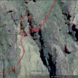 the Camels Back" title="Around the "Bad" section of