
Epic Day Hikes
I feel guilt about putting a No underneath that last, rather personal question but do not have a better answer to put in the details block below.
Ha Ha, presumably you're referring to the question about Medical Conditions, and presumably you're referring to your questionable mental state!!
An amazing achievement, not just for the speed of it all but also that you're pioneering new routes and strategies. Well done.
make a difference. today.
Please Log in or Create an account to join the conversation.
Thanks to you we can't really offer time estimates on this forum any more, or look at trails on the map in the same way.
Take nothing but litter, leave nothing but a cleaner Drakensberg.
Please Log in or Create an account to join the conversation.

Andrew Booth from KZN trail running has launched a page for FKT's (Fastest Known Times).
I told him about your Mafadi run so maybe that will go up on there.
Keen to give that run a go - it sounds amazing (have done Mnweni Marathon 5 times so if it's 50% harder than that it must be a really good day out!).
Good job.
Please Log in or Create an account to join the conversation.
- Andrew5336
-

- Offline
- Senior Member
-

- Posts: 30
- Thank you received: 4
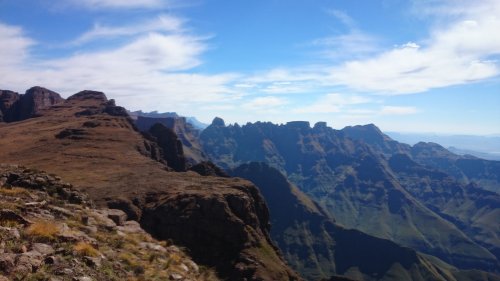
Went up from Monk's Cowl base to Blindman's Corner contour path junction and then around the real Blindman's Corner to get a view from the Injasuthi side of Monk's Cowl, Cathkin Peak and Champagne Castle.
21km in 5hrs, with a late start around 10am.
Breakfast Stream
Blindman's Corner - contour path junction
Right Side
Left Side
Looking in to Injasuthi area
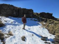
Remnants of Snow
Monk's Cowl Massif
Stats - mainly the elevation change, the highest elevation was towards the turn-around point on the contour path.
Please login or register to view the images attached to this post.
Please Log in or Create an account to join the conversation.

Please login or register to view the image attached to this post.
Please Log in or Create an account to join the conversation.
As I did this hike on 1 April though, I could probably justify posting it under recommended day hikes at Giants. My conscience would not let me sleep for weeks, so I am posting it here instead.
I left Giants at 4am, armed with a 20l bag that contained a few warm clothes, a rain coat, less than 1kg of food and more spare batteries for headlamp and GPS than the pack suggested necessary.
I headed up middle ridge. This is the first time I have been up the ridge and I found it really enjoyable. Moon light gave me glimpses of the view I was missing out on. I headed up South Jarding pass for 2 reasons: it got me to the right part of the escarpment, and as Ghaz says it has a lousy view, it is a good one to tackle in the dark.
Once on top, I spent a while looking at the view, and eyeing out options for the obvious "false" pass just to the south. I then teleported across to the Long Wall ridge and headed inland to bag Loteni Peak. I wanted to follow the ridge deep into Lesotho to bag Thaba Chitja and a few other high peaks.
But, I had a long way to go, and the path system in the Mokotlong valley is much faster. So, I dropped down and as it was early in the morning with a cool and pleasant headwind, I made really good time to the junction with the Tsolo river. Here, the long grind up to Thabana Ntlenyana begins.
There is a lovely spot where the path contours into the valley about midway up it. I have always stopped here for a sit down break and this was no exception. One difference though is that I had now covered about 35km already, and this was the first time I had anything to eat. A vast difference to the usual "eat every hour on the hour" rule I have used in the past.
I made good progress up the valley although by now the headwind had turned into gale force and was rather unpleasant. I was more tired than I should have expected and was also beginning to wonder about the wisdom of my no-food plan.
By the time I hit the Sani Flats, I was busy eating the last of my munchies. I avoided the temptation to take a sharp turn left, and continued towards the Pitsaneng valley. I tried something new, and it worked - I now have a foolproof and dog-free route through the area!
More importantly, by now I had realised the necessary truth to my no-eating plan. I had to slow down and keep my heart rate below 140 - as long as I did that, I felt fine. It felt wrong to power hike the fastest part of the route, but that was all I could do.
By the time I was heading up towards the No Mans ridge, the sun was well on its way down. Half way up the valley, I passed a kraal that has been occupied everytime I have been that way. Winter, summer and anytime between, it is occupied, sometimes even with women. The shepards saw my small bag, and considering the time of the day asked me inside for the night. I politely declined and continued.
I reached the top of Mashia Pass just before 7pm, and well after dark. I have only used this pass once before, getting hopelessly lost in some thick mist. I remembered doing some scrambles on wet rock in the center of the choss of the rockfall, and thinking I would hate to go down it. In the dark, it was a given that I lost the path in about 1 minute. I did better this time around, but I clearly need to do the pass in proper light one day to see where to go.
At the point where the path ends, and you reach the picnic area, a few headlights turned on. Ghaz and Hobbit and friends had come out to meet me. We walked together to Swiman hut, exchanging stories along the way. Ghaz as kindly offered to meet me here, bringing along a sleeping bag and supper so that I could do the trip with a light bag.
I clocked in at 84km, with 4700m altitude gain.
Thanks Ghaz for the assistance!
Footnote:
The next day, I did a loop up Bollard Pass, and down South Mzimude Pass. I had hoped to include peaks on the Lequoa Ridge, but sore feet and really strong wind stopped those silly ideas. The Mzimude Valley is a long exit with sore feet!
On day 3, I headed back up Mashai Pass, this time in better weather. I have not yet seen the Mashai Fangs as they were hidden in mist, but I did at least see and follow the path all the way up. I kept up the rule of a max heart rate of 140, and made it to Sani Top for another night. I bagged all the khulus along the way to ensure that I got in some solid hill training.
Day 4 was a bit longer and I did the haul back to Giants. This time, I hugged the escarpment, bagging those huge Vergelegen khulus along the way.
Each night, I ate a good meal provided by either Ghaz or from Sani Top. The 1kg of food I started out with provided the breakfast and all day-time food for those 4 days. There will be a story in this one day, but I still need a few weeks at least to sort this one out.
Highlights:
South Mzimude is my 50th pass
By bagging Redi, I have now reached the summits of all of the 3300m peaks in SA
I have now bagged all but 3 of the hiking peaks on Murch's khulu list: Tent, Hawk and KwaDuma are all that I have left
Please Log in or Create an account to join the conversation.
That wind up there on Saturday was quite bad....
Enjoyed the report...... Well done....
")

Please Log in or Create an account to join the conversation.

"We demand ...... a shrubbery!" - that was fun, although you may have been too tired to appreciate Monty Python referencesAndrewP wrote: At the point where the path ends, and you reach the picnic area, a few headlights turned on.

My pleasure!AndrewP wrote: Thanks Ghaz for the assistance!
My attempt to beat Andrew to all the non-technical khulus seems to be an uphill battle from hereAndrewP wrote: Highlights:
South Mzimude is my 50th pass
By bagging Redi, I have now reached the summits of all of the 3300m peaks in SA
I have now bagged all but 3 of the hiking peaks on Murch's khulu list: Tent, Hawk and KwaDuma are all that I have left
 I still have 18 to go.
Well done on the 50th pass and the final 3300+m peak
On a side note: I am going to go ahead and enjoy the last few weeks of being ahead of AndrewP on how many passes I have done

Please Log in or Create an account to join the conversation.

Please Log in or Create an account to join the conversation.
Walkers Ridge Pass/South Mzimude Pass loop: do you want to build a snowman?
It is easy to let opportunities slip you by in life. Sometimes you regret having not done something when you had the chance. Building a snowman is one of those clichés that comes out of movies, yet it seems to be one of those “must do” items that most people on this particular continent will never get to experience.
So Mike and I set off from Swiman Hut at 3:50AM, the goal being to head up Walkers Ridge Pass and down Mashai Pass – around 50km once a few peaks are thrown in.
We took our first break at Puffadder Rock, mostly just to fill up our bottles. We had averaged 5.2km/h to this point, reaching it in just over an hour.
First light hit around the middle of the Hidden Valley, and the sun had properly risen by the time we had just left the Hidden Valley. We stopped for our first proper break at 7, at Curtain Cave. 12km in 3h10 isn’t bad going, unless your goal is to pace yourself for a long day.
After having some breakfast and filling up our bottles for what we expected to be our last water before the Leqooa River, we set off up the gully between Curtain Cave and Wave Cave. This proved to be a good gradient route, but our fast start was taking its toll. It took over an hour to gain the 300m in altitude required to get to the top of the Walkers Ridge, so our pace had slowed considerably.
Walkers Ridge Pass is easy to describe – from the saddle where the pass starts (roughly where the ridge starts climbing after the low point where this gully tops out), follow the grassy north slope to an obvious saddle. A short scramble is found at the top of this, go up it, before following the top of the ridge to the 2926m peak shown on the map. Walk to the far side of this peak, scramble down an easy and obvious gully before traversing below a few cliffs. Once you are obviously past all the gaps, take any line you like up the very wide grassy slopes until you hit either the top of the gully by Corn Cob Cave, or until you are on the escarpment. For that matter, you could even traverse out towards Andre’s Knob and head down Isicutula Pass.
The ridge holds a nice gradient most of the way, and affords some really good views. The 2926m peak has some great views. Dave G’s GPS track showed that we should have traversed lower rather than going up this peak, but the 30m in extra altitude and bypassing a scramble definitely made for a worthwhile variation. We found an easy gully to scramble down before traversing below the cliffs.
The melting snow meant that there was flowing water right up to 3050m on the pass, which was very helpful. We bagged Walkers Pass Peak (3091m, 51m prominence) – Mike’s 99th khulu, before heading up to the escarpment to find massive fields of snow.
We had decided to try for Thamathu and Morake – 2 long standing goals of mine. These Lesotho peaks of 3328m and 3335m respectively are very impressive from a distance, and equally daunting when you decide to climb them!
We found some snow, and decided to build mini-snowmen. Amazing how much snow is needed for this!
We then proceeded to start walking around Walkers Peak, where we found some massive fields of snow. We discussed it for about 8 seconds before it was obvious that we were both thinking the same thing – we can always come back and climb these peaks, but it is very difficult to actually find the right conditions to build a snowman (well, in Southern Africa anyway).
Some lessons learned about building snowmen:
1. Powder snow that is compacted by hand goes very hard, so be careful where you place your snow
2. The middle and top sections don’t always stick to the base quite as you expect. It is amazingly easy to accidentally destroy your snowman during construction
3. Those perfectly round snowmen seen in movies are either very hard to achieve, or we need to watch a youtube instructional video explaining how to build a snowman
4. Building a snowman takes a lot of time, even with 2 people working together
5. Even with gloves on, your hands will be frozen by the end of it
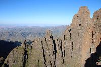
By the time we were done with this, it was almost 2PM already. Time well spent, but we were running late. Mist was also beginning to move in as we motored it to Thamathu. We stood on top of the peak as the mist rolled in, with it briefly clearing for summit shots just before we moved off the top.
We knew the ship had sailed on Morake (which is quite far from Thamathu), and with the mist and cold wind, we knew how exposed we were with day packs – so we motored it from here to the top of Mzimude South Gully, only taking a break once we were 100m vertically down the pass.
We got down the pass quite quickly – got to love wide grassy passes, even without a trail you can get down them quite quickly when you need to. We traversed across a small Berg ridge, and dropped over the top towards the trail that leads to Curtain Cave. As well as I know this particular region of the Berg, I really didn’t want to navigate it in the dark or mist – so I was relieved when we eventually hit the trail with 30 minutes to go before sunset. It had been raining for about an hour, but had stopped before we hit the trail.
We took a break at the top end of the Hidden Valley before deciding to motor the end of the hike. We had 10km to go, and at 4:55PM we began the long walkout to Swiman Hut. With 2 breaks amounting to about 20 minutes in total, we managed to get back to Swiman Hut by 7:10PM.
So we didn’t achieve everything we set out to do, but we knocked off 3 summits that neither of us had done before – a khulu, a kgolo and an arbitrary peak that may have never been climbed before, I got a pass I hadn’t done, and Mike got to knock off 2 he hadn’t done. The fact that we got to build our first snowman more than makes up for what we missed in summits. I could also live with not hiking through the Hidden Valley again! It is a great spot, but I have done it so many times now.
Our stats for the day:
Distance: 40km
Altitude gain and loss: 1920m
Total time: 15h20
Average speed: 2.6km/h
Average moving speed: 3.3km/h
Please Log in or Create an account to join the conversation.
