
Jonkershoek Marathon
27 Oct 2015 11:11 - 27 Oct 2015 11:55 #65537
by AndrewP
Jonkershoek Marathon was created by AndrewP
I recently took a holiday to the Western Cape. I spent numerous days in the hills, one of which was a trip into the Jonkershoek Valley, just outside Stellenbosch, with Sarah. She enjoyed the flowers, which were in full bloom. Due to the fires in March they were visible as fields of flowers. I can only look at flowers for so long, and my eyes caught the ridge line surrounding the valley. It is possible to traverse the ridge on a route known as the Jonkershoek Marathon. One look and I was sold.
The ridgeline as seen from below, or if you prefer, a field of flowers.
The Jonkershoek Marathon is a 30km challenge following this horseshoe shaped ridge. Coos Diener has described it well on the FEAT website and he also gave a good account of one of his attempts, at:
www.extremelights.co.za/jonkershoek-marathon-personal-attempt-unthinkable/
A very quick summary follows. The route was first done 50 years ago putting an FKT in the ground before most trail runners were born. The current FKT of 9:40 was set in 2000. The route is very technical with desperate route finding, scrambling (I found an MCSA journal article that puts parts of it and grade D to E), big exposure and over 3000m altitude gain and loss. Needless to say the recommendations are to scout out the route in sections, to work out possible escape routes and to not attempt it solo. The route starts and finishes on the first and last summits so you need about 3 hours extra to complete the loop. Importantly all of the records have been set by someone living in Stellenbosch.
I ignored all of this and decided to try onsight it. i.e. climbing term - first attempt with no knowledge at all about the route other than what you work out as you go. Not knowing anything, I had to wait until it was light to set off, to finish before dark and had to allow for as many as 4 hours to escape the ridge if I chose to bail. It also meant I would have to negotiate several almost vertical drops of over 200m into nothingness. Balls to the wall stuff. I would have to go at almost record pace just to finish.
I say onsight but actually I knew the following. To get to the start you have to escape the roads through wine farms and electric fences. Ditto for the finish. So, for this I asked the locals. Also the map on my GPS showed a path in the midsection and hence a possible escape there and I knew there was water somewhere on the path. So, not a pure onsight, but as close as you will ever get.
Getting to the start was tricky. I could not find the farm road I had been directed towards. Tony though had an idea and dropped me off in Stellenbosch itself next to a park with a forest leading out of town. I set off at about 6:10, already 25 minutes late.
I quickly found a path which took me to a forestry road heading directly towards the start, Bosmas Kop. A few twists and turns and obvious choices at road or path splits took me directly towards the summit. 800m vertical on the legs and an hour later I had made it to the start. I spent a few minutes putting on sunblock, drinking my extra water and communicating back home that it was time to set off. I obviously did all of this before starting the clock.
The first 2 hours went smoothly despite a few big hills and some minor route choice errors. The only mistake so far was the poor choice of short pants. Fynbos is lethal.
I messed up the descent off Pieke and some sketchy grass and rock traverses led me to an easier gully heading down to the nek. I could have saved 15 minutes by just going down the correct gully in the first place but that kind of thing is always easier with hindsight. Especially if you can now look back at the slopes your tried going down. I mostly got the 300m climb to Rifberg right but definitely lost the cairns for a while and just improvised with a long scramble when the cairns died out. I sent another message home and pressed on.
This time around I found the cairns and a very involved descent took me down to the next nek, around a gendarme and across some exposed ledges to a gully heading up. By now, I was really enjoying myself. The views are impressive, you often follow knife-edge ridges and I had to concentrate very hard on my navigation. I even stopped for a few photos. The Western Cape has some impressive mountains – they are steep, rugged and very 3D. Snaking your way through them is a treat.
The terrain is rather complex to navigate through
I got through to the second and then third ridge peaks easily enough and sent another message home. At this point the really hard navigation seems to be over and I expected a fast cruise home.
The hopelessly inaccurate contours on my GPS based map and some sloppy route finding on my part took me on a detour that could be described as scenic (it really was beautiful out there). Some people may have concentrated on the sketchy grass traverses above waterfalls, but as they say, “what goes in Jonkershoek stays...” My legs though noticed that I was off route by the simple amount of pain needed to thrash through the fynbos.
Eventually I hit the path running around the head of the valley. I dug deep to make up some lost time. At this point, I still felt the record was in sight but it depended on the time I would need after leaving the path to approach the final climb to Haelkop.
As it turned put this is almost impossible to onsight efficiently so I got lost on steep traverses on loose stones and caught between rock bands. Several times. It did not help either that it was now the warmest part of the day and that I was on a north facing slope. The going was hard and for a while was not much fun either.
I eventually broke through the mess and reached the nek before Haelkop, the last big pull before the expected “downhill sprint” to the finish at Stellenbosch Peak.
I made my way up through the first set of rock bands to get onto a steep ridge heading for the summit. I drank a bit of water on the final approach and was greeted by the slurping sounds of an empty bladder. Approaching the summit I put together a quick action plan. I would first check on my GPS that I was indeed in the right place. I would mark the summit with a waypoint and I would send a quick message home.
The GPS check suggested something may be wrong but on steep ground a GPS is often a bit out. I did not worry too much and carried on pushing hard to the summit.
Where it all fell apart.
I had reached a false summit 200m vertical below the true summit with some huge rock bands stretching in every direction.
With my only option being to drop 200m back to the nek and then another 200m down followed by 1km of bundu bashing in thick fynbos I was understandably a bit demoralised. I stared at nothing in particular for about a minute and resisted saying anything unpublishable. Maybe I was too tired for that.
Fortunately at the last moment I saw a 2 stone cairn. It led nowhere but suggested I might not be as lost as I had thought. I found a chimney that lead to a gully that broke through the next rock band. Lots of scrambling above finally got me to the summit. I sent home my first message in ages and reset my goal on now finishing with a smile on my face.
I could not eat without water to wash it down so the haul across to Stellenbosch Peak was long. Dodgy contours on the GPS resulted in it being a lot harder than I had expected but I finally reached the summit 10:37 after setting off. I had missed the fastest time, but had a Flippen Kief Time instead.
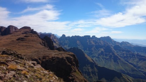
From the finish, looking back at the first few peaks
From here it was a long haul down the ridge with no food or drink into the setting sun. I made it back without using my headlamp out of principal but let’s be honest: 15 min before finishing, I noticed a feint shadow from the moon. I ended up taking an amazingly direct line though the final forests by pure coincidence and shortly before 8 I reached a car park that just happened to be the same one Tony was waiting in.
Stats for the complete trip come out as:
4160m altitude gain
4180 down
42.5 km covered
Too many scratches to count
The true test of an epic day out is the answer to the question “will you do it again?”
Immediately afterwards: Hell no
The next morning: Maybe but not for a long time
Lunchtime. Definitely. About to book my plane ticket!
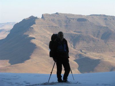
Proof of a good day out
It ranks up there as one of the best days I have ever had in the hills. Tough. Demanding. Very scenic. Lots of fun. Totally worth it.
The ridgeline as seen from below, or if you prefer, a field of flowers.
The Jonkershoek Marathon is a 30km challenge following this horseshoe shaped ridge. Coos Diener has described it well on the FEAT website and he also gave a good account of one of his attempts, at:
www.extremelights.co.za/jonkershoek-marathon-personal-attempt-unthinkable/
A very quick summary follows. The route was first done 50 years ago putting an FKT in the ground before most trail runners were born. The current FKT of 9:40 was set in 2000. The route is very technical with desperate route finding, scrambling (I found an MCSA journal article that puts parts of it and grade D to E), big exposure and over 3000m altitude gain and loss. Needless to say the recommendations are to scout out the route in sections, to work out possible escape routes and to not attempt it solo. The route starts and finishes on the first and last summits so you need about 3 hours extra to complete the loop. Importantly all of the records have been set by someone living in Stellenbosch.
I ignored all of this and decided to try onsight it. i.e. climbing term - first attempt with no knowledge at all about the route other than what you work out as you go. Not knowing anything, I had to wait until it was light to set off, to finish before dark and had to allow for as many as 4 hours to escape the ridge if I chose to bail. It also meant I would have to negotiate several almost vertical drops of over 200m into nothingness. Balls to the wall stuff. I would have to go at almost record pace just to finish.
I say onsight but actually I knew the following. To get to the start you have to escape the roads through wine farms and electric fences. Ditto for the finish. So, for this I asked the locals. Also the map on my GPS showed a path in the midsection and hence a possible escape there and I knew there was water somewhere on the path. So, not a pure onsight, but as close as you will ever get.
Getting to the start was tricky. I could not find the farm road I had been directed towards. Tony though had an idea and dropped me off in Stellenbosch itself next to a park with a forest leading out of town. I set off at about 6:10, already 25 minutes late.
I quickly found a path which took me to a forestry road heading directly towards the start, Bosmas Kop. A few twists and turns and obvious choices at road or path splits took me directly towards the summit. 800m vertical on the legs and an hour later I had made it to the start. I spent a few minutes putting on sunblock, drinking my extra water and communicating back home that it was time to set off. I obviously did all of this before starting the clock.
The first 2 hours went smoothly despite a few big hills and some minor route choice errors. The only mistake so far was the poor choice of short pants. Fynbos is lethal.
I messed up the descent off Pieke and some sketchy grass and rock traverses led me to an easier gully heading down to the nek. I could have saved 15 minutes by just going down the correct gully in the first place but that kind of thing is always easier with hindsight. Especially if you can now look back at the slopes your tried going down. I mostly got the 300m climb to Rifberg right but definitely lost the cairns for a while and just improvised with a long scramble when the cairns died out. I sent another message home and pressed on.
This time around I found the cairns and a very involved descent took me down to the next nek, around a gendarme and across some exposed ledges to a gully heading up. By now, I was really enjoying myself. The views are impressive, you often follow knife-edge ridges and I had to concentrate very hard on my navigation. I even stopped for a few photos. The Western Cape has some impressive mountains – they are steep, rugged and very 3D. Snaking your way through them is a treat.
The terrain is rather complex to navigate through
I got through to the second and then third ridge peaks easily enough and sent another message home. At this point the really hard navigation seems to be over and I expected a fast cruise home.
The hopelessly inaccurate contours on my GPS based map and some sloppy route finding on my part took me on a detour that could be described as scenic (it really was beautiful out there). Some people may have concentrated on the sketchy grass traverses above waterfalls, but as they say, “what goes in Jonkershoek stays...” My legs though noticed that I was off route by the simple amount of pain needed to thrash through the fynbos.
Eventually I hit the path running around the head of the valley. I dug deep to make up some lost time. At this point, I still felt the record was in sight but it depended on the time I would need after leaving the path to approach the final climb to Haelkop.
As it turned put this is almost impossible to onsight efficiently so I got lost on steep traverses on loose stones and caught between rock bands. Several times. It did not help either that it was now the warmest part of the day and that I was on a north facing slope. The going was hard and for a while was not much fun either.
I eventually broke through the mess and reached the nek before Haelkop, the last big pull before the expected “downhill sprint” to the finish at Stellenbosch Peak.
I made my way up through the first set of rock bands to get onto a steep ridge heading for the summit. I drank a bit of water on the final approach and was greeted by the slurping sounds of an empty bladder. Approaching the summit I put together a quick action plan. I would first check on my GPS that I was indeed in the right place. I would mark the summit with a waypoint and I would send a quick message home.
The GPS check suggested something may be wrong but on steep ground a GPS is often a bit out. I did not worry too much and carried on pushing hard to the summit.
Where it all fell apart.
I had reached a false summit 200m vertical below the true summit with some huge rock bands stretching in every direction.
With my only option being to drop 200m back to the nek and then another 200m down followed by 1km of bundu bashing in thick fynbos I was understandably a bit demoralised. I stared at nothing in particular for about a minute and resisted saying anything unpublishable. Maybe I was too tired for that.
Fortunately at the last moment I saw a 2 stone cairn. It led nowhere but suggested I might not be as lost as I had thought. I found a chimney that lead to a gully that broke through the next rock band. Lots of scrambling above finally got me to the summit. I sent home my first message in ages and reset my goal on now finishing with a smile on my face.
I could not eat without water to wash it down so the haul across to Stellenbosch Peak was long. Dodgy contours on the GPS resulted in it being a lot harder than I had expected but I finally reached the summit 10:37 after setting off. I had missed the fastest time, but had a Flippen Kief Time instead.
From the finish, looking back at the first few peaks
From here it was a long haul down the ridge with no food or drink into the setting sun. I made it back without using my headlamp out of principal but let’s be honest: 15 min before finishing, I noticed a feint shadow from the moon. I ended up taking an amazingly direct line though the final forests by pure coincidence and shortly before 8 I reached a car park that just happened to be the same one Tony was waiting in.
Stats for the complete trip come out as:
4160m altitude gain
4180 down
42.5 km covered
Too many scratches to count
The true test of an epic day out is the answer to the question “will you do it again?”
Immediately afterwards: Hell no
The next morning: Maybe but not for a long time
Lunchtime. Definitely. About to book my plane ticket!
Proof of a good day out
It ranks up there as one of the best days I have ever had in the hills. Tough. Demanding. Very scenic. Lots of fun. Totally worth it.
Please login or register to view the images attached to this post.
Last edit: 27 Oct 2015 11:55 by AndrewP. Reason: Add Pictures
The following user(s) said Thank You: elinda, Stijn, jamcligeo, Frosty Ice, firephish, ghaznavid, Smurfatefrog, tonymarshall, Viking, ASL #Bivak, AdrianT, andrew r, saros, biomech, Coeta
Please Log in or Create an account to join the conversation.
27 Oct 2015 12:19 #65539
by elinda
Replied by elinda on topic Jonkershoek Marathon
Fantastic effort and write up Andrew! I look forward to reading about your next attempt 
Please Log in or Create an account to join the conversation.
27 Oct 2015 21:03 #65543
by Stijn
Replied by Stijn on topic Jonkershoek Marathon
Good job Andrew - and thanks for the write-up. 
That Jonkershoek Valley is just brilliant, isn't it? The Central Kloof scrambling route up the Jonkershoek Twins, coming down via Nerina Kloof must be one of my favourite routes on any peak, anywhere!
That Jonkershoek Valley is just brilliant, isn't it? The Central Kloof scrambling route up the Jonkershoek Twins, coming down via Nerina Kloof must be one of my favourite routes on any peak, anywhere!
Please Log in or Create an account to join the conversation.

27 Oct 2015 21:10 #65544
by intrepid
Take nothing but litter, leave nothing but a cleaner Drakensberg.
Replied by intrepid on topic Jonkershoek Marathon
Another fine page in Andrew's "I just feel bored sometimes" scrap-book.
Take nothing but litter, leave nothing but a cleaner Drakensberg.
Please Log in or Create an account to join the conversation.

29 Oct 2015 11:01 #65561
by Andrew5336
Replied by Andrew5336 on topic Jonkershoek Marathon
Awesome, I have friends who stay in the valley and they have done it a few times.
Hope to get proper fit and join them next one!
Hope to get proper fit and join them next one!
Please Log in or Create an account to join the conversation.
- Andrew5336
-

- Offline
- Senior Member
-

Less
More
- Posts: 30
- Thank you received: 4
29 Oct 2015 13:17 #65563
by andrew r
make a difference. today.
Replied by andrew r on topic Jonkershoek Marathon
Well done, thanks for a great report; I'd say you are a machine but machines don't have such an amazing sense of humour when put to the test ")
make a difference. today.
Please Log in or Create an account to join the conversation.
05 Oct 2016 15:39 #69958
by AdrianT
Replied by AdrianT on topic Jonkershoek Marathon
I see there is a new FKT now of 08:35:58. I think most of us would be pleased to do this in a day! Respect to all of you!
www.redbull.com/za/en/adventure/stories/1331819955667/ryan-sandes-andre-gie-and-kane-reilly-jonkershoek-fkt
www.redbull.com/za/en/adventure/stories/1331819955667/ryan-sandes-andre-gie-and-kane-reilly-jonkershoek-fkt
Please Log in or Create an account to join the conversation.
01 Dec 2016 11:19 #70295
by lightee
Replied by lightee on topic Jonkershoek traverse
Hi Andrew
I wanted to ask a favor. Can you (or anyone on this thread) please send me a link with the GPS file if possible. We are doing the traverse in a week or so and we have a rough idea as one guy has done it but would feel good to have a basic route.
Let me know thanks a lot
Clint (This email address is being protected from spambots. You need JavaScript enabled to view it.)
Please Log in or Create an account to join the conversation.

29 Nov 2017 13:02 #72423
by AdrianT
Replied by AdrianT on topic Jonkershoek traverse
And there is a new FKT time again as of yesterday (28 November 2017). Robyn Kime (Owen), Lance Kime and Davie Krone (according to Instagram not sure if his name is accurate).
08:09.
08:09.
Please Log in or Create an account to join the conversation.
03 Dec 2017 14:19 - 03 Dec 2017 14:21 #72436
by Vynbos
Replied by Vynbos on topic Jonkershoek traverse
I'm also hoping to get hold of the gps track, please, DM me for my email.
Last edit: 03 Dec 2017 14:21 by Vynbos. Reason: ?
Please Log in or Create an account to join the conversation.
