
Cathedral Peak hikes - 4 days or longer
Redshift3 wrote: via Organs Pipe Pass & Windy Gap
I assume you mean Thuthumi Ridge and Organ Pipes Pass - Windy Gap is on the Camel Route. The trails join just above that.
Redshift3 wrote: • Up the Camel’s Back was hectic, is down a good idea?The problem is the last day we need to back at the vehicles by latest 15H00 in order to motor home Sunday night.
If you have done the route before, why not consider Thuthumi Pass or Smugglers Pass? These routes are usually avoided due to the slog to get over Ndumeni Dome, but Rolands Cave is above Thuthumi Pass, and you are basically over to get to Smugglers. Both can be connected up to the Thuthumi Ridge/Old Fire Lookout route via a connecting trail. I haven't done the bit from the connecting trail down to the Nek (the more obvious line for Thuthumi Pass), but I believe you hit the contour path above Philip's Folly - so it would also be an option.
Also - the Thuthumi Ridge route on Organ Pipes vs the Camel means you start and finish at different places. You can do Camel via Tryme Hill (as far as I know, I haven't done this myself), but you will still have to walk quite a bit of tarred road at the start or end of the hike.
Redshift3 wrote: • Mikes pass, who and how do we get transport from Didima to the gate at the end of Mikes Pass, either on day one or the last day? Is there someone we can pay/hire to pick up or drop off? We can slog it from Didima to Fire lookout but it’s also a travel day so we can only hit the trail by 12H00?
If you find the right person in the office - let me know! I have asked many times with no luck.
Please Log in or Create an account to join the conversation.

Also be aware that the campsite (& ablutions) at Didima are closed indefinitely for renovations, see VE discussion here .
make a difference. today.
Please Log in or Create an account to join the conversation.
The one section on the Camel route that is "fairly exposed" you need to take care on regardless of whether you are heading up or down
I headed up and down that route to the organ pipes pass in Dec with a light pack, and it was very manageable.
We will be there again before May and I can confirm again what it is like then, just remind me.
Please Log in or Create an account to join the conversation.

Can anyone tell me in what condition the Old Fire Lookout really is? I know it is all broken down, but is the roof totally gone? And is the Jojo still there?
Much appreciated!
Please Log in or Create an account to join the conversation.
- petroengel
-
- Offline
- Senior Member
-

- Posts: 52
- Thank you received: 15
Please login or register to view the image attached to this post.
Please Log in or Create an account to join the conversation.
- Smurfatefrog
-

- Offline
- Moderator
-

- Posts: 1132
- Thank you received: 1550
Please Log in or Create an account to join the conversation.

Thanx Riaang your input is always appreciated.
Regards,
Redshift3
“You need special shoes for hiking — and a bit of a special soul as well.”
Terri Guillemets
Please Log in or Create an account to join the conversation.
If heading north along contour path then the Ndumeni river is not far from the base of the ridge
Not sure if you're not aware of the spring on the pass around 2500m, if not then fill up there
Please Log in or Create an account to join the conversation.
- Smurfatefrog
-
- Offline
- Moderator
-
- Posts: 1132
- Thank you received: 1550
Please excuse my ignorance

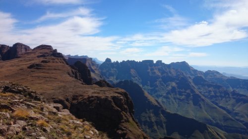
Attached is a Google Earth screenshot of my intended route on for the first weekend in May. We are a tad tight on time, hence some advice.
I’m OK with the first leg from the Cathedral Peak Hotel overnighting at the top of Ribbon Falls (we going to get a late start and I know there is water there for the first night). The next morning early up the Camel drop into the main Organ Pipes route to the top Cairn and into Roland’s Cave (Yellow and Pink route on my pic). I should be OK up until this point as I completed this exact route last year during the rainy season.
My confusion and questions are more after Roland’s Cave
 . We need to get down and back to Didima in one and half days (need to leave Didima by 14H00ish on the Sunday to get back home for work on Monday). The Green and Blue route is one I have copied from other users, with an overnight at or near the Fire Lookout or closer to Didima allowing for a short last day back to Didima:hike:
My questions are as follows, is this the fastest way back down from Roland’s to Didima?
I’m still a bit confused as to where the “Windy Gap”, “Mikes Pass” and “Thuthumi Ridge" are, would it be possible for someone to indicate on a map or GE (or co-ords)where the main features everyone refers to are? This way I can orientate myself on the map and on the ground. And if possible the places to perhaps find water.
The good news is that Didima Camp is open again so we can hire a campsite and use the ablutions before hitting the road home on Sunday.
Any suggestions would be welcome.

“You need special shoes for hiking — and a bit of a special soul as well.”
Terri Guillemets
Please login or register to view the image attached to this post.
Please Log in or Create an account to join the conversation.
If I was you I'd head down the pass completely and stay at or around the old staff buildings.
Then head down Mike's Pass.
Windy Gap is a small gap near the top of the Camel route
Thuthumi ridge is the ridge that the hut is on (the lower part of your green path)
Mike's Pass is a road heading down (the lower half of your blue path)
Please Log in or Create an account to join the conversation.
- Smurfatefrog
-
- Offline
- Moderator
-
- Posts: 1132
- Thank you received: 1550
