
Makhaza GPS Coordinates
30 Jun 2022 07:56 #77841
by Pirot
Makhaza GPS Coordinates was created by Pirot
Good day everyone, I'm goin to hike up to Giants Castle tomorrow, (Friday 30th June) does anyone have the gps coordinates for makhaza waterfall, or just an Google image of the position please?
Thanks
Thanks
Please Log in or Create an account to join the conversation.

30 Jun 2022 09:43 - 30 Jun 2022 09:44 #77842
by Smurfatefrog
Replied by Smurfatefrog on topic Makhaza GPS Coordinates
Here we go, tomorrow is Friday 1 July BTW
This image is hidden for guests.
Please login or register to view the image attached to this post.
Last edit: 30 Jun 2022 09:44 by Smurfatefrog.
Please Log in or Create an account to join the conversation.
- Smurfatefrog
-

- Offline
- Moderator
-

Less
More
- Posts: 1134
- Thank you received: 1551
30 Jun 2022 09:59 #77843
by Pirot
Replied by Pirot on topic Makhaza GPS Coordinates
Thanks you very much, I appreciate it!! Have a great day, I will post some photos after the weekend
This image is hidden for guests.
Please Log in or Create an account to join the conversation.
30 Jun 2022 14:13 #77845
by Riaang
Replied by Riaang on topic Makhaza GPS Coordinates
@Pirot,
Let me give you a very easy route description of how to get to it.
Once you top out on Giants pass, walk forward maybe 50m or so where you will see a footpath in front of you which runs perpendicular to your direction of travel.
Turn LEFT onto this path.
Follow this path for about 1.4km or so.
You will walk right pass Makhaza which will be on your right.
It is literally just on the other side of Giants castle from your starting point on the footpath, i.e. when you top out on Giants pass, it is directly to your left - Giants Castle itself stands between you and Makhaza.
Please Log in or Create an account to join the conversation.

08 Apr 2026 10:50 #80318
by petroengel
Replied by petroengel on topic Makhaza GPS Coordinates
Does anyone have a photo of Makhaza? I assume with all the rain this year that it might be quite marshy in the waterfall's vacinity?
Please Log in or Create an account to join the conversation.
- petroengel
-
- Offline
- Senior Member
-

Less
More
- Posts: 52
- Thank you received: 15
08 Apr 2026 11:24 - 08 Apr 2026 11:26 #80320
by Riaang
Replied by Riaang on topic Makhaza GPS Coordinates
We went up Langies this weekend and down Bannermans, so quite near to Giants. While there was water in all the streams, I found the velt itself surprisingly dry. Yes, that area around Makhaza can absolutely be very marshy and we've battled to find a high and dry camping spot in those conditions before (tip: closer towards Elandshoek pass we found some higher ground, if I remember correctly maybe 200m max from the passhead, probably less and about 5m directly below the path).
It's kind of like the sun evaporated a lot of the surface water but there was plenty of water in the streams. It was super hot this weekend, my watch registered 40 Deg C below Bannermans cave as we were pitching the tents. Not a cloud in the sky and virtually no wind blowing. Lots of condensation in the tent (double wall) even though it was so warm on Friday night I slept on top of my sleeping bag. I think this has probably been one of the hottest hikes I've ever done in the berg, and there has certainly been some hot ones in the past. The no wind made it tough for me, I basically had to walk faster to create a breeze!!!! One of the guys in our group commented that it felt like he was touched by a solar flare") and I kind of have to agree with him.
and I kind of have to agree with him.
It's kind of like the sun evaporated a lot of the surface water but there was plenty of water in the streams. It was super hot this weekend, my watch registered 40 Deg C below Bannermans cave as we were pitching the tents. Not a cloud in the sky and virtually no wind blowing. Lots of condensation in the tent (double wall) even though it was so warm on Friday night I slept on top of my sleeping bag. I think this has probably been one of the hottest hikes I've ever done in the berg, and there has certainly been some hot ones in the past. The no wind made it tough for me, I basically had to walk faster to create a breeze!!!! One of the guys in our group commented that it felt like he was touched by a solar flare
and I kind of have to agree with him.
Last edit: 08 Apr 2026 11:26 by Riaang.
Please Log in or Create an account to join the conversation.
08 Apr 2026 13:14 #80321
by petroengel
Replied by petroengel on topic Makhaza GPS Coordinates
Eish, that kind of heat in the Berg!! Glad you could sweat it out a bit
Thanks for all the info.
This image is hidden for guests.
Thanks for all the info.
Please Log in or Create an account to join the conversation.
- petroengel
-
- Offline
- Senior Member
-
Less
More
- Posts: 52
- Thank you received: 15
08 Apr 2026 15:44 - 08 Apr 2026 15:50 #80325
by petroengel
Replied by petroengel on topic Makhaza GPS Coordinates
So, pardon me, but do I understand correctly? X marks Makhaza? I'm strugling to get a picture in my head as to the topo. And, I always wonder how a landmark people refer to is not on a map... my bad!!
Thank you all!!
Thank you all!!
Please login or register to view the image attached to this post.
Last edit: 08 Apr 2026 15:50 by petroengel. Reason: Photo attached wrong
Please Log in or Create an account to join the conversation.
- petroengel
-
- Offline
- Senior Member
-
Less
More
- Posts: 52
- Thank you received: 15
08 Apr 2026 16:29 #80328
by Smurfatefrog
Replied by Smurfatefrog on topic Makhaza GPS Coordinates
Nope, here we go
Please login or register to view the image attached to this post.
Please Log in or Create an account to join the conversation.
- Smurfatefrog
-
- Offline
- Moderator
-
Less
More
- Posts: 1134
- Thank you received: 1551
09 Apr 2026 10:56 - 09 Apr 2026 10:57 #80332
by Riaang
Replied by Riaang on topic Makhaza GPS Coordinates
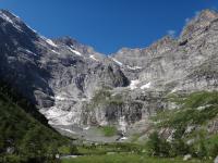
You can clearly see Makhaza from the path, it's about mmmm say 30m below the path.
Once you top out at Giants pass, go down maybe 100m and turn left on the path. Go around Giants Castle while following the path, while walking towards Elandshoek pass. Makhaza is on your right, towards the drop-off.
The only way you can possibly miss it is in thick mist or rain, it is very visible. This time of year probably just black rock, mid winter nice and white with ice.
Last edit: 09 Apr 2026 10:57 by Riaang.
The following user(s) said Thank You: petroengel
Please Log in or Create an account to join the conversation.
