Vergelegen hikes - 4 days or longer
02 Oct 2012 07:51 #55362
by intrepid
Take nothing but litter, leave nothing but a cleaner Drakensberg.
Replied by intrepid on topic Vergelegen hikes - 4 days or longer
While I haven't done all the daily segments you intend to do, here are some of my thoughts:
Day 1 sounds fairly long for a first day...havent walked this ridge though. Have you considered transport logistics, since there is no obvious start to the ridge from Vergelegen. It may be easier following the river to the cave.
For a more circular route, you could consider heading up Mlahlangubo Pass on the first day, which is quite manageable. Its an easy pass. Then across to either Nhlangeni or kaNtuba Pass. The latter is a very high pass and pretty long. You can still spend a night in Birds Nest and then head across to Khuala Cave. I would prefer to walk Burnera Ridge out, rather than in. This does leave out the rock arch though, but it is less of a criss-crossed route.
Take nothing but litter, leave nothing but a cleaner Drakensberg.
The following user(s) said Thank You: mikedexter
Please Log in or Create an account to join the conversation.

03 Oct 2012 19:03 #55372
by mikedexter
Replied by mikedexter on topic Vergelegen hikes - 4 days or longer
I know what you mean about day 1. I hadn't had a close look at the contours between the office and the Burnera Ridge, now I see that it might add a fair bit of time and difficulty. I really like the look of the path below the saddle to the rock arch so would like to keep it in if possible. I'm thinking now that following the river to Birds Nest cave for night 1 and then to the rock arch for night 2 might be a better option. From there head up Mlahlangubo Pass. Couple nights on top and down Nhlangeni pass to Khuala cave. From there either Burnera ridge or the valley back to office depending on how we feel by that stage. The ridge looks to be a few km longer + the bundu bashing at the end.
Please Log in or Create an account to join the conversation.
- mikedexter
-
 Topic Author
- Offline
- New Member
-

Less
More
- Posts: 9
- Thank you received: 9
23 Oct 2012 12:50 #55497
by mikedexter
Replied by mikedexter on topic Vergelegen hikes - 4 days or longer
Right, so...
Early in the wet misty morning of 9 October my fiance and I headed out from the Vergelegen camp site with a week's worth of food, a sound route in mind and optimism for good weather in our hearts.
Well, we only used half the food, the route fell to pieces and our optimism didn't pay off
On day 1 we headed up the Mkhomazi river to Birds Nest cave. It was a pleasant walk and we had a few glimpses of reassuring blue sky through the otherwise impenetrable grey blanket that hid most of the little berg from site. We lost the path in the indigenous forest about 500m from the cave and it took us an hour to cover that distance. The cave itself was fine and kept us dry through a wet and thunderous night.
The plan for day 2 was to take the path along the ridge NW of the cave towards Mkhomazi pass. At the base of the pass we were to follow the contour path East to the Evranda Rock Arch. The day started out well although there was low cloud and intermittent drizzle. We couldn't find the point where the path crossed the river but we knew it ran along the top of the ridge so decided to look for it there. It was a bit of a climb for us (450m)but by the time we reached the ridge the clouds had lifted and we had some beautiful views of King Kong and the Saddle. We soon picked up a vague path and followed it for a few hundred meters until it petered out into nothing. I know this happens a lot in the berg so I was confident we'd pick it up again later if we stuck to the same contour along the ridge. I was wrong. We did come across patches of path but nothing that we could follow for more than a few minutes. Looking north over the Mkhomazi valley I spotted a prominent rock arch on the eastern ridge of the saddle. It matched the position of the Evranda rock arch on the map, that was where we were headed and we clearly had a long way to go. A little later though we noticed another arch, this one directly below the saddle and MASSIVE! Confusion set in and, rather than consult the map again, we assumed that we'd been mistaken, misread the map and that this new arch was our planned destination. We decided to cross the Mkhomazi at the confluence with the stream that runs from the gully between King Kong and Nhlangeni Peak. From there it was a steep, wet, ankle twisting traverse to the arch which turned out to be very impressive. By the time we arrived though the wind had picked up, the rain was pelting down and all we wanted to do was climb into the tent. It was a hairy night on a pretty exposed campsite with lightening striking the high peaks around us and the wind putting our brand new tent to the test (it passed). At 2600m we were directly below the imposing cliffs of the Saddle; neither of us slept much that night.
On day 3 we were heading to Mlahlangubo pass. It was due to be a shortish day so we had a later start and after half an hour of more ankle twisting we spotted a path in the distance") It wasn't the best path in the world but it made the going just that much easier. The sun came out, the wind dropped and all was fine and dandy After a a couple of hours at a steady pace and still no sign of the pass we started having doubts about our position. Some dark clouds were also moving into the little berg valleys below us. Eventually though we did find an obvious and easy enough looking pass which we assumed to be Mlahlangubo. The wind had now picked up, the clouds were climbing towards us and Ali was experiencing a lot of pain in one ankle. If we headed up the pass we'd have 3 more nights in potentially deteriorating weather. If we headed East down the ridge we could overnight in runaway cave and be back in camp the next day. We chose the latter option. It wasn't long though before we realised that we might be on the wrong ridge but the presence of a path, a decent path, reassured us. The path, once again, didn't last long and we were soon trudging through heavy rain and thick mist, crisscrossing the river at every hint of a trail. Eventually though, at 18:00 the light was fading and we called it a day. Finally out of the rain, we minutely examined the map and eventually found our position. We were in the Mlahlangubo Omcane valley, not the Mlahlangubo omkhulu as we had thought. That meant we had never reached Mlahlangubo pass and the one we had seen must have been Ngaqamadola. This then meant that the Evranda rock arch on the map must refer to the small insignificant arch on the ridge from the Saddle and the large impressive arch where we spent the night did not feature on the map at all. Odd and frustrating. At least we now knew where we were and didn't have far to go the next day.
It wasn't the best path in the world but it made the going just that much easier. The sun came out, the wind dropped and all was fine and dandy After a a couple of hours at a steady pace and still no sign of the pass we started having doubts about our position. Some dark clouds were also moving into the little berg valleys below us. Eventually though we did find an obvious and easy enough looking pass which we assumed to be Mlahlangubo. The wind had now picked up, the clouds were climbing towards us and Ali was experiencing a lot of pain in one ankle. If we headed up the pass we'd have 3 more nights in potentially deteriorating weather. If we headed East down the ridge we could overnight in runaway cave and be back in camp the next day. We chose the latter option. It wasn't long though before we realised that we might be on the wrong ridge but the presence of a path, a decent path, reassured us. The path, once again, didn't last long and we were soon trudging through heavy rain and thick mist, crisscrossing the river at every hint of a trail. Eventually though, at 18:00 the light was fading and we called it a day. Finally out of the rain, we minutely examined the map and eventually found our position. We were in the Mlahlangubo Omcane valley, not the Mlahlangubo omkhulu as we had thought. That meant we had never reached Mlahlangubo pass and the one we had seen must have been Ngaqamadola. This then meant that the Evranda rock arch on the map must refer to the small insignificant arch on the ridge from the Saddle and the large impressive arch where we spent the night did not feature on the map at all. Odd and frustrating. At least we now knew where we were and didn't have far to go the next day.
By day 4 the weather hadn't improved and we had clearly made the right choice. It was only a couple of hours and we were back at the Vergelegen office. I had a look at the old map in the office (mine is a 2nd edition EKZNW map). The older map indicates one Evranda Rock BRIDGE where we spent the night and a minor rock arch on the ridge from the saddle. It all then fell into place.
Just for general info then - the coordinates for the Evranda Rock Bridge are 29°28'19.81"S 29°21'3.73"E
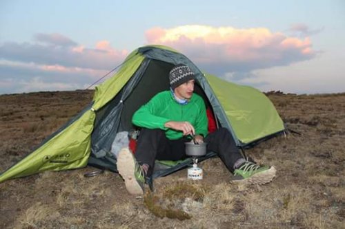
The tent we used was the 360 degree cool mountain extreme II and I was very impressed.
Well...until next time. .
Early in the wet misty morning of 9 October my fiance and I headed out from the Vergelegen camp site with a week's worth of food, a sound route in mind and optimism for good weather in our hearts.
Well, we only used half the food, the route fell to pieces and our optimism didn't pay off
On day 1 we headed up the Mkhomazi river to Birds Nest cave. It was a pleasant walk and we had a few glimpses of reassuring blue sky through the otherwise impenetrable grey blanket that hid most of the little berg from site. We lost the path in the indigenous forest about 500m from the cave and it took us an hour to cover that distance. The cave itself was fine and kept us dry through a wet and thunderous night.
The plan for day 2 was to take the path along the ridge NW of the cave towards Mkhomazi pass. At the base of the pass we were to follow the contour path East to the Evranda Rock Arch. The day started out well although there was low cloud and intermittent drizzle. We couldn't find the point where the path crossed the river but we knew it ran along the top of the ridge so decided to look for it there. It was a bit of a climb for us (450m)but by the time we reached the ridge the clouds had lifted and we had some beautiful views of King Kong and the Saddle. We soon picked up a vague path and followed it for a few hundred meters until it petered out into nothing. I know this happens a lot in the berg so I was confident we'd pick it up again later if we stuck to the same contour along the ridge. I was wrong. We did come across patches of path but nothing that we could follow for more than a few minutes. Looking north over the Mkhomazi valley I spotted a prominent rock arch on the eastern ridge of the saddle. It matched the position of the Evranda rock arch on the map, that was where we were headed and we clearly had a long way to go. A little later though we noticed another arch, this one directly below the saddle and MASSIVE! Confusion set in and, rather than consult the map again, we assumed that we'd been mistaken, misread the map and that this new arch was our planned destination. We decided to cross the Mkhomazi at the confluence with the stream that runs from the gully between King Kong and Nhlangeni Peak. From there it was a steep, wet, ankle twisting traverse to the arch which turned out to be very impressive. By the time we arrived though the wind had picked up, the rain was pelting down and all we wanted to do was climb into the tent. It was a hairy night on a pretty exposed campsite with lightening striking the high peaks around us and the wind putting our brand new tent to the test (it passed). At 2600m we were directly below the imposing cliffs of the Saddle; neither of us slept much that night.
On day 3 we were heading to Mlahlangubo pass. It was due to be a shortish day so we had a later start and after half an hour of more ankle twisting we spotted a path in the distance
It wasn't the best path in the world but it made the going just that much easier. The sun came out, the wind dropped and all was fine and dandy After a a couple of hours at a steady pace and still no sign of the pass we started having doubts about our position. Some dark clouds were also moving into the little berg valleys below us. Eventually though we did find an obvious and easy enough looking pass which we assumed to be Mlahlangubo. The wind had now picked up, the clouds were climbing towards us and Ali was experiencing a lot of pain in one ankle. If we headed up the pass we'd have 3 more nights in potentially deteriorating weather. If we headed East down the ridge we could overnight in runaway cave and be back in camp the next day. We chose the latter option. It wasn't long though before we realised that we might be on the wrong ridge but the presence of a path, a decent path, reassured us. The path, once again, didn't last long and we were soon trudging through heavy rain and thick mist, crisscrossing the river at every hint of a trail. Eventually though, at 18:00 the light was fading and we called it a day. Finally out of the rain, we minutely examined the map and eventually found our position. We were in the Mlahlangubo Omcane valley, not the Mlahlangubo omkhulu as we had thought. That meant we had never reached Mlahlangubo pass and the one we had seen must have been Ngaqamadola. This then meant that the Evranda rock arch on the map must refer to the small insignificant arch on the ridge from the Saddle and the large impressive arch where we spent the night did not feature on the map at all. Odd and frustrating. At least we now knew where we were and didn't have far to go the next day.By day 4 the weather hadn't improved and we had clearly made the right choice. It was only a couple of hours and we were back at the Vergelegen office. I had a look at the old map in the office (mine is a 2nd edition EKZNW map). The older map indicates one Evranda Rock BRIDGE where we spent the night and a minor rock arch on the ridge from the saddle. It all then fell into place.
Just for general info then - the coordinates for the Evranda Rock Bridge are 29°28'19.81"S 29°21'3.73"E
The tent we used was the 360 degree cool mountain extreme II and I was very impressed.
Well...until next time. .
Please login or register to view the images attached to this post.
The following user(s) said Thank You: intrepid, diverian, Hermann, plouw, Selous, Bigsnake, ghaznavid, brio, andrew r
Please Log in or Create an account to join the conversation.
- mikedexter
-
Topic Author
- Offline
- New Member
-
Less
More
- Posts: 9
- Thank you received: 9
23 Oct 2012 14:10 #55498
by Stijn
Replied by Stijn on topic Vergelegen hikes - 4 days or longer
Sounds like an adventure of note! In my experience, the paths in the Southern Berg are a very hit-and-miss affair, with cross-country navigation being the name of the game.
Great photos, btw - thanks for sharing.
Great photos, btw - thanks for sharing.
Please Log in or Create an account to join the conversation.

23 Oct 2012 15:46 - 23 Oct 2012 15:47 #55502
by ghaznavid
Replied by ghaznavid on topic Vergelegen hikes - 4 days or longer
Nice writeup
Sometimes thats the way hikes go, after failing to climb Popple 3 times last year (and finally getting it right in April this year - and it was well worth the 3 failed attempts), I can identify with the feeling. But as long as you enjoyed it and learned a bit more about our beloved not-a-pet Dragon, I'm sure it was well worth it")
Thats the same tent that I have - it is a really good tent, the only tent that I have never had issues with moisture buildup inside the next morning.
That looks really cool
Sometimes thats the way hikes go, after failing to climb Popple 3 times last year (and finally getting it right in April this year - and it was well worth the 3 failed attempts), I can identify with the feeling. But as long as you enjoyed it and learned a bit more about our beloved not-a-pet Dragon, I'm sure it was well worth it
mikedexter wrote: The tent we used was the 360 degree cool mountain extreme II and I was very impressed.
Thats the same tent that I have - it is a really good tent, the only tent that I have never had issues with moisture buildup inside the next morning.
mikedexter wrote: snestcave.jpg
That looks really cool
Last edit: 23 Oct 2012 15:47 by ghaznavid.
Please Log in or Create an account to join the conversation.

24 Oct 2012 21:43 #55522
by Serious tribe
Replied by Serious tribe on topic Vergelegen hikes - 4 days or longer
Thanks for the write up. I have not hiked in this area much, the only trip I have done here was a direct up and down Mkhomazi Pass to get to Thabana Ntleyana.
The Slingsby maps show a lot of the paths in that area as triple dots, a space and then another set of triple dots which means 'ill-defined' paths, so hence I am not surprised that you came unstuck on the route finding. Just to clarify, the rock arch image that you have in your report, is this the Evranda Rock Bridge or the smaller rock arch?
The Slingsby maps show a lot of the paths in that area as triple dots, a space and then another set of triple dots which means 'ill-defined' paths, so hence I am not surprised that you came unstuck on the route finding. Just to clarify, the rock arch image that you have in your report, is this the Evranda Rock Bridge or the smaller rock arch?
Please Log in or Create an account to join the conversation.
- Serious tribe
-

- Offline
- Platinum Member
-

Less
More
- Posts: 1057
- Thank you received: 778
25 Oct 2012 08:15 #55527
by mikedexter
Replied by mikedexter on topic Vergelegen hikes - 4 days or longer
It's the Evranda Rock Bridge. From the base of the arch to the top is around 30m so it's quite a feature and there's a very convenient ledge on the right of the image which makes for a great campsite although it doesn't receive much sunshine so probably not ideal in winter. .
Please Log in or Create an account to join the conversation.
- mikedexter
-
Topic Author
- Offline
- New Member
-
Less
More
- Posts: 9
- Thank you received: 9
08 Nov 2012 05:07 #55585
by intrepid
Take nothing but litter, leave nothing but a cleaner Drakensberg.
Replied by intrepid on topic Vergelegen hikes - 4 days or longer
Thanks for the write-up mikedexter, too bad it didn't work out according to plan. I see Vergelegen continues to live up to it's name
From various comments that I have heard it does seem like the Evandra Rock Arch is wrongly positioned on the map.
From various comments that I have heard it does seem like the Evandra Rock Arch is wrongly positioned on the map.
Take nothing but litter, leave nothing but a cleaner Drakensberg.
Please Log in or Create an account to join the conversation.
14 Sep 2015 17:25 #65083
by hartmrol
Replied by hartmrol on topic Vergelegen hikes - 4 days or longer
Hi all -
We are setting off on our annual berg hike next week. We plan to leave cars at Vergelegen campsite, ascend via Mlahlangubo pass, hike South along the escarpment towards Sani Pass and probably descend via Nhlangeni Pass.
Does anyone have any advice on the proposed route (better passes to descend?) and on places to find water en route.
We have never to been to this part of the berg, so any help would be welcome.
Regards
Rolf
Please Log in or Create an account to join the conversation.

14 Sep 2015 22:13 #65088
by Dillon
Replied by Dillon on topic Vergelegen hikes - 4 days or longer
I've only hiked there on one occasion; we did a 4 day round trip in June 2008. Planning to head back there maybe next year some time, my impression was that it's a fairly remote part of the 'Berg.
On our trip, we headed straight up the ridge from the KZN Wildlife office to the contour path below Ntsupenyana. We camped there for the night and then ascended Ngaqamadola South Pass, walked behind the Saddle and over the ridge, before making camp for the second night at the top of Mkhomazi Pass. Day 3 we descended the pass and headed for Bird's Nest Cave for the night, day 4 returned the office.
It was a fairly relaxed hike, water was rather scarce on the escarpment and along the ridge on Day 1, but we survived (it was the middle of winter). Both of the passes we did were dead easy, by berg standards.
We only had paths for the first 2km of day 1, a bit of a path near the top of Ngaqamadola Pass, probably about 1 or 2km on Mkhomazi Pass and then all of day 4. The rest of the time the path didn't really exist. This was back in 2008, conditions may have changed, but I'm not sure if they've gotten better or worse!
Hope this helps. Possibly if your group is feeling a bit tired and you don't feel like pushing on to Nhlangeni Pass, at least you know you have an easy bail out option down Mkhomazi Pass...
The following user(s) said Thank You: hartmrol
Please Log in or Create an account to join the conversation.