
Didima Pass
26 Aug 2018 21:14 - 27 Aug 2018 15:24 #73868
by tonymarshall
Didima Pass was created by tonymarshall
Didima Pass (or Ndedema Pass as it was spelt then) is mentioned in at least two of the Drakensberg books from the 1970’s (Doyle P Liebenberg :
The Drakensberg of Natal 1972 pg 157, and David A Dodds : A Cradle of Rivers 1975 pg 40). I have read both of these books several times, and paged through them many times in search of information, so I must have been aware of Ndedema Pass for a long time, but it never stood out or stuck in my memory.
Didima Pass is absent on the Drakensberg maps, all three mapseries that I use do not show it – Surveyor General maps, Slingsby’s maps, and
the current Geomaps. Surprisingly though, the pass is shown (but is not named) on the Garmin maps, which are based on the original Surveyor General maps, and were the first topographic maps of this area available for gps. Sometime after getting my gps and gps topo map, probably in 2012, I noticed this unnamed pass on the Garmin map, topping out on the escarpment between Didima Dome and Didima Buttress, about 1 ½ km south of Tlanyaku Pass (Hlanyaku Pass on the Garmin map), and it wasn’t difficult to conclude that this unnamed pass was Didima Pass.
Since then I have stood at the top of Didima Pass 5 times, looking down it, and wondering ‘does this go?’ The photo below, from June 2013, shows the top of Didima Pass atthe centre of the photo looking south from the slopes of Didima Dome with Didima Buttress in the background.
The photo below is a view down the pass, also from June 2013, with the Witch in the background at the left.
The photo below, from December 2016, shows the bottom section of the pass, joining the main gully, with the view down the Upper Didima Valley
and Schoongezicht Cave in the background.
The difficulty was that although it was visible that the top and bottom sections of the pass were doable, could they be joined, or were there
cliffs blocking the route in the middle area? The books didn’t say if Ndedema Pass was a hiking or climbing pass. Ghaznavid has spoken to an older MCSA member who did Didima Passin the 1960’s or 1970’s, and his information, although sketchy (to the effect that “there is a scramble or scrambles similar to Corner Pass”), encouraged us that this pass is doable. The discussion also gave the impression that Didima Pass was frequently used in that era, and it is strange that it has literally gone off the map. And so a year or so ago we determined with a few others that
we would have a go at Didima Pass.
On the August long weekend ghaznavid, Lorinda and I (many others withdrew from the trip) did our attempt on Didima Pass. In the days before the
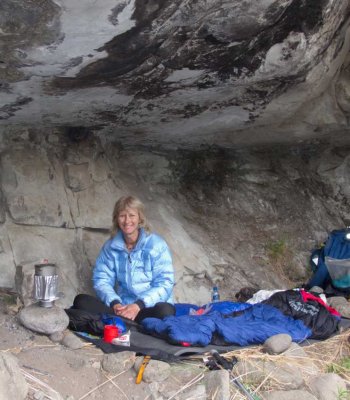
hike, the weather forecast showed an increase in snow for the Wednesday and Thursday nights, which was quite unusual, and when I last looked at the forecast on Wednesday around 30 cm snow was forecast for the escarpment. So not only would we be doing an unmarked pass, but we would have a snow adventure as well. On the Thursday we left Didima office taking the shortcut to Mike’s Pass road, and then the old shortcut from the first hairpin bend to near the weather station. It was cold, cloudy and misty and we couldn’t see to the escarpment. After a short lunch stop, we followed the old forestry track to the Nek, and between the swirling clouds we could see that there was not much snow on the distant escarpment. After descending Phillip’s Folly, we headed upstream settling in for the night in Schoongezicht Cave, just before the predicted evening rain
arrived.
It rained during the night, although we couldn’t hear the rain above the noise of the nearby river, in the morning the river level had risen
considerably and the grass was wet. We could also see to the escarpment, and there was quite a lot of snow around. Following the path to the base of Tlanyaku Pass, we made good progress, but later slowed considerably following the course of the Didima River in the rain, traversing rugged and bushy terrain. The photo below shows the river bed just after we started following the river.
It had been raining on and off, but the weather cleared and we had a view to the escarpment ahead. The river had narrowed, and we alternated
between boulder hopping in the river and the bush on the side. The photo below shows the view ahead to Didima Buttress at the centre of the photo, we would basically follow the river to close to the base of Didima Buttress and make a sharp 90 degree right turn to go up the pass.
Another view upstream, again with Didima Buttress dominating the skyline. In the approach to Didima Pass we saw evidence of litter from smugglers and locals (matchboxes and threads of bags), and from hikers (a pink water bottle lid), so this area does get some traffic. There was also hikers litter (energy bar wrappers) in the pass itself.
We had lunch at the base of Didima Pass, which was ironically marked by a pine tree in the valley.
The Drakensberg of Natal 1972 pg 157, and David A Dodds : A Cradle of Rivers 1975 pg 40). I have read both of these books several times, and paged through them many times in search of information, so I must have been aware of Ndedema Pass for a long time, but it never stood out or stuck in my memory.
Didima Pass is absent on the Drakensberg maps, all three mapseries that I use do not show it – Surveyor General maps, Slingsby’s maps, and
the current Geomaps. Surprisingly though, the pass is shown (but is not named) on the Garmin maps, which are based on the original Surveyor General maps, and were the first topographic maps of this area available for gps. Sometime after getting my gps and gps topo map, probably in 2012, I noticed this unnamed pass on the Garmin map, topping out on the escarpment between Didima Dome and Didima Buttress, about 1 ½ km south of Tlanyaku Pass (Hlanyaku Pass on the Garmin map), and it wasn’t difficult to conclude that this unnamed pass was Didima Pass.
Since then I have stood at the top of Didima Pass 5 times, looking down it, and wondering ‘does this go?’ The photo below, from June 2013, shows the top of Didima Pass atthe centre of the photo looking south from the slopes of Didima Dome with Didima Buttress in the background.
The photo below is a view down the pass, also from June 2013, with the Witch in the background at the left.
The photo below, from December 2016, shows the bottom section of the pass, joining the main gully, with the view down the Upper Didima Valley
and Schoongezicht Cave in the background.
The difficulty was that although it was visible that the top and bottom sections of the pass were doable, could they be joined, or were there
cliffs blocking the route in the middle area? The books didn’t say if Ndedema Pass was a hiking or climbing pass. Ghaznavid has spoken to an older MCSA member who did Didima Passin the 1960’s or 1970’s, and his information, although sketchy (to the effect that “there is a scramble or scrambles similar to Corner Pass”), encouraged us that this pass is doable. The discussion also gave the impression that Didima Pass was frequently used in that era, and it is strange that it has literally gone off the map. And so a year or so ago we determined with a few others that
we would have a go at Didima Pass.
On the August long weekend ghaznavid, Lorinda and I (many others withdrew from the trip) did our attempt on Didima Pass. In the days before the
hike, the weather forecast showed an increase in snow for the Wednesday and Thursday nights, which was quite unusual, and when I last looked at the forecast on Wednesday around 30 cm snow was forecast for the escarpment. So not only would we be doing an unmarked pass, but we would have a snow adventure as well. On the Thursday we left Didima office taking the shortcut to Mike’s Pass road, and then the old shortcut from the first hairpin bend to near the weather station. It was cold, cloudy and misty and we couldn’t see to the escarpment. After a short lunch stop, we followed the old forestry track to the Nek, and between the swirling clouds we could see that there was not much snow on the distant escarpment. After descending Phillip’s Folly, we headed upstream settling in for the night in Schoongezicht Cave, just before the predicted evening rain
arrived.
It rained during the night, although we couldn’t hear the rain above the noise of the nearby river, in the morning the river level had risen
considerably and the grass was wet. We could also see to the escarpment, and there was quite a lot of snow around. Following the path to the base of Tlanyaku Pass, we made good progress, but later slowed considerably following the course of the Didima River in the rain, traversing rugged and bushy terrain. The photo below shows the river bed just after we started following the river.
It had been raining on and off, but the weather cleared and we had a view to the escarpment ahead. The river had narrowed, and we alternated
between boulder hopping in the river and the bush on the side. The photo below shows the view ahead to Didima Buttress at the centre of the photo, we would basically follow the river to close to the base of Didima Buttress and make a sharp 90 degree right turn to go up the pass.
Another view upstream, again with Didima Buttress dominating the skyline. In the approach to Didima Pass we saw evidence of litter from smugglers and locals (matchboxes and threads of bags), and from hikers (a pink water bottle lid), so this area does get some traffic. There was also hikers litter (energy bar wrappers) in the pass itself.
We had lunch at the base of Didima Pass, which was ironically marked by a pine tree in the valley.
Please login or register to view the images attached to this post.
Last edit: 27 Aug 2018 15:24 by tonymarshall.
Please Log in or Create an account to join the conversation.
- tonymarshall
-
 Topic Author
- Offline
- VE Advisory
-

Less
More
- Posts: 768
- Thank you received: 2233
26 Aug 2018 21:21 - 27 Aug 2018 15:28 #73869
by tonymarshall
Replied by tonymarshall on topic Didima Pass
Our first view up the pass itself. It was apparent that it was a steep pass and we could see lots of scrambling ahead, precisely what we had
expected.
A view back down the lower part of the pass, back to the marker pine tree.
Bypassing a waterfall.
A view up Didima Pass, showing the steep terrain and waterfalls. Just before the spires, near the top of this gully, we would traverse left (true right) into another gully which would take us to the top of the pass.
We had a spectacular view to the escarpment opposite the pass, and the gully opposite in shadow looks doable, although with a lot of scrambling. We could also identify the prominent arête as the same one visible when looking down the pass from the top.
The pass narrowed further, and we had to climb up some of the waterfalls. There was a surprising amount of water in the stream for this time
of year, presumably from the recent rain and melting snow, and it was apparent that this pass would not be doable with a lot of water in the stream.
ghaznavid near the top of one of the waterfall scrambles.
Bypassing another waterfall on the adjacent grass slope. By now we had lost count of the waterfalls we had bypassed or scrambled up, but there
were eight to ten. We had also reached the snowline, and it suddenly got really cold as we moved into the snow from the warmer lower half of the pass.
Please login or register to view the images attached to this post.
Last edit: 27 Aug 2018 15:28 by tonymarshall.
Please Log in or Create an account to join the conversation.
- tonymarshall
-
Topic Author
- Offline
- VE Advisory
-
Less
More
- Posts: 768
- Thank you received: 2233
26 Aug 2018 21:28 - 27 Aug 2018 15:34 #73870
by tonymarshall
Replied by tonymarshall on topic Didima Pass
A view back down the pass from the snow.
We traversed left into the adjacent gully, and the photo below shows the view down this gully.
The top of the pass was finally within sight, and we ascended in 20 – 30 cm of snow.
It was windy and cold at the top of Didima Pass, and we didn’t linger long in tackling the final 4 km of the day to Didima Cave, our overnight
spot. As we ascended Didima Buttress, we had this view back to the top of Didima Pass, the dark gash at the centre of the photo below, with Didima Dome behind the pass on the right.
Fortunately the snow was quite solid, and the walking to Didima Cave wasn’t too difficult, although as it is, we got there after dark, and enjoyed the relief of taking off our frozen boots. We changed plans overnight, deciding to descend Tlanyaku Pass, and avoid the long trek through the summit
snow to the unmarked pass we had planned to descend. On Saturday morning we had a late start, putting our boots and shoes in the sun to thaw out, particularly ghaz’s trail shoes were frozen solid. Then we retraced the previous evenings’ route back through the snow to the top of Didima Pass, where we had this view down the pass with the Witch in the background.
We took our Didima Pass summit photo, all wearing sunglasses for the glare off the snow, although even in the sun it was cold.
That afternoon, we descended Tlanyaku Pass, and had this view down into the approach to Didima Pass which we had done the previous day. In
the photo below the approach to Didima Pass can be seen as the valley, with Didima Buttress the peak to the right of the centre of the photo. Didima Pass follows the gully behind the foreground ridge line to top out at the right of Didima Buttress.
I’ve included the map of our track below, which shows the approach south along the valley from where we left the Tlanyaku Pass route, and then the pass ascent westwards. On the return route, ghaznavid and I ascended Didima Dome, with some awesome views, before we descended the slopes of Didima Dome, and then Tlanyaku Pass, back to Schoongezicht Cave.
Didima Pass was an interesting and tough route. Ghaz and I both consider it to be harder than Xeni Pass, with a much tougher approach, and harder pass with a lot more scrambling.
There are more photos of Didima Pass in ghaznavid’s write up of the hike in the ‘Mini hike reports’ thread.
Please login or register to view the images attached to this post.
Last edit: 27 Aug 2018 15:34 by tonymarshall.
The following user(s) said Thank You: Serious tribe, diverian, elinda, Stijn, JonWells, SeriousTribe2, ghaznavid, Smurfatefrog, pfoj, AndrewP, Riaang, Andreas, TheRealDave, Christinejvr, GriffBaker, ALPAT
Please Log in or Create an account to join the conversation.
- tonymarshall
-
Topic Author
- Offline
- VE Advisory
-
Less
More
- Posts: 768
- Thank you received: 2233
28 Aug 2018 14:40 #73897
by Sabine
Replied by Sabine on topic Didima Pass
Wow what a pass! Thanks for opening up another route, one I will definitely be trying out in the near future.
Please Log in or Create an account to join the conversation.
31 Aug 2018 11:45 #73913
by Riaang
Replied by Riaang on topic Didima Pass
Thanks for the write-up Tony, sounds like an awesome pass, definitely one on the to-do list
Please Log in or Create an account to join the conversation.

06 Nov 2025 11:27 #80052
by hikingviking
Replied by hikingviking on topic Didima Pass
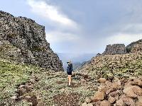
This past weekend, a group of us explored several passes in the Cathedral Peak area: Didima, Tlanyaku, Xeni North, and Mlambonja.
Here is a brief writeup about Didima Pass, along with some photos.
The hike in is absolutaly stunning.
You boulder-hop up the river for a while before entering Didima pass. It looks overgrown, but it’s actually quite pleasant.
There are a few obstacles that you need to manoeuvre, either climbing up steep grassy slopes to get around, or climb up them.
The views looking back are breathtaking!
Another obstacle, this time we could climb up it.
We went too far up the gully and ended up hitting an obstacle that wasn't passable (for our skill level). The obstacle is in the shadow part of the picture, quite a big boulder blocking you from going up. We tried heading up the sides, but it didn't feel safe, so we headed back down to find another way up.
We missed the very obvious grass slope (chatting too much) at about 2750m that you have to take all the way up to the top of the pass. See below for where we went wrong, where we headed back down and then went up the correct way on the very steep grassy slopes.
Further up the pass we had a 20m stretch of these beautiful pink flowers, almost like they only grow on this elevation, really amazing to see! If anyone knows what they are called, please let us know!
This pass is really spectacular and so much fun. I would highly recommend it to anyone that wants a bit of a challenge and want to see a part of the mountains that not a lot of people get to experience.
We headed down Tlanyaku pass with some epic views of DIdima Falls. The one girl, Mix, almost stepped on a Rinkhals on the final part of the ridge heading down, and a few minutes later we saw a huge mole snake (if our ID was correct).
Full route on Strava: www.strava.com/activities/16322555452
Please login or register to view the images attached to this post.
The following user(s) said Thank You: elinda, Stijn, JonWells, DeonS, firephish, ghaznavid, MarkT, Smurfatefrog, tonymarshall, AndrewP, supertramp, Riaang, riaan300, andrehayward, ALPAT
Please Log in or Create an account to join the conversation.
- hikingviking
-

- Offline
- Junior Member
-

Less
More
- Posts: 17
- Thank you received: 100
06 Nov 2025 15:57 - 06 Nov 2025 16:06 #80056
by Serious tribe
Replied by Serious tribe on topic Didima Pass
@hv. These look like Nerine appendiculata. Looks like a great trip. When Tony M went up there in 2018 there was a pine tree at the one junction, did you see it there at all?
Last edit: 06 Nov 2025 16:06 by Serious tribe.
Please Log in or Create an account to join the conversation.
- Serious tribe
-

- Offline
- Platinum Member
-

Less
More
- Posts: 1055
- Thank you received: 770
06 Nov 2025 19:09 #80061
by hikingviking
Replied by hikingviking on topic Didima Pass
Thanks for the flower ID, it's such great knowledge to know the flowers, trees and plants in the mountains, something our group are still working on!
Happy to report that the pine tree is still standing.
Happy to report that the pine tree is still standing.
The following user(s) said Thank You: Serious tribe
Please Log in or Create an account to join the conversation.
- hikingviking
-
- Offline
- Junior Member
-
Less
More
- Posts: 17
- Thank you received: 100
06 Nov 2025 21:39 #80062
by Smurfatefrog
Replied by Smurfatefrog on topic Didima Pass
Please go back with your bowsaw and cut it down, thanksThanks for the flower ID, it's such great knowledge to know the flowers, trees and plants in the mountains, something our group are still working on!
Happy to report that the pine tree is still standing.
The following user(s) said Thank You: Carl Gebhard
Please Log in or Create an account to join the conversation.
- Smurfatefrog
-

- Offline
- Moderator
-
Less
More
- Posts: 1129
- Thank you received: 1541
10 Nov 2025 01:56 #80071
by Michelle_Gordon
Replied by Michelle_Gordon on topic Didima Pass
Please go back with your bowsaw and cut it down, thanks. Snurf: I marked a few pines for the Busters. There's work to be done.Thanks for the flower ID, it's such great knowledge to know the flowers, trees and plants in the mountains, something our group are still working on!
Happy to report that the pine tree is still standing.
Please Log in or Create an account to join the conversation.
- Michelle_Gordon
-
- Offline
- New Member
-

Less
More
- Posts: 2
- Thank you received: 0
