Elandshoek Pass
14 Aug 2022 00:06 - 14 Aug 2022 00:14 #77942
by supertramp
Replied by supertramp on topic Elandshoek Pass
Elandshoek 3/3
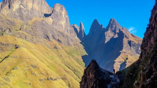
Looking back to the pass entrance, just before turning around the corner. The pass drops down just before the snow line
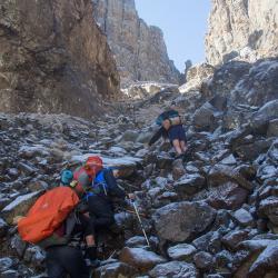
One more thing to mention on the contour path heading towards the pass proper: There is a junction, as per image below, with a deceptive path heading down and to the south east. The correct path to take is the upper one.
Final thoughts: Elandshoek is definitely amongst my top 5 passes in the Berg, it is truly unique. I would not rate it as a beginners pass and would say that a fair amount of Berg experience is recommended before attempting it. It is WELL worth the effort though and is highly recommended for anyone that has it on their to-do-list. It took us about 5 hours (with full packs) to ascend from the contour path on northern side of the shortcut, but included 2 half hour breaks. I note that on this thread, mention is made that it is a smugglers pass, but I must admit that we've not really seen clear signs of recent use the previous 3 times (in the form of litter, animal dung, carcasses etc.) (Judges pass is however a different kettle of fish altogether, as it looked like a rubbish dump out there, very sad). The usual precautions regarding location of camp, amongst others, in that vicinity is still recommended.
Please login or register to view the images attached to this post.
Last edit: 14 Aug 2022 00:14 by supertramp.
The following user(s) said Thank You: Stijn, JonWells, DeonS, firephish, Smurfatefrog, tonymarshall, ASL-Bivak#, TheRealDave, GriffBaker, Carl Gebhard, Walkfree
Please Log in or Create an account to join the conversation.
- supertramp
-

- Offline
- Elite Member
-

Less
More
- Posts: 211
- Thank you received: 450
26 Apr 2024 08:53 #79056
by Carl Gebhard
Replied by Carl Gebhard on topic Elandshoek Pass
Giving this a bash late May.
Coming from Giant's via Oribi and Gable Shortcut.
As far as I can tell between the Gable and the Pass there's no real camping spots, for three tents, is this correct?
So best to kip NE of that Ka-Mbevula / Sisters Ridge in my estimation.
Regards
CG
Coming from Giant's via Oribi and Gable Shortcut.
As far as I can tell between the Gable and the Pass there's no real camping spots, for three tents, is this correct?
So best to kip NE of that Ka-Mbevula / Sisters Ridge in my estimation.
Regards
CG
Please Log in or Create an account to join the conversation.
- Carl Gebhard
-

- Offline
- Premium Member
-

Less
More
- Posts: 113
- Thank you received: 64
26 Apr 2024 12:12 #79058
by Riaang
Replied by Riaang on topic Elandshoek Pass
Carl,
We've pitched 2 tents about 100m or so from the top of Elandshoek pass, just to the right of the path. It wasn't the most level spot - lots of tufts of grass but we managed to fill up the gaps with grass a bit. It was relatively flat though, so ok-ish. It was the highest spot in the entire area (that was relatively level) and it was raining cats and dogs that entire evening and our tent didn't get flooded. Not sure if this would help you find it though, but at least it is some extra info
Nowhere near water though, so you will need to fill up before you get to this spot. Also, from what I remember there was no water on Elandshoek pass. We went up it and filled up at a nice stream just a few hundred meters from where the contour path splits towards Giants hut. So, a few hundred meters towards Elandshoek pass if you were coming up from Giants camp and then turned left towards Elandshoek pass. The situation might be different now with all the rain we've had lately, but just be aware that water might only be found lower down the pass.
Interesting pass, this one. We only managed to do it on our 4th attempt (mist, rain, then snow, then nice weather) and it was quite a tricky little pass in my opinion. After topping out all 3 of us agreed that you have to concentrate a bit on this pass. The path was narrow, twisty, boulder strewn and uneven, making forward progress quite slow and hard work (harder than normal for me). Easy to stumble if you were not focussing with relatively steep, althoug be it shallow drop-offs on your (right-hand) side as you come down, so just take note of this Carl.
Other than this it was a beuatiful pass and we enjoyed it.
If you don't want to walk all around the ridge as you come down the pass, you can hop over between those 2 bumps neare towards the end of the ridge. There is a big vertical gash coming down from near the top of the ridge right to near the footpath. Just stick to the left of this gash and go up and over the ridge. You will find a path from the top down towards the contour path on the other side. I wrote a trip report about our Elandshoek hike, check it out and you will see images of the shortcut on both sides of the ridge.
Enjoy!!!
The following user(s) said Thank You: Carl Gebhard
Please Log in or Create an account to join the conversation.
02 May 2024 10:51 #79072
by supertramp
Just did an ascent of Elandshoek again over the weekend. I sent you an email with 3 plausible camp spots.
As Riaang mentioned, with the recent rains water is abundant in all the side streams on the contour path towards Elands Gully, I believe most of them will still be good until your planned trip at the end of the month. In the odd chance that it has dried up, the crossing-point at Elands Gully has been good on my previous 4 trips (winter and summer).
Enjoy your hike!!! Elandshoek is an absolute jewel
Replied by supertramp on topic Elandshoek Pass
Hi Carl,Giving this a bash late May.
Coming from Giant's via Oribi and Gable Shortcut.
As far as I can tell between the Gable and the Pass there's no real camping spots, for three tents, is this correct?
So best to kip NE of that Ka-Mbevula / Sisters Ridge in my estimation.
Regards
CG
Just did an ascent of Elandshoek again over the weekend. I sent you an email with 3 plausible camp spots.
As Riaang mentioned, with the recent rains water is abundant in all the side streams on the contour path towards Elands Gully, I believe most of them will still be good until your planned trip at the end of the month. In the odd chance that it has dried up, the crossing-point at Elands Gully has been good on my previous 4 trips (winter and summer).
Enjoy your hike!!! Elandshoek is an absolute jewel
This image is hidden for guests.
The following user(s) said Thank You: Carl Gebhard
Please Log in or Create an account to join the conversation.
- supertramp
-

- Offline
- Elite Member
-

Less
More
- Posts: 211
- Thank you received: 450


