
Gypaetus Pass
03 Oct 2016 12:45 #69936
by Smurfatefrog
")
Replied by Smurfatefrog on topic Gypaetus Pass
I think if you did Tseke along the actual path you'd find it quite easy. Langies would also seem tough if you tried to go directly down the gullyghaznavid wrote: I would say harder than Mashai Pass, easier than Tseketseke.
Please Log in or Create an account to join the conversation.
- Smurfatefrog
-

- Offline
- Moderator
-

Less
More
- Posts: 1134
- Thank you received: 1551
03 Oct 2016 22:16 #69942
by ghaznavid

Replied by ghaznavid on topic Gypaetus Pass
Mayhaps. After you do Gypaetus Pass you can do the necessary comparisonSmurfatefrog wrote: I think if you did Tseke along the actual path you'd find it quite easy
Please Log in or Create an account to join the conversation.

10 Apr 2024 21:52 - 10 Apr 2024 21:56 #79011
by supertramp
Replied by supertramp on topic Re: Gypaetus Pass
Hi. My wife and I are planning an ambitious trip to Giants Castle area at the end of April. The idea is to attempt doing 6 passes over 5 days. We've done quite a few 4 pass trips before and in the spirit of adventure, we want to continue testing our hiking limits
The current plan is as follows.
Day 1 Giants Castle camp - Oribi Ridge - One day summit of Elandshoek pass (using Gable shortcut)
Day 2 Descend South Jarateng (the only one of the 3 we haven't done yet) and ascend Bonds pass
Day 3 Descend South Hlubi and ascend Thumb Pass (both of these passes will be new to us, even though we've scouted them on previous visits)
Day 4 Descend Gypaetus Pass
Day 5 Back to the start
My question relates to Gypaetus pass. Has anyone perhaps descended the pass before? Or even if you've only ascended it, any advice you won't mind sharing for a planned descent? From previous write-ups I can deduce that is quite steep and has a few tricky sections over the last few hundred meters. Any tips will be greatly appreciated.
This image is hidden for guests.
This image is hidden for guests.
The current plan is as follows.
Day 1 Giants Castle camp - Oribi Ridge - One day summit of Elandshoek pass (using Gable shortcut)
Day 2 Descend South Jarateng (the only one of the 3 we haven't done yet) and ascend Bonds pass
Day 3 Descend South Hlubi and ascend Thumb Pass (both of these passes will be new to us, even though we've scouted them on previous visits)
Day 4 Descend Gypaetus Pass
Day 5 Back to the start
My question relates to Gypaetus pass. Has anyone perhaps descended the pass before? Or even if you've only ascended it, any advice you won't mind sharing for a planned descent? From previous write-ups I can deduce that is quite steep and has a few tricky sections over the last few hundred meters. Any tips will be greatly appreciated.
Last edit: 10 Apr 2024 21:56 by supertramp.
Please Log in or Create an account to join the conversation.
- supertramp
-
- Offline
- Elite Member
-

Less
More
- Posts: 227
- Thank you received: 464
11 Apr 2024 08:07 #79012
by ghaznavid
Replied by ghaznavid on topic Re: Gypaetus Pass
Sounds like my type of traverse! I assume you are aware that there's a bit of a walk from the bottom of South Hlubi to Thumb Pass, they top out right near each other, but the bottom is something like 3km of contour path apart as they start on opposite sides of The Thumb. I've wondered about a line on the south side of Thumb, or if one follows the ridge instead of the gully - but I don't know anyone who has actually tried either option. Both times I did the pass, I used the gully on the north side of Thumb.
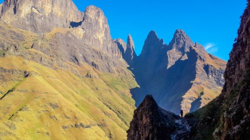
Re descending Gypaetus Pass: I've done it 3 times, but always up. I know AndrewP has come down it, though. Obviously a GPS track would help - the only factor for navigation is finding the traverse, which is easy on the way up as you go up the gully till you hit a cliff, and then turn left. If you get the line right, there are no tricky sections on the pass, it's entirely no grass, no scrambling. It isn't very steep, well, for a pass. If it had a trail it would probably be a difficulty 3 pass, similar difficulty to Bannerman.
The key to the traverse is finding the start and finish. This small waterfall will be the spot you are looking at to start traversing:
And this cliff is the point to mark the end of the traverse - or the other way around for ascending parties:
You'll need to find the gap in the cliff at the top of the pass and use that ledge to access the main grassy slope - although you can easily scramble down the top cliff if you don't find the ledge. You then aim away from Bannerman Pass gully towards the ridgeline, but stay a bit short of the ridgeline before the traverse to avoid cliffs. When you hit the small waterfall in the picture above (which is likely dry most of the year), follow the ledge around the corner till you see the main gully, which you can follow down to the contour path.
I am biased on this one, but I have always enjoyed this pass - it provides something different from the standard grass gullies that make up most of the Drakensberg pass list.
Please login or register to view the images attached to this post.
The following user(s) said Thank You: supertramp
Please Log in or Create an account to join the conversation.
11 Apr 2024 10:39 - 11 Apr 2024 10:45 #79013
by supertramp
Replied by supertramp on topic Re: Gypaetus Pass
Thanks a million for the great tips and photos ghaznavid, it is appreciated!
We will be ticking off quite a few firsts if all goes according to plan, just hoping that the weather plays along (we've got a few back-up options, just in case).
Yes, thanks, I am aware of the distance between South Hlubi and Thumb pass, it is quite the loop-around.
Regarding the GPS track - yes, that is always of great help. I've downloaded the one available on VE, see that it was uploaded on 2013. From studying it on Google Earth, am I correct in identifying the start of the traverse?
Please login or register to view the image attached to this post.
Last edit: 11 Apr 2024 10:45 by supertramp.
Please Log in or Create an account to join the conversation.
- supertramp
-
- Offline
- Elite Member
-
Less
More
- Posts: 227
- Thank you received: 464
11 Apr 2024 16:35 #79015
by ghaznavid
Replied by ghaznavid on topic Re: Gypaetus Pass
Yes, that's where you start traversing.
The following user(s) said Thank You: supertramp
Please Log in or Create an account to join the conversation.
11 Apr 2024 19:37 #79017
by AndrewP
Replied by AndrewP on topic Re: Gypaetus Pass
I did indeed descend Gypaetus Pass. One of those lets leave the escarpment about sunset moments and have to race down in the last bits of light.
I cannot remember too many details. I traversed to the ridge line rather high up and kept backtracking to descend one rock band and then back to ridge only to repeat.
I probably sneaked around the ridge line too high because I had one noticeable rock band to get through afterwards. this was the only section where I recall actually getting onto rock.
That though was one of my earlier tricky passes, so would probably do better if I tried it today.
It sounds like a fun trip. Enjoy
Please Log in or Create an account to join the conversation.
15 Apr 2024 14:01 #79027
by supertramp
Replied by supertramp on topic Re: Gypaetus Pass
Thank you for sharing AndrewP, much appreciated!!! Looking forward to the opportunity of giving it a go.
Please Log in or Create an account to join the conversation.
- supertramp
-
- Offline
- Elite Member
-
Less
More
- Posts: 227
- Thank you received: 464
