Ape Pass
19 Aug 2020 20:59 #75961
by tonymarshall
Replied by tonymarshall on topic Ape Pass
Hi Riaan,
It wasn't that difficult, I would say a bit easier than that crux obstacle on Mlambonja Buttress South Pass, but the difference is this was quite a bit higher, and a fall near the top could be nasty.
There is a way to bypass that obstacle, because AndrewP didn't mention it in his write up, so that is a way to avoid the obstacle, on the true right grass slope Andrew mentioned.
It was wet and slippery when we did it, so it wouldn't really be an issue if there was a bit of flowing water in summer, but if there is a lot of flowing water, it may become almost impossible, and to use the bypass grass slope would be essential.
Try and do it, it was an enjoyable pass, and you and yours are certainly up for a challenge.
Strangely as I'm getting older, I feel the cold a lot more than when I was younger, but I don't have any plans to stop wearing shorts in winter soon.")
It wasn't that difficult, I would say a bit easier than that crux obstacle on Mlambonja Buttress South Pass, but the difference is this was quite a bit higher, and a fall near the top could be nasty.
There is a way to bypass that obstacle, because AndrewP didn't mention it in his write up, so that is a way to avoid the obstacle, on the true right grass slope Andrew mentioned.
It was wet and slippery when we did it, so it wouldn't really be an issue if there was a bit of flowing water in summer, but if there is a lot of flowing water, it may become almost impossible, and to use the bypass grass slope would be essential.
Try and do it, it was an enjoyable pass, and you and yours are certainly up for a challenge.
Strangely as I'm getting older, I feel the cold a lot more than when I was younger, but I don't have any plans to stop wearing shorts in winter soon.
Please Log in or Create an account to join the conversation.
- tonymarshall
-

- Offline
- VE Advisory
-

Less
More
- Posts: 770
- Thank you received: 2244
02 Mar 2026 13:11 #80242
by hikingviking
Replied by hikingviking on topic Ape Pass
Over the weekend of the 21st of February, a small group of us explored several passes in the Injisuthi area: Corner, Around the Corner, Judge, Apes and Leslies.
The approach to the Leslies/Ape split was completely washed away from the floods, so from Marble Baths Cave to the split is just boulder hopping now (everything is very loose after the floods, so watch your footing). See below image for a photo of the riverbed, taken from near Marble Baths Cave.
From the Leslies/Ape split, the boulder hopping continues pretty much all the way to the waterfall obstacle where the pass starts to narrow. There were times were we had to stay on the river banks as the floods created lots of damage in the riverbed itself and it was safer to stay higher. It should be quite obvious once you are making your way up. See below image for a photo of us making our way up the pass.
Below photo shows us higher up in the pass, the boulders getting a bit bigger.
Some fun scrambling:
Eventually you would get to the waterfall obstacle where the pass narrows. There was a lot of water coming down so we had to back track to the alternative route that Andrew Porter used. The photo doesn't really show how high the waterfall is as I took it from a bad angle:
We tracked back to the side gully about 50m back, made our way up and moved to the ridge between the main gully and the side gully:
We got to the tricky rock band section that AndrewP mentioned. Rather than going over it, like AndrewP did, we made our way back into the side gully and moved up from there where it eventually evens out at the top. It felt more safer for us. The mist started moving in from here.
Some amazing views before making our way down to the main gully:
We attempted to descend this pass last year. There was also a crazy amount of water coming down so we had to use the steep grassy banks to get onto the alternative route (the mist was too thick so we ended up turning back). Our entry point was much different then, and I believe the floods might have had an impact on the pass as we had to get an alternative entry point back into the main gully this time around (at about 2770m). We got stuck in a tricky spot and decided to track back before finding another way down. We didn't see the cairn that AndrewP mentioned either. The orange line is the alternative line that AndrewP used (mapped by Tony) and the blue line was our route.
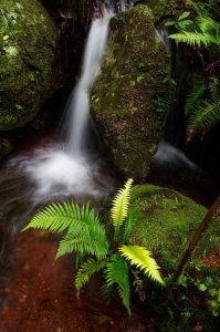
After getting back into the main gully, you will head up the gully for about 50-100m before you need to head up on the steep grassy banks on the other side of the gully. A photo from the top of the pass that I took last year:
It can be quite tricky to navigate the top section in the mist.
Full route on Strava: www.strava.com/activities/17487497713
The approach to the Leslies/Ape split was completely washed away from the floods, so from Marble Baths Cave to the split is just boulder hopping now (everything is very loose after the floods, so watch your footing). See below image for a photo of the riverbed, taken from near Marble Baths Cave.
From the Leslies/Ape split, the boulder hopping continues pretty much all the way to the waterfall obstacle where the pass starts to narrow. There were times were we had to stay on the river banks as the floods created lots of damage in the riverbed itself and it was safer to stay higher. It should be quite obvious once you are making your way up. See below image for a photo of us making our way up the pass.
Below photo shows us higher up in the pass, the boulders getting a bit bigger.
Some fun scrambling:
Eventually you would get to the waterfall obstacle where the pass narrows. There was a lot of water coming down so we had to back track to the alternative route that Andrew Porter used. The photo doesn't really show how high the waterfall is as I took it from a bad angle:
We tracked back to the side gully about 50m back, made our way up and moved to the ridge between the main gully and the side gully:
We got to the tricky rock band section that AndrewP mentioned. Rather than going over it, like AndrewP did, we made our way back into the side gully and moved up from there where it eventually evens out at the top. It felt more safer for us. The mist started moving in from here.
Some amazing views before making our way down to the main gully:
We attempted to descend this pass last year. There was also a crazy amount of water coming down so we had to use the steep grassy banks to get onto the alternative route (the mist was too thick so we ended up turning back). Our entry point was much different then, and I believe the floods might have had an impact on the pass as we had to get an alternative entry point back into the main gully this time around (at about 2770m). We got stuck in a tricky spot and decided to track back before finding another way down. We didn't see the cairn that AndrewP mentioned either. The orange line is the alternative line that AndrewP used (mapped by Tony) and the blue line was our route.
After getting back into the main gully, you will head up the gully for about 50-100m before you need to head up on the steep grassy banks on the other side of the gully. A photo from the top of the pass that I took last year:
It can be quite tricky to navigate the top section in the mist.
Full route on Strava: www.strava.com/activities/17487497713
Please login or register to view the images attached to this post.
The following user(s) said Thank You: Serious tribe, Stijn, JonWells, firephish, ghaznavid, PeterHowells, MarkT, Smurfatefrog, tonymarshall, Sabine, Riaang, riaan300, Smithers_23, Pathfinder, jeanweinmann
Please Log in or Create an account to join the conversation.
- hikingviking
-

- Offline
- Junior Member
-

Less
More
- Posts: 17
- Thank you received: 100
20 Mar 2026 13:34 #80264
by Mountain0live
Replied by Mountain0live on topic Ape Pass
It is all over the news, but I haven’t seen it here yet. Following the flooding at Marble baths, Injusuthi camp is closed until at least 1 May 2026.
Please Log in or Create an account to join the conversation.
- Mountain0live
-

- Offline
- New Member
-

Less
More
- Posts: 1
- Thank you received: 0