
- Forum
- Drakensberg Forum
- Drakensberg Trips
- AmaNgwane (Mnweni & other areas)
- Mnweni: The tale of two hikes
Mnweni: The tale of two hikes
Any way – Ian (ASL), Chris (ccjoubert), his brother and 2 friends as well as myself all signed up. I have said before that the only way to get stronger is to do what is substantially harder than your current ability. This hike – not by design – turned out to be one of those times for me.
So Stijn is of the opinion that getting a lift along the roads at Mnweni is cheating. So at 5AM we set off from the cultural centre. The weather was looking great, but we were in for a hot and humid day!
Before long we were at the Mnweni Pools – it was flooded and even walking over the bridge we were getting wet. After a very short break we continued to push on. At the Ifidi Pools we took another break – well more like Chris and his friends swam while I caught up with everyone else.
As I struggled across the Ifidi River it was becoming apparent to me that I had bitten off more than I could chew. It was only around 8AM, but this fast pace and no breaks approach was really taking its toll, the heat and humidity wasn’t helping.
I am of the opinion that being straight with the hike leader is the best approach – so I told Stijn that I was struggling, I still wanted to do Pins Pass, but I don’t want the entire group to miss the target because of me. About half an hour later as we passed 5 Star Cave he told me that Ian and I would head up Mnweni Pass while the others kept to the plan. We would meet up in Mponjwane Cave and if we weren’t there by 4 they would come and look for us. Bear in mind it was only around 10AM!
Equipped with a map, no GPS and neither of us having done Mnweni Pass we set off after a 20 minute break (and some rehydrate). The heat had clearly hit us both quite hard.
We slowly plodded along – the others no longer in sight. Not far thereafter we stopped for another break (and some more rehydrate). After a while I had a look up and realised that we had missed a turnoff somewhere – I was looking straight at Rwanqa Pass, Pins where above me and we were on the wrong side of the Pins ridge. After a long debate we agreed to turn around and soon found the correct path.
We started the long slog up toward the pass after crossing the river. We found a shady spot and stopped there for lunch. It was almost midday and neither of us were feeling well.
We completed the slog toward the pass and began ascending. Near the lower saddle we met up with a team that had spent a few nights in the mountain. We had a chat with them – the brief break was welcome.
As we continued to slog up the pass I continued to feel worse. I kept falling further and further back.
By two thirds of the way up the pass I had run out of water – that’s 4.5l for the day at that point, 2 rehydrate sachets and my mouth was completely dry. I had a headache and really didn’t feel up for this.
I always say that the first sign that I am not doing ok is that I stop taking photos – much like me having no photos from Isicutula Pass on day 1 of the GT last year, I have no photos for the top third of Mnweni pass.
Ian was out of sight by now. A little trickle he pointed out to me when I had last seen him provided me with a few drops of water. Not enough to do more than slightly wet my mouth.
Sitting on a rock, eyes closed, head resting on a trekking pole and feeling finished, but at least 250m vertical to go, I had some ugly thoughts going through my mind. After what felt like about an hour, but was probably more like 10 minutes I began to pray – claiming Psalm 121, “I lift up my eyes to the hills - where does my help come from? My help comes from the Lord, the Maker of heaven and earth.”
Suddenly I had some energy again – I actually don’t know what happened if I didn’t. I shudder to think! I pushed about 20 or 30m vertical and had to sit down again. After a short stop I did another push of the same distance. This process repeated itself until I eventually reached that traverse that brings you below the true left cliff.
At this point – now around 3:30 – I had had no water for a while. I hadn’t eaten since our lunch stop around midday and had eaten practically nothing all day. I was really not in a good state. I looked up and could see a thunder storm coming over from the Pins side of the valley. Making slow progress in short pushes the lightning began. I know the statistics of Berg deaths – no 1 is lightning. I was praying once more. This time for protection from the weather and associated possible rock falls.
Knowing the possible danger I was in, and that I was also placing Ian’s life in danger, I knew I could not stop. I had not had any energy for a while, I couldn’t even spit due to how dry my mouth was. One small push at a time I got closer to the top. Eventually I could see Ian sitting waiting for me. When I realised that the top of the pass was near I felt slightly better. Slightly!
By the time I reached him it had started to hail. My main priority was hitting the mighty Orange River and getting a drink. On reaching this river I sat there while Ian filled up my bottles. I couldn’t speak properly and made an effort not to drink too fast and end up throwing up.
After having some water I felt so much better, but still not very energetic. It was after 4PM and mist was beginning to role in. As the mist picked up we thought it would probably be unwise for our fellow hikers to come looking for us – help with navigation was probably not on the way.
We aimed for the top of Rockeries, hoping to find the cairns that lead to the cave as suggested by Stijn earlier in the day. After finding a faint train the mist really began to pick up. I was still walking really slowly and needing frequent breaks – something we could not afford with the lack of time.
Eventually we found the cairns and a good path. This mist was getting thicker and the light was fading. I knew the size of the Ncedamabutho peak and knew we should be near the top by now. Suddenly we heard talking. We had found the team!
Turns out they thought Ian was a local when they saw him at the top of the pass. Because they hadn’t seen us on Mnweni Pass while they were on Pins Pass they thought we had turned back before the pass. It was around 6:15 now. It was getting dark and we really didn’t have any more time to spare to get there – the timing couldn’t have been much tighter.
Amazing how reaching your objective lifts you. I sat down began to chat to the guys and slowly set up my sleeping bag. Half in my sleeping bag I began to eat for the first time since midday. I felt so much better so quickly.
It has been concerning to me how often this kind of thing has happened to me in recent times. In the past it has usually been after not going to the Berg for a reasonably long period and not having trained properly for a hike. On this occasion it had only been 6 weeks since my last escarpment hike, I had trained harder for this hike than I had for any hike I had done in the past. I imagine the heat and humidity drained me and driven the lack of eating which drove the lack of energy. Before reaching Mponjwane Cave I had literally only had 3 bananas, 1 race food, 2 bites of a seed bar and 2 small samosas. The push from 1100m to 3070m is also not easy and couldn’t have helped my case.
4:15AM and time to get up. Ian and I have agreed to head down Rockeries while the others tackle Nguza. I feel fine, but don’t want to risk it. 100m from a khulu I had no choice. The mist cleared and I shot up Ncedamabutho. It is a great khulu – it has a good view south, north and over the Orange River. It’s not in the same class as Icidi Crown or Senqebethu, but still worth the effort.
The others had left by 5, we only left at 6:30. We started Rockeries Pass at 6:45.
The mist had settled at around 2800m. The top of Rockeries Pass is a special spot – to your left you have the Rockeries, straight in front of you is Cathedral Peak, to your right is North Saddle Peak. I enjoy being surrounded by mountain.
We paced the pass well – an easy gradient, light mist/drizzle and a good path facilitated us really pushing it. By 10:00 we were below 2000m. We stopped for a break on the river and upon leaving the river we heard a call – the others where about 1km behind us. Both Ian and I were feeling much better than the day before, so we agreed to keep going. The others would catch us soon, rather keep going than wait for them and slow them down.
Turns out they had a great time on Nguza and were happy to see we were doing ok.
We walked out the rest of the route together.
The route the others did must have been exceptionally difficult. I can see how our route was doable in 2 days, but personally I would have got a lift up the road and gone up Rockeries. Doable, but a tough weekend.
My thoughts on Mnweni
Overall Mnweni isn’t much more scenic than Kamberg, nothing special at all

Ok – before I find a letter bomb on my doorstep let me go with my real thoughts…
Yes Mnweni is different, the feel and layout is substantially different to anything I have done before. The presence of lots of rock pinnacles is great. It is a beautiful area.
However, there is nothing about the area that I found “more” special than my current favourites. The road isn’t great which makes access difficult. The walk-ins are long and draining making the prospect of 2 day hikes difficult.
I found that Mnweni Pass was very similar to Gray’s Pass in layout, difficulty, view and feel. Rockeries Pass was a really nice pass. However neither of them have displaced Organ Pipes from the top spot on my pass list. Likewise Ncedamabutho hasn’t made my top 3 khulus list.
So in summary – yes Mnweni is a special area and has a great feeling to it. Agrippa is running a good organisation and the area is very scenic. Will I be back – yes, will I be back in the next 6 months – probably not.
Ps. photos to follow in the next 2 days
Please Log in or Create an account to join the conversation.

The early morning push
Our first break at the majestic Mnweni Pools. One of the spots I enjoyed the most on the hike - really worth a visit and easily doable as a chilled day hike.
The foothills of the Dragon bathed in summer green
The sheer cliffs that make the Mnweni what it is. I have often said that when the names such as "Barrier of Spears" and "The Dragon" where assigned - it was the Northern Berg that they had in mind.
Crossing what the map seems to say is the Ifidi river, but I'll take Stijn's work for it, so the Icidi River
It feels a tad strange to be at such a low altitude yet so close to the Dragon itself. Aside from a few spots at Garden Castle and RNNP I am not familiar with many other spaces where the rise is so sudden.
Ian/ASL and myself head up the wrong valley. Black and Tan Wall dead ahead...
On the correct path we head toward Mnweni Pass
With so many waterfalls one wonders how I ran out of water so many times in one day!
Looking up Pins Pass from near the base of Mnweni Pass. Oh how easy a photo makes a pass look. Ps. I still think Fangs Pass looks easy now that I have looked up it from below
Looking down the Mnweni River from near the pass
Looking up the Mnweni Cutback
Mnweni Pass - Stijn rated it a 6/10 on his writeup, it felt like a 100000/10 when I did it, but perhaps 5 or 6 is fair...
Manxome (left) and Pins (right) from Mnweni Pass
Near the top of the pass when I was feeling a bit more energetic I got the camera out once more...
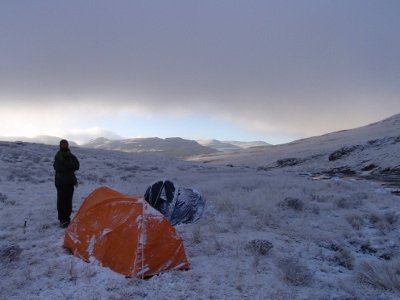
Not a bad view to wake up to. Sadly I had already been up for about 2 hours before getting a proper view, but still
The Cutback covered in a blanket of cloud. Notice the pins in the blanket.
Mponjwane Cave
Ncedamabutho from outside Mponjwane Cave. The map shows the peak right above the cave as the high point. but the middle summit is about 1m higher and roughly the same height as the 3rd one.
The view from the top of Rockeries Pass. Notice Cathedral and the Bell completing a perfect circle of mountains. Excuse the quality - this was my cheap camera.
Rockeries
A waterfall on the way down. I tried to figure out which river was the Nguza river but I still have no clue! Darn mist

Below the mist, but still a long way to go.
The team L-R, notice the support for Movember (don't forget to be aware of prostate cancer) :
Me, Ian/ASL, Stijn, Anton, Joos, Johan and Chris/ccjoubert
Please login or register to view the images attached to this post.
Please Log in or Create an account to join the conversation.
Just a quick correction before everybody thinks we took a really circuitous route - the river we swam in an crossed was the Icidi river and pools. We split the group shortly after Shepherd's Cave and the 5 of us continued up to the base of Pins Pass. On the way, Joost saved the day by catching a calf which was sliding down a wet slab - unfortunately we all agreed that it probably still became somebody's dinner that night.
We started up the true right grassy banks of Pins Pass at 10:45 and soon realised that trail runners were probably not the most comfortable choice of footwear for the steep grassy contouring. They were still a better choice than Joost's Low-Tecs, which had already separated themselves from their soles earlier that day. Nevermind - they make them tough in the Free State. Both boots were wrapped with strapping tape and we pushed on. The going was slow initially but improved once we could finally head directly up the slope near the scree field. It was a beautiful day and we were surrounded by mountains, with the Pinnacles towering above us! We had a brief lunch after turning the corner and then kept soldiering onwards and upwards. I must say, even with light packs, this pass is a beast with relentlessly steep slopes to punish weary legs. It still went faster than it felt, with us making the summit cairn at 13:45, having taken 3h for the ascent.
The clouds and storms still seemed to be staying at bay so we were able to take the scenic route around the cutback, checking out all those spectacular cliffs, waterfalls and gullies. We reached the Orange river for a water top-up as a huge storm cell started moving in from the cutback. The others mentioned something about a swim and that they would have a 10-min warning before the storm broke, but looking around, I took that as my 10-minute warning and set off up the slope for Mponjwane Cave. It turns out my timing was just right as the hail started coming down as I rolled my sleeping bag out at about 16:30. The others joined me shortly and soon we were enjoying McDonals burgers, Bully Beef and varying qualities of whisky. Well deserved after a solid 30km day!

We had assumed that Ghaz & Ian had turned around before heading up the pass and since they were fully self-sufficient, decided that it would not be wise to go looking for them in the storm. Fortunately, they joined us just before dark with plenty of adventures to share.
The early morning mist cleared just on time to allow us a scenic traverse to Nguza Pass above a sea of clouds. We started heading down the steep narrow gully at 7am, and after the grassy ledge traverse, dropped down the side gully into the clouds. For me the most challenging part of Nguza Pass was actually this steep gully as it still seems to be very active, with many loose rocks and sliding scree. The ramps down either side of the chockstone were completely soaked so we used our rope and slings to lower packs and ourselves down this obstacle. Even in the dry, this looks like it would require some teamwork (up or down) so I would defintely still call Nguza a rock pass via this variation. It would be interesting to see if the top part of the gully is fairly passable as it comes out in the nek between the escarpment and North Peak.
More boulder-hopping down a fairly full river took us down to the Rockeries Pass path, which we reached at 09:30. We met up with Ghaz & Ian about an hour later and enjoyed the last bit of slog down the road with them.
P.S. When I mentioned that they make them tough in the Free State, I was not kidding - Johan and Joost had only done one Berg hike before this - a hike to Ifidi Cave via the Chain Ladders. They showed some proper vasbyt (external frame backpacks and Low-Tecs included). As always, it was great to meet some more forum members (Ian, Chris & Jonathan) - I look forward to hiking with you guys again!
Please Log in or Create an account to join the conversation.

Sounds like a great fast light hike was had by all (Ghaz your description of what you were feeling like sounds horrid but been there and done that, well done for hanging on)
Stijn sorry I missed this one, hopefully can join the next one.
Please Log in or Create an account to join the conversation.

Joos showing us how to cross the Icidi pools
The grassy banks of Pins Pass
Johan and Joos celebrating the summit (since Stijn corrected Ghaz with Icidi pass I have to add that credit have to go to the Northern Cape for these guys, where they both grew up)
10 minutes after Stijn's 10-minute warning
5 am start above the clouds
Movember in the berg!!
Going down Nguza
The last trip for these boots
Please login or register to view the images attached to this post.
Please Log in or Create an account to join the conversation.

Ps. I still think Fangs Pass looks easy now that I have looked up it from below
That's a joke on me folks, nice one Ghaz, I can take as good as I give.
(It is a joke? right).
And jolly well done to the Pins Nguza group, your write ups almost make light of what is a long and difficult hike, which a lot of us would have done as a 3 day. (with real boots and "modern" packs).
I would call this a “Baptism of Fire" to the new guys, consider yourselves Bergies and know that your future berg hiking will be a breeze from now on, unless of course you insist on going with Stijn.
Please Log in or Create an account to join the conversation.

Geordie wrote: That's a joke on me folks, nice one Ghaz, I can take as good as I give.
(It is a joke? right).
Please Log in or Create an account to join the conversation.
")
Hiking in the heat is always tough (for me anyway), ghaznavid's experience is a good reminder that even experienced hikers can get into a bit of difficulty quite fast in the 'berg!
Please Log in or Create an account to join the conversation.
Pins and Nguza in my mind used to belong to the list of "mystery passes" of which little is known and which are generally avoided. Due to advent of forums such as these information spreads far more rapidly, and the synergistic effect of a bunch of Berg enthusiasts talking to each other is that we can unlock the hidden and forgotten treasures of the Drakensberg. With this comes a responsibility however. As the Dragon lets us peek into it's liar, we must come to realise that the Dragon is vulnerable and threatened, and not able to always defend itself. As we share in it's secrets, let's also share in the challenge of looking after it, guarding it and ensuring it remains the Dragon that we know for generations to come.
On another note, we have it in writing that ghaz agreed to carry my pack for me next time I do Mbundini...
Take nothing but litter, leave nothing but a cleaner Drakensberg.
Please Log in or Create an account to join the conversation.

intrepid wrote: Pins and Nguza in my mind used to belong to the list of "mystery passes" of which little is known and which are generally avoided. Due to advent of forums such as these information spreads far more rapidly, and the synergistic effect of a bunch of Berg enthusiasts talking to each other is that we can unlock the hidden and forgotten treasures of the Drakensberg.
That was basically what I was getting at with that thread about passes which no one on the forum has done. To me Tsepeng Pass was largely a mystery pass until Elinda's writeup on it. Similar with Judge Pass. Both are actually great passes and aren't particularly difficult. I stand by my rating that Tsepeng Pass is a 7, i.e. harder than Mnweni Pass. Same with Gypaetus Pass.
In my mind some other "mystery passes" that I don't think any VE members have done:
- Inner Tower Gully
- Hilton Pass non climbing route (i.e. bypassing all 3 waterfalls if such a route is possible - I know a VE team did this pass with ropes some time back)
- Thumb Pass
- The Giant's Castle "gully" passes (Eastern Gully, South Gully etc)
- Uklebe Pass
- Plenty of Vergelegen's Passes that include lots of M's and Q's in the name
- Sandleni Pass (perhaps not since there is a GPS track for it)
- Many possibly unopened passes - there is a grassy gully just in from Manxome Pass that I noticed this weekend (other side from Pins Pass), my 5 possible new routes at Giant's Castle (8 in total, but I have done 3 of them so far) etc
Please Log in or Create an account to join the conversation.
