
VE Berg trip 4 - Busingatha Valley
03 Mar 2014 22:16 - 03 Mar 2014 22:17 #59781
by ghaznavid
VE Berg trip 4 - Busingatha Valley was created by ghaznavid
Rock is not always rock solid
The first VE Berg trip of 2014 has been completed. A team of 7 of us set out with the goal of conquering the Inner Tower Gully from the Busingatha Valley. The team was Elijah, Petros (both are local mountain guides and rock art custodians), Chris (Intrepid), Kel (Climbykel), Ian (Diverian), Carl (Viking) and myself.
Donga reclamation
Before setting off for our overnight spot – Busingatha Cave – we were taken to one of the large donga reclamation projects in the area.
Over time, a combination of grazing and heavy use of trails results in channels. When it rains these channels become waterways resulting in rapid erosion. Over time these channels become dongas and result in significant damage to the landscape, as well as the silting up of the rivers below.
To slow this, the amaZizi Wilderness Group and the Africa Conservation Trust have been engaged in a combined effort. Basically rocks from the rivers are used to build erosion barriers in the dongas. This slows the water down, thus reducing the amount of sediment removed. It also provides structural support to the dongas slowing the collapse of the sand walls. Grass is planted above the dongas in an attempt to hold the tops of the wall together.
What distinguishes the necessity for this process from normal erosion is that this erosion is caused by human use of the area.
The state does not fund this project, and only around 17 people can be employed due to financial constraints. This is substantially less than what is needed if this problem is to be seriously addressed.
The amaZizi Wilderness Group has a system where schools visit the community, are introduced to village life and culture. The groups are then shown the donga reclamations and assist in the process. To me this sounds like a great educational tool for schools and really deserves some publicity.
The walk to Busingatha Cave
After visiting a donga site we picked up our guides – Petros and Elijah – and headed off to the local trading store where they had arranged for us to park.
The road to this area is undergoing some heavy construction, possibly in anticipation of the cableway. To reach this area the road to RNNP is followed until a turnoff to the left marked “Busingatha” is reached. This turnoff is probably around 8km before RNNP is reached. The road is initially a concrete road, but becomes gravel after a while. There is a turning circle at the end of the road.
There is no official access procedure to the area, but it is vital that you obtain permission from the Induna before you arrive as it is their land. Use of a guide in the area is also highly recommended – the maps show a simple path from the end of this road to the cave – the path is not continuous, there are other paths in the area. If you don’t know where you are going you can easily get lost.
We set off from where we had parked our cars, and walked to the end of the road. Elijah pointed out to us that the houses near the end of this road are part of the development site. He informed us that these homeowners have been told that they will have to move. These lands have been in their families for generations, their ancestors were buried on these plots. Elijah told us that in the Zulu religion they believe that the souls of their ancestors live in the rondavels, and as most of you will know – their wealth is measured in livestock. The cableway proposal requires that the lands they currently use will no longer be available for their use for grazing. When you look at it from their perspective you can understand why the local community is opposed to the proposal.
A short distance from the end of the road we reached the proposed base station. It is a large, badly eroded area with a wattle infestation – much like they mentioned in the feasibility study. From this spot the proposed intermediate stations become clearly apparent.
When standing at the proposed base station it is immediately clear that the exact spot shown on page 14 of the feasibility study cannot be the actual base station. Well – I guess they could blast a large hole in the mountain or build a very high base station, but quite simply the base station will have to be on top of the ridge, not half way up the side facing away from the mountain!
The real proposed base station has an incredible view. I could easily sit on this spot - munching almonds - for a few hours. For anyone who says that a visit to Mnweni is mandatory – I challenge you to visit this valley. You will not be disappointed!
We followed the rather confusing network of trails for a while, crossing the river many times. We eventually reached the cave – its only about 6km, and doesn’t require much altitude gain.
On the way in we visited a minor rock art site, sadly the rock art had been badly vandalised. There are also quite a few really good looking rock pools on the walk into the cave. Kel kept saying we should stop and swim in one of the pools, but considering what the subsequent pools were like, a good thing we didn’t.
Busingatha Cave (Singati Cave on geomaps series map 1) is a very wide cave, but only has 2 sleeping areas. The first is in the middle of the cave and really doesn’t look good. The higher one on the far end of the cave can sleep around 8 people in summer, but should easily sleep 12 in the dryer months. The floor of the cave is very dusty.
The highlight of the cave, however, is the large pool immediately below the cave. It is relatively deep and has a perfectly placed water slide.
Personally I don’t enjoy swimming in Berg pools – so I assumed the role of videographer for team members going down the slide. Just a warning on the slide – with the exception of Carl, everyone who went down the slide ended up with a hole in their underwear. Perhaps an old ground mat or something like that may be worth taking with.
Chris and I decided to have a look at the route from the cave to the base of the pass as part of our preparation for the following day. There is a trail leading out of the far end of the cave. It goes around an exposed corner, ascends a narrow gully and then traverses the ridge before it disappears below a small and wet cave high above the river.
We got as high as possible on the ridge in order to get a good look at the gully. We then traversed to the higher cave to have a look at it. The river below the cave is probably passable, but doesn’t look easy. The high line below the wet cave requires a traverse through heavy vegetation and a climb high on the ridge will land one on a very steep slope below and above cliffs. We realised that we would have to follow this trail first thing in the morning, work our way through the vegetation and follow the river to reach the Busingatha gully which would lead us to the nek between the escarpment and the Inner Tower.
We also realised that the following day would be long and slow.
Inner Tower Gully – kind of
Leaving the cave at 7AM, Petros staying in the cave with our overnight gear – he had a bad case of the flu and really needed to rest while we slogged up the pass – we set of on the trail from the day before.
On reaching the end of the lower cliff line – the line in which Busingatha Cave is found – we dropped to the severely overgrown field between us and the river. The ground collapsed below us, thorns in the arms and legs, every plant type in the eyes and mouth, we eventually reached the river.
The day before we had agreed that 1km/h would be a good speed on this stretch. Around 1h30 into the route we had done 930m – very slow going indeed!
Once on the river the going became much easier. Every few metres another good rock pool, often with a descent water slide, was found. We kept having to cross the river. This gully would be treacherous if the river was high or after a storm. One must exercise caution when using such a route.
Mount Amery was towering above us, the Singati Wall was equally imposing and really quite something. Soon the mist began to move in and the escarpment began to disappear. The final section before the river makes a 90 degree turn required a higher line on the bank next to the river (true right). At the confluence the river is crossed and the approach gully is taken. Basic navigational guideline to this route: if the river splits, go right (true left).
Initially the rocks of the gully seemed to be pretty stable. Unfortunately the Dragon wanted to teach me a lesson on this particular day. While climbing a bank I put my full weight on a rock – the rock gave way, dropping be down the part I was climbing. The rock landed on my left leg and grazed my right leg. I was lucky to not sustain any bone damage, but it still left 8 separate bruises/cuts on my legs (6 on the one, 2 on the other).
As always – when such an incident happens you generally don’t feel the pain immediately, unless there is a fracture or a break. So we waited for 10 minutes, after which it began to be marginally sore, but nothing serious. I covered each spot with anti-septic cream, and put a bandage on my left leg to prevent my pants from scratching my leg. The team was worried, but I think everyone overestimated the degree of damage I took. In retrospect it is quite something that a rock larger than a soccer ball landed on my leg and did no major damage – as always, a reminder that God is with me, and a reminder to keep praying for his protection.
We pushed on, soon noticing a large rock arch in the cliffs on the true right bank.
The gully itself is not too bad for the most part, but it has a fair number of spots where you have to climb up loose rocks. There is only occasionally a usable grass bank on either side of the gully, for the most part you are stuck in the gully. Around 2700m it starts getting really serious. There is a double waterfall where the gully is very narrow. Chris placed a length of access chord on this section for the team to use if they couldn’t find descent holds. We passed packs up to him, the rock was surprisingly good considering the fact that it moved when I touched it and it was rather wet.
On reaching the top of this first major obstacle, it became apparent that a second such obstacle was above us. My lame excuse: on climbing these two sections of waterfall I had bashed my knee quite badly, and combined with the injury from earlier it was beginning to get quite sore. I was also not trusting my feet after the rock had given way earlier. My pace had also dropped off and we were running late – so I decided that it would be in everyone’s best interest if I was to call it a day at this point. Ian and Elijah did the same, so Chris, Kel and Carl set off still hoping to reach the escarpment.
After around 1h30 the 3 of them returned safely to where we were. Elijah had been sleeping behind a rock, I had listened to the full chapter “A Shaddow From The Past” on my MP3 player (got to love audiobooks), and Ian had had a good break relaxing in the gully. The others had reached the nek between the Inner Tower and the escarpment before turning around. They had had to abseil down the waterfall above where the rest of us were waiting.
We had felt quite trapped and exposed on this spot – we knew we couldn’t downclimb a wet loose waterfall, and we couldn’t up climb the following waterfall without some form of rope support. In the event of a rock fall or flash flood I don’t think we would have been safe in this position.
Once the full team had reunited, Chris set up an abseil off the large bolder that Elijah had been sleeping next to. We all abseiled down the two waterfalls at once, and then began the slog back to the cave.
We were convinced that we would arrive back late, and the gully was tough to downclimb. We made very good time on the gully and were soon at the river below. But it was already well passed 4PM, and time was against us.
The quality of the rock in the riverbed can be summed up by what happened when Ian dislodged a large rock, it fell about half a metre and cracked in half!
As we continued along the lower river, rain was threatening. Fortunately it didn’t pick up and we safely reached the cave as it was getting dark. We took a better line through the vegetation on the way back, but it was still nasty – everyone took at least 2 falls.
So in a 12 hour day of hiking we covered something like 7km. Clearly we were going for a speed record…
We all went down to the river by headlamp, Ian taking another go on the slide. As we left the river it began to rain, but being so close to the cave this was not a problem.
Rock art
After a late start on Monday morning, we began the walk back to the cars. The plan was to visit the famous Mposheni (no clue how to actually spell that) rock art site.
This required a long contouring traverse to reach the site – if you want to visit it, make sure you have a rock art custodian with you. A local guide will have no trouble finding it, but it is very well hidden if you don’t know what you are looking for.
The site has numerous badly worn paintings, but also has a very good quality large eland on its main panel. Definitely worth a visit – probably the best single painting I have seen.
From there the walk to the car was relatively easy. The local community is very friendly.
Photos to follow in the next few days
The first VE Berg trip of 2014 has been completed. A team of 7 of us set out with the goal of conquering the Inner Tower Gully from the Busingatha Valley. The team was Elijah, Petros (both are local mountain guides and rock art custodians), Chris (Intrepid), Kel (Climbykel), Ian (Diverian), Carl (Viking) and myself.
Donga reclamation
Before setting off for our overnight spot – Busingatha Cave – we were taken to one of the large donga reclamation projects in the area.
Over time, a combination of grazing and heavy use of trails results in channels. When it rains these channels become waterways resulting in rapid erosion. Over time these channels become dongas and result in significant damage to the landscape, as well as the silting up of the rivers below.
To slow this, the amaZizi Wilderness Group and the Africa Conservation Trust have been engaged in a combined effort. Basically rocks from the rivers are used to build erosion barriers in the dongas. This slows the water down, thus reducing the amount of sediment removed. It also provides structural support to the dongas slowing the collapse of the sand walls. Grass is planted above the dongas in an attempt to hold the tops of the wall together.
What distinguishes the necessity for this process from normal erosion is that this erosion is caused by human use of the area.
The state does not fund this project, and only around 17 people can be employed due to financial constraints. This is substantially less than what is needed if this problem is to be seriously addressed.
The amaZizi Wilderness Group has a system where schools visit the community, are introduced to village life and culture. The groups are then shown the donga reclamations and assist in the process. To me this sounds like a great educational tool for schools and really deserves some publicity.
The walk to Busingatha Cave
After visiting a donga site we picked up our guides – Petros and Elijah – and headed off to the local trading store where they had arranged for us to park.
The road to this area is undergoing some heavy construction, possibly in anticipation of the cableway. To reach this area the road to RNNP is followed until a turnoff to the left marked “Busingatha” is reached. This turnoff is probably around 8km before RNNP is reached. The road is initially a concrete road, but becomes gravel after a while. There is a turning circle at the end of the road.
There is no official access procedure to the area, but it is vital that you obtain permission from the Induna before you arrive as it is their land. Use of a guide in the area is also highly recommended – the maps show a simple path from the end of this road to the cave – the path is not continuous, there are other paths in the area. If you don’t know where you are going you can easily get lost.
We set off from where we had parked our cars, and walked to the end of the road. Elijah pointed out to us that the houses near the end of this road are part of the development site. He informed us that these homeowners have been told that they will have to move. These lands have been in their families for generations, their ancestors were buried on these plots. Elijah told us that in the Zulu religion they believe that the souls of their ancestors live in the rondavels, and as most of you will know – their wealth is measured in livestock. The cableway proposal requires that the lands they currently use will no longer be available for their use for grazing. When you look at it from their perspective you can understand why the local community is opposed to the proposal.
A short distance from the end of the road we reached the proposed base station. It is a large, badly eroded area with a wattle infestation – much like they mentioned in the feasibility study. From this spot the proposed intermediate stations become clearly apparent.
When standing at the proposed base station it is immediately clear that the exact spot shown on page 14 of the feasibility study cannot be the actual base station. Well – I guess they could blast a large hole in the mountain or build a very high base station, but quite simply the base station will have to be on top of the ridge, not half way up the side facing away from the mountain!
The real proposed base station has an incredible view. I could easily sit on this spot - munching almonds
- for a few hours. For anyone who says that a visit to Mnweni is mandatory – I challenge you to visit this valley. You will not be disappointed!We followed the rather confusing network of trails for a while, crossing the river many times. We eventually reached the cave – its only about 6km, and doesn’t require much altitude gain.
On the way in we visited a minor rock art site, sadly the rock art had been badly vandalised. There are also quite a few really good looking rock pools on the walk into the cave. Kel kept saying we should stop and swim in one of the pools, but considering what the subsequent pools were like, a good thing we didn’t.
Busingatha Cave (Singati Cave on geomaps series map 1) is a very wide cave, but only has 2 sleeping areas. The first is in the middle of the cave and really doesn’t look good. The higher one on the far end of the cave can sleep around 8 people in summer, but should easily sleep 12 in the dryer months. The floor of the cave is very dusty.
The highlight of the cave, however, is the large pool immediately below the cave. It is relatively deep and has a perfectly placed water slide.
Personally I don’t enjoy swimming in Berg pools – so I assumed the role of videographer for team members going down the slide. Just a warning on the slide – with the exception of Carl, everyone who went down the slide ended up with a hole in their underwear. Perhaps an old ground mat or something like that may be worth taking with.
Chris and I decided to have a look at the route from the cave to the base of the pass as part of our preparation for the following day. There is a trail leading out of the far end of the cave. It goes around an exposed corner, ascends a narrow gully and then traverses the ridge before it disappears below a small and wet cave high above the river.
We got as high as possible on the ridge in order to get a good look at the gully. We then traversed to the higher cave to have a look at it. The river below the cave is probably passable, but doesn’t look easy. The high line below the wet cave requires a traverse through heavy vegetation and a climb high on the ridge will land one on a very steep slope below and above cliffs. We realised that we would have to follow this trail first thing in the morning, work our way through the vegetation and follow the river to reach the Busingatha gully which would lead us to the nek between the escarpment and the Inner Tower.
We also realised that the following day would be long and slow.
Inner Tower Gully – kind of
Leaving the cave at 7AM, Petros staying in the cave with our overnight gear – he had a bad case of the flu and really needed to rest while we slogged up the pass – we set of on the trail from the day before.
On reaching the end of the lower cliff line – the line in which Busingatha Cave is found – we dropped to the severely overgrown field between us and the river. The ground collapsed below us, thorns in the arms and legs, every plant type in the eyes and mouth, we eventually reached the river.
The day before we had agreed that 1km/h would be a good speed on this stretch. Around 1h30 into the route we had done 930m – very slow going indeed!
Once on the river the going became much easier. Every few metres another good rock pool, often with a descent water slide, was found. We kept having to cross the river. This gully would be treacherous if the river was high or after a storm. One must exercise caution when using such a route.
Mount Amery was towering above us, the Singati Wall was equally imposing and really quite something. Soon the mist began to move in and the escarpment began to disappear. The final section before the river makes a 90 degree turn required a higher line on the bank next to the river (true right). At the confluence the river is crossed and the approach gully is taken. Basic navigational guideline to this route: if the river splits, go right (true left).
Initially the rocks of the gully seemed to be pretty stable. Unfortunately the Dragon wanted to teach me a lesson on this particular day. While climbing a bank I put my full weight on a rock – the rock gave way, dropping be down the part I was climbing. The rock landed on my left leg and grazed my right leg. I was lucky to not sustain any bone damage, but it still left 8 separate bruises/cuts on my legs (6 on the one, 2 on the other).
As always – when such an incident happens you generally don’t feel the pain immediately, unless there is a fracture or a break. So we waited for 10 minutes, after which it began to be marginally sore, but nothing serious. I covered each spot with anti-septic cream, and put a bandage on my left leg to prevent my pants from scratching my leg. The team was worried, but I think everyone overestimated the degree of damage I took. In retrospect it is quite something that a rock larger than a soccer ball landed on my leg and did no major damage – as always, a reminder that God is with me, and a reminder to keep praying for his protection.
We pushed on, soon noticing a large rock arch in the cliffs on the true right bank.
The gully itself is not too bad for the most part, but it has a fair number of spots where you have to climb up loose rocks. There is only occasionally a usable grass bank on either side of the gully, for the most part you are stuck in the gully. Around 2700m it starts getting really serious. There is a double waterfall where the gully is very narrow. Chris placed a length of access chord on this section for the team to use if they couldn’t find descent holds. We passed packs up to him, the rock was surprisingly good considering the fact that it moved when I touched it and it was rather wet.
On reaching the top of this first major obstacle, it became apparent that a second such obstacle was above us. My lame excuse: on climbing these two sections of waterfall I had bashed my knee quite badly, and combined with the injury from earlier it was beginning to get quite sore. I was also not trusting my feet after the rock had given way earlier. My pace had also dropped off and we were running late – so I decided that it would be in everyone’s best interest if I was to call it a day at this point. Ian and Elijah did the same, so Chris, Kel and Carl set off still hoping to reach the escarpment.
After around 1h30 the 3 of them returned safely to where we were. Elijah had been sleeping behind a rock, I had listened to the full chapter “A Shaddow From The Past” on my MP3 player (got to love audiobooks), and Ian had had a good break relaxing in the gully. The others had reached the nek between the Inner Tower and the escarpment before turning around. They had had to abseil down the waterfall above where the rest of us were waiting.
We had felt quite trapped and exposed on this spot – we knew we couldn’t downclimb a wet loose waterfall, and we couldn’t up climb the following waterfall without some form of rope support. In the event of a rock fall or flash flood I don’t think we would have been safe in this position.
Once the full team had reunited, Chris set up an abseil off the large bolder that Elijah had been sleeping next to. We all abseiled down the two waterfalls at once, and then began the slog back to the cave.
We were convinced that we would arrive back late, and the gully was tough to downclimb. We made very good time on the gully and were soon at the river below. But it was already well passed 4PM, and time was against us.
The quality of the rock in the riverbed can be summed up by what happened when Ian dislodged a large rock, it fell about half a metre and cracked in half!
As we continued along the lower river, rain was threatening. Fortunately it didn’t pick up and we safely reached the cave as it was getting dark. We took a better line through the vegetation on the way back, but it was still nasty – everyone took at least 2 falls.
So in a 12 hour day of hiking we covered something like 7km. Clearly we were going for a speed record…
We all went down to the river by headlamp, Ian taking another go on the slide. As we left the river it began to rain, but being so close to the cave this was not a problem.
Rock art
After a late start on Monday morning, we began the walk back to the cars. The plan was to visit the famous Mposheni (no clue how to actually spell that) rock art site.
This required a long contouring traverse to reach the site – if you want to visit it, make sure you have a rock art custodian with you. A local guide will have no trouble finding it, but it is very well hidden if you don’t know what you are looking for.
The site has numerous badly worn paintings, but also has a very good quality large eland on its main panel. Definitely worth a visit – probably the best single painting I have seen.
From there the walk to the car was relatively easy. The local community is very friendly.
Photos to follow in the next few days
Last edit: 03 Mar 2014 22:17 by ghaznavid.
The following user(s) said Thank You: intrepid, Serious tribe, diverian, Smurfatefrog, Guardian, Viking
Please Log in or Create an account to join the conversation.

04 Mar 2014 10:43 #59784
by ClimbyKel
Replied by ClimbyKel on topic VE Berg trip 4 - Busingatha Valley
This was an absolutely awesome trip - thanks to all of you guys! My favorite parts were learning from the locals who accompanied us: Petrous and Elijah. And also I truly enjoyed the spectacular views and never-ending rock pools.
The locals are very warm and inviting; they also showed themselves to be incredibly intelligent and thoughtful about keeping their land clean and protected. I learned a lot and gained an enormous amount of respect for this Zulu community.
About the hike itself: here's some fair warning. As you know, I am married to a true explorer in every sense of the word. Intrepid has taken me on many (I call them "epic") long hikes. Our first ever hike together was in Canadian snow, 17 hours, 37 km, and we got tracked by a wolf. So, this all considered, and taking into consideration that we only had 1 long & hard "epic" 12-hour day....well, I cannot complain. But I really was exhausted by this one! And I was definitely ready for that end-of-day dip in the pools again!") Maybe this is in part because of no exercise leading up to this hike (this is the first thing I did post-broken-toe. But, it is also because it's truly a long and tough hike. One I do not recommend to anyone who isn't geared up for a very long day, and a really hard slog! You also must be okay with boulder hopping, scrambling, and a bit of easy (roped) climbing. You must also have underwear that can be retired after a few bum slides into the rock pools, and some ointment for abraisons to your bottom! I have my first bum roasty, and although it's scabbed over now - but the size of my hand and still looks funny. This gave Intrepid a good laugh as I climbed into my bath last night.
Maybe this is in part because of no exercise leading up to this hike (this is the first thing I did post-broken-toe. But, it is also because it's truly a long and tough hike. One I do not recommend to anyone who isn't geared up for a very long day, and a really hard slog! You also must be okay with boulder hopping, scrambling, and a bit of easy (roped) climbing. You must also have underwear that can be retired after a few bum slides into the rock pools, and some ointment for abraisons to your bottom! I have my first bum roasty, and although it's scabbed over now - but the size of my hand and still looks funny. This gave Intrepid a good laugh as I climbed into my bath last night.
The locals are very warm and inviting; they also showed themselves to be incredibly intelligent and thoughtful about keeping their land clean and protected. I learned a lot and gained an enormous amount of respect for this Zulu community.
About the hike itself: here's some fair warning. As you know, I am married to a true explorer in every sense of the word. Intrepid has taken me on many (I call them "epic") long hikes. Our first ever hike together was in Canadian snow, 17 hours, 37 km, and we got tracked by a wolf. So, this all considered, and taking into consideration that we only had 1 long & hard "epic" 12-hour day....well, I cannot complain. But I really was exhausted by this one! And I was definitely ready for that end-of-day dip in the pools again!
Maybe this is in part because of no exercise leading up to this hike (this is the first thing I did post-broken-toe. But, it is also because it's truly a long and tough hike. One I do not recommend to anyone who isn't geared up for a very long day, and a really hard slog! You also must be okay with boulder hopping, scrambling, and a bit of easy (roped) climbing. You must also have underwear that can be retired after a few bum slides into the rock pools, and some ointment for abraisons to your bottom! I have my first bum roasty, and although it's scabbed over now - but the size of my hand and still looks funny. This gave Intrepid a good laugh as I climbed into my bath last night. Please Log in or Create an account to join the conversation.

04 Mar 2014 11:23 #59785
by firephish
Replied by firephish on topic VE Berg trip 4 - Busingatha Valley
sounds like an interesting hike, where are the pics?
also will you guys make a GPS track available?
also will you guys make a GPS track available?
Please Log in or Create an account to join the conversation.
04 Mar 2014 11:28 #59786
by ghaznavid
Replied by ghaznavid on topic VE Berg trip 4 - Busingatha Valley
I'll get photos up soon, but for a start - here's a videos of Ian on the slide:
Please Log in or Create an account to join the conversation.
04 Mar 2014 13:07 - 04 Mar 2014 13:31 #59787
by ghaznavid
Replied by ghaznavid on topic VE Berg trip 4 - Busingatha Valley
Donga reclamation
The donga site we were shown is in a really bad state:
The hike
A house near RNNP
Tugela Falls flowing strong
The trading store where we parked
The road that is planned to lead to the cableway base station is currently under construction. The houses in this photo will have to be demolished if the project goes ahead. Apparently officials told the homeowners that they will have to "learn to live with it"
The erosion near the proposed base station is pretty bad
The area quoted in the feasibility study as the base station
The view towards the escarpment from the proposed base - to me it is apparent that this is actually not the proposed base station
The view from the top of the hill which is probably the actual base station site
The view from the proposed base station. This spot is relatively easily accessible - but I imagine some form of escalator would be built to facilitate disabled individuals reaching the base station as there is a hill to climb to reach this spot.
Elijah enjoys the views as he tells us about how the late chief had come to this spot in his last few days - he promised his people that he would never let the project go ahead. The "public consultation" in the area was conducted during the 10 days of morning for the late chief.
In terms of the cableway proposal, this land will not be available for grazing use if the project goes ahead
One of the many sequences of waterfalls and pools. There is a really nice pool just below this.
This rock art site has unfortunately seen a degree of vandalism
The valley in which the cave is found is heavily vegitated and has incredibly steep slopes. The side seen from the cave includes a very high sheer cliff
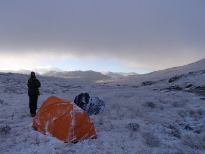
Busingatha Cave
Busingatha Pool complete with a slide (see video above)
The view from near the cave
Another pool on the river
A small pool with a waterfall flowing into it
Mount Amery towers above us - shortly after this the mist moved in
Yet another pool on the approach to the pass
Entering the gully after a long slog up the approach
The donga site we were shown is in a really bad state:
The hike
A house near RNNP
Tugela Falls flowing strong
The trading store where we parked
The road that is planned to lead to the cableway base station is currently under construction. The houses in this photo will have to be demolished if the project goes ahead. Apparently officials told the homeowners that they will have to "learn to live with it"
The erosion near the proposed base station is pretty bad
The area quoted in the feasibility study as the base station
The view towards the escarpment from the proposed base - to me it is apparent that this is actually not the proposed base station
The view from the top of the hill which is probably the actual base station site
The view from the proposed base station. This spot is relatively easily accessible - but I imagine some form of escalator would be built to facilitate disabled individuals reaching the base station as there is a hill to climb to reach this spot.
Elijah enjoys the views as he tells us about how the late chief had come to this spot in his last few days - he promised his people that he would never let the project go ahead. The "public consultation" in the area was conducted during the 10 days of morning for the late chief.
In terms of the cableway proposal, this land will not be available for grazing use if the project goes ahead
One of the many sequences of waterfalls and pools. There is a really nice pool just below this.
This rock art site has unfortunately seen a degree of vandalism
The valley in which the cave is found is heavily vegitated and has incredibly steep slopes. The side seen from the cave includes a very high sheer cliff
Busingatha Cave
Busingatha Pool complete with a slide (see video above)
The view from near the cave
Another pool on the river
A small pool with a waterfall flowing into it
Mount Amery towers above us - shortly after this the mist moved in
Yet another pool on the approach to the pass
Entering the gully after a long slog up the approach
Please login or register to view the images attached to this post.
Last edit: 04 Mar 2014 13:31 by ghaznavid.
The following user(s) said Thank You: Serious tribe, ruthtbl
Please Log in or Create an account to join the conversation.
04 Mar 2014 13:35 - 04 Mar 2014 13:46 #59788
by ghaznavid
Replied by ghaznavid on topic VE Berg trip 4 - Busingatha Valley
A waterfall in the pass gully
Looking back down the gully
Slow progress up the gully
A large rock arch visible from the gully
Looking down at the rock arch
In places the rock gets very steep by pass standards
The view from the gully is quite something
A large obstacle in the gully - Ian, Elijah and I sat just above this while the others continued to the nek
Elijah abseils down the large obstacle
Mount Amery comes into view as the mist clears
We exit the pass gully thinking that we will have to complete the hike by headlamp
The view from the top corner of the cave
The inside of the cave
The valley below the cave
Yet another pool
The irony of the remark that when the base station is in the mist the upper station will be above the clouds. The mist partially cleared a bit later leaving only the upper station site and its surrounds in the mist!
Petros leads the team at a brisk pace dispite a bad case of the flu
The rock are we were lead to was really worth a visit
The team: L-R - myself, Petros, Carl, Ian, Chris, Kel and Elijah
Cattle crossing the river
Please login or register to view the images attached to this post.
Last edit: 04 Mar 2014 13:46 by ghaznavid.
The following user(s) said Thank You: Serious tribe, Geordie, diverian, Stijn, JonWells, Frosty Ice, firephish, tonymarshall, Guardian, pfoj, ruthtbl, Richard Hunt, wildingo
Please Log in or Create an account to join the conversation.
04 Mar 2014 14:51 #59789
by ClimbyKel
Replied by ClimbyKel on topic VE Berg trip 4 - Busingatha Valley
Everyone is working today....pics to come
Please Log in or Create an account to join the conversation.
05 Mar 2014 09:45 #59791
by Viking
“Today is your day! Your mountain is waiting, So… get on your way!”
Replied by Viking on topic VE Berg trip 4 - Busingatha Valley
Some of my pics. More of the same mostly.
Our meeting point, the cultural centre opposite the Busingatha turn off.
View from the cultural centre.
The group heading off:
Domestic life gives way to wilderness
Hiking in to the cave.
Our meeting point, the cultural centre opposite the Busingatha turn off.
View from the cultural centre.
The group heading off:
Domestic life gives way to wilderness
Hiking in to the cave.
“Today is your day! Your mountain is waiting, So… get on your way!”
Please login or register to view the images attached to this post.
Please Log in or Create an account to join the conversation.

05 Mar 2014 09:51 - 05 Mar 2014 09:54 #59792
by Viking
“Today is your day! Your mountain is waiting, So… get on your way!”
Replied by Viking on topic VE Berg trip 4 - Busingatha Valley
The pools below the cave.
Starting day 2 with a climb up from the cave.
Boulder hopping, bundu bashing and trail-blazing!
Climbing the steeper rockier parts of the gully
Getting misty near the neck.
Intrepid reaching the neck at the top of the gully.
Starting day 2 with a climb up from the cave.
Boulder hopping, bundu bashing and trail-blazing!
Climbing the steeper rockier parts of the gully
Getting misty near the neck.
Intrepid reaching the neck at the top of the gully.
“Today is your day! Your mountain is waiting, So… get on your way!”
Please login or register to view the images attached to this post.
Last edit: 05 Mar 2014 09:54 by Viking. Reason: mix up of labels
The following user(s) said Thank You: Serious tribe
Please Log in or Create an account to join the conversation.
05 Mar 2014 10:02 #59793
by Viking
“Today is your day! Your mountain is waiting, So… get on your way!”
Replied by Viking on topic VE Berg trip 4 - Busingatha Valley
ClimbyKel reaching the neck.
Sentinel from the neck.
Inner Tower from the neck
Cathedral Peak visible from the gully. Cathkin and Sterkhorn were also visible.
Rope-work getting down some parts.
Leaving the main Gully
Sentinel from the neck.
Inner Tower from the neck
Cathedral Peak visible from the gully. Cathkin and Sterkhorn were also visible.
Rope-work getting down some parts.
Leaving the main Gully
“Today is your day! Your mountain is waiting, So… get on your way!”
Please login or register to view the images attached to this post.
Please Log in or Create an account to join the conversation.
