Wet tortoises and binoculars
The weather forecast isn’t great for day 1 – around 5mm of rain expected and cloudy all day. But day 2 is set to be perfect weather, maybe a bit of rain around midday.
The group is made up of 6 of us. Dave Gay is leading the team. It is a GT training hike – maybe I wouldn’t have signed up if I knew this, after all, my 2013 exercise regime is yet to get underway. I should be on my treadmill by Wednesday this week. But having signed up for the hike on the Monday before it happened, and then having the busy week I had, I hoped that the hikes I had done over the past month would be enough.
The rest of the team was made up of 2 first time GT members – both excited for the 14 days of hiking they have coming up, the one being 15 years old. The group also incuded 2 ladies, neither of whom plan to do the GT this year. Elinda being the only other VE member in the team.
We head off from the car park – nice light packs with no tents. I also decided to leave my gas stove at home; after all, you really don’t need it on a 2 day summer hike. It just takes longer to make breakfast in the morning and takes up space in your pack. My pack was probably about 12kg with water.
We cross the newly constructed bridge over the Mlambonja River on the way up towards Little Rhino. We plan to overnight in Fun Cave, but being summer and with the volumes of rain, the MzimkhuluPipeline is probably not a safe option.
We gain about 150m metres on a good path before Dave leads us up the bank next to the path. We climb ridge after ridge, traversing to the next ridge. Soon we are in the mist. There is no path and we are far from the GPS track route. We follow steep narrow gullies and traverse around rock bands. We continue to climb till eventually we are directly below the Little Rhino, roughly 2420m above sea level. I think to myself – the cave is at about 2150m, I see why this isn’t the standard approach.
We begin to traverse. I look up to where I know Rhino Peak is hiding in the mist. Rhino Pass is in the gully in the distance – also hidden in the mist. We drop a bit of altitude heading toward Rhino Pass, stopping for lunch by the river that comes down the pass.
There had been a bit of rain in the morning, but not much. Shortly after lunch the rain picked up again – and didn’t stop. So much for the 5mm we were expecting.
We traverse out on the Verkyker Buttress in thick mist. We begin to gain altitude again until we go above 2500. At this point I think how sad it is that we are about to lose so much altitude and then regain it all tomorrow morning. I guess that was probably more by design than anything else – after all this was a hike to prepare 2 first time GT members.
With rain bucketing down and mist everywhere we eventually start to drop down into the river valley in which Fun Cave is found.
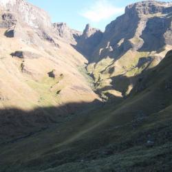
As we come through the mist I see the amazing sandstone buttresses that full this valley – wow! With the rain I can’t take photos, but that doesn’t stop me from admiring the view.
We spend a while getting through a large rock band, but soon enough, a group of drenched hikers reach the river that flows down Verkyker Pass and soon find the path that leads to a cave that seems to be fun.
It took us roughly 7 hours to complete this 11km distance. Elaine (Elinda) and I joke about how the hike write-up should be called “Wet gorillas in the mist”. I feel more like a tortoise with the lack of speed.
Dave discusses the possibilities for the next day with the rest of us; we agree that there is no point in going any further if it is still raining in the morning. Mashai Pass is an option if Rhino Pass is too wet.
The top half of the cave is progressively getting wetter as more and more rain splashed into the cave and water begins to run down the path into the cave. I am forced to relocate my bed to the other end of the cave. The other side is muddy indeed.
Fun Cave is a very dusty cave and its floor is not very flat. The cave itself has a descent view, but nothing particularly impressive. As the sun sets the rain continues.
The next morning the weather is looking perfect – not a cloud in the sky. With no gas stove I end up being ready long before everyone else in the group and end up walking the first few hundred metres ahead of the group to get some photos. What a beautiful morning!
We slowly gain altitude as we approach North Mzimkhulu Pass. The pass doesn’t look as easy as I expect it to be, but as we get closer it begins to look more and more doable. No Man’s Peak (complete with the old plane wreckage) stands out proudly to our north. Memories of day 2 of GT2012 come to mind.
Soon we are gaining altitude fairly quickly. The pass is nowhere near as steep as most Berg passes, but by the same token, not as easy as Langies.
The path is good the entire way up and navigation is easy in the clear weather. The GT team members pull far ahead while I stop frequently to take photos – usually roughly halfway between the other guys up ahead and the ladies behind.
On the way up I see numerous lizards. One even hangs around for long enough that I can get a photo.
The pass is very scenic, well worth doing.
As we near the top I notice a familiar looking waterfall. I soon realise that I know it from the first entry in the “How about a Berg photo quiz” thread.
As the pass tops out I look at my old nemesis – No Man’s Peak. From this angle I can see why I was initially saying that the 2 peaks might be sufficiently separate to constitute separate khulus. While the summits are very close, there is a large cut back between them. Dave tells me that he refers to the lower one as “No Woman’s Peak”.
Myself and Otto decide to climb Verkyker Peak. The rest of the group plans to meet us above Rhino Pass.
I soon find myself high on a ridge with Verkyker Pass between myself and the khulu I am aiming at. A Lammagier is flying around the top of the pass. The pass looks steep, but the view from the top is quite something.
I am soon past the top of the pass, and now far behind the group. I slowly slog up the steep slopes of this monster khulu – it reminds me of my old Popple peak. Slowly I reach the large rock face below the summit. I traverse around until I finally find the way to the top. Otto and the younger of the two Dave’s are on top of the khulu.
I see why this peak is called “binoculars” – that is quite a view up there. Looking down on Rhino, and across my favourite valley, although most of it is hidden behind Mlambonja. In the distance the 2 Leqooa peaks stand out, looking steep and mighty. I look forward to standing on top of them someday.
We head down the south slopes of the khulu and find some locals hanging around the top of Rhino Pass. There are sheep on the peak and locals sitting along the buttress.
We have a group discussion, Dave gives us 2 options: climb Rhino and go down Mashai Pass, or go down Rhino Pass. 5 votes for Rhino Pass vs. 1 vote for Rhino Peak.
We begin to descend Rhino Pass. The pass is fairly wet, the rock and gravel is very loose. The gully is narrow, and navigation isn’t difficult. The feeling that is hunger begins to creep in. I know from past experience how it goes when I don’t eat at this stage, first that feeling goes away, then I struggle to eat and feel nauseous, and soon I’ll not be feeling ok to continue walking. I ask Dave when he plans to stop for lunch – he says that 11AM is far too early and he doesn’t want to stop in the gully.
We continue going down, my concentration, as it always does when I am this hungry, begins to fail. I start to trip over small objects. I decided to stop and eat something – I can catch up pretty quickly with them going so slowly on this downhill terrain. Afterall steep downhill is one of the few terrain types where I am faster than the average hiker.
I stop and eat the highest energy containing item I have – a piece of Woolworths fudge and pecan-nut shortbread. I stand up and get going again.
I gradually get closer to the 3 at the front of the group, using controlled falling as a quick way of getting down the steep grassy banks between 2800m and 2650m.
We eventually stop for lunch. I drink a large amount of water and eat a fair volume of food. Before long we are off again. After the amount of pathless hiking the feet are getting sore. I know there is a path in the near future, so that’s something to look forward to.
As we drop below eye level with the rock bands on Little Rhino we begin to traverse out of the pass gully. I think to myself – that’s comparable to Bannerman Pass, not Tsepeng Pass. I rate the pass as no harder than 5/10. It’s just that the pass is covered in loose ground, which slows it down substantially. The pass is very scenic though.
I look up at the Rhino, mist has begun to settle on the escarpment, so the summit is out of view. What a peak that is. I have never thought of it as a khulu with an exceptional view, but the views from nearby peaks and the areas below surrounding it are always worth the effort.
Now we begin the slow long traverse across the Small Berg back to the start. We gradually enter and exit every little gully formed by the tributaries of the river that flows down Rhino Pass. We find a path, but it only lasts for a few hundred metres before we once more are walking on the typical unflat ground of this area.
Shortly thereafter the path starts again, and soon we are all ambling along in autopilot as we approach the Little Rhino. Near the point where the path crossing the ridge under the Little Rhino I realise that I have lost my cell phone. I walk back about half a km, but am unable to find it. It could be anywhere, on the pass, including on the exit of the pass where there is no path. Considering that it’s my old phone, I am not too worried about how I won’t have the phone any more, but that is some pretty ugly litter and a real shame for something like that to be in this largely unvisited area.
Shortly after passing below the Little Rhino we begin to descend – little did I know that we wouldn’t have a path again till right near the end.
My extra 1km looking for my phone put me far behind the group and only at this point where we dropped off below the Little Rhino did I catch the ladies. The rest of the guys had disappeared far into the distance. We descended the first ridge, traversed it and then dropped down into a narrow gully. Dave waited for the team to be back together before heading off again, but after a short space of time he was far ahead again.
A skaapsteeker tried to flee from us as we dropped down a gully, but strangely it took a sharp turn and smashed into the side of my shoe on its way to the other side of where I was standing. I’m not really sure what it was trying to do. Perhaps if I didn’t lift my foot it was planning on trying to bite me. Strange actions for a timid rear-fanged species of snake.
We continued down, 1 ridge at a time. The younger of the 2 Dave’s had been sent back to make sure that we knew where to go, but soon he disappeared into the distance again.
I could have probably kept up with the other guys – their pace was fast, but it was terrain on which you could easily run down without much effort (aside from the snakes). But I saw no reason to race back when I could get photos. I was also a bit concerned as one of the ladies wasn’t feeling well, and if there was some sort of emergency at least she would have had Elaine and I to help her get to safety.
Eventually – after a day of 21km, roughly 1.2km of altitude gain and 1.6km of altitude loss we reached the car park. How good was it to see that final bridge again.
Being in a tired state, and jumbling my words I was happy to be at the car park. Considering the lack of training for the hike I don’t think I did badly, but it was a good hike, probably would have been better if I was sufficiently fit at the time.
The stats:
Total distance: 32km
Total altitude gain (gross – estimated): 2km
Highest altitude achieved: 3164m
Total photos: 394
Please login or register to view the images attached to this post.
Please Log in or Create an account to join the conversation.

Please Log in or Create an account to join the conversation.
 By the way, in addition to the carbs in my bladder, i always have about two packs of liquorice or other sugary sweets in a small pouch on my hip belt. These are eaten during the day and replaced for each new day. It certainly helps to keep the energy levels up between main meals. Just a thought
 Please Log in or Create an account to join the conversation.
- Serious tribe
-

- Offline
- Platinum Member
-

- Posts: 1064
- Thank you received: 782
Serious tribe wrote: you are getting up to the berg way to often....
that was 3 times in 5 weeks! I'll probably have to pull out of Dave's next hike (up Jarding Pass down Giant's Pass on the first weekend of Feb), but I am still going up Thumb Pass and down North Hlubi Pass in 5 weeks... I can definitely feel the difference on my work, too much energy and time consumed in the Berg can easily become an unhealthy addiction. I'll soon be back into my once every 4 to 6 weeks routine - it will also give me some time to get properly back into my rock climbing and wargaming.
Serious tribe wrote: By the way, in addition to the carbs in my bladder, i always have about two packs of liquorice or other sugary sweets in a small pouch on my hip belt. These are eaten during the day and replaced for each new day. It certainly helps to keep the energy levels up between main meals. Just a thought
Thanks for the tip. I haven't tried liquorice for hiking before. I did use an energy supplement in my water, but I usually use mini cheddars in my pocket. Since they have MSG I was trying to use MSG free chips in my pocket instead - it didn't work at all.
Please Log in or Create an account to join the conversation.
I am so excited about finishing my upcoming trip with this Pass... bring on September...
Please Log in or Create an account to join the conversation.
- Stockhausen
-

- Offline
- Senior Member
-

- Posts: 37
- Thank you received: 4
Stockhausen wrote: @Ghaznavid - your pics are stunning! Your night in the wet cave sounds rather stressful though - did you get any sleep?
Thanks

The top part of the cave was very wet, when I moved to the other side it was damp enough to dirty all my gear, but not so wet that I didn't have a good night sleep. The water splashing my gear from the dripping off the lip of the cave also wasn't reaching me. My clothes drying below where I was sleeping ended up very wet though, so I imagine that if they weren't there, I may have ended up fairly wet.
Please Log in or Create an account to join the conversation.