
- Forum
- Drakensberg Forum
- Drakensberg Trips
- Garden Castle
- Walkers Pass/Andre’s Knob: The Winds of Winter
Walkers Pass/Andre’s Knob: The Winds of Winter
14 Jul 2015 15:31 #64537
by ghaznavid
Walkers Pass/Andre’s Knob: The Winds of Winter was created by ghaznavid
Walkers Pass/Andre’s Knob: The Winds of Winter
As most of you will know – Walkers Peak is where the main High Berg escarpment comes to an end. Oddly enough this ridge is one of the higher ridges – for those who have never stood on top of Walkers Peak, make a plan to get there. To stand on a peak above 3300m with a drop to about 2600m on one side and to just below 3000m on the other side, before rising to Tsepeng (3431m).
At the bottom end of the Barrier of Spears, once the 3000m escarpment has come to an end, there is a free standing peak on the narrow strip that is the watershed. From Tarn Cave it looks like a big pointy pinnacle. I have tried to find info on the origins of this peak name, records of accents or any general information on the peak. But from April 2012 till January 2015 I could find very little information on this peak.
I took photos of this mountain from the top of Thaba Ngwangwe, from Isicutula Pass, Thamathu Pass, Walkers Peak and any other angle I could find – and all this research availed little. I quickly found that there was a ledge that could be used to get up to the summit, but that a cliff separated the ledge from the ridge above Isicutula Pass.
On 3 January 2015 I stood near the top of Isicutula Pass and watched AndrewP bag this summit. On his return he informed me that there may be a grassy ledge on the SA side that one can use to get up this peak. This was a thought that I knew I would have to act on. I had tried every line I could think of from the top and Lesotho side, concluding there was no way up on that side without ropes.
Not even Popple Peak held the top spot on my Berg to-do list for as long as this summit.
So myself and Dave (daveconwaykzn) set off to Garden Castle with the objective of conquering Andre’s Knob.
At the car park we found that we were not the only ones hoping to use Curtain Cave on this Friday night. As we left the car park, there were large fires burning on the side of Rhino – firebreak season is clearly here.
The walk through the Hidden Valley always comes with a great view, the weather was hazy, but not bad. We soon found ourselves through the Hidden Valley and going on the trail to Curtain Cave. The main trail, contrary to what the map shows, goes up the valley south of the Mzimude Pass valley. We knew this, but seeing as this trail leads to Curtain Cave (which is not where the map shows it to be), we stayed on this trail.
Soon the valley narrows and gets steeper, and before you know it, there is a large overhang with the pattern of a curtain on its roof.
The cave is massive overhang, but isn’t entirely flat and has quite a small sleeping area. In summer it wouldn’t be the best cave around.
Just around the corner from Curtain Cave (literally about 20m away) is Wave Cave, and just across from there one finds another reasonable overhang.
During the night the wind began to howl outside. Fortunately Curtain Cave has massive rocks outside it, so very little wind was felt in the cave, but the noise is unmistakable.
Saturday morning and we were up and walking around sunrise. Walkers Pass can be approached from the north or the south (called the Mzimude Gully or the Walkers Ridge routes). We opted for the north/Mzimude Route. Strictly speaking one should follow the approach to Mzimude Pass to reach this route, but we opted to use the approach I had used on Mzimude Pass a few years back.
We took the right side of the Cobra, the wind was howling, but the small Berg was reached after a while.
From the top of the ridge we traversed around to the Mzimude Pass gully. Walkers Pass follows this gully till you reach the waterfall near the base of Mzimude Pass. Just before this scree field and cliff, there is a side gully that is used to get above the lower cliff line. The official start of the pass is marked by a large boulder – sounds arb, but it is easy to spot as it is much larger than any other boulder in the riverbed.
The initial gully is almost 100m vertical and is very steep. Upon topping out you reach a massive grassy slope leading to an obvious saddle and break in the cliff line.
The slog up this slope isn’t too bad, but a howling wind doesn’t help.
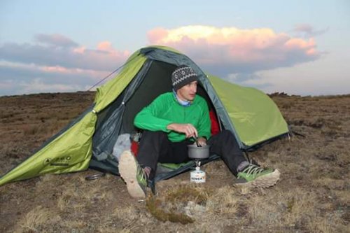
Upon reaching the gully, there is a large cave to the left (true right). It is in a small cutback and down a small slope. It has 2 walled off sleeping areas, both could sleep 2, but barely. We had to do some “gardening” to get it to a point where we could use it.
Dave wasn’t up for hitting Andre’s Knob, so I set off. A short 3m climb put me at the top of the gully, but technically not the escarpment (although it depends on how you define the escarpment). From here I traversed around the Walkers Ridge. There were bits of snow around, and the ground was loose in places – this combined with the wind resulted in a few minor slips. In photos the ledge looks very wide, but it is at quite a slope and above a cliff, so you don’t want to fall on this ledge.
After what was much further than I thought it would be, I rounded a corner and found myself on the elusive Andre’s Knob access ledge. The ledge was pretty straightforward, but knowing that help was at least 3km away, and the wind was howling on this narrow ledge – I took this one slowly and carefully.
After a few scrambles I found myself on top of a narrow ridge with an exceptional view. I proceeded to the destroyed cairn that marks the high point of the peak. I took some photos, sat down and sent the obligatory sms “I just climbed Andre’s Knob”. Then I scrambled back down, only to realise I had forgotten to get my summit photo. So back up I went and got my summit shot before going back down.
On the way back I found a small cave with a massive wall and a large supply of firewood inside. I had always thought that this area of the escarpment would serve no purpose to locals – I have never seen locals in the Leqooa valley, and the Walkers Ridge/Isicutula region would be a slog up a hill with little benefit – so this surprised me.
The wind was still howling, but I found Dave sitting outside the cave enjoying the last sunlight of the day. The cave has a great view to the north.
After collecting some snow to use for cooking supper, I got into my sleeping bag to allow myself to warm up a bit – this icy wind was, well, icy.
After finding that 1.7 litres of snow equates to roughly 700ml of water (even after shaking it in the bottle while filling it, i.e. to get more in), and learning that snow becomes a solid block of ice before it melts, and letting it boil for 5 minutes to kill any nasties that may be living in it – I enjoyed a nice warm supper before calling it a day.
The wind was so strong during the night that it actually shook my mattress, even though I was behind a stone wall right at the back of the cave. Otherwise I could just hear the wind.
The next morning I decided to go for a walk to the top of the watershed – just because Walkers Pass is marked as finishing up there, not at the top of the main gully (which is 3050m vs 3200m on the watershed). In a much stronger wind than the day before I slowly made my way up. Upon reaching the top I could not breathe or stand in the wind. I tried to get some photos, but all I could do was get back off the top as quickly as possible.
As I had suspected, the cold front was here. I could see it roughly 10km away. I didn’t know how long it would take to reach us, but what I did know is that I didn’t want to be on top of the Berg when it did.
When I got back down to the cave I was nice and warm after jogging down the slope. Dave was ready to go, and 10 minutes later, so was I.
Upon reaching the narrow gully I noted that it would be easy for someone to use the wrong gully if they didn’t know the route and had decided to come down the pass, so I built a cairn to mark the correct gully. My not-exceptional cairn building abilities were once again displayed as the cairn was barely visible. But perhaps it may help someone someday. Oddly enough this pass did not have a single cairn – no summit cairn, no route cairns. I know it has been used before, I know at least 3 people who have used this pass, so this was rather odd. With the howling wind I didn’t build a cairn on the watershed, and I didn’t feel that the 3050m gully was the top of the pass, so I didn’t build a summit cairn either.
By 9AM we were already back down on the Mzimude Pass route. We took a break behind the massive boulder that marks the pass – a respite from the wind was most welcome.
I had decided to follow the route that the map shows to get down to the Hidden Valley. We stayed on the true left bank of the river, only leaving the river to bypass the small waterfalls found high up. After a while we hit a big obstacle, not a particularly high waterfall, but it took some scouting to find a route that didn’t require jumping at least 1m down a cliff above water.
Eventually when I found a gap, we found a clear trail. It was actually quite eroded. It also lasted about 20m before it did what most southern Berg trails do. We found bits of trails in places, but once below the main cliffs, we just followed the river and after a lot of relatively slow moving, we eventually hit a clear trail through the last 1km before it joins the Curtain Cave trail. Oddly enough, the trail dies about 300m short of the other trail – explaining why I had never found this trail before.
So perhaps the map wasn’t entirely wrong, at some point there may have been a good trail up this valley. But that doesn’t change the fact that the map is quite misleading in this region as following the trail will end you in a different valley to the one shown on the map. Also, Curtain Cave is still in the wrong side of the wrong valley facing the wrong direction. And as much as a map and a compass may be of use in some situations, it would never show you where the trail is or how to get through a cliff line such as this. While we had no GPS track, in this situation a GPS does what a compass and map can’t do. Fortunately for us, we found the line and it turned out well.
On our walkout through the Hidden Valley we bumped into another group of 2. Turns out that Bigsnake had spent the night in Mzimude Cave. Always nice to see another VE member in the mountains!
As we reached the car park, the ominous looking clouds were over the mountains, but we knew we had beaten the cold front back – the winds of winter had howled for the past 2 days, but the snow they were bringing didn’t catch us in its grasp.
So my thoughts on Walkers Pass – the view from the top is great, Corn Cob Cave is nice, and in summer will be about 200m from flowing water, the pass is also pretty easy. If you are looking for something different, this pass will most certainly give you that – it is not your standard Berg gully by any means. That being said, I can think of a lot of routes I would recommend ahead of this one.
I got a good look at the south route – it looks like you just need to find a gap in the small Berg cliffs of Bushman’s Nek and then follow the large grassy slope to the top, doesn’t look like a tough pass at all.
Andre’s Knob is a great peak, but is really in the middle of nowhere and does require a lot of effort to get up. For the avid peak baggers or people who are conveniently nearby, I recommend it, but just account for the fact that it takes a lot of time to get to and up.
Overall it was a great trip, most of my goals for the weekend were completed. However, a new potential khulu has come onto my radar – Walkers Pass Peak – and for the moment, I can’t confirm its khulu status as there is no height for it. All I know is that it is above 3050m and within 1km of the 3096m Isicutula Peak. If it is higher, it is a khulu and Isicutula will fall off the list. If not, then it isn’t…
As most of you will know – Walkers Peak is where the main High Berg escarpment comes to an end. Oddly enough this ridge is one of the higher ridges – for those who have never stood on top of Walkers Peak, make a plan to get there. To stand on a peak above 3300m with a drop to about 2600m on one side and to just below 3000m on the other side, before rising to Tsepeng (3431m).
At the bottom end of the Barrier of Spears, once the 3000m escarpment has come to an end, there is a free standing peak on the narrow strip that is the watershed. From Tarn Cave it looks like a big pointy pinnacle. I have tried to find info on the origins of this peak name, records of accents or any general information on the peak. But from April 2012 till January 2015 I could find very little information on this peak.
I took photos of this mountain from the top of Thaba Ngwangwe, from Isicutula Pass, Thamathu Pass, Walkers Peak and any other angle I could find – and all this research availed little. I quickly found that there was a ledge that could be used to get up to the summit, but that a cliff separated the ledge from the ridge above Isicutula Pass.
On 3 January 2015 I stood near the top of Isicutula Pass and watched AndrewP bag this summit. On his return he informed me that there may be a grassy ledge on the SA side that one can use to get up this peak. This was a thought that I knew I would have to act on. I had tried every line I could think of from the top and Lesotho side, concluding there was no way up on that side without ropes.
Not even Popple Peak held the top spot on my Berg to-do list for as long as this summit.
So myself and Dave (daveconwaykzn) set off to Garden Castle with the objective of conquering Andre’s Knob.
At the car park we found that we were not the only ones hoping to use Curtain Cave on this Friday night. As we left the car park, there were large fires burning on the side of Rhino – firebreak season is clearly here.
The walk through the Hidden Valley always comes with a great view, the weather was hazy, but not bad. We soon found ourselves through the Hidden Valley and going on the trail to Curtain Cave. The main trail, contrary to what the map shows, goes up the valley south of the Mzimude Pass valley. We knew this, but seeing as this trail leads to Curtain Cave (which is not where the map shows it to be), we stayed on this trail.
Soon the valley narrows and gets steeper, and before you know it, there is a large overhang with the pattern of a curtain on its roof.
The cave is massive overhang, but isn’t entirely flat and has quite a small sleeping area. In summer it wouldn’t be the best cave around.
Just around the corner from Curtain Cave (literally about 20m away) is Wave Cave, and just across from there one finds another reasonable overhang.
During the night the wind began to howl outside. Fortunately Curtain Cave has massive rocks outside it, so very little wind was felt in the cave, but the noise is unmistakable.
Saturday morning and we were up and walking around sunrise. Walkers Pass can be approached from the north or the south (called the Mzimude Gully or the Walkers Ridge routes). We opted for the north/Mzimude Route. Strictly speaking one should follow the approach to Mzimude Pass to reach this route, but we opted to use the approach I had used on Mzimude Pass a few years back.
We took the right side of the Cobra, the wind was howling, but the small Berg was reached after a while.
From the top of the ridge we traversed around to the Mzimude Pass gully. Walkers Pass follows this gully till you reach the waterfall near the base of Mzimude Pass. Just before this scree field and cliff, there is a side gully that is used to get above the lower cliff line. The official start of the pass is marked by a large boulder – sounds arb, but it is easy to spot as it is much larger than any other boulder in the riverbed.
The initial gully is almost 100m vertical and is very steep. Upon topping out you reach a massive grassy slope leading to an obvious saddle and break in the cliff line.
The slog up this slope isn’t too bad, but a howling wind doesn’t help.
Upon reaching the gully, there is a large cave to the left (true right). It is in a small cutback and down a small slope. It has 2 walled off sleeping areas, both could sleep 2, but barely. We had to do some “gardening” to get it to a point where we could use it.
Dave wasn’t up for hitting Andre’s Knob, so I set off. A short 3m climb put me at the top of the gully, but technically not the escarpment (although it depends on how you define the escarpment). From here I traversed around the Walkers Ridge. There were bits of snow around, and the ground was loose in places – this combined with the wind resulted in a few minor slips. In photos the ledge looks very wide, but it is at quite a slope and above a cliff, so you don’t want to fall on this ledge.
After what was much further than I thought it would be, I rounded a corner and found myself on the elusive Andre’s Knob access ledge. The ledge was pretty straightforward, but knowing that help was at least 3km away, and the wind was howling on this narrow ledge – I took this one slowly and carefully.
After a few scrambles I found myself on top of a narrow ridge with an exceptional view. I proceeded to the destroyed cairn that marks the high point of the peak. I took some photos, sat down and sent the obligatory sms “I just climbed Andre’s Knob”. Then I scrambled back down, only to realise I had forgotten to get my summit photo. So back up I went and got my summit shot before going back down.
On the way back I found a small cave with a massive wall and a large supply of firewood inside. I had always thought that this area of the escarpment would serve no purpose to locals – I have never seen locals in the Leqooa valley, and the Walkers Ridge/Isicutula region would be a slog up a hill with little benefit – so this surprised me.
The wind was still howling, but I found Dave sitting outside the cave enjoying the last sunlight of the day. The cave has a great view to the north.
After collecting some snow to use for cooking supper, I got into my sleeping bag to allow myself to warm up a bit – this icy wind was, well, icy.
After finding that 1.7 litres of snow equates to roughly 700ml of water (even after shaking it in the bottle while filling it, i.e. to get more in), and learning that snow becomes a solid block of ice before it melts, and letting it boil for 5 minutes to kill any nasties that may be living in it – I enjoyed a nice warm supper before calling it a day.
The wind was so strong during the night that it actually shook my mattress, even though I was behind a stone wall right at the back of the cave. Otherwise I could just hear the wind.
The next morning I decided to go for a walk to the top of the watershed – just because Walkers Pass is marked as finishing up there, not at the top of the main gully (which is 3050m vs 3200m on the watershed). In a much stronger wind than the day before I slowly made my way up. Upon reaching the top I could not breathe or stand in the wind. I tried to get some photos, but all I could do was get back off the top as quickly as possible.
As I had suspected, the cold front was here. I could see it roughly 10km away. I didn’t know how long it would take to reach us, but what I did know is that I didn’t want to be on top of the Berg when it did.
When I got back down to the cave I was nice and warm after jogging down the slope. Dave was ready to go, and 10 minutes later, so was I.
Upon reaching the narrow gully I noted that it would be easy for someone to use the wrong gully if they didn’t know the route and had decided to come down the pass, so I built a cairn to mark the correct gully. My not-exceptional cairn building abilities were once again displayed as the cairn was barely visible. But perhaps it may help someone someday. Oddly enough this pass did not have a single cairn – no summit cairn, no route cairns. I know it has been used before, I know at least 3 people who have used this pass, so this was rather odd. With the howling wind I didn’t build a cairn on the watershed, and I didn’t feel that the 3050m gully was the top of the pass, so I didn’t build a summit cairn either.
By 9AM we were already back down on the Mzimude Pass route. We took a break behind the massive boulder that marks the pass – a respite from the wind was most welcome.
I had decided to follow the route that the map shows to get down to the Hidden Valley. We stayed on the true left bank of the river, only leaving the river to bypass the small waterfalls found high up. After a while we hit a big obstacle, not a particularly high waterfall, but it took some scouting to find a route that didn’t require jumping at least 1m down a cliff above water.
Eventually when I found a gap, we found a clear trail. It was actually quite eroded. It also lasted about 20m before it did what most southern Berg trails do. We found bits of trails in places, but once below the main cliffs, we just followed the river and after a lot of relatively slow moving, we eventually hit a clear trail through the last 1km before it joins the Curtain Cave trail. Oddly enough, the trail dies about 300m short of the other trail – explaining why I had never found this trail before.
So perhaps the map wasn’t entirely wrong, at some point there may have been a good trail up this valley. But that doesn’t change the fact that the map is quite misleading in this region as following the trail will end you in a different valley to the one shown on the map. Also, Curtain Cave is still in the wrong side of the wrong valley facing the wrong direction. And as much as a map and a compass may be of use in some situations, it would never show you where the trail is or how to get through a cliff line such as this. While we had no GPS track, in this situation a GPS does what a compass and map can’t do. Fortunately for us, we found the line and it turned out well.
On our walkout through the Hidden Valley we bumped into another group of 2. Turns out that Bigsnake had spent the night in Mzimude Cave. Always nice to see another VE member in the mountains!
As we reached the car park, the ominous looking clouds were over the mountains, but we knew we had beaten the cold front back – the winds of winter had howled for the past 2 days, but the snow they were bringing didn’t catch us in its grasp.
So my thoughts on Walkers Pass – the view from the top is great, Corn Cob Cave is nice, and in summer will be about 200m from flowing water, the pass is also pretty easy. If you are looking for something different, this pass will most certainly give you that – it is not your standard Berg gully by any means. That being said, I can think of a lot of routes I would recommend ahead of this one.
I got a good look at the south route – it looks like you just need to find a gap in the small Berg cliffs of Bushman’s Nek and then follow the large grassy slope to the top, doesn’t look like a tough pass at all.
Andre’s Knob is a great peak, but is really in the middle of nowhere and does require a lot of effort to get up. For the avid peak baggers or people who are conveniently nearby, I recommend it, but just account for the fact that it takes a lot of time to get to and up.
Overall it was a great trip, most of my goals for the weekend were completed. However, a new potential khulu has come onto my radar – Walkers Pass Peak – and for the moment, I can’t confirm its khulu status as there is no height for it. All I know is that it is above 3050m and within 1km of the 3096m Isicutula Peak. If it is higher, it is a khulu and Isicutula will fall off the list. If not, then it isn’t…
Please Log in or Create an account to join the conversation.

14 Jul 2015 16:08 #64539
by ghaznavid
Replied by ghaznavid on topic Walkers Pass/Andre’s Knob: The Winds of Winter
Please login or register to view the images attached to this post.
Please Log in or Create an account to join the conversation.
14 Jul 2015 16:11 #64540
by ghaznavid
Replied by ghaznavid on topic Walkers Pass/Andre’s Knob: The Winds of Winter
Please login or register to view the images attached to this post.
Please Log in or Create an account to join the conversation.
14 Jul 2015 16:26 #64541
by ghaznavid
Replied by ghaznavid on topic Walkers Pass/Andre’s Knob: The Winds of Winter
Please login or register to view the images attached to this post.
Please Log in or Create an account to join the conversation.
14 Jul 2015 16:30 #64542
by ghaznavid
Replied by ghaznavid on topic Walkers Pass/Andre’s Knob: The Winds of Winter
Please login or register to view the images attached to this post.
The following user(s) said Thank You: Serious tribe, diverian, elinda, tonymarshall, deszn, Silverthorne, Richard Hunt, Drakensbergie, andre, Dillon
Please Log in or Create an account to join the conversation.
15 Jul 2015 12:09 #64547
by Stijn
Replied by Stijn on topic Walkers Pass/Andre’s Knob: The Winds of Winter
Thanks for the great photos Ghaz - I really need to explore the little berg in that area. Looks fantastic!
Please Log in or Create an account to join the conversation.

15 Jul 2015 12:44 #64548
by ghaznavid
Replied by ghaznavid on topic Walkers Pass/Andre’s Knob: The Winds of Winter
The Hidden Valley (including subsidiary valleys) is so extensive that I rate one could spend a month exploring it and still not explore the entire thing.
It would have to be done on top rope, but I rate that Curtain Cave could make for an interesting climb (as in the wall above the cave, not the inside of the cave). It looks like a series of small rails (presumably crimping) that starts near vertical and ends up being a gentle overhang.
It would have to be done on top rope, but I rate that Curtain Cave could make for an interesting climb (as in the wall above the cave, not the inside of the cave). It looks like a series of small rails (presumably crimping) that starts near vertical and ends up being a gentle overhang.
Please Log in or Create an account to join the conversation.
19 Jul 2015 20:54 - 19 Jul 2015 20:57 #64583
by Dillon
LOL that's not Wave Cave
This is Wave Cave
Seriously though, cool write up and pics!
Replied by Dillon on topic Walkers Pass/Andre’s Knob: The Winds of Winter
ghaznavid wrote:
LOL that's not Wave Cave
This is Wave Cave
Seriously though, cool write up and pics!
Please login or register to view the image attached to this post.
Last edit: 19 Jul 2015 20:57 by Dillon.
Please Log in or Create an account to join the conversation.
19 Jul 2015 21:37 #64584
by Viking
“Today is your day! Your mountain is waiting, So… get on your way!”
Replied by Viking on topic Walkers Pass/Andre’s Knob: The Winds of Winter
Lol Dillon - I had the same thoughts!
“Today is your day! Your mountain is waiting, So… get on your way!”
Please Log in or Create an account to join the conversation.

24 Jul 2015 16:24 #64649
by ghaznavid
Replied by ghaznavid on topic Walkers Pass/Andre’s Knob: The Winds of Winter
Chatting to Dave G about Walkers Pass - he pointed out that there is a long fissure running from Isicutula Pass for about 7km parallel to the escarpment edge. It dies around the Wilson's Peak ridge - the yellow line below shows what I am referring to:
The line obscures it, but if you look on GE it is actually relatively apparent. Look for Isicutula Pass and Wilson's Pass to match up the angle.
I also just noticed that it takes a slight change in angle between Wilson's and Rhino, and then continues on for another 9km to Sandleni Pass.
Now off to Google to read up on how these things form...
Please login or register to view the images attached to this post.
Please Log in or Create an account to join the conversation.
