
Judge & Langies loop
We were prepared to start hiking in wet weather gear but arrived to great weather, lots of moonlight with some flashes of lightning in the distance but nothing to worry about. We reached Bannerman Hut just after midnight to find the door locked from the inside. After knocking on the window we were greeted by a German hiker in his undies who had also booked the hut, not sure if he thought a "hut" meant it included bedding but all he had was a blanket and was sleeping directly on the wood! He quite excitedly told us about the horses he had seen on top of Bannerman Pass earlier.
Sunrise from Bannerman Hut
The next morning we set off along the contour path towards Judge Pass, as Ghaz had warned me it climbed up to 2420m, I didn't mind though because it just meant less to climb on the actual pass. The pass is consistently steep once crossing the river coming off the south bank but was always easy to follow, we didn't find any sections exposed or dangerous in any way.
Its a bit disheartening to see evidence of smugglers most of the way up the pass. Thankfully the mist & clouds had stayed clear most of the day so we arrived on the escarpment early afternoon and headed down to find somewhere to camp next to a river. The spot we settled on was below Corner Pass next to the river coming off Popple Peak, it had a nice rock band for some shelter, the only downside was it was right next to the path. We weren't there very long before a group walked past us with their bags of rice or meilie meal, a friendly greeting as they hurried along as a storm started brewing.
As the rain started we huddled into a little shelter expecting to see a typical berg storm... 15 minutes of drizzle & some lightning in the distance and it was all over. Rainbow out and sun shining!
Rainbow
Campsite with Mafadi, Injisuthi Dome & Trojan Wall
We then decided to head up to Corner Pass to collect those dozen beers that Sabine, Tony & Elinda had kindly carried up for us, they were nowhere to be found though, the only lonely horse was looking a little tipsy though, so I have my suspicions!
Corner Pass
Please login or register to view the images attached to this post.
Please Log in or Create an account to join the conversation.
- Smurfatefrog
-
 Topic Author
- Offline
- Moderator
-

- Posts: 1131
- Thank you received: 1544
Trojan Wall
The Smurf
We also had a quick browse for Intrepid & co down below Hilton Pass somewhere, but no tents to be seen!
We woke up Sunday morning to strong winds pounding our tents, we didn't even try cooking, just packed up and headed up Popple Peak.
Our rockwall shelter with Popple behind
This was our first attempt at Popple and we made it

It was almost impossible to stand still on top, its the strongest wind I've ever encountered.
Jon celebrating
The views were definitely worth it though!
Next stop, top of Bannerman Pass... Tots decided he would head down lower while the 3 of us tried to stay above 3100m.
There he goes...
After not seeing Tots for about 30 minutes we started to get a little worried, he did not have a GPS but did know where the pass was from Popple, we just hoped the mist would stay away. We went back into the valley leading off Popple and down to the river, searched, shouted, no sign of Tots! If he had gone up to the top of Bannerman Pass surely we would've seen him? Next plan was to walk to the escarpment and get cell reception, maybe he had tried to call... one last look up to the pass and there he was on a hill shouting & waving his arms! Jon & I waved back & shouted for him to stay exactly there, he then disappeared, we assumed he had sat down. To speed up things we headed straight up the hill towards him, we get to the top, he wasn't there! Jon then headed towards the top of the pass and saw 3 hikers heading away from the pass, he went towards them and who was there.. Tots! He hadn't seen us down by the river when he was up top, had somehow assumed we had taken another route to Langies and was going to head off with a German couple who were also on their way to Langies, if Jon got there 2 minutes later we wouldn't have found him! We had a short rest with plenty cows, horses, dogs & herdsman around before setting off up the Senqebethu ridge.
Bannerman Hut way down below
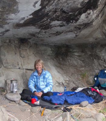
The wind was still really strong so we headed to Bannerman cave for some shelter, Bos and I were quite keen to stay at the cave, Tots had now become waterboy so he would have to walk down to fetch a backpack full of water! Two Basothos then came to the cave and just sat there for a while with their dogs, the young boy then went off with the dogs because they kept barking at us, next thing we heard the boy shouting and the other Basotho then ran off towards him, 5 minutes later they came walking past with a rabbit on a stick. Quite happy with their catch they greeted us as they walked off over the valley.
At this stage the wind had started to die down so we headed down to the river to camp. The German couple had set up camp in the cave I mentioned in the Bannerman Cave thread, the guy darted out the cave towards us and chatted for a while, only afterwards we realised that his girlfriend/wife was swimming in the river and he didn't want us heading towards her.
We found a nice spot next to a pool on the river, had a cold dip and enjoyed the good weather that night.
Langies campsite
Monday turned out to be misty, rainy and uneventful apart from the odd slip on the mud going down Langies ridge, we made decent time to get to the car from the top of Langies in 3 hours so we could get into dry clothes!
All in all a good weekend in the mountains with some lessons learnt about sticking together, especially when not following a known path!
Total distance: 44.6km
Total altitude gain: 2.3km
Please login or register to view the images attached to this post.
Please Log in or Create an account to join the conversation.
- Smurfatefrog
-
Topic Author
- Offline
- Moderator
-
- Posts: 1131
- Thank you received: 1544
Smurfatefrog wrote: This was our first attempt at Popple and we made it

Please Log in or Create an account to join the conversation.

") Little dehydrated beer sachets
Little dehydrated beer sachets Please Log in or Create an account to join the conversation.
Stats added to above post
ah damn, thanks for trying thoughSabine wrote: We dropped those beers off at 11am already, stuck them into the rocks on the left of the top of the pass. Guess someone must have seen us....

Please Log in or Create an account to join the conversation.
- Smurfatefrog
-
Topic Author
- Offline
- Moderator
-
- Posts: 1131
- Thank you received: 1544
Hi. Do you have maybe the gps coordinates for the campsite next to the rocks? It looks flatish and a bit protected from the wind due to the rocks?We headed north from the Corner and got some amazing views towards Cathkin.
Trojan Wall
The Smurf
We also had a quick browse for Intrepid & co down below Hilton Pass somewhere, but no tents to be seen!
We woke up Sunday morning to strong winds pounding our tents, we didn't even try cooking, just packed up and headed up Popple Peak.
Our rockwall shelter with Popple behind
This was our first attempt at Popple and we made it
It was almost impossible to stand still on top, its the strongest wind I've ever encountered.
Jon celebrating
The views were definitely worth it though!
Next stop, top of Bannerman Pass... Tots decided he would head down lower while the 3 of us tried to stay above 3100m.
There he goes...
After not seeing Tots for about 30 minutes we started to get a little worried, he did not have a GPS but did know where the pass was from Popple, we just hoped the mist would stay away. We went back into the valley leading off Popple and down to the river, searched, shouted, no sign of Tots! If he had gone up to the top of Bannerman Pass surely we would've seen him? Next plan was to walk to the escarpment and get cell reception, maybe he had tried to call... one last look up to the pass and there he was on a hill shouting & waving his arms! Jon & I waved back & shouted for him to stay exactly there, he then disappeared, we assumed he had sat down. To speed up things we headed straight up the hill towards him, we get to the top, he wasn't there! Jon then headed towards the top of the pass and saw 3 hikers heading away from the pass, he went towards them and who was there.. Tots! He hadn't seen us down by the river when he was up top, had somehow assumed we had taken another route to Langies and was going to head off with a German couple who were also on their way to Langies, if Jon got there 2 minutes later we wouldn't have found him! We had a short rest with plenty cows, horses, dogs & herdsman around before setting off up the Senqebethu ridge.
Bannerman Hut way down below
The wind was still really strong so we headed to Bannerman cave for some shelter, Bos and I were quite keen to stay at the cave, Tots had now become waterboy so he would have to walk down to fetch a backpack full of water! Two Basothos then came to the cave and just sat there for a while with their dogs, the young boy then went off with the dogs because they kept barking at us, next thing we heard the boy shouting and the other Basotho then ran off towards him, 5 minutes later they came walking past with a rabbit on a stick. Quite happy with their catch they greeted us as they walked off over the valley.
At this stage the wind had started to die down so we headed down to the river to camp. The German couple had set up camp in the cave I mentioned in the Bannerman Cave thread, the guy darted out the cave towards us and chatted for a while, only afterwards we realised that his girlfriend/wife was swimming in the river and he didn't want us heading towards her.
We found a nice spot next to a pool on the river, had a cold dip and enjoyed the good weather that night.
Langies campsite
Monday turned out to be misty, rainy and uneventful apart from the odd slip on the mud going down Langies ridge, we made decent time to get to the car from the top of Langies in 3 hours so we could get into dry clothes!
All in all a good weekend in the mountains with some lessons learnt about sticking together, especially when not following a known path!
Total distance: 44.6km
Total altitude gain: 2.3km
Cheers, Edwin.
Please Log in or Create an account to join the conversation.

29°13'03.95"S 29°24'21.99"E
3090m
Please Log in or Create an account to join the conversation.
- Smurfatefrog
-
Topic Author
- Offline
- Moderator
-
- Posts: 1131
- Thank you received: 1544
Hi. Thx. Yes, it is the trail going down Judges pass used by smugglers. Will add it to my gps in case need it.Sure, its very obvious if it's clear. This is the spot mentioned to you previously which has a path going near it, which is used by smugglers, they are however not a major threat (just don't leave anything outside tents)
29°13'03.95"S 29°24'21.99"E
3090m
Please Log in or Create an account to join the conversation.
