
Mafadi Winter Hike Report
The Plan:
Leave Nelspruit after work on the evening of Thursday 21st of July and head off to a guesthouse in Newcastle. An early departure the next morning in order to be at the KZN Injisuthi office by 08H00 to check in and start trekking.
Day One (Approximately 10km) on the trail would be from Injisuthi Camp, in the direction of Centenary Hut, along the less travelled boundary road.
Day Two (Approximately 16km) would be an early start to ascend the escarpment using the Northern High Approach into Corner Pass. Make it to the upper Injisuthi Cave by nightfall.
Day Three (Approximately 14km) would be out and up Injasuthi en route to the top of Mafadi. Once completed we would trek north for the descent using Leslies Pass. Once down, we would make camp at either the bottom pass camp or onto Marble Baths Cave.
Day Four (Approximately 7km) Sunday would be used to exit the valley back to Injisuthi Camp. Sign out of the Mountain Register and drive home to Nelspruit!
Simple?..........Not

Actual Trip report:
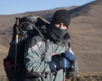
DAY ONE 22nd July 2016
Starting out from the camp, we were at the bridge by 09H00. Not going up the valley along the river but assaulting an intimidating 500m climb using old ladders and chains to get to the top of the iNtanahlana Ridge, past the old field rangers hut. Once up, we made good progress. Spotting our first Eland herd, Rhebok, Cape Vulture and the Bearded Vulture. All a privilege to see in their natural winter habitat. We reached our overnight spot in the early afternoon, made camp under a small overhang near a flowing stream. Perfect
.
DAY TWO 23rd July 2016
After a good night’s rest we started on our way towards Centenary Hut, a landmark to start our actual ascent. The weather remained fair, except for a predicted wind, which began gusting around midday. We made good time on the steep Northern High Approach to Corner Pass. The wind and winter sun had us using our water supply rather faster than we had intended. We knew of possible water in the Corner pass we would have to push on and up. We found the stream and its little waterfall, however, the recent cold temperatures had frozen the small waterfall in an almost magical still-life of stalactites and stalagmites.
We managed to fill our water bottles with pure ice to melt later and drink. We made slow progress, and after almost 3 hours in the pass we popped out on the top of Corner pass just before dusk. Realising we would not make the Upper Injisuthi cave, we opted to find water and a small hill to shield us from the chilling wind. We set up our tents and prepared for the night. This was the coldest night measuring, - 5˚C at midnight.
DAY THREE 24th July 2016[/b]
We broke camp after having to take time to melt iced water (river just down from Corner pass) for breakfast and the rest of the day. We were off, heading for Injisuthi Peak and onto Mafadi. The wind had picked up and was now gusting at between 40 and 50km per hour. This slowed our progress and made trekking tough. Although there was water in almost every stream, the rivers had all been frozen solid and made irresistible photography opportunities.
There was left over snow on and around both peaks, although not recent, the sub-zero temperatures had preserved it even against the winter sun.
We peaked Mafadi, our goal, at midday on Day three. A fantastic sense of achievement and in constant admiration for the solitude of the vast expanse of the mighty Drakensberg.
Thanx to VE and JonWells we were aware of bad weather arriving the following day, and as much as we wanted to stay and soak up the moment we had to push north to find our exit pass.
We arrived at the top of Leslies Pass at 14H00. This caused a debate, as to whether we should start the descent or camp and start in the morning. We knew we had 3 hours of good light, and, based on the fact that bad weather was imminent, we pushed downhill. Our progress was slow as we were now at the end of a very long day. We finished the last few hundred meters to the camp with our headlamps on and a few stumbles and grumbles.
By 19H00 we had pitched camp, in noticeably warmer temperatures, 2˚C or 3˚C. After a warm meal we headed for our tents, commenting on our fantastic achievement for the day, and now all we needed was snow!
DAY FOUR 25th July 2015
At four in the morning Vincent woke us by screaming from his tent “SNOW” personally I thought he was joking and rolled over for my last bit of sleep.
At six we awoke to a white fairy land. Snow had fallen through the night and proved to be the cherry on the cake. Truly unbelievable, and sobering at the same time.
Had we not taken heed of the weather and stayed on top the day before we would have been in some serious trouble.
We started our trek back to camp, this was complicated as the paths were covered by the snow. With the help of a few cairns and a few wrong turns we plodded back to camp to report at the office and sign out of the mountain register.
The relief on the camp manager’s face on our return was further evidence that we had literally just made it off and out in time. A warm shower and clean clothes, we left Injisuthi Camp looking for steak, egg and chips before the homeward journey back to the warm Lowveld.
A special thanx to JonWells, Diverian for the valuable information
 , and to Riaang for the perfect NHA track (followed to the T), as well as every hiker who ever placed a stone on a cairn from the bottom of Leslie's pass to Injisuthi camp, in the snow they were invaluable.
")
Photo credits to Heinrich. I will post more pics in the Gallery section.
“You need special shoes for hiking — and a bit of a special soul as well.”
Terri Guillemets
Please login or register to view the images attached to this post.
Please Log in or Create an account to join the conversation.
Any chance you have more details and photos on Boundary Ridge? It is on my to-do list, but I know very little about it.
Funny enough, cairns are a violation of the World Heritage Site rules, and there are various people who actually make a point at destroying cairns. Personally I rate this is uncalled for, piles of rocks do occur naturally anyway - but some are arb or even misleading and do warrant destruction.Redshift3 wrote: A special thanx ... every hiker who ever placed a stone on a cairn from the bottom of Leslie's pass to Injisuthi camp, in the snow they were invaluable.
Please Log in or Create an account to join the conversation.
 Sounds like a mission that was well worth it.
 Please Log in or Create an account to join the conversation.
Please Log in or Create an account to join the conversation.

So how did you find the NHA? I see you guys didn't do the around the corner variation, you should try it out next time (in dry weather), it is a nice route although with a bit of exposure.
I'd defintely want to know more about your day 1 route, that climb looks like a lot of fun. Please PM me your tracks.
Please Log in or Create an account to join the conversation.

I'll put a picture of my map with the route drawn in if I get a chance. But basically from injisuthi camp you cross over the road bridge and begin on the path that leads to poachers stream. Roughly 500m (once you have gotton on top of the first little ridge) you come across a path that heads off at 90 degrees directly upwards towards the cliffs. This path eventually leads to a break in the cliff face which is where the old ladder and chain shown in redshift3's picture is. Soon after, the path ends at the field rangers outpost. From there you just follow the jeep track past cloudless collonial. The path leading off to Centenary hut starts directly from the jeep track and is rather obviously (and marked by a small cairn). From here it's about 1.5km to centenary hut.
There is also a shortcut where you leave the jeep track and rejoin it at the same point that the path that leads to centenary hut starts. If you don't know where this is its probably easier to just follow the jeep track as standard and forget about the shortcut.
Please Log in or Create an account to join the conversation.
- john mark 1
-

- Offline
- Elite Member
-

- Posts: 125
- Thank you received: 23
In my opinion if you pressed for time then the jeep track is the fastest way to Centenary Hut. There is a "heartbreak hill" at the beginning, just over the river, however once done its all good on top. The downside this time around was winter. Once on top the terrain can be pretty barren. This winter was worse as there had been some "burning" looked controlled? Never the less when the wind howls over the burnt plains you end up looking like a chimney sweep.
Upside you almost guaranteed Eland and Rhebuck and navigation is straight forward.
“You need special shoes for hiking — and a bit of a special soul as well.”
Terri Guillemets
Please Log in or Create an account to join the conversation.
Damn the wind nearly blew us off the NHA! I really liked this option, the scramble was tougher than I had imagined and required us to take packs off and use a rope to pull them up.
I also thought that we would drop into the actual pass a lot closer to the top.
All said and done I still think its a better option than all the way
“You need special shoes for hiking — and a bit of a special soul as well.”
Terri Guillemets
Please Log in or Create an account to join the conversation.
2 years ago we wanted to get on top of that hill with the ranger hut, and we pretty much got to the point where the track then goes back towards the road. We thought this would take us back to the road so opted to bundu bash our way up that hill. Carried on about 1km or so to the right and then simply climbed up at the first hill on the left that didn't have a rock band at the top. Was quite tiring as we basically climbed very steep terrain (we had to climb sideays as in places it was so steep I couldn't lift my legs forward :-0.
Thanks for clearing up where the route actually goes. We got onto the jeep track about 1km southwards from the guard hut and then just followed it for a while, turned off towards the hut and got to Centenary hut in no time. The benefit of this route is that you climb the steep part early in your hike, whereas heartbreakhill is later on when you are (possibly) more tired.
Please Log in or Create an account to join the conversation.
I had also wanted to take that route a few years back, I seem to recall a vote of 4 against 1 when we got to the split. That was Riaang, Fitness, ASL and Bugs vs GhazRiaang wrote: 2 years ago we wanted to get on top of that hill with the ranger hut

Please Log in or Create an account to join the conversation.
