
- Forum
- Drakensberg Forum
- Drakensberg Trips
- Vergelegen
- Mohlesi/Ngaqamadolo South Pass: a tale of fire and
Mohlesi/Ngaqamadolo South Pass: a tale of fire and
After a 5 week break – my longest stretch of not hiking in about a year, myself and Hobbit were off to Vergelegen for another overly optimistic 2 dayer with a headstart. We always try to finish on Sunday before the time we started on Friday, thus keeping our time below 48 hours and making our claim to it as a 2 day hike valid.
So, after my meeting had overrun, and Mike’s lift home from school never showed up, we found ourselves about an hour behind schedule, only leaving Hilton at 2PM on Friday. This was followed by the roadworks on the Stepmore Road being in particularly bad shape for about 5km – perhaps this road should be avoided by smaller vehicles for the moment. But what took the cake was the Vergelegen Road – I had said before that any careful driver can drive this, and perhaps it is true, but the 7km stretch from the EKZN Gate to the offices very easily could have damaged my car, and it took over an hour to drive from the turnoff to the offices. So after taking 3 hours to drive 135km, we were finally at Vergelegen, and it was already getting dark.
We handed in our pre-completed mountain register entry and soon we were off, around 5:15PM.
What can I say about the walk-in to Birds Nest Cave – rivers are just low enough to cross with shoes on (always fun in the dark), and lots of burned grass. We found the cave with no difficulties, and settled in for an early night.
At 5AM, with the moon shining brightly, I woke Mike and we decided to set off early. As when I did Nhlangeni Pass in February, we managed to follow the trail for a bit, and soon it was gone. This time the riverbed was the route of choice.
The walkin up the Nhlangeni Valley is slow and long, and it seemed to take an age to reach the Nhlangeni/Mohlesi Split.
Mohlesi Pass has been a bit of a mystery pass to me. David Bristow’s book claims that it is not actually a pass, but rather a technical route – the map calls it a rock pass and says it may require ropes. On GT last year, Mike and I had traversed into the top of the gully as a variation route, and I had had a look up it when I did Nglangeni Pass earlier this year. Visually it seemed to lack the gremlins that the map and Best Walks of the Drakensberg suggested.
By this point, I was thinking that the goal of Giants Castle had already begun to slip – 43km days are always tough, especially when you chose a pass like Mohlesi Pass!
The lower section of the pass is just a standard rocky riverbed, or wide grassy sides – nothing difficult. When you actually hit the gully, there is a waterfall that looks easy to scramble, but seeing as it was frozen solid – we opted to skip it by the steep grassy ledge to the right (true left).
Above the lower waterfall we resumed our use of the gully. This was cut short when we hit a large chock-stone in the gully. We took a steep climb out of the gully from here – taking the true right slopes this time, this had always been the plan to bypass the upper waterfalls (the true left side is almost entirely cliffs above this point).
We found a variation gully that looks pretty simple – I have assigned it a project name of “You Shall Not” Pass (don’t worry, if I head up it and it goes, I will come up with a better name).
We continued up the grassy slope, my GPS confirmed that the gradient was pretty consistent at just steeper than 1m vertical for 2m flat. There was a side gully with sheer cliffs that cut through our grass slopes – this was the only significant obstacle on the pass. We had to climb above the cliffs to get past, Mike took a very exposed steep grass ledge, and I opted to climb a small cliff to get above it, resulting in a much safer traverse. My route required 2 easy technical moves on solid holds (maybe D grade at most) – not exposed and I didn’t even need to take my pack off. I guess one could argue that it should get rock status for this bit, but seeing as it was probably possible to get above this by climbing higher on the bank earlier on, and Mike’s route require no technical moves – I don’t rate this enough to classify it as a rock pass.
From there to 3000m it remained pretty universal. When the gully narrows, there is a very easy to walk straight into the gully. The last 150m vertical is a simple grassy gully – although it had quite a bit of snow in it.
We only got to the top around 12:30 – we had drastically underestimated how slow the pass would be. Mike rated it a 7/10 and I had it as a hard 6/10 – nonetheless we agreed that it is not a rock pass. There was no summit cairn, and no signs of use. I have no difficulty in believing that this pass gets no more than a use or two every decade. It is actually quite a fun pass, but 22km from the car park, with over 1.8km in altitude gain from the car park, and in an area that few people venture to visit – I am not surprised that a pass classified as rock and “may require ropes” gets very little attention.
We had lunch at the top of the pass, with no shortage of snow in sight. It had been a slog fro Birds Nest Cave, but I was happy to find that my judgement had been correct – pretty much stay on the left (true right) and the pass would be a standard grassy ledge route.
We proceeded to bag Mohlesi – we had both bagged it before, but the last time we had taken our summit shots away from the top due to a large group of people with big white bags, after they had sent a group member to herd us out of their way. Memories of him saying something like “the route goes up here, you are going the wrong way”. We had known that our Mokhotlong traverse had gone out the window already, so we headed down to the frozen river to chill.
The ice must have been at least 10cm thick. We built a large cairn on top of it, which did not even crack it.
Eventually we headed up to Sehonghong Cave (at the top of Nglangeni Pass, not the shelter further down the valley), where we spent the night. The snow on the south facing slopes of Mohlesi was spectacular by moonlight!
At 5:30AM we were off again. We shot down to the river first to fill up our bottles, before starting the slog up Thabana Ntlenyana. We summited the second peak just before the sun came up, and had a breakfast break in the saddle between the second summit and the main summit. We proceeded to bag the main peak and the third peak. Time was becoming a problem, and we had a bit of a shock when my GPS told me that we had 32km left. I soon realised that the GPS track for the pass needed to be reversed, but the 20+km distance remaining meant that we would be in for a late finish.
We decided to bag Thaba Putsoa – which is a slog of note, but has an incredible view. We spent a while figuring out what we were looking at, but I am reasonably certain we were able to see Icidi Buttress! There was snow all over Lesotho, deep valleys as far as the eye can see, and the watercourse of the Mokhotlong, Senqu and Kubedu Rivers were all very clear.
We decided to take as direct a route to Ngaqamadolo Pass as possible, the GPS showing it as 9.6km away as the crow flies. We used our altitude very effectively, traversing around 2 riverbeds before dropping to the Mohlesi River.
Ngaqamadolo itself was always going to be a big obstacle, but we knew we would need climb to get around it, so we began to climb as soon as we reached it. We met a friendly shepherd watching his sheep, and after a brief chat we were off again.
Ngaqamadolo actually passed by really quickly – when you go into a ridge like that knowing that you will need to climb, you make your route planning much easier.
We had to drop some altitude on the other side, especially knowing there would be no water on the pass, or possibly even before the car park. We had lunch on the river between Ntsupenyana and Mlahangubo about 300m from the SA border. The river was surprisingly full for this time of the year and so close to the watershed.
We traversed though North Ngaqamadolo Pass, which looks quite steep, and soon found ourselves in the South Ngaqamadolo Pass gully. It had been burned the day before – the smoke cloud had been clearly visible from various spots.
There is a cave near the top, it has a high roof, but could easily sleep 12. There was no rock wall in front of it, and it was full of freshly burned grass tufts – this cave clearly isn’t used much, and probably not for a few years.
The trail on the pass alternated between very clear and non-existent. The gradient is reasonably steep, with the pass traversing out of the main gully very high up, and using a grassy side gully from there.
We bumped into a group of 4 Basothos with lots of dogs. With the large fire the day before, and 4 of them compared to only 2 of us – we were a bit nervous, but we did the waving and shouting “hello” from 100m away routing. Had a friendly chat with them and they left us alone. One of their dogs was struggling behind, it kindly posed for some photos. We made sure we didn’t give the dog any attention – we didn’t want it following us down the pass.
The pass bottoms out quite high. The map shows the trail going along the top of the ridge in a reasonably straight line right back to the car park. The direction on the map is correct, but the trail alternates between very clear and non-existant.
With the aid of a berg.co.za GPS track, we managed to find our way along the ridge. There was only one spot with water, a small stream, and there was a lot of up and down.
With my GPS saying we had 3km to go, but still needed to drop 700m in altitude. My guess that a small Berg pass was coming proved to be correct. The trail was very clear through the main top section of the pass, but then disappeared through the lower section. We could see the car park from here, so we followed trails as we could, leaving them when they went in the wrong direction (the clearest trail appears to go nowhere near the car park). Once we had down-climbed some scrambles, we found a good trail that lead us back to the car park.
At 4:30PM (47h15) we had completed our 60km loop.
People often say that Mnweni is the most rugged and untouched part of the Berg. I rate that people only say this because they never hike at Vergelegen. It has a lot in common with Mnweni – a low car park and long walk-ins. In isolation, the passes are easier than Mnweni (well, out of the 4 I have done at Vergelegen and 6 at Mnweni), but Mnweni has a much better network of trails.
We both agreed that South Ngaqamadolo Pass is about a 4/10, and at 12km from the car park, it is probably the easiest route to the top from Vergelegen. The hill behind the offices must be seriously demotivating, though!
Please Log in or Create an account to join the conversation.

Please login or register to view the images attached to this post.
Please Log in or Create an account to join the conversation.
Please login or register to view the images attached to this post.
Please Log in or Create an account to join the conversation.
Please login or register to view the images attached to this post.
Please Log in or Create an account to join the conversation.
Please login or register to view the images attached to this post.
Please Log in or Create an account to join the conversation.
Please login or register to view the images attached to this post.
Please Log in or Create an account to join the conversation.
Please login or register to view the images attached to this post.
Please Log in or Create an account to join the conversation.
- It is an ultra-prominence peak, the only one in the Drakensberg
- It is the 11th most isolated peak on earth
- It is the 171st most prominent peak on earth
- It is the 54th country high point
- It is the highest point in the 19th largest drainage basin on earth
Please Log in or Create an account to join the conversation.
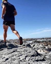
EDIT: I'm not implying you take bad photos BTW... Also, in the one photo it looks like that one gentlemen is not wearing any long pants, is that correct? It must be ice cold!
Please Log in or Create an account to join the conversation.
While that sounds fun, my entire hiking model right now revolves around not carrying, well, anything. With long days, I also rarely have the time to plan a shot, change settings etc. Sunday was a 35km day with 935m in gain and 2631m in altitude loss - with a 5:30AM start. It is funny - I used to wonder how people could start hiking while it is dark and spend the entire day out, now I wonder how many sunrises I could have seen if I wasn't in my tent, and how much ground I could have covered if I was simply fit enough to keep going all day.AdrianT wrote: You should really get a DSLR and start taking photos with it. It is worth the extra weight, plus you'll appreciate the extra pain in the long run. And then of course you'd be required to write a book on the Berg, in detail.
That is correct. The Basotho people up there must be some of the toughest people around. Admittedly it was quite warm when that photo was taken, possibly even above 10C - Mike and I were both down to a single layer of clothing.AdrianT wrote: Also, in the one photo it looks like that one gentlemen is not wearing any long pants, is that correct? It must be ice cold!
On a side note - here's our GPS track for Sunday, you will notice that our line from Thaba Putsoa is actually quite straight!
Our stats for the weekend as per my GPS track:
Distance: 59km
Average moving pace: 3.58km/h
Lowest altitude: 1373m
Highest altitude: 3485m (3m out from the survey height of Thabana Ntlenyana)
Total altitude gain: 3137m
Please login or register to view the image attached to this post.
Please Log in or Create an account to join the conversation.
