
The Evranda Rock Bridge - Vergelegen
09 Aug 2016 16:49 - 09 Aug 2016 16:51 #69425
by elinda
The Evranda Rock Bridge - Vergelegen was created by elinda
I heard about the Evranda Rock Arch several years ago and it has been on my ‘to do ‘ list for some time. Last weekend Richard and I spent three days at Vergelegen and I got to see this amazing rock formation.
Day one - We set off on Saturday morning and headed off towards “The Hook” which is on the Northern/Lotheni side. The escarpment was still full of snow right down to contour path level and looked spectacular! The plan was to walk along the ridge and back towards Mlahlangubo Pass where we would tent the first night. This was unknown territory and we relied on the map…as has been experienced before by others on this forum, most paths that are marked on the Vergelegen map are to be used as a guide only - the paths marked are not exactly where they are shown and we found ourselves doing a lot of self navigation.
We unfortunately never got to the top of the ridge as the path faded quite badly and we were in doubt whether to continue upwards - to confuse matters more we noticed a strong path a bit below which we assumed would climb up to the ridge a bit further on. So we took the lower path which continued on the right hand side of the valley ( true left) for a long time, and crossing numerous side gullies. It never did get on to the ridge so we resigned ourselves to walking up the valley.
Towards lunchtime we went down to the river with the intention to walk on the path that we could now see on the other side as it looked a lot easier. As we were having lunch we heard dogs barking and looked up to the path to see 5 Basutes ( one with a panga in full view) walking by with no less than 15 dogs in tow. This was clearly a hunting party that had come down Mlahlangubo Pass. It was shocking to see and they did not appear worried that we had seen them - in fact they waved and were very friendly. They continued on their way and we carried on hiking up the valley - we thought that once they had got what they came for they would go back up the pass and we wanted to be camped and out of sight. It was a long trudge for me as my energy levels were low - this sometimes happens on the first day of a hike so I was glad once we reached a suitable camp spot in the side tributary of the Mhlalangubo Omkhulu. The hunting party returned up the valley at 4.00pm - they were heavily laden and had obviously made a kill. We did not see them going up the pass and on investigation saw that they had stopped on the other side of a large hill and were re-packing the meat. Richard walked up the hill and observed that it must have been an Eland they had taken as he clearly saw an Eland tail. The dogs saw Richard and barked, but again the poachers did not seem at all worried. They made a fire in the river bed and eventually left to go up the pass as dusk was falling. We could not believe that this was so brazen and wondered just how much of this was going on.
Day 2
The wind had got up during the night and we packed up in cold blustery conditions - this made for beautiful cloud formations but not great hiking weather. Looking at the map we thought we had about 8 or 9 kms to go to the Evranda Rock Arch so thought we were in for an easyish day. But we did not account for the numerous gullies and ridges along the way - its pretty rough country and the map does not show this! As we came into the valley with the Ngaqamadola Passes we walked under Mhlalangubo peak and noted people on the top - we are certain that these were the very same Basutes we had seen the day before that were looking down and checking out the terrain for another hunting expedition later that day. They noticed us looking up at them and again made themselves quite known and waved and shouted. Both Mhlalangubo Pass and both variations of Ngaqamadola ( North and South) look very doable and we will return some time to do them.
We crossed over into the huge valley that the Saddle presides over and again were confronted with many ridges and gullies to get through before we got to the bridge. Approaching from the North the rock bridge is not readily visible as you see it from the side, and it is only as you are directly underneath it that you can see this massive feature.
I had not expected it to be so high up from the contour path and its definitely quite a bit of PT to get there! As it is so high up against the escarpment its just in the snowline so the last hundred metres or so were pretty slippery. It is a very impressive sight and reminded me a bit of the Wolfberg Rock Arch in the Cederberg. Well worth the effort of the day!
( We never did get to see the smaller Rock Arch that is on the latest map - does anyone have a photo of it?) We found a level camp spot a bit further down that afforded a lovely view of the rock bridge and was also next to a small stream that was running due to the recent snows. The wind continued to blow and in fact seemed all the stronger in this valley and we settled in for the night.
Day 3
We packed up and were on our way by 8.00am. We decided to take the long ridge that runs down from C16 on the map and make our way down the Mkhomazi Pass valley and then go up and over the ridge down to Birds Nest Cave. This ridge had been extensively burnt so the path that appears as “ ill defined’ on the map was relatively easy to follow.
We go up on to the ridge and it was whilst up there that our attention was once again attracted by the barking of dogs. To our dismay we saw yet another pack of hunting dogs that were in full cry across the valley from us. We had a birds eye view being so high up and saw that there were two groups - one of 8 dogs that were chasing an Eland from high up on the opposite ridge and another smaller pack of 4 dogs that were chasing another Eland. We watched the pack of 8 running with the Eland all the way down to the bottom - the Eland was tiring rapidly and after passing out of our sight, it was a few minutes before we heard a loud sickening thump from below. The owners of the dogs had seen us and recalled the dogs but had hidden themselves well as we never saw them. All the dogs eventually made their way back up the ridge ,presumably back to their owners and down to the next valley. We think the thump that we heard was the sound of the Eland being driven into a very deep ravine that we could see from our vantage point.
We went down to Birds Nest Cave and then hiked back to the office. We reported all that we had seen to the Chief Ranger there and also showed him photos that we had taken. He said that they are aware of the poaching but despite requests to Head Office have not been sent the extra man power they need to combat this worrying situation. As this is a remote area not often visited by hikers this is an open invitation for poachers and if this situation is allowed to continue the Eland population will disappear. Richard is putting together a report for the powers that be and we really hope that they will do something about this sad situation.
Day one - We set off on Saturday morning and headed off towards “The Hook” which is on the Northern/Lotheni side. The escarpment was still full of snow right down to contour path level and looked spectacular! The plan was to walk along the ridge and back towards Mlahlangubo Pass where we would tent the first night. This was unknown territory and we relied on the map…as has been experienced before by others on this forum, most paths that are marked on the Vergelegen map are to be used as a guide only - the paths marked are not exactly where they are shown and we found ourselves doing a lot of self navigation.
We unfortunately never got to the top of the ridge as the path faded quite badly and we were in doubt whether to continue upwards - to confuse matters more we noticed a strong path a bit below which we assumed would climb up to the ridge a bit further on. So we took the lower path which continued on the right hand side of the valley ( true left) for a long time, and crossing numerous side gullies. It never did get on to the ridge so we resigned ourselves to walking up the valley.
Towards lunchtime we went down to the river with the intention to walk on the path that we could now see on the other side as it looked a lot easier. As we were having lunch we heard dogs barking and looked up to the path to see 5 Basutes ( one with a panga in full view) walking by with no less than 15 dogs in tow. This was clearly a hunting party that had come down Mlahlangubo Pass. It was shocking to see and they did not appear worried that we had seen them - in fact they waved and were very friendly. They continued on their way and we carried on hiking up the valley - we thought that once they had got what they came for they would go back up the pass and we wanted to be camped and out of sight. It was a long trudge for me as my energy levels were low - this sometimes happens on the first day of a hike so I was glad once we reached a suitable camp spot in the side tributary of the Mhlalangubo Omkhulu. The hunting party returned up the valley at 4.00pm - they were heavily laden and had obviously made a kill. We did not see them going up the pass and on investigation saw that they had stopped on the other side of a large hill and were re-packing the meat. Richard walked up the hill and observed that it must have been an Eland they had taken as he clearly saw an Eland tail. The dogs saw Richard and barked, but again the poachers did not seem at all worried. They made a fire in the river bed and eventually left to go up the pass as dusk was falling. We could not believe that this was so brazen and wondered just how much of this was going on.
Day 2
The wind had got up during the night and we packed up in cold blustery conditions - this made for beautiful cloud formations but not great hiking weather. Looking at the map we thought we had about 8 or 9 kms to go to the Evranda Rock Arch so thought we were in for an easyish day. But we did not account for the numerous gullies and ridges along the way - its pretty rough country and the map does not show this! As we came into the valley with the Ngaqamadola Passes we walked under Mhlalangubo peak and noted people on the top - we are certain that these were the very same Basutes we had seen the day before that were looking down and checking out the terrain for another hunting expedition later that day. They noticed us looking up at them and again made themselves quite known and waved and shouted. Both Mhlalangubo Pass and both variations of Ngaqamadola ( North and South) look very doable and we will return some time to do them.
We crossed over into the huge valley that the Saddle presides over and again were confronted with many ridges and gullies to get through before we got to the bridge. Approaching from the North the rock bridge is not readily visible as you see it from the side, and it is only as you are directly underneath it that you can see this massive feature.
I had not expected it to be so high up from the contour path and its definitely quite a bit of PT to get there! As it is so high up against the escarpment its just in the snowline so the last hundred metres or so were pretty slippery. It is a very impressive sight and reminded me a bit of the Wolfberg Rock Arch in the Cederberg. Well worth the effort of the day!
( We never did get to see the smaller Rock Arch that is on the latest map - does anyone have a photo of it?) We found a level camp spot a bit further down that afforded a lovely view of the rock bridge and was also next to a small stream that was running due to the recent snows. The wind continued to blow and in fact seemed all the stronger in this valley and we settled in for the night.
Day 3
We packed up and were on our way by 8.00am. We decided to take the long ridge that runs down from C16 on the map and make our way down the Mkhomazi Pass valley and then go up and over the ridge down to Birds Nest Cave. This ridge had been extensively burnt so the path that appears as “ ill defined’ on the map was relatively easy to follow.
We go up on to the ridge and it was whilst up there that our attention was once again attracted by the barking of dogs. To our dismay we saw yet another pack of hunting dogs that were in full cry across the valley from us. We had a birds eye view being so high up and saw that there were two groups - one of 8 dogs that were chasing an Eland from high up on the opposite ridge and another smaller pack of 4 dogs that were chasing another Eland. We watched the pack of 8 running with the Eland all the way down to the bottom - the Eland was tiring rapidly and after passing out of our sight, it was a few minutes before we heard a loud sickening thump from below. The owners of the dogs had seen us and recalled the dogs but had hidden themselves well as we never saw them. All the dogs eventually made their way back up the ridge ,presumably back to their owners and down to the next valley. We think the thump that we heard was the sound of the Eland being driven into a very deep ravine that we could see from our vantage point.
We went down to Birds Nest Cave and then hiked back to the office. We reported all that we had seen to the Chief Ranger there and also showed him photos that we had taken. He said that they are aware of the poaching but despite requests to Head Office have not been sent the extra man power they need to combat this worrying situation. As this is a remote area not often visited by hikers this is an open invitation for poachers and if this situation is allowed to continue the Eland population will disappear. Richard is putting together a report for the powers that be and we really hope that they will do something about this sad situation.
Please login or register to view the images attached to this post.
Last edit: 09 Aug 2016 16:51 by elinda. Reason: Duplication
The following user(s) said Thank You: diverian, SeriousTribe2, ghaznavid, Smurfatefrog, AdrianT, AndrewP, Papa Dragon
Please Log in or Create an account to join the conversation.

09 Aug 2016 17:02 - 09 Aug 2016 17:04 #69426
by elinda
Replied by elinda on topic The Evranda Rock Bridge - Vergelegen
And this one just for fun! These were growing in the gully directly below the Rock Bridge and I immediately thought of "The Donald"

Please login or register to view the image attached to this post.
Last edit: 09 Aug 2016 17:04 by elinda.
Please Log in or Create an account to join the conversation.
09 Aug 2016 18:12 #69428
by Smurfatefrog
Replied by Smurfatefrog on topic The Evranda Rock Bridge - Vergelegen
Please post a couple more pics of the arch

elinda wrote: And this one just for fun! These were growing in the gully directly below the Rock Bridge and I immediately thought of "The Donald"
Please Log in or Create an account to join the conversation.
- Smurfatefrog
-

- Offline
- Moderator
-

Less
More
- Posts: 1134
- Thank you received: 1551
09 Aug 2016 18:44 #69429
by elinda
Replied by elinda on topic The Evranda Rock Bridge - Vergelegen
More photos of the Arch....... Just for you, Smurf!
Please login or register to view the images attached to this post.
The following user(s) said Thank You: Serious tribe, Stijn, JonWells, Smurfatefrog, tonymarshall, Viking, ruthtbl, AdrianT, Richard Hunt, Papa Dragon
Please Log in or Create an account to join the conversation.
03 Sep 2018 20:32 - 05 Sep 2018 13:50 #73928
by elinda
Replied by elinda on topic The Evranda Rock Bridge - Vergelegen
Return to Evranda Arch
We asked one of the rangers at Vergelegen how Evranda Arch got its name and he said that it is known as 'E Vranda because it is like a huge veranda………this was his take on it so who knows!
When we visited Evranda Arch two years ago, we noticed a steep snow filled gully to the escarpment that runs in the same direction as the Arch, a dike that looked very interesting with a possible route to the top. Single Speed (Hylton) and Papa Dragon (Roger) had also never seen the Arch, so the plans were made and we set off last weekend. We had accessed the Arch the previous time from the North,spending our first day hiking from the office to the base of Mahlangubo Pass and then traversing southwards towards the Arch on the second day. This time we decided on a different approach and climbed the Inkangala Ridge which is behind the office. This involves a steep climb to Plum Pudding and then 8km along the ridge towards the contour path. Our plan was to overnight at the Arch which we ultimately failed to achieve, mostly because of my unfitness. I took strain going up the initial climb and the ridge was definitely not flat with quite a few uphill sections along the way. We ended up tenting at the oQalweni River underneath the Ntsupenyama massif. The weather had been mild the entire day and we enjoyed a relaxed evening sitting outside our tents and chatting. We heard dogs barking and noticed the silhouette of a Basuto herdsman on the escarpment so we had clearly been spotted. We spent an uneventful night however and woke to another warm day, experiencing beautiful marbled cloud formations every day which was special to see. We set off southwards on a path that came and went, as it frequently does in Vergelegen! One does not immediately see the Arch when it is first approached as it faces Southwards towards Mkhomazi pass and it is hard to make out from the side. As we got closer we noticed a distinct cave on the side of the Arch that we had not noticed before. There are a series of steep gullies that one has to negotiate to reach it and the going is quite rough. Richard and I have of course seen it before, but it impressed us all over again. It is massive and well worth the hard work required to get there. There is a stream and small waterfall that runs through the rear of the Arch and one marvels at the sight it would be in Summer when in full spate. The stream was of course dry when we were there. I achieved my wish of walking on top of the Arch and the photo shows the size of this massive.The cave was reached easily via a steep grass slope and it would seem that it has been used before as there appears to be the remains of a rock wall in the front. It is fairly small and would sleep 4 with maybe 6 at a squeeze and a bit of housekeeping. No water in winter, and you would have to go down 200 metres or so to collect water in the various streams in the gullies below. In Summer one should be able to get water from behind the Arch itself. The cave is not marked on the Parks Board map, perhaps it should be called Evranda Cave? Does anyone have any other information on this?We had a good look at the gully to the escarpment, now without any snow, and observed that there was a scree field below which could be loose. What concerned us more though, was the top section that looked extremely steep with an unknown area at the very top that could possibly be a solid rock wall. More time is needed for further exploration.We then headed down the ridge and into the Mkhomazi Valley and ascended the pathway up and over the Ngcingweni Ridge to Birds Nest Cave where we overnighted. We walked out down the Mkhomazi River Valley, one section through a just burnt section, so we all looked like coal miners by the time we got back to the office!Thanks to Richard, Single Speed and Papa Dragon for a thoroughly enjoyable hike. The Evranda Arch is unique, possibly the Wolfberg Arch in the Cedarberg is similar in size and also immensely impressive, but I don't think there is anything similar in the Drakensberg.
Photos to follow........
We asked one of the rangers at Vergelegen how Evranda Arch got its name and he said that it is known as 'E Vranda because it is like a huge veranda………this was his take on it so who knows!
When we visited Evranda Arch two years ago, we noticed a steep snow filled gully to the escarpment that runs in the same direction as the Arch, a dike that looked very interesting with a possible route to the top. Single Speed (Hylton) and Papa Dragon (Roger) had also never seen the Arch, so the plans were made and we set off last weekend. We had accessed the Arch the previous time from the North,spending our first day hiking from the office to the base of Mahlangubo Pass and then traversing southwards towards the Arch on the second day. This time we decided on a different approach and climbed the Inkangala Ridge which is behind the office. This involves a steep climb to Plum Pudding and then 8km along the ridge towards the contour path. Our plan was to overnight at the Arch which we ultimately failed to achieve, mostly because of my unfitness. I took strain going up the initial climb and the ridge was definitely not flat with quite a few uphill sections along the way. We ended up tenting at the oQalweni River underneath the Ntsupenyama massif. The weather had been mild the entire day and we enjoyed a relaxed evening sitting outside our tents and chatting. We heard dogs barking and noticed the silhouette of a Basuto herdsman on the escarpment so we had clearly been spotted. We spent an uneventful night however and woke to another warm day, experiencing beautiful marbled cloud formations every day which was special to see. We set off southwards on a path that came and went, as it frequently does in Vergelegen! One does not immediately see the Arch when it is first approached as it faces Southwards towards Mkhomazi pass and it is hard to make out from the side. As we got closer we noticed a distinct cave on the side of the Arch that we had not noticed before. There are a series of steep gullies that one has to negotiate to reach it and the going is quite rough. Richard and I have of course seen it before, but it impressed us all over again. It is massive and well worth the hard work required to get there. There is a stream and small waterfall that runs through the rear of the Arch and one marvels at the sight it would be in Summer when in full spate. The stream was of course dry when we were there. I achieved my wish of walking on top of the Arch and the photo shows the size of this massive.The cave was reached easily via a steep grass slope and it would seem that it has been used before as there appears to be the remains of a rock wall in the front. It is fairly small and would sleep 4 with maybe 6 at a squeeze and a bit of housekeeping. No water in winter, and you would have to go down 200 metres or so to collect water in the various streams in the gullies below. In Summer one should be able to get water from behind the Arch itself. The cave is not marked on the Parks Board map, perhaps it should be called Evranda Cave? Does anyone have any other information on this?We had a good look at the gully to the escarpment, now without any snow, and observed that there was a scree field below which could be loose. What concerned us more though, was the top section that looked extremely steep with an unknown area at the very top that could possibly be a solid rock wall. More time is needed for further exploration.We then headed down the ridge and into the Mkhomazi Valley and ascended the pathway up and over the Ngcingweni Ridge to Birds Nest Cave where we overnighted. We walked out down the Mkhomazi River Valley, one section through a just burnt section, so we all looked like coal miners by the time we got back to the office!Thanks to Richard, Single Speed and Papa Dragon for a thoroughly enjoyable hike. The Evranda Arch is unique, possibly the Wolfberg Arch in the Cedarberg is similar in size and also immensely impressive, but I don't think there is anything similar in the Drakensberg.
Photos to follow........
Last edit: 05 Sep 2018 13:50 by elinda.
Please Log in or Create an account to join the conversation.
03 Sep 2018 20:40 #73929
by elinda
Plum Pudding in the background
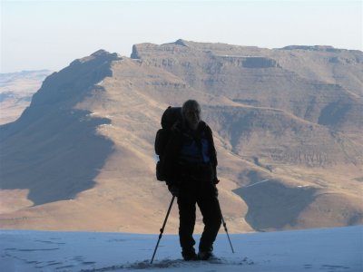
Climbing up to Plum Pudding and the Inkangala Ridge
Contemplating the beginning of our Ridge walk
Tenting underneath Nsupenyama
Replied by elinda on topic The Evranda Rock Bridge - Vergelegen
Plum Pudding in the background
Climbing up to Plum Pudding and the Inkangala Ridge
Contemplating the beginning of our Ridge walk
Tenting underneath Nsupenyama
Please login or register to view the images attached to this post.
Please Log in or Create an account to join the conversation.
03 Sep 2018 20:46 #73930
by elinda
Approaching the Arch with the cave visible on the side
The Evranda Rock Arch
Evranda Cave ( photo courtesy of Single Speed)
Single Speed and I on top of the Arch
Replied by elinda on topic The Evranda Rock Bridge - Vergelegen
Approaching the Arch with the cave visible on the side
The Evranda Rock Arch
Evranda Cave ( photo courtesy of Single Speed)
Single Speed and I on top of the Arch
Please login or register to view the images attached to this post.
Please Log in or Create an account to join the conversation.
03 Sep 2018 20:50 #73931
by elinda
Looking down from the top of the Arch
Looking back at the Arch on our way down the ridge
The ridge above Birds Nest Cave
Single Speed and Papa Dragon walking in the burnt section
End of a great hike!
Replied by elinda on topic The Evranda Rock Bridge - Vergelegen
Looking down from the top of the Arch
Looking back at the Arch on our way down the ridge
The ridge above Birds Nest Cave
Single Speed and Papa Dragon walking in the burnt section
End of a great hike!
Please login or register to view the images attached to this post.
The following user(s) said Thank You: Serious tribe, Stijn, JonWells, ghaznavid, MarkT, Smurfatefrog, tonymarshall, AdrianT, Richard Hunt, saros, Papa Dragon, GriffBaker, SingleSpeed, WarrenM
Please Log in or Create an account to join the conversation.
