
Eastman's Ridge camping spots
20 Dec 2017 15:46 #72508
by Hermann
Replied by Hermann on topic Eastman's Ridge camping spots
Hi,Last year 31 Dec I camped near the path on the north side of Gatberg. Ok and near water.
I wanted to carry on north to Schoongesigt Cave. But the path just got worse ( turning into a deep gully towards escarpment)
I gave up and instead hiked back and ascended Gatberg from the north.
I wanted to carry on north to Schoongesigt Cave. But the path just got worse ( turning into a deep gully towards escarpment)
I gave up and instead hiked back and ascended Gatberg from the north.
Please Log in or Create an account to join the conversation.
20 Dec 2017 16:00 - 27 Dec 2017 19:27 #72509
by Riaang
We got up at 5am Saturday morning to clear blue skies. Lovely. Last night was overcast with a few drops of rain, today will be nice and hot. We got going at 6:25am and proceeded along the contour path to Grays pass. Last time we went up Grays we camped right at the foot of the pass, not knowing where KBC is (you can't see it from the foot of the pass), and Sanet was VERY unhappy with me about letting her sleep on the lumpy grass rather than at KBC. So, this time we stopped there for a quick bite to eat and to top up with water.
All too soon we had to start the climb. Grays Pass seems to have deteriorated a bit since I was here last, making progress a bit slower than expected. The fact that my backpack was very heavy didn't help in the slightest either
Beautifull views down below, everything is so nice and green. By now the sun had started to seriously bake down on us, wasn't too lekker. At 2700m ASL we stopped for a bite to eat and a short break again.
After a serious slog up the pass we eventually arrived at the top about 3 hours later. Lunchtime at the river")
This stretch from the top of grays to Didima cave was new to me, so I was really looking forward to walk on this high ridge. The views from here was awesome, and the cooler weather was really nice. Eastman's ridge far below
We eventually came the the ridge in which Didima cave is situated. We decided to walk on the right of the ridge, looking for water as we were down to a few drops. I didn't know you could actually walk right on top of the ridge and then just drop down to the cave right at the end, which would have been much easier to traverse. Note for next time.
We were all very glad to be at the cave, it was a long day with lots of climbing and we got there just before 5pm. However, we didn't find any water along the ridge so now, after a short break, Kevin and myself had to go down to the river. Do you have any idea how far it is to the river from the cave? And the climb back up will be rough, after the day we've had. At least I could do it without a pack
Fortunately water was flowing in the valley directly to the north of the cave, so it was actually a really easy stroll to fetch water. We cleaned up as well - amazing how cold the stream water is, even for mid December. Brrrrr!
The cave was really nice, but I expected it to be a bit bigger. Since we were only 3 it was perfect for the night, which was not cold at all - I had to open my sleeping bag to keep from overheating.
Sunday morning we got up again at 5am, and was on the trail by just after 6am - a better start than yesterday. We topped up with water in the same stream as yesterday.
After a short climb we were back on the ridge and walking towards Didima dome. Beautiful views from here, but looking at the vegetation (nothing was higher than 10cm) the wind must be pumping up here.
The climb down Didima dome was quite interesting, to say the least
Replied by Riaang on topic Eastman's Ridge camping spots
We got up at 5am Saturday morning to clear blue skies. Lovely. Last night was overcast with a few drops of rain, today will be nice and hot. We got going at 6:25am and proceeded along the contour path to Grays pass. Last time we went up Grays we camped right at the foot of the pass, not knowing where KBC is (you can't see it from the foot of the pass), and Sanet was VERY unhappy with me about letting her sleep on the lumpy grass rather than at KBC. So, this time we stopped there for a quick bite to eat and to top up with water.
All too soon we had to start the climb. Grays Pass seems to have deteriorated a bit since I was here last, making progress a bit slower than expected. The fact that my backpack was very heavy didn't help in the slightest either
Beautifull views down below, everything is so nice and green. By now the sun had started to seriously bake down on us, wasn't too lekker. At 2700m ASL we stopped for a bite to eat and a short break again.
After a serious slog up the pass we eventually arrived at the top about 3 hours later. Lunchtime at the river
This stretch from the top of grays to Didima cave was new to me, so I was really looking forward to walk on this high ridge. The views from here was awesome, and the cooler weather was really nice. Eastman's ridge far below
We eventually came the the ridge in which Didima cave is situated. We decided to walk on the right of the ridge, looking for water as we were down to a few drops. I didn't know you could actually walk right on top of the ridge and then just drop down to the cave right at the end, which would have been much easier to traverse. Note for next time.
We were all very glad to be at the cave, it was a long day with lots of climbing and we got there just before 5pm. However, we didn't find any water along the ridge so now, after a short break, Kevin and myself had to go down to the river. Do you have any idea how far it is to the river from the cave? And the climb back up will be rough, after the day we've had. At least I could do it without a pack
Fortunately water was flowing in the valley directly to the north of the cave, so it was actually a really easy stroll to fetch water. We cleaned up as well - amazing how cold the stream water is, even for mid December. Brrrrr!
The cave was really nice, but I expected it to be a bit bigger. Since we were only 3 it was perfect for the night, which was not cold at all - I had to open my sleeping bag to keep from overheating.
Sunday morning we got up again at 5am, and was on the trail by just after 6am - a better start than yesterday. We topped up with water in the same stream as yesterday.
After a short climb we were back on the ridge and walking towards Didima dome. Beautiful views from here, but looking at the vegetation (nothing was higher than 10cm) the wind must be pumping up here.
The climb down Didima dome was quite interesting, to say the least
Please login or register to view the images attached to this post.
Last edit: 27 Dec 2017 19:27 by Riaang.
The following user(s) said Thank You: diverian
Please Log in or Create an account to join the conversation.

20 Dec 2017 16:23 - 27 Dec 2017 19:20 #72510
by Riaang
Replied by Riaang on topic Eastman's Ridge camping spots
I saw some pics on VE of the shortcut route so decided to try it. Fortunately everyone was game for this route option, which was very steep.
We had nice views on Thlanyaku pass below, and in no time we were down at the pass head, which, if you follow the sheep trail, appears very suddenly
The pass itself was really beautiful and offered absolutely stunning views on Didima waterfall and Eastmans ridge below.
We followed the path all the way down to the river, where it just sort of.....dissapeared. We were supposed to turn right a short while before the river, but there was no path we could see. Everything was pretty much overgrown so there was a distinct possibility that we missed it. None of us was too exited about the bundu bash trip back up the path, so we decided to rather simply walk over the ridge right from the spot where the rivers meet. As we went up the ridge I looked back to try and find the supposed path (clearly marked on the map), but it was nowhere to be found. We speculated about a line that could possibly have been the footpath, but it didn't go all the way it was supposed to, so was probably a game path of sorts.
Looking at the map you are supposed to walk a fair ways up alongside the river and then double back and climb up the ridge. As we ascended higher up Eastmans Ridge I saw another path that seemed to start from the bottom of the "fattest"spur and join in where the path marked on the map comes in at the top, so possibly the trail marked on the map is incorrect? Don't know, and at this point I didn't care as the ridge steepens considerably from about halfway up, and you have to work hard to get to the top. Boy, this ridge was TOUGH!! It was over 300m high so no small bump either, but I suspect the heat of the day and the descent we've done up to this point was partly to blame. We had a quick rest at the top and then walked over the ridge to the other side where there was supposed to be a good contour path - marked with a solid red line on the map
And at this point my phone died and I have no more pictures to show
The end
(PS: Sanet's phone was still fine and she continued to take pictures - as soon as I get these I'll wrap up this trip report)
Please login or register to view the images attached to this post.
Last edit: 27 Dec 2017 19:20 by Riaang.
The following user(s) said Thank You: diverian, elinda, hikingle, tonymarshall, AdrianT, Andreas, TheRealDave, WarrenM
Please Log in or Create an account to join the conversation.
27 Dec 2017 13:10 - 27 Dec 2017 19:33 #72523
by Riaang
Replied by Riaang on topic Eastman's Ridge camping spots
And so there we were, over Eastmans ridge and onto the contour path that will take us swiftly back to Gatberg. Not! The so called contour path was pretty much overgrown for the most part. By looking far ahead you could sort of make out where the path was supposed to be, but no longer was. I knew then that our ETA of 5pm at the Northern side of Gatberg was not going to happen
This is what the contour path have deteriorated into:
Interestingly enough, there was this one type of grass that grows in the contour path with blue grains, so whenever we lost track of the path we simply followed the blue/black grass and thereafter never got off it again
And so we walked and walked and walked and walked as the kilometers went by. Pretty much dipping in and out of all the little valleys leading to Gatberg. Sanet was asking me around every bend when we will get to our campsite (jislaaik, she was beginning to sound just like the kids: "Are we there yet?" And even though Gatberg was clearly visible it didn't seem to be getting any closer. From the pics the guys posted earlier in this thread the views looked very much similar from every bend, so I would sort of eyeball the distance and tell her "Just a few more clicks". She was NOT impressed after walking for more than 2 hours on the "contour path" and Gatberg was still far out.
Gatberg still a fair distance away:
Finally we got to the "overgrown" sectioned mentioned earlier in this thread. I think that was a slight understatement. To prove my point - Kevin and myself was probably about 400m ahead of Sanet at this point (she told us to go ahead and pitch camp). Before I was through this jungle she had caught up to us. It's probably not too bad if you are short, but I really struggled to get my 2m frame through this lush, green, overgrown, insect infested, plant attacking jungle. It even ripped one of my Crcks clean off my pack.
Here's me basically on one leg on the path, th eother hanging down the side. I had to crawl a fair distance - eventually gave up trying to walk towards the end.
Ok, so any crawling deficiencies I suffered from my younger years now eradicated we could now continue onto the last stretch to the campsite. Now I could confidently tell Sanet that the camping spot was close - however, she and Kevin clearly didn't believe me, I'd told them too many times its around the next bend. If only they read the trip reports on VE")
We found a flattis spot close to the waterfall and set up camp for the night. It was nice to finally take off our boots after a nearly 29km day which involved 2000m of descent and 850m of ascent. By now it was nearly 19h00 and it was time for dinner.
This is what the contour path have deteriorated into:
Interestingly enough, there was this one type of grass that grows in the contour path with blue grains, so whenever we lost track of the path we simply followed the blue/black grass and thereafter never got off it again
And so we walked and walked and walked and walked as the kilometers went by. Pretty much dipping in and out of all the little valleys leading to Gatberg. Sanet was asking me around every bend when we will get to our campsite (jislaaik, she was beginning to sound just like the kids: "Are we there yet?" And even though Gatberg was clearly visible it didn't seem to be getting any closer. From the pics the guys posted earlier in this thread the views looked very much similar from every bend, so I would sort of eyeball the distance and tell her "Just a few more clicks". She was NOT impressed after walking for more than 2 hours on the "contour path" and Gatberg was still far out.
Gatberg still a fair distance away:
Finally we got to the "overgrown" sectioned mentioned earlier in this thread. I think that was a slight understatement. To prove my point - Kevin and myself was probably about 400m ahead of Sanet at this point (she told us to go ahead and pitch camp). Before I was through this jungle she had caught up to us. It's probably not too bad if you are short, but I really struggled to get my 2m frame through this lush, green, overgrown, insect infested, plant attacking jungle. It even ripped one of my Crcks clean off my pack.
Here's me basically on one leg on the path, th eother hanging down the side. I had to crawl a fair distance - eventually gave up trying to walk towards the end.
Ok, so any crawling deficiencies I suffered from my younger years now eradicated we could now continue onto the last stretch to the campsite. Now I could confidently tell Sanet that the camping spot was close - however, she and Kevin clearly didn't believe me, I'd told them too many times its around the next bend. If only they read the trip reports on VE
We found a flattis spot close to the waterfall and set up camp for the night. It was nice to finally take off our boots after a nearly 29km day which involved 2000m of descent and 850m of ascent. By now it was nearly 19h00 and it was time for dinner.
Please login or register to view the images attached to this post.
Last edit: 27 Dec 2017 19:33 by Riaang.
The following user(s) said Thank You: diverian, TheRealDave
Please Log in or Create an account to join the conversation.
27 Dec 2017 13:29 - 27 Dec 2017 19:36 #72524
by Riaang
Replied by Riaang on topic Eastman's Ridge camping spots
Day 4:
The original plan was to climb over Gatberg. However, we woke to a fairly thick mist. Wasn't going to attempt a climb up Gatberg in the mist as I don't know it at all and on the approach saw lots of rockplates surounding the top. It will have to wait for another day.
We got to the section where you descended into the riverbed. Boy, this section was even worse than yesterday's bundu bashing. You could disappear in the undergrowth and be lost forever!! Ok, not so bad - but nearly. About 3 years ago, no, 4, we took the kids on a lower berg caving trip and I remembered that we struggled through this section to get to Zulu cave - we had missed the turnoff off the contour path in thick mist and came up this exact same route. And with a half blind lady in tow ( I wanted to show her the Drakensberg, that was an interesting trip :-O).
There was no way I was going to suffer through another 600m or more of bundu bashing (would be super of the Parks Board could clear up the trail in this area) so we went straight over the river to meet up with the path on the opposite ridge (on the left, coming from Zulu cave)
Bushy indeed:
And up the other side:
You can see where the "contour path" disappears into the undergrowth.
Once back on the trail we made swift progress and linked up with the proper contour path.
Soon we were back at BMC - we've now seen it at night, in bright sunshine and (like all my previous hikes) in the mist
[attachment=11620]20171218_105914.jpg[/attachment
From here it was a quick descent to the car at Moncs Cowl where we had an oh so good warm shower and on to Bingelelas for a nice pizza. We got home just before sunset to reflect on another awesome berg experience. It is truly a wilderness area, and with it you can expect all sorts of adventures to happen. Just the way I like it, bundu bashing and all
Please login or register to view the images attached to this post.
Last edit: 27 Dec 2017 19:36 by Riaang.
Please Log in or Create an account to join the conversation.
27 Dec 2017 13:44 #72525
by Riaang
Replied by Riaang on topic Eastman's Ridge camping spots
Bonus pics:
Sanet forgot to remove her earrings.......all that extra weight!
We met 2 Basuthu guys on Grays pass, and walked with them pretty much all the way till the point where we turned right off the ridge to go to Didima cave. The older gentlemen could only speak afrikaans, the younger only english. Interesting.
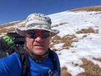
Did I mention that the berg is quite green at the moment:
The shortcut way down Didima dome. Jip, we went down there. It's actually not as steep as it looks:
Closer to the top:
And finally, looking down towards Thlanyaku pass:
Sanet forgot to remove her earrings.......all that extra weight!
We met 2 Basuthu guys on Grays pass, and walked with them pretty much all the way till the point where we turned right off the ridge to go to Didima cave. The older gentlemen could only speak afrikaans, the younger only english. Interesting.
Did I mention that the berg is quite green at the moment:
The shortcut way down Didima dome. Jip, we went down there. It's actually not as steep as it looks:
Closer to the top:
And finally, looking down towards Thlanyaku pass:
Please login or register to view the images attached to this post.
The following user(s) said Thank You: diverian, elinda, bergzentinel8666, AdrianT, TheRealDave, GriffBaker, WarrenM
Please Log in or Create an account to join the conversation.
