
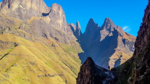
Ship’s Prow Pass
Planning a Berg hike this weekend. Day 1: One day summit of Grays from Monk's Cowl parking area, camp on top. Day 2: Down Ship's Prow, contour left, camp close to Blind Man's Corner. Day 3: Back to car.
Does anyone perhaps know what the status is of the contour path between the base of Ship's and the junction with Shada Ridge (the section in red in the image below)? I have never done that section before and curious to know whether we should do some mental prep for bush-whacking? Ship's, by itself, will 'eat' into our fixed quota of tolerance...
")
Please login or register to view the image attached to this post.
Please Log in or Create an account to join the conversation.
- supertramp
-
- Offline
- Elite Member
-

- Posts: 227
- Thank you received: 465
Did Ships last year about the same time of year. The contour path is fairly straight forward slogging, almost identical to the contour path to Grays (weaving in-out the valleys). Only section that had a bit of bush wacking was the crossing of Cowl Fork (refer to image), nothing compared to Ships though. I was ascending Ships and lost the path for a bit on the ridge out of the river, that should not be a problem for you.
Have fun

"To those who are enthralled by mountains, their wonder is beyond all dispute. To those who are not, their allure is a kind of madness." - Mountain
Please login or register to view the image attached to this post.
Please Log in or Create an account to join the conversation.

There is a contour path going out of the Ships Prow valley and over towards Shada Ridge.
That's the good news. The bad news is two fold:
Firstly, finding the exit out of the riverbed. I always look for a large pine tree on the left, the path follows just a couple of meters below it. Not sure if said tree is still there though, else I can send you my track for this route. This section is where the worst of the crawling and bundu bashing will occur. This section is so bad that every time I go through here (either up or down this "path", it pulls gear and clothes out of my backpack!
Your second issue will be that the path eventually disappears just shy of the valley immediately before Shada Ridge. I've given up trying to find the path. None of the tracks I've ever followed for this section had a path. The easiest way to describe the route, is as follows: The contour path is initially clear as it climbs out of the Ships Valley , up the ridge and then turns kind of back on the ridge towards Ships. As you approach the higher and flat section, the terrain will sort of guide you. First walk in a westernly direction (towards the higher section), then turn right (NE) towards Shada Ridge. There were sections of a path here, but nothing that you can conclusively call a path. As you get closer to Shada Ridge, you will clearly see the path going up it. How you get to it is entirely your choice. There is no visible path on this final 400m section. We went sort of a bit to the left, and then down a ridge littered with high stingy plants. Once you get to them, you will know exactly what I am referring to. Then you simply have to traverse through a partly overgrown, boulder strewn riverbed before you get to the path on the South side of Shada Ridge. From here it's smooth sailing all the way home.
Question: Why do you want to sleep on the section closer towards BMC? The terrain is fairly sloped if I remember correctly, and you might struggle to find water here, unless you camp much closer to BMC. Why not rather sleep in the camping spot in Ships Prow? The sunrises from this spot is (for me) probably the best in the entire berg. When the sun comes up, it colours the entire mountainrange in front of you in a soft yellow for a few minutes, which is truly spectacular. This is only about 500m upstream from the exit point onto the path, and with your fitness level it will only add about 2 hours, maybe 2H30min to your day.
Whichever way you decide to go, enjoy!!!
Please Log in or Create an account to join the conversation.

vivo101 wrote: Hey @supertramp
Did Ships last year about the same time of year. The contour path is fairly straight forward slogging, almost identical to the contour path to Grays (weaving in-out the valleys). Only section that had a bit of bush wacking was the crossing of Cowl Fork (refer to image), nothing compared to Ships though. I was ascending Ships and lost the path for a bit on the ridge out of the river, that should not be a problem for you.
Have fun
@vivo101
Awesome, thank you so much sir!!!
Did a one day summit of Ship's from Injisuthi camp about 2 years ago, our quota of energy and bush whacking were exhausted to its limits. Can't wait to test them again
Please Log in or Create an account to join the conversation.
- supertramp
-
- Offline
- Elite Member
-
- Posts: 227
- Thank you received: 465
Thanks for the heads-up on those sections, much appreciated. By studying the satellite images from 2020 closely, I can see the section(s) you are referring to where the path disappears for a bit. Will be sure to keep them in mind (and not be hard on myself when losing the path).
With regards to your question of where to camp on night 2. I was thinking of that very campsite you are referring to (the one we used on our trip together) but if we sleep there, our day 2 will be relatively short, as we will "only" be going down Ship's . By looking at the stats for that contour section between the exit point to the contour path and BMC, I see that it is 10km with 700m D+ and 630m D-., hence my question about the state of the contour to determine walking duration. There is a couple of nice camp spots between the base of Sterkhorn and BMC -thus a shorter walk-out on Sunday and reaching Bergview Wimpy in time for lunch
But I will definitely keep that spot very close in the back of mind, thanks! Please Log in or Create an account to join the conversation.
- supertramp
-
- Offline
- Elite Member
-
- Posts: 227
- Thank you received: 465
That section after you eventually leave the Ships Riverbed and get onto the contour path can be likened to walking on the escarpment, i.e. easy and fast walking. That final section where the path then disappears where you descend down to the base of Shada ridge is also easy to walk on, basically covered in low growing grass (except for the stingy higher growing plants). The slowest section would probably be the final section where you cross the riverbed section to get up onto Shada ridge. The best description I can give for comparative purposes (based on terrain we have hiked together), would be the section of contour path immediately north of Judges pass, there at the bottom where you then walk through rocks and grass for about 200m to get back on the contour path to Corner pass.
Hope this helps you to determine the time duration to get back to camp should you decide to sleep over at the Ships Prow campsite.
Enjoy!!!
Please Log in or Create an account to join the conversation.
I just have a comment, Should you not be taking the south gully of Ships? I have heard that the North gully is dangerous with lots of lose rocks and rockfalls
enjoy your hike and be save.
Please login or register to view the image attached to this post.
Please Log in or Create an account to join the conversation.


Maybe you heard that from someone who read it in a David Bristow book? They should spend more time reading and researching on VE!
It is precisely the well researched, well considered, and properly assessed danger that attracts many of us to attempt this sort of thing, and to safely take on the challenge based on ability and experience. Once you have done umpteen of the more difficult passes (Ifidi, Pins, Nguza, Injisuthi, Hilton etc) in the berg, it is not a big step up from these to attempt Ships Prow North Pass (Ships Prow North Pass is in fact safer than at least three of the other passes I have mentioned).
Anyway, although neither of the Ships Prow passes should be taken for granted, or attempted by inexperienced hikers, there is nothing wrong with ultra experienced Drakensberg hikers (of the likes of Riaang and supertramp) having a go at Ships Prow North Pass, which has been safely done by many of the experienced VE members.
Please Log in or Create an account to join the conversation.
- tonymarshall
-

- Offline
- VE Advisory
-

- Posts: 770
- Thank you received: 2244
Please Log in or Create an account to join the conversation.

Please Log in or Create an account to join the conversation.
- tonymarshall
-
- Offline
- VE Advisory
-
- Posts: 770
- Thank you received: 2244
