
WOLKBERG HIKE REPORT JANUARY 2015
27 Jan 2015 16:09 - 27 Jan 2015 16:50 #62721
by Redshift3
“You need special shoes for hiking — and a bit of a special soul as well.”
Terri Guillemets
WOLKBERG HIKE REPORT JANUARY 2015 was created by Redshift3
WOLKBERG HIKE REPORT JANUARY 2015 (KLIPKRAAL TO SERALA PEAK SOUTH EAST ROUTE OVER DEVILS KNUCKLES LOOP)
As clearly stated in “susanalkema’s” or Susan’s WOLKBERG HIKE REPORT MARCH 2014 (SERALA PEAK LOOP), this paradise is no easy endeavour.
Thanks to valuable information obtained from Susan through the Vertical Endeavour website, and a lot of planning, I hereby submit the following report on the WOLKBERG WILDERNESS AREA.
Our team consisted of:
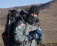
1. Vincent Martinez – Keen adventurer and seasoned hiker.
2. Heinrich Human – Co-navigator, photographer, keen birder with a passion for orchids.
3. Steven Mavromatis – Co-navigator, keen birder, regular hiker, and videographer for the trip.
Firstly for those that are not aware, the Wolkberg is a mountain range in Limpopo Province, South Africa. It constitutes a northern subrange of the Drakensberg system. The range extends for about 30kms (19 miles) in a NW/SE direction north of Sekhukhuneland. The nearest towns are Haenertsburg and Tzaneen.
The range forms a high plateau, reaching up to 2126m in height at the Ysterkroon (Iron Crown)- its highest point. Other conspicuous peaks are the 2050m high Serala, the 1838m high Mamotswiri, the 1667m high Magopalone, and the 1611m high Selemole.
The Wolkberg is the source of many small mountain streams, as well as the Mohlapitse and Ga-Selati Rivers, both tributaries of the Olifants River.
The Plan:
Day1: To arrive at the Serala Forest Station at midday from our home town of Nelspruit. Pay at the office and head down to Klipkraal camp site in a SE direction, approximately 8km on a jeep track. Special attention was given to find the several waterfalls, especially the Tufa waterfall. Overnight at Klipkraal.
Day 2: This was considered to be the longest or toughest day of the five planned days. We would leave the Klipkraal camp site and head in an easterly direction up along the mountain ridge, avoiding the Wonderwoud forest and the difficult ridge of the Devil’s Knuckle’s. Passing the Southern Plateau and down into Tahbina Camp and waterfalls.
Day 3: Leave Tahbina Camp and head up the back of Devil’s Knuckles, go down the northern side of Devil’s Knuckles via The Chain, and then over the grasslands into Wonderwoud. Once we were in the forest, we were to find the Northern Wonderwoud Camp Site and overnight.
Day 4 & 5: On Day 4 we would then pick up the path heading from the campsite up and over Kruger’s Nose. We would continue on to Cleo’s Pools Camp Site and drop off our backpacks. We would continue and summit Serala Peak to the trig beacon and back down to camp again. We would then decide, depending on our progress and weather conditions, whether or not to spend a second night at Cleo’s Pools, or to head back down into the Wonderwoud and home. At worst, if we were under any kind of pressure, we would opt for the easier route north of the Wolkberg Mountain, past the MCSA hut and home on the forestry road!
Day 6: Kept spare in case we needed to stay an extra day whatever the reason.
The Reality:
Day 1:
Distance 7.89 km
uphill 132 m
Elevation max 1,558 m
downhill 725 m
Elevation min 976 m
Wikiloc Link Day 1
We made it to Serala Forest Station by midday, met the station officer and gave him our planned route on a detailed map, contact details, etc. The station officer’s name was Fana. He was very friendly and wished us a safe hike, telling us to pay when we returned. We left our vehicle at the campsite near the ablution block and donkey. We set off in search of the jeep track to Klipkraal. We picked up the track and made great progress. The waterfalls were all marked with stone cairns next to the road. The first was a pretty little part of the stream, the second, however, was a dream come true! The Tufa Waterfall and pools were stunning. After a quick dip and many photographs, we headed down to Klipkraal Camp Site. From here you can see the last of three waterfalls. These are well worth a visit and make a great place for a swim. The campsite is a large flat area under indigenous trees. It was obvious that many folk drive down to Klipkraal and camp. A great night around a protected fire was had by all.
Day 2:
Distance 9.74 km
uphill 1,084 m
Elevation max 1,797 m
downhill 573 m
Elevation min 952 m
Wikiloc Link Day 2
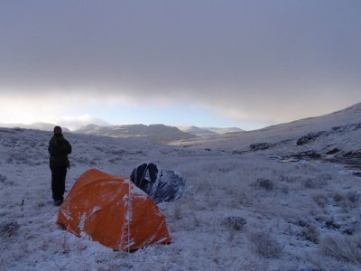
We had an early start crossing the river and headed up the first small hill that makes up the ridge towards Devils Knuckles. There was evidence of an old path and a few stone cairns. We climbed peak after peak to avoid dense vegetated ravines. As the weather started to turn for the worse in the afternoon, we set up camp just short of Tahbina Falls. We were low on water as we had stayed on the ridges all day. Fortunately we were able to collect 3.5lt of rain water in a bivy overnight.
Day 3:
Distance 6.27 km
uphill 733 m
Elevation max 1,865 m
downhill 821 m
Elevation min 1,414 m
Wikiloc Link Day 3
Wet and disappointed for not making our target the day before , we packed up and started for the day. The early morning fog was dense and, at times, we had as little as 10m visibility. The gps was invaluable. We crossed the last ridge and headed for the back of the highest point of Devil’s Knuckles. We found the stone cairn leading down the North face, followed the only logical safe route and found the “Chain”. This was a relief as it confirmed our position as correct and aided us on getting down. At that moment the wind cleared the fog and we could clearly see the valley below -the “small” piece of forest below Kruger’s Nose and the exact path up to Cleo’s Camp. With renewed enthusiasm we set off, imagining a swim and a comfortable camp later that same day. To cap off the moment, Heinrich found a Berg Adder basking in the misty sun (this was one of our many must finds)
  . We also found a rare orchid (Disa aristata)
  , which we only expected to see on Serala! All in all, things couldn’t have been better………….! We cleared the valley and headed for the shortest path through the northern tip of Wonderwoud Forest……..that’s were it all fell apart. The forest was dense, hot, and had many small valleys or ravines, each making our destination a little tougher to get to. We made such slow progress (about 100m an hour, even with the aid of a sharp panga) that we decided there wouldn’t be enough time to reach Northern Wonderwoud Camp. We opted to find a suitable camping area near water. We set up camp, filled our bellies with a hot meal and collected sufficient water from a nearby stream.
Day 4:
Distance 3.83 km
uphill 497 m
Elevation max 1,830 m
downhill 240 m
Elevation min 1,423 m
Wikiloc Link Day 4
It rained in the early hours of the morning and we awoke to a dense fog, in an already dense forest. We had, fortunately, taken a compass bearing the day before when we could see Kruger’s Nose (the gps was made redundant by the dense forest canopy). We devised a method of dropping the backpacks, cutting and slashing a way forward on a compass bearing towards Kruger’s Nose. We would then return to fetch our packs when we were certain that we had made the correct progress. This paid off. After some anxious moments and no sign of any path, we stumbled upon a clearing, which took us out of the top of the forest and to the base of Krugers Nose. From here on there was a clear path ahead – an enormous relief for us. We carefully made our way up the steepest part of the climb, reaching the top with no further disappointments. We were greeted by a huge vista of the Limpopo region, as well as a single, soaring Black Eagle. One last hill left between us and Cleo’s pools. We followed a clear path and made camp at Cleo’s Pools. We spent the afternoon drying out our gear, taking photographs and cooling of in the clear stream. I rate this as one of the best, if not the best, campsite I have ever camped in.
Day 5: (Serala Summit)
Distance 3 km
uphill 295 m
Elevation max 2,060 m
downhill 295 m
Elevation min 1,756 m
Wikiloc Link Day 5 SUMMIT
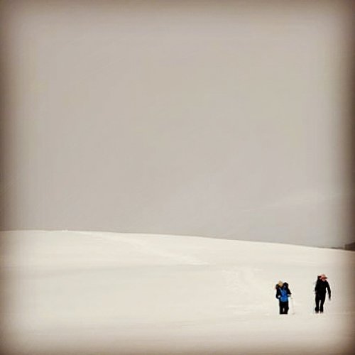
Decision time! We woke to the usual blanket of mist, had coffee and started our 1.5km summit to the trig beacon. Again the gps was invaluable. We found the highest point and returned to Cleo’s Pools. As per our original plan, we discussed our options. We all agreed that another two nights stumbling around the Wonderwoud was not an option.
Day 5: (Route March)
Distance 19.32 km
uphill 820 m
Elevation max 1,838 m
downhill 1,018 m
Elevation min 1,055 m
Wikiloc Link Day 5 FINAL
We packed up and set off in a north easterly direction down, and towards the MCSA Hut, on a well beaten path. Making faster progress than we had made in the last four days, we decided to push on past the MCSA’s Hut. Driven by the desire for a warm shower back at the camp and a short drive to Haenertsberg for a steak, egg, chips and beer, we perservered forward. As nightfall approached, the thought of pitching camp surrounded by a deadly silent Eucalyptus plantation was so depressing we pushed on. Like zombies, we trudged along the forestry road well into the dark, arriving back at Serala Forest station after eight. We ended up clocking 20kms from Cleo’s Pools to Serala Station, excluding the 3km round trip for the summit.
We pitched our tents on the soft, flat camping sites and slept soundly.
Day six: Waking up to staff arriving for work, we made coffee while we fired up the donkey boiler. A hot shower, breakfast and off to settle our bill.
We headed off by vehicle to the Iron Crown Peak and onto Haernetsberg for our reward.
CONCLUSION: (to add to Susan’s list)
The few very valuable lessons we learned was the following:
1. A panga and pruning scissors are essential! Take essential climbing ropes/gear with for going down the steep sections.
2. Get used to river crossings (eventually you get tired of taking off shoes and putting them back on again, so wet shoes it is!)
3. Which is why you will never pack in enough dry socks (grandma-feet deluxe).
4. Wear long pants, unless you want really scratched legs (bush whacking is inevitable and even the real paths make real damage).
5. You can have good cuisine hiking food with little effort and weight, we used Back Country Freeze dry meals.
6. Making fires are not the best option for several reasons, make sure you carry enough fuel for cooking.
7. We found the good old 1:50,000 map covered in plastic with all our reference points pre-marked and a good old compass essential. The gps was invaluable except in the forest, due to canopy cover a standard compass bearing will keep you in the correct general direction!
8. All routes, co-ordinates and gradients are freely available on wikiloc.com.
9. Please feel free to contact us for more photograps,the video link, aswell as other orchid and bird identifications, or any other questions you may have!
Enjoy
PS will try and post photos later
As clearly stated in “susanalkema’s” or Susan’s WOLKBERG HIKE REPORT MARCH 2014 (SERALA PEAK LOOP), this paradise is no easy endeavour.
Thanks to valuable information obtained from Susan through the Vertical Endeavour website, and a lot of planning, I hereby submit the following report on the WOLKBERG WILDERNESS AREA.
Our team consisted of:
1. Vincent Martinez – Keen adventurer and seasoned hiker.
2. Heinrich Human – Co-navigator, photographer, keen birder with a passion for orchids.
3. Steven Mavromatis – Co-navigator, keen birder, regular hiker, and videographer for the trip.
Firstly for those that are not aware, the Wolkberg is a mountain range in Limpopo Province, South Africa. It constitutes a northern subrange of the Drakensberg system. The range extends for about 30kms (19 miles) in a NW/SE direction north of Sekhukhuneland. The nearest towns are Haenertsburg and Tzaneen.
The range forms a high plateau, reaching up to 2126m in height at the Ysterkroon (Iron Crown)- its highest point. Other conspicuous peaks are the 2050m high Serala, the 1838m high Mamotswiri, the 1667m high Magopalone, and the 1611m high Selemole.
The Wolkberg is the source of many small mountain streams, as well as the Mohlapitse and Ga-Selati Rivers, both tributaries of the Olifants River.
The Plan:
Day1: To arrive at the Serala Forest Station at midday from our home town of Nelspruit. Pay at the office and head down to Klipkraal camp site in a SE direction, approximately 8km on a jeep track. Special attention was given to find the several waterfalls, especially the Tufa waterfall. Overnight at Klipkraal.
Day 2: This was considered to be the longest or toughest day of the five planned days. We would leave the Klipkraal camp site and head in an easterly direction up along the mountain ridge, avoiding the Wonderwoud forest and the difficult ridge of the Devil’s Knuckle’s. Passing the Southern Plateau and down into Tahbina Camp and waterfalls.
Day 3: Leave Tahbina Camp and head up the back of Devil’s Knuckles, go down the northern side of Devil’s Knuckles via The Chain, and then over the grasslands into Wonderwoud. Once we were in the forest, we were to find the Northern Wonderwoud Camp Site and overnight.
Day 4 & 5: On Day 4 we would then pick up the path heading from the campsite up and over Kruger’s Nose. We would continue on to Cleo’s Pools Camp Site and drop off our backpacks. We would continue and summit Serala Peak to the trig beacon and back down to camp again. We would then decide, depending on our progress and weather conditions, whether or not to spend a second night at Cleo’s Pools, or to head back down into the Wonderwoud and home. At worst, if we were under any kind of pressure, we would opt for the easier route north of the Wolkberg Mountain, past the MCSA hut and home on the forestry road!
Day 6: Kept spare in case we needed to stay an extra day whatever the reason.
The Reality:
Day 1:
Distance 7.89 km
uphill 132 m
Elevation max 1,558 m
downhill 725 m
Elevation min 976 m
Wikiloc Link Day 1
We made it to Serala Forest Station by midday, met the station officer and gave him our planned route on a detailed map, contact details, etc. The station officer’s name was Fana. He was very friendly and wished us a safe hike, telling us to pay when we returned. We left our vehicle at the campsite near the ablution block and donkey. We set off in search of the jeep track to Klipkraal. We picked up the track and made great progress. The waterfalls were all marked with stone cairns next to the road. The first was a pretty little part of the stream, the second, however, was a dream come true! The Tufa Waterfall and pools were stunning. After a quick dip and many photographs, we headed down to Klipkraal Camp Site. From here you can see the last of three waterfalls. These are well worth a visit and make a great place for a swim. The campsite is a large flat area under indigenous trees. It was obvious that many folk drive down to Klipkraal and camp. A great night around a protected fire was had by all.
Day 2:
Distance 9.74 km
uphill 1,084 m
Elevation max 1,797 m
downhill 573 m
Elevation min 952 m
Wikiloc Link Day 2
We had an early start crossing the river and headed up the first small hill that makes up the ridge towards Devils Knuckles. There was evidence of an old path and a few stone cairns. We climbed peak after peak to avoid dense vegetated ravines. As the weather started to turn for the worse in the afternoon, we set up camp just short of Tahbina Falls. We were low on water
as we had stayed on the ridges all day. Fortunately we were able to collect 3.5lt of rain water in a bivy overnight.Day 3:
Distance 6.27 km
uphill 733 m
Elevation max 1,865 m
downhill 821 m
Elevation min 1,414 m
Wikiloc Link Day 3
Wet and disappointed for not making our target the day before
, we packed up and started for the day. The early morning fog was dense and, at times, we had as little as 10m visibility. The gps was invaluable. We crossed the last ridge and headed for the back of the highest point of Devil’s Knuckles. We found the stone cairn leading down the North face, followed the only logical safe route and found the “Chain”. This was a relief as it confirmed our position as correct and aided us on getting down. At that moment the wind cleared the fog and we could clearly see the valley below -the “small” piece of forest below Kruger’s Nose and the exact path up to Cleo’s Camp. With renewed enthusiasm we set off, imagining a swim and a comfortable camp later that same day. To cap off the moment, Heinrich found a Berg Adder basking in the misty sun (this was one of our many must finds) . We also found a rare orchid (Disa aristata) , which we only expected to see on Serala! All in all, things couldn’t have been better………….! We cleared the valley and headed for the shortest path through the northern tip of Wonderwoud Forest……..that’s were it all fell apart. The forest was dense, hot, and had many small valleys or ravines, each making our destination a little tougher to get to. We made such slow progress (about 100m an hour, even with the aid of a sharp panga) that we decided there wouldn’t be enough time to reach Northern Wonderwoud Camp. We opted to find a suitable camping area near water. We set up camp, filled our bellies with a hot meal and collected sufficient water from a nearby stream.Day 4:
Distance 3.83 km
uphill 497 m
Elevation max 1,830 m
downhill 240 m
Elevation min 1,423 m
Wikiloc Link Day 4
It rained in the early hours of the morning and we awoke to a dense fog, in an already dense forest. We had, fortunately, taken a compass bearing the day before when we could see Kruger’s Nose (the gps was made redundant by the dense forest canopy). We devised a method of dropping the backpacks, cutting and slashing a way forward on a compass bearing towards Kruger’s Nose. We would then return to fetch our packs when we were certain that we had made the correct progress. This paid off. After some anxious moments and no sign of any path, we stumbled upon a clearing, which took us out of the top of the forest and to the base of Krugers Nose. From here on there was a clear path ahead – an enormous relief for us. We carefully made our way up the steepest part of the climb, reaching the top with no further disappointments. We were greeted by a huge vista of the Limpopo region, as well as a single, soaring Black Eagle. One last hill left between us and Cleo’s pools. We followed a clear path and made camp at Cleo’s Pools. We spent the afternoon drying out our gear, taking photographs and cooling of in the clear stream. I rate this as one of the best, if not the best, campsite I have ever camped in.
Day 5: (Serala Summit)
Distance 3 km
uphill 295 m
Elevation max 2,060 m
downhill 295 m
Elevation min 1,756 m
Wikiloc Link Day 5 SUMMIT
Decision time! We woke to the usual blanket of mist, had coffee and started our 1.5km summit to the trig beacon. Again the gps was invaluable. We found the highest point and returned to Cleo’s Pools. As per our original plan, we discussed our options. We all agreed that another two nights stumbling around the Wonderwoud was not an option.
Day 5: (Route March)
Distance 19.32 km
uphill 820 m
Elevation max 1,838 m
downhill 1,018 m
Elevation min 1,055 m
Wikiloc Link Day 5 FINAL
We packed up and set off in a north easterly direction down, and towards the MCSA Hut, on a well beaten path. Making faster progress than we had made in the last four days, we decided to push on past the MCSA’s Hut. Driven by the desire for a warm shower back at the camp and a short drive to Haenertsberg for a steak, egg, chips and beer, we perservered forward. As nightfall approached, the thought of pitching camp surrounded by a deadly silent Eucalyptus plantation was so depressing we pushed on. Like zombies, we trudged along the forestry road well into the dark, arriving back at Serala Forest station after eight. We ended up clocking 20kms from Cleo’s Pools to Serala Station, excluding the 3km round trip for the summit.
We pitched our tents on the soft, flat camping sites and slept soundly.
Day six: Waking up to staff arriving for work, we made coffee while we fired up the donkey boiler. A hot shower, breakfast and off to settle our bill.
We headed off by vehicle to the Iron Crown Peak and onto Haernetsberg for our reward.
CONCLUSION: (to add to Susan’s list)
The few very valuable lessons we learned was the following:
1. A panga and pruning scissors are essential! Take essential climbing ropes/gear with for going down the steep sections.
2. Get used to river crossings (eventually you get tired of taking off shoes and putting them back on again, so wet shoes it is!)
3. Which is why you will never pack in enough dry socks (grandma-feet deluxe).
4. Wear long pants, unless you want really scratched legs (bush whacking is inevitable and even the real paths make real damage).
5. You can have good cuisine hiking food with little effort and weight, we used Back Country Freeze dry meals.
6. Making fires are not the best option for several reasons, make sure you carry enough fuel for cooking.
7. We found the good old 1:50,000 map covered in plastic with all our reference points pre-marked and a good old compass essential. The gps was invaluable except in the forest, due to canopy cover a standard compass bearing will keep you in the correct general direction!
8. All routes, co-ordinates and gradients are freely available on wikiloc.com.
9. Please feel free to contact us for more photograps,the video link, aswell as other orchid and bird identifications, or any other questions you may have!
Enjoy
PS will try and post photos later
“You need special shoes for hiking — and a bit of a special soul as well.”
Terri Guillemets
Please login or register to view the images attached to this post.
Last edit: 27 Jan 2015 16:50 by Redshift3. Reason: Correction & add pics
The following user(s) said Thank You: intrepid, diverian, Stijn, JonWells, anthony, ccjoubert, firephish, Smurfatefrog, tonymarshall, Sabine, pfoj, HFc, Captain, Josh of the Bushveld, Drakensbergie, Riaang
Please Log in or Create an account to join the conversation.
28 Jan 2015 08:17 #62726
by firephish
Replied by firephish on topic WOLKBERG HIKE REPORT JANUARY 2015
thanks for the report, this is a hike i've been meaning to do for a while now!
Please Log in or Create an account to join the conversation.
28 Jan 2015 09:44 #62727
by Viking
“Today is your day! Your mountain is waiting, So… get on your way!”
Replied by Viking on topic WOLKBERG HIKE REPORT JANUARY 2015
Thanks chaps, love the pic of the snake!
“Today is your day! Your mountain is waiting, So… get on your way!”
Please Log in or Create an account to join the conversation.

28 Jan 2015 10:38 #62728
by ozymandiasza
Replied by ozymandiasza on topic WOLKBERG HIKE REPORT JANUARY 2015
Nice report, thanks!
I went there in December 2014 for a solo, two night hike. It's gorgeous but quite "hardcore". Wonderwoud was most probably the toughest bush I had to navigate in.
I went there in December 2014 for a solo, two night hike. It's gorgeous but quite "hardcore". Wonderwoud was most probably the toughest bush I had to navigate in.
Please Log in or Create an account to join the conversation.
- ozymandiasza
-

- Offline
- New Member
-

Less
More
- Posts: 8
- Thank you received: 0
28 Jan 2015 13:31 - 30 Jan 2015 09:58 #62729
by Redshift3
“You need special shoes for hiking — and a bit of a special soul as well.”
Terri Guillemets
Replied by Redshift3 on topic WOLKBERG HIKE REPORT JANUARY 2015
Agreed, Wonderwoud was tough. In future we will camp at Klipkraal and vissit the Wondewoud with light gear, only for the day. That dense forest with a five day loaded back pack and a panga......esish to much job 
“You need special shoes for hiking — and a bit of a special soul as well.”
Terri Guillemets
Last edit: 30 Jan 2015 09:58 by Redshift3. Reason: Correction
Please Log in or Create an account to join the conversation.
02 Feb 2015 07:58 - 02 Feb 2015 08:01 #62755
by Redshift3
“You need special shoes for hiking — and a bit of a special soul as well.”
Terri Guillemets
Replied by Redshift3 on topic WOLKBERG HIKE REPORT JANUARY 2015
For those who are curious about the Wolkberg. Five minutes a day, this vid will give you a better picture!
“You need special shoes for hiking — and a bit of a special soul as well.”
Terri Guillemets
Last edit: 02 Feb 2015 08:01 by Redshift3. Reason: Video
The following user(s) said Thank You: Captain, Drakensbergie
Please Log in or Create an account to join the conversation.
11 Feb 2015 14:33 #62824
by Waynem
Replied by Waynem on topic WOLKBERG HIKE REPORT JANUARY 2015
There is a easyer route through and up kruer se neus.. if you know where to look:-)
Please Log in or Create an account to join the conversation.
17 Feb 2015 20:30 #62865
by intrepid
Take nothing but litter, leave nothing but a cleaner Drakensberg.
Replied by intrepid on topic WOLKBERG HIKE REPORT JANUARY 2015
For those who haven't looked through it yet, don't miss the lovely pictures from this trip which were kindly uploaded by Waynem. This is the dedicated Wolkberg album:
www.vertical-endeavour.com/gallery/wolkberg.html
I am very appreciative of all the contributions such as write-ups and photos from various members. I hope it inspires more interest in this little-known mountain wilderness, and I am pleased this site continues to cherish a pride in Southern African mountains.
Take nothing but litter, leave nothing but a cleaner Drakensberg.
The following user(s) said Thank You: Drakensbergie
Please Log in or Create an account to join the conversation.

20 Feb 2015 07:26 #62883
by susanalkema
Replied by susanalkema on topic WOLKBERG HIKE REPORT JANUARY 2015
Very good report!
I am pretty glad that we didn't encounter any snakes...
Photo's taken are absolutely beautiful.
I was thinking that next time we will take the jeep track leading up to the MCSA hut and hike from there. Then skipping the loooooong entry into the more beautiful area.
Definitely going to aim for the waterfalls that you visited next time.
Please Log in or Create an account to join the conversation.
- susanalkema
-

- Offline
- Junior Member
-

Less
More
- Posts: 23
- Thank you received: 21
15 Aug 2017 12:53 #71985
by christiaanvoges
Replied by christiaanvoges on topic WOLKBERG HIKE REPORT JANUARY 2015
Hi
Looks like an amazing place to go visit.
We are planning to go there. Have you by any chance got a map or some GPX track or coordinates you can send me to help navigate around there??
THanks!
Christiaan
Looks like an amazing place to go visit.
We are planning to go there. Have you by any chance got a map or some GPX track or coordinates you can send me to help navigate around there??
THanks!
Christiaan
Please Log in or Create an account to join the conversation.
- christiaanvoges
-
- Offline
- New Member
-
Less
More
- Posts: 5
- Thank you received: 0
