
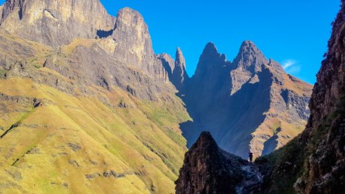
This is most probably the most difficult non-rock pass in the Drakensberg range. A very long river section, which involves boulder-hopping and bush-whacking, is followed by some incredibly steep and sustained grassy slopes in the upper reaches of the pass. It is not frequently used and the spectacular views are not much of a compensation for the frustrating river section.
Rating:
* * 10/10
Difficulty of the pass is rated from 1-10 (10 being very difficult, only to be attempted by the fit and experienced). A subjective quality rating is indicated by the number of stars (1 being low, 5 being the highest). Factors such as scenic beauty and overall experience come into play here, which may differ from person to person.
Access:
Icidi Pass can be accessed by a full day’s walk-in (18 km) from the Mnweni Cultural Centre. The Icidi river valley branches off right from the Mnweni river valley about 2 km before Shepherd’s Cave.
Details:
The distance from Grasscutter’s Cave to the top of Icidi Pass is 4 km with an altitude gain of 1200m.
Route:
There is a faint path with many deviations which follows the left-hand (southern) bank of the river from the start of the Icidi river valley all the way up to Grasscutter's Cave. If you manage to lose the path (it’s very easy to do so), follow the boulder bed of the river, bush-whacking up the slopes to avoid the occasional waterfall. At the point where the path cuts in towards the river and disappears completely, you have to find your own way up the rest of the boulder bed until the upper grassy slopes. Just make sure you stick to the boulder bed until the boulders turn into scree and the steep grassy slopes up to the top of the pass can be reached. From here on, it’s just a never-ending, incredibly steep slog up to the top of the pass at 3100m.
Finding the pass from the top:
Just north of the Icidi Buttress, a large gully and then, a little higher up the slope, a smaller gully can be found. The smaller, northern-most gully is Icidi Pass. There is a small cairn marking the top.
Overnight Spots:
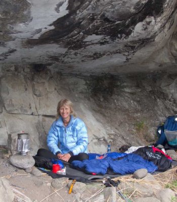
Grasscutter’s cave, which sleeps 12 people, is ideally located for use as an overnight spot when ascending the pass. It is occasionally used by locals and is therefore quite dirty but is nevertheless, a good shelter. Icidi cave, a small hollow which can only just fit 2 people, is situated about 50m in altitude below the top on the left-hand (southern) side of the pass. There are many good camping spots on the escarpment itself.
Water:
The Icidi River has running water until just past the end of the path. From there on, the next water can be found in a river on the escarpment, about 200m from the top of Icidi Pass.
Blog
Icidi Pass
- Details
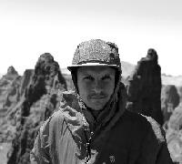
- Written by Stijn Laenen
- Parent Category: Drakensberg
- Category: Passes
- Hits: 6471
Discuss this article
Log in to comment
4a is a great image.
A few more photos...
Hi Ian,Btw Danie,
I mean't to thank you for your stunning pics too! You always had the best eye on our trips together.
I see your wife is equally good at creating atmosphere in the shot.. ????????
Glad you enjoyed them! Thanks for the compliment
This image is hidden for guests.
Haha, she sure does come into her own in the mountains, such a joy and privilege to be able share them with her
This image is hidden for guests.
Hi Ralph,Hi supertramp
Thanks for the great writeup i found it to be really helpful, I've been planning to ascend Ifidi and then descend Icidi in the same trip but fear for the most part has stopped me with both of these passes being rated 10/10. Your writeup with the photos and explanations of the different routes really helped calm some of my fears. Hopefully In the new year i will get these 2 passes done and i will do a writeup of my own.
PS I loved the photos with the full gear, gloves included, it really gives you an idea of what is necessary when dealing with the wild mountain environment.
You are most welcome, glad it could shine some light on the unknown. We were definitely in the same boat regarding the perceived fear.
Happy to share our track if needed. Hope your planned trip becomes a reality real soon. It is so worth it!

Btw Danie,
I mean't to thank you for your stunning pics too! You always had the best eye on our trips together.
I see your wife is equally good at creating atmosphere in the shot.. ????????
I mean't to thank you for your stunning pics too! You always had the best eye on our trips together.
I see your wife is equally good at creating atmosphere in the shot.. ????????
Hi Ralph,
Just to offer you some comfort before you do your massochistic hiking thing.. ????
I was with Riaan on the 2 day version up Infidi and I was like "where's all the bushwacking? and this isn't nearly as bad as you told me it was!?
I did really enjoy the can of coke he shared at the top of the pass though!
Enjoy it! Cheers, Ian

Hi Riaang,
My plan is to do it over 4 days and 3 nights
i would much rather enjoy the experience than slog it out all day and finish in the dark.
I know you're definitely an advocate for Ifidi pass and your write ups are actually what got me interested in this route.
My plan is to do it over 4 days and 3 nights
This image is hidden for guests.
I know you're definitely an advocate for Ifidi pass and your write ups are actually what got me interested in this route.

Ralph,
These passes are quite tough (hence the 10/10 rating), both due to the terrain and mileage involved. However, they are much easier if you split them over multiple days. I've doen Ifidi up a couple of times (note it has 3 scrambling sections near the top - you can read about it and see what they look like in my write-ups posted here on VE). Mostly 1 day trips and they involved an early start and often a finish either as the sun was setting or after dark. However, on m last ascent we split it over 2 days. Day 1 from MCC to (I think) Cycad cave, then day 2 up to Ifidi cave. Couldn't believe what a difference it made. It was sooooo much easier.
So, don't be afraid of them, if you are reasonably fit and have time, stretch your hike over a few days, it really makes it a lot easier and I found that having more time we were so much more relaxed and really got to enjoy the mountain more. A 3 night 4 day hike up Ifidi down Icidi is starting to look more appealing to me by the day now!
Hi supertramp
Thanks for the great writeup i found it to be really helpful, I've been planning to ascend Ifidi and then descend Icidi in the same trip but fear for the most part has stopped me with both of these passes being rated 10/10. Your writeup with the photos and explanations of the different routes really helped calm some of my fears. Hopefully In the new year i will get these 2 passes done and i will do a writeup of my own.
PS I loved the photos with the full gear, gloves included, it really gives you an idea of what is necessary when dealing with the wild mountain environment.
Hi ST
(Interesting the abreviation of our user names is the same
). Thanks for the great writeup and also great images. It does take some time to put a writeup and images together so well done for making the effort. I am going to put up my report of a 5 trip I did last week in the next day or two, just busy editing the images, which takes some time. I will add my thoughts to the thread about why I think people are not posting, which I was busy with.
(Interesting the abreviation of our user names is the same
This image is hidden for guests.
Icidi Pass 3/3
There was one last little bushy, sandy scramble before finally reaching the path. Only then did it start sinking in that we finally managed to complete our much anticipated descent of Icidi pass. Without a doubt the most satisfying and fulfilling moment of my Berg hiking life thus far.Once on the path looking back up the valley, could we see that a recent veld fire (probably 2 seasons ago) has cleared some of the bush on this south bank leading to the pass. We even saw clear signs of a path which may benefit future visitors
We spent a lovely evening at Jubilee Cave basking in our internal glory. Point of note, this cave is absolutely massive!!! We did not see any telltale signs of much local use
The next morning, we had a delightful walk-out and were presented with some amazing views of the Icidi valley. Bongani was super punctual as usual and picked us up for a much-appreciated lift back to MCC.
So, in conclusion, did Icidi Pass deliver on its mysticism and hype? Absolutely and in abundance! It was by far the most rewarding pass we have ever done in the Berg. Was the bushwhacking as bad as we expected? Honestly, no it was not. It probably helped that we prepared mentally for the worst. The long pants were also champs and made everything bearable. Although some of the bush sections were quite thick and above head height, it somehow felt easier in comparison to certain other sections in the Berg (e.g., Ship’s Prow, Pins bottom, overgrown contour paths) where you’ve got parallel branches at shoulder/head height grabbing at your backpack. We also found the riverbed, although quite long, to be a lot of fun. The scenery along the way keeps one engaged and it is simply stunning.
As mentioned in this thread, I would definitely recommend splitting the pass over 2 days, with Jubilee and Grasscutter’s cave being the perfect overnight spot (we did not have time to visit the latter to provide an update on it status). It is worth setting aside a few days to loop it with any of the other passes in the area. The pass is not for beginners and requires a fair amount of familiarity with the Berg, careful navigation at times and a great sense of humor
. We did not encounter any exposed sections on our chosen route. If this pass has been on your bucket list for a while (as it was on ours) and you've been a bit hesitant to do it due to the conditions, I would highly recommend attempting the pass during the months of September and October. It gives the perfect combination of relatively low water levels, less dense vegetation and those epic dark green colours that comes with the change of season.
There was one last little bushy, sandy scramble before finally reaching the path. Only then did it start sinking in that we finally managed to complete our much anticipated descent of Icidi pass. Without a doubt the most satisfying and fulfilling moment of my Berg hiking life thus far.Once on the path looking back up the valley, could we see that a recent veld fire (probably 2 seasons ago) has cleared some of the bush on this south bank leading to the pass. We even saw clear signs of a path which may benefit future visitors
We spent a lovely evening at Jubilee Cave basking in our internal glory. Point of note, this cave is absolutely massive!!! We did not see any telltale signs of much local use
The next morning, we had a delightful walk-out and were presented with some amazing views of the Icidi valley. Bongani was super punctual as usual and picked us up for a much-appreciated lift back to MCC.
So, in conclusion, did Icidi Pass deliver on its mysticism and hype? Absolutely and in abundance! It was by far the most rewarding pass we have ever done in the Berg. Was the bushwhacking as bad as we expected? Honestly, no it was not. It probably helped that we prepared mentally for the worst. The long pants were also champs and made everything bearable. Although some of the bush sections were quite thick and above head height, it somehow felt easier in comparison to certain other sections in the Berg (e.g., Ship’s Prow, Pins bottom, overgrown contour paths) where you’ve got parallel branches at shoulder/head height grabbing at your backpack. We also found the riverbed, although quite long, to be a lot of fun. The scenery along the way keeps one engaged and it is simply stunning.
As mentioned in this thread, I would definitely recommend splitting the pass over 2 days, with Jubilee and Grasscutter’s cave being the perfect overnight spot (we did not have time to visit the latter to provide an update on it status). It is worth setting aside a few days to loop it with any of the other passes in the area. The pass is not for beginners and requires a fair amount of familiarity with the Berg, careful navigation at times and a great sense of humor
This image is hidden for guests.
Icidi Pass 2/3
We were forced to leave the riverbed on 3 occasions, twice due to a narrowing of the gorge and once because of massive boulders where we could see no plausible way down. I’ll share a few noteworthy points that may be useful. On the Google Earth image below, I’ve overlayed our track in blue against the VE track in red. In most cases, the exit points are quite intuitive, but at Point A (2178m; 28°48'53.17"S ; 28°57'11.98"E) it almost feels natural to want to stay in the riverbed as it still feels quite wide and the bush on the sides does not look very appealing (not that it ever does) . But a closer look quite further down the riverbed predicted some troubles and we duly opted to stick to the gpx track. After exiting the riverbed, Icidi became true to form, and we were confronted with some proper bushwhacking.
On the Google Earth image between Point A and B, one is confronted by a deep side gully coming from the true right. Here, instead of trying to find a crossing point further upstream and having to face some more bush on the opposite side (see where the red and blue track diverge), we decided to turn true left and make our way back to the riverbed. We found a re-entry point easily enough (Point B @ 2051m) and we were happy to be out of the bush and back in the riverbed. The image below was taken looking back up the valley with the deep gully coming from the left (true right). The views were out of this world!
This is the view of our re-entry point back into the riverbed, again looking back up the Icidi valley (Point")
The going was easy in the riverbed (between Point B and C) and one is forced back into the bush again on the true left at Point C to avoid a very deep gorge. The section between Point C and D was definitely the hardest in terms of bushwhacking but was over fast enough.
At point D, upon re-entering the riverbed one is presented with 2 distinct options. To stay in the riverbed until the final exit point to the Jubilee Cave approach or to get onto the opposite (southeastern) bank. This seems to be the disputed point based on previous discussions on this thread where multiple contributors recommended to rather stay in the riverbed if possible (based on hindsight ???? ) We took this to heart and opted to stay in the riverbed. Being close to day’s end, it felt like a wise decision to try and avoid unnecessary bush where possible. This is the view back up the valley from this riverbed section (between Point D and E)
This is the immediate exit at Point E (1866m). The approach path to Jubilee Cave can be seen in blue (the 1st visible sign of any path).
We were forced to leave the riverbed on 3 occasions, twice due to a narrowing of the gorge and once because of massive boulders where we could see no plausible way down. I’ll share a few noteworthy points that may be useful. On the Google Earth image below, I’ve overlayed our track in blue against the VE track in red. In most cases, the exit points are quite intuitive, but at Point A (2178m; 28°48'53.17"S ; 28°57'11.98"E) it almost feels natural to want to stay in the riverbed as it still feels quite wide and the bush on the sides does not look very appealing (not that it ever does) . But a closer look quite further down the riverbed predicted some troubles and we duly opted to stick to the gpx track. After exiting the riverbed, Icidi became true to form, and we were confronted with some proper bushwhacking.
On the Google Earth image between Point A and B, one is confronted by a deep side gully coming from the true right. Here, instead of trying to find a crossing point further upstream and having to face some more bush on the opposite side (see where the red and blue track diverge), we decided to turn true left and make our way back to the riverbed. We found a re-entry point easily enough (Point B @ 2051m) and we were happy to be out of the bush and back in the riverbed. The image below was taken looking back up the valley with the deep gully coming from the left (true right). The views were out of this world!
This is the view of our re-entry point back into the riverbed, again looking back up the Icidi valley (Point
The going was easy in the riverbed (between Point B and C) and one is forced back into the bush again on the true left at Point C to avoid a very deep gorge. The section between Point C and D was definitely the hardest in terms of bushwhacking but was over fast enough.
At point D, upon re-entering the riverbed one is presented with 2 distinct options. To stay in the riverbed until the final exit point to the Jubilee Cave approach or to get onto the opposite (southeastern) bank. This seems to be the disputed point based on previous discussions on this thread where multiple contributors recommended to rather stay in the riverbed if possible (based on hindsight ???? ) We took this to heart and opted to stay in the riverbed. Being close to day’s end, it felt like a wise decision to try and avoid unnecessary bush where possible. This is the view back up the valley from this riverbed section (between Point D and E)
This is the immediate exit at Point E (1866m). The approach path to Jubilee Cave can be seen in blue (the 1st visible sign of any path).
Icidi Pass 1
Hi fellow Berg lovers,Having read the This and That on VE that was recently started, I was forced to do some proper introspection on what role I play (however small) to the lack of activity on the forums. Perhaps my perspective can be extrapolated to a small section of the potential pool of contributors to the forum.Life always seems to be getting into the way, not even to mention the consistent distractions and a never ending to-do-list. What good would it to do share? Is the reward in balance with the effort that goes into a writing a thorough hike report? Will it inspire people to try new routes or to potentially be the nudge to get back out there after a prolonged exodus from the mountains? Or should it suffice just to share photos of our beloved mountain range?
I think my experience with Icidi Pass can be a perfect use case. After many, many a visit to the Mnweni area over the years, whilst doing the Mwneni / Ledges / Manxome / Pins / Fangs / Madonna approach, one is presented with a view of the Icidi Valley, radiating mystical and enticing whispers to the intrepid hiker. Looking down from the escarpment, one is awestruck by the sheer majesty of the views. It is surely one of the most beautiful valleys on this earth. Yet, it is not a pass frequently hiked, probably most famous for its bushwhacking.My wife and I were fortunate to have had the opportunity to do a descent of Icidi pass during a 5-day trip (21 – 26 Sept 2025) to the area, looping it with Madonna Pass. After dreaming about the pass for all these years, and having finally done it, I would have expected from myself to have jumped at the opportunity to do a write-up and to share on VE. Yet almost a month has passed, and I’ve not yet set aside the time to do it (this is my attempt to correct that ????)
Sticking to the narrative of my introduction, I guess that I should start with why I feel that my Icidi pass write-up can be linked to the importance of sharing updates and hike reports with the community. Because, the mountains are a dynamic place and can (and does) change drastically over time. With a flash flood, a pass can undergo massive changes to its riverbed (as was the case with Cockade and Tseketseke passes during 2021). Previously inaccessible (relative) passes can suddenly be opened up and likewise, a section of a sedentary pass, may turn out to be rather dangerous after a sudden transformation. Or a recent veld fire could have cleared some of the vegetation.
With Icidi pass, I’m happy to report that such a change played into the hands of these fortunate 2 hikers (and potentially future ones too). Although this was my 1st time doing the pass, I have a relatively strong feeling that some of the “dreaded” elements of the pass (aka continuous bushwhacking) have been alleviated a bit. By comparing the available satellite images on Google Earth, pre-and-post 2021, it does appear that the riverbed has indeed undergone some transformation. I do however note Tony’s post on 1 Feb 2022 (on this thread), that he did not detect a significant change having done the pass before and after the 2021 floods. For me, the riverbed had a distinct sense of relative ‘newness’, which is usually evident in the lack of vegetation in the riverbed itself as well as the ‘look’ of the sand and rock deposits. A similar feeling to what we experienced on Cockade and Tseketseke before and after 2021. But yeah, this was my 1st time and perhaps there was a bit of a mismatch between expectation vs reality, as we really psyched ourselves up mentally to prepare for the worst. 10/10 difficulty rating and all.
OK, back to the hike itself. Knowing what we were in for, we decided to dust off our old backpacks out of storage. My Osprey Aether 80L redeemed itself, even at its post-retirement age. We followed the VE member advice to rather do a descent which I believe was very solid and would be the preferred method. The discreet suggestion to wear longs pants for this endeavour was probably the single best, practical piece of Berg advice I’ve ever received, thanks Vivo101 ! ???? It also only made sense to try the pass during the season with the combination of least amount of vegetation and low water levels, which I believe was a wise choice.
We slept in Ifidi Cave the night before and woke up to a gloomy sight of very dark, rainy clouds to the west. We hardly started walking when the thunder and rain started to engulf us. Not the best of starts for our highly anticipated day but nothing was going to break our mood. As we passed the small summit cairn, we were faced with this relative daunting view of what was to come.
Just as we started our descent, the rain and wind got more intense and we decided to take shelter in a little cave on the southern side of the summit gully. I’m not sure whether it was ‘Icidi Pass Cave’, as the Slingsby Map indicates it as being at 3119m, which is higher than the summit marked at 3092m. Nonetheless, the little cave was very welcome indeed. We spent the better part of an hour to see whether the storm would pass, had a lovely cup of coffee but ended up deciding to continue our descent even though the weather did not break yet.
We were rewarded soon after and the views going down Icidi were absolutely splendid! The top, grassy part of the pass was quite pleasant and not nearly as steep as we expected.
Finding a good entry point into the riverbed was a little challenging at first (it also got quite misty), but once we were in, the going got a bit easier, for a while at least…
Thanks Riaang!Hi Supertramp,
Hope you guys enjoy this one. I still need to do it, but want to loop it with ifidi pass, which I've done a few times. Also thinking of descending Icidi pass. Please take lots of photos showing all the interesting bits.
Enjoy!!!
Believe we'll be in for a fair bit of "fun". Now just hoping that the weather plays along
CheckLong pants and an extra spoon of "sense of humor" should get you down the pass
...This image is hidden for guests.
This image is hidden for guests.
This image is hidden for guests.
Hi everyone,
We are strongly considering finally giving Icidi Pass a go over this weekend. Plan is to do a descent and looping it with Madonna Pass. Hoping that the bush whacking might be a bit more manageable this time of year
Any advice, inspiration or sanity check will be much appreciated...
We are strongly considering finally giving Icidi Pass a go over this weekend. Plan is to do a descent and looping it with Madonna Pass. Hoping that the bush whacking might be a bit more manageable this time of year
This image is hidden for guests.
Any advice, inspiration or sanity check will be much appreciated...

It depends entirely on where the water is ")
It can be at any or all of your numbered spots. The spot where I normally go is as follows: As you top out at Icidi and look inland, at your 11 o clock there is a depression and a lovely little "gorge" with waterfall. I've always found water here. However, if dry then you will probably have to walk further downstream towards Ifidi side, or even more inland.
It can be at any or all of your numbered spots. The spot where I normally go is as follows: As you top out at Icidi and look inland, at your 11 o clock there is a depression and a lovely little "gorge" with waterfall. I've always found water here. However, if dry then you will probably have to walk further downstream towards Ifidi side, or even more inland.

Thank you for the reply Sabine. Normally, when you get to the top of Icidi Pass where do you look for that stream on the below image?
There is normally a little stream flowing near the top of Icidi. However, the rains this year have been scarce that it might be dry now.
I was at the top of Mnweni end of April and most surprised that the river there was hardly flowing. We had to go further South to where we normally camp to find suitable water.
I was at the top of Mnweni end of April and most surprised that the river there was hardly flowing. We had to go further South to where we normally camp to find suitable water.
I read on the description of Icidi Pass (www.vertical-endeavour.com/blog/38-drakensberg/passes/127-icidi-pass.html) that there is water at the top of the pass but it doesn't say if it applies to summer or winter. Does anyone know if there will be water at the top of Icidi in two weeks? Any info will be greatly appreciated.
P.S. In a few previous posts, I chatted here with Riaang about a shortcut between Ifidi and Icidi Passes. Unfortunately, I don't have an update if the shortcut work because we had to change our plans and ended up skipping Ifidi/Icidi passes on that hike.
P.S. In a few previous posts, I chatted here with Riaang about a shortcut between Ifidi and Icidi Passes. Unfortunately, I don't have an update if the shortcut work because we had to change our plans and ended up skipping Ifidi/Icidi passes on that hike.
