Didima Gorge Camping
08 Apr 2016 10:34 #67750
by Stijn
Didima Gorge Camping was created by Stijn
We're planning a chilled, exploratory hike to the Didima Gorge at the end of the month. The idea is to hike in via the Solar Cliffs and find a good spot to set up a "base camp" a little way up the gorge from where the path starts climbing up the slope past Leopard Cave. This way we'll be well off the path to avoid the smugglers' traffic and also in the heart of the gorge and closer to the pools.
We'll be spending 2 days in this area and the group may end up being fairly large, so it would be great to have a fairly comfortable campsite for 4-5 tents. Has anybody explored up the gorge itself before and is it likely that there will be some good spots to camp on the grassy slopes? If the grass slopes drop quite steeply into the river, we may have a problem..
We'll be spending 2 days in this area and the group may end up being fairly large, so it would be great to have a fairly comfortable campsite for 4-5 tents. Has anybody explored up the gorge itself before and is it likely that there will be some good spots to camp on the grassy slopes? If the grass slopes drop quite steeply into the river, we may have a problem..
Please Log in or Create an account to join the conversation.

08 Apr 2016 11:59 #67751
by firephish
Replied by firephish on topic Didima Gorge Camping
I've only camped near the big pool at the junction of the Didima and Mhlwazini river, quite a few nice spots there. Would also be interested in any nice spots higher up ... pls report back if you find any 
The following user(s) said Thank You: Stijn
Please Log in or Create an account to join the conversation.
08 Apr 2016 12:29 #67753
by tonymarshall
Replied by tonymarshall on topic Didima Gorge Camping
I've explored the whole gorge extensively, and the only decent spots close to the river that could take several tents are the area near the junction with the Mhlwazini River (firephish), and the Upper Didima campsite near the junction with the Thuthumi River at the base of Phillips Folly. There may be spots for single tents here and there, but in general the terrain is steep.
Further from the river, above the lower cliffs, I think there is a large flattish area near Forest Cave and Shirleys Cave, close to some side streams for water, but this is close to the path. I will just have to check some old photos to confirm this for you.
Further from the river, above the lower cliffs, I think there is a large flattish area near Forest Cave and Shirleys Cave, close to some side streams for water, but this is close to the path. I will just have to check some old photos to confirm this for you.
The following user(s) said Thank You: Stijn
Please Log in or Create an account to join the conversation.
- tonymarshall
-

- Offline
- VE Advisory
-

Less
More
- Posts: 770
- Thank you received: 2244
08 Apr 2016 12:52 #67755
by Stijn
Replied by Stijn on topic Didima Gorge Camping
Thanks Tony. I'm not familiar with all the unmarked caves in the gorge either, so if you could share some spots that are worth including in our explorations, that would be great ") Feel free to PM me instead if you'd rather not have these details advertised on the forum.
Feel free to PM me instead if you'd rather not have these details advertised on the forum.
Feel free to PM me instead if you'd rather not have these details advertised on the forum. Please Log in or Create an account to join the conversation.
09 Apr 2016 09:39 - 09 Apr 2016 09:56 #67765
by tonymarshall
Replied by tonymarshall on topic Didima Gorge Camping
There are two ‘formal’ campsites in Didima Gorge, both of which are marked on the hiking maps, but are more accurately positioned on Slingsby’s map. I imagine in decades gone by these were well maintained, with the grass kept trimmed, and the campsites being easy to spot because of this. Unfortunately this is no longer the case, and a trained eye is needed to spot the level areas which can be used to tent on among the long grass, shrubs and weeds.
The campsite at the top end of the gorge is known as Upper Didima campsite, and is located on the terrace above the Didima River at the base of Phillip’s Folly just off the path near the Didima River crossing, close to the confluence of the Thuthumi and Didima Rivers. This is shown in the photo below which was taken from across the river near Sebaaieni Cave, with our tents circled. Little Saddle dominates the skyline at the centre of the photo, with Windsor Castle to the right, and a rare view of Sugarloaf, a lower free standing peak on the left of the photo, which usually just blends in with the rest of the escarpment and isn’t visible.
Our tents at Upper Didima campsite in 2011. Imagine how pleasant this would be if the grass was cut and the area well maintained. Sebaaieni Cave is visible in the background, in the rock band 'above' the tents.
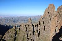
There is a path running the length of Didima Gorge, from the river crossing at the south western upstream end of the gorge to the junction with the Mhlwazini River at the north eastern downstream end, which keeps to the true right of the gorge (river). This path is clearly visible in the photo below from 2012, looking downstream from near the upper end of the gorge, forming the boundary between the green and brown grass, having obviously been used as a firebreak. The typical features of Didima Gorge are clearly visible, the steep sided slopes adjacent to the river stretching to the lower rock band which the river carved it’s way through to form the gorge, the gentler slopes above the lower rock band, and the upper rock band (where the blue circle is). The lower rock band is pretty much continuous for the length of the gorge on both sides, with very few places where it is possible to cross this rock band, except at the upper end of the gorge where there are numerous grass slopes allowing the rock band to be crossed. The upper rock band is more broken, and thinner than the lower rock band. Most of the caves in the gorge are located in these rock bands, although there are a few located at huge boulders which have broken off the lower rock band and rolled down the slopes below.
From the rugged terrain of the gorge, there are very few places suitable for tenting, especially for a larger group with several tents. I have been able to identify one possible tenting spot above the lower rock band, and this is circled with the red circle in the photo above. Shirleys Cave is circled with the blue circle (I may have got this wrong, and it may be the next overhang to the left, but it is clear when you are nearby.) The stream flowing between the two circles would provide easy access to water if tenting at the red circle campsite, and this stream forms the waterfall above Forest Cave, which is at the base of the lower rock band near the edge of the forest on the right slope of the gorge. This stream provided sufficient water at the waterfall at Forest Cave in September 2012, so should be fine for water in April. Neither of these caves have art, although when Shirleys Cave was recorded (by Harald Pager and his wife Shirley) there was a loose rock in the cave with paintings on it, but it has since disappeared.
The photo below shows the area I think can be used for tenting, at the right of the photo. This is the area circled in the red circle from the photo above. Notice how Sugarloaf at the black arrow is barely distinguishable from the escarpment.
Another photo of the same area, with the possible tenting area at the left of the photo below. The stream with the waterfall above Forest Cave for water is very close.
The photo below from March 2014 shows the lower end of the Didima Gorge, where the Didima River exits the gorge and the confluence of the Didima and Mhlwazini Rivers. There is a campsite here, known as Lower Didima campsite, on the flat grassy area to the right of the centre of the photo, although you would have to flatten the long grass first before putting up tents.
So there are three possible tent sites for larger groups in the Didima Gorge area. The campsites at either end of the gorge are close to the river, and provide good access to the pools in the river if you are keen on swimming. There is also a polished rock area just upstream of the Upper Didima campsite, similar to Marble Baths, but not as impressive. The campsite near Forest Cave should be suitable for a few tents, but is quite far from the Didima River, although it is not that difficult to scramble through the lower rock band at the access point to Forest Cave, and thereby get to the pools in the river there.
Stijn, I’ve sent you a pm.
The campsite at the top end of the gorge is known as Upper Didima campsite, and is located on the terrace above the Didima River at the base of Phillip’s Folly just off the path near the Didima River crossing, close to the confluence of the Thuthumi and Didima Rivers. This is shown in the photo below which was taken from across the river near Sebaaieni Cave, with our tents circled. Little Saddle dominates the skyline at the centre of the photo, with Windsor Castle to the right, and a rare view of Sugarloaf, a lower free standing peak on the left of the photo, which usually just blends in with the rest of the escarpment and isn’t visible.
Our tents at Upper Didima campsite in 2011. Imagine how pleasant this would be if the grass was cut and the area well maintained. Sebaaieni Cave is visible in the background, in the rock band 'above' the tents.
There is a path running the length of Didima Gorge, from the river crossing at the south western upstream end of the gorge to the junction with the Mhlwazini River at the north eastern downstream end, which keeps to the true right of the gorge (river). This path is clearly visible in the photo below from 2012, looking downstream from near the upper end of the gorge, forming the boundary between the green and brown grass, having obviously been used as a firebreak. The typical features of Didima Gorge are clearly visible, the steep sided slopes adjacent to the river stretching to the lower rock band which the river carved it’s way through to form the gorge, the gentler slopes above the lower rock band, and the upper rock band (where the blue circle is). The lower rock band is pretty much continuous for the length of the gorge on both sides, with very few places where it is possible to cross this rock band, except at the upper end of the gorge where there are numerous grass slopes allowing the rock band to be crossed. The upper rock band is more broken, and thinner than the lower rock band. Most of the caves in the gorge are located in these rock bands, although there are a few located at huge boulders which have broken off the lower rock band and rolled down the slopes below.
From the rugged terrain of the gorge, there are very few places suitable for tenting, especially for a larger group with several tents. I have been able to identify one possible tenting spot above the lower rock band, and this is circled with the red circle in the photo above. Shirleys Cave is circled with the blue circle (I may have got this wrong, and it may be the next overhang to the left, but it is clear when you are nearby.) The stream flowing between the two circles would provide easy access to water if tenting at the red circle campsite, and this stream forms the waterfall above Forest Cave, which is at the base of the lower rock band near the edge of the forest on the right slope of the gorge. This stream provided sufficient water at the waterfall at Forest Cave in September 2012, so should be fine for water in April. Neither of these caves have art, although when Shirleys Cave was recorded (by Harald Pager and his wife Shirley) there was a loose rock in the cave with paintings on it, but it has since disappeared.
The photo below shows the area I think can be used for tenting, at the right of the photo. This is the area circled in the red circle from the photo above. Notice how Sugarloaf at the black arrow is barely distinguishable from the escarpment.
Another photo of the same area, with the possible tenting area at the left of the photo below. The stream with the waterfall above Forest Cave for water is very close.
The photo below from March 2014 shows the lower end of the Didima Gorge, where the Didima River exits the gorge and the confluence of the Didima and Mhlwazini Rivers. There is a campsite here, known as Lower Didima campsite, on the flat grassy area to the right of the centre of the photo, although you would have to flatten the long grass first before putting up tents.
So there are three possible tent sites for larger groups in the Didima Gorge area. The campsites at either end of the gorge are close to the river, and provide good access to the pools in the river if you are keen on swimming. There is also a polished rock area just upstream of the Upper Didima campsite, similar to Marble Baths, but not as impressive. The campsite near Forest Cave should be suitable for a few tents, but is quite far from the Didima River, although it is not that difficult to scramble through the lower rock band at the access point to Forest Cave, and thereby get to the pools in the river there.
Stijn, I’ve sent you a pm.
Please login or register to view the images attached to this post.
Last edit: 09 Apr 2016 09:56 by tonymarshall.
Please Log in or Create an account to join the conversation.
- tonymarshall
-
- Offline
- VE Advisory
-
Less
More
- Posts: 770
- Thank you received: 2244
09 Apr 2016 13:50 #67768
by Stijn
Replied by Stijn on topic Didima Gorge Camping
Thanks Tony - I really appreciate the thorough reply and photos!
Please Log in or Create an account to join the conversation.
09 Apr 2016 14:42 #67769
by diverian
Replied by diverian on topic Didima Gorge Camping
@tonymarshall Hi Tony , what is the significance of this area being marked as the "Didima Special Conservation Area" on the geomaps. Are there any restrictions that you are aware regarding access to this area other than the Amafa restrictions regarding visiting caves with paintings in them, or is this a case of nobody in charge really bothers anymore ?
Please Log in or Create an account to join the conversation.

09 Apr 2016 19:08 - 09 Apr 2016 19:31 #67773
by tonymarshall
Replied by tonymarshall on topic Didima Gorge Camping
Hi Ian, I don't know the significance of the "Didima Special Conservation Area" being marked on the map and have often wondered about it. At first glance it appears obvious to relate it to the concentration of caves with paintings in the area, but from the geographic boundaries shown on the map I suspect it has more to do with the natural forest in the area (it excludes the cave most well known for paintings in the area). I really don't know what it is, and I am not aware of any additional restrictions to the standard AMAFA ones, and if there are any additional restrictions (and I don't think there are) they have not been well publicised at all.
Recently there have been several posts on the forum relating to poor enforcement/education/follow up by the authorities and I think this has become the norm, and nobody really bothers with hikers or enforcement anymore. I clearly remember in the 80s and 90s being 'interviewed' on departure by the rangers to ensure that you know where you are going, have the correct stuff etc, to offer route advice, and so that they know where you will be if a rescue is needed. On your return you usually had a chat, and they would even make remarks like you are early or late, or chit chat about this or that cave, what game you saw etc. It was apparent that they took an interest in the register and where you were going, and checked up as they should. Recently I have seen several entries in registers weeks old not signed off by hikers on their return (or endorsed by the authority that they have phoned the hike leader to confirm their return), and I wonder if this was even noticed. I have written route descriptions in the register that should make the person watching over my shoulder's eyes pop out of their head (such as Christmas Pass and False Tseketseke Pass and relevant to this topic Bothas Cave to Leopard Cave down the cliffs of the gorge through the forest) but they didn't even bat an eyelid. I think nowadays the hikers know more about the hiking routes than the rangers (perhaps a generalisation unfair to some rangers, but I suspect this is largely the case).
Finally, I have long suspected that the geomaps are produced primarily for the use of EKZNW, and they just publicise them as hiking maps for hikers to be able to sell them. Why else would information relevant to hikers not be indicated on the maps, and the massively thick reserve/area borders irrelevant to hikers blocking out hundreds of metres of contours be shown on the map? I am also convinced there is a financial motive in EKZNW not removing paths that no longer exist from the maps, and that this actually places hikers in danger.
Last edit: 09 Apr 2016 19:31 by tonymarshall.
Please Log in or Create an account to join the conversation.
- tonymarshall
-
- Offline
- VE Advisory
-
Less
More
- Posts: 770
- Thank you received: 2244
10 Apr 2016 19:14 #67788
by biomech
Replied by biomech on topic Didima Gorge Camping
I agree for the most part with Tony's generalisation that the Rangers are not well aware of the various routes in the mountains they are supposed to be protecting. I would like to, however, point out one of the exceptions I have come across recently.
When my wife and I, along with Ghaz and Hobbitt were at Lotheni in mid-March, the person attending to the shop (I didn't get her name) at the camp actually asked about the quality of the paths in the area (which were non-existent more than 2 - 3 km outside of the camp) and stated that there should at least be a path between the camp and Yellowood Cave and Ash Cave respectively. She then proceeded to insist that I fill out a form indicating the bad state of the path for her to send to the relevant person in order to get the path maintenance people to come and maintain the paths. I thought that this was quite positive as it at least demonstrated an awareness of the problem.
The point about the paths on the map being incorrect is also relevant in the context of Lotheni. The geomaps show paths up to the top of eNtubeni Pass and Lotheni Pass (2nd or 3rd Edition). Slingsby's map shows the path ending at Ash Cave (which is probably more accurate today). Our experience is that there is no path up Ka-Masihlenga / Uklebe Pass beyond Yellowood Cave and no path beyond the Eagle Rock trail near to the Lotheni Camp on the escarpment side. I do understand the that area is rarely hiked, but it could be dangerous to capable hikers who visit and are not familiar with the Berg and navigation in these environs.
Anyway, that my 2c on the matter!
The following user(s) said Thank You: DeonS
Please Log in or Create an account to join the conversation.