
Pins Pass
21 Oct 2022 10:17 - 22 Oct 2022 06:55 #78076
by tiska
One more idea on the route. With an early start in summer, you could descend Mnweni Pass, be at the bottom by 7.30 to 8 and head up Pinns on the same day. Descending Mnweni Pass isn’t that strenuous, not with the path.
You’ll miss a nice camp in the Mnweni valley of course.
You’ll miss a nice camp in the Mnweni valley of course.
Last edit: 22 Oct 2022 06:55 by tiska.
The following user(s) said Thank You: Drakie1
Please Log in or Create an account to join the conversation.

11 Nov 2022 16:17 #78123
by Drakie1
At 13:00 Sunday 6 November two of us started hiking from the drop off point up the valley below Rockeries. We reached the camping spot just above the confluence of the Ntonjelana and the stream coming down Rockeries by 17:30. It was quite hot for most of the afternoon.
On Monday morning Rockeries pass was covered in mist but we managed to start hiking from our camp by 8:00. We went up Rockeries quite slowly, taking pictures whenever the weather allowed. We reached the top of Rockeries by 12:30, sat down and had lunch. With dark clouds in the sky we headed for Mponjwana cave where we spent the night. By 23:30 it started raining and continued raining until after 11:00 on Tuesday. It did not really bother us because our plan was to hike across to Mnweni pass, descend Mnweni and camp at Chi Chi for the night before we tackle Pins pass on Wednesday. Within half an our after leaving Mponjwana it started raining again. When we reached the Senqu river it was pouring down. I decided to walk up to the escarpment at Ledges, all along the river. My friend waited for me a couple of hundred meters below the point where the Senqu flows through the little gorge. About an hour later I met up with him again and we hiked to the top of Mnweni. The rain was really coming down as we reached Mnweni and we decided that doing Pins pass the next day would not be such a good idea. So there was no reason to descend Mnweni in pouring rain. We hiked back to the Senqu and camped there for the night. The amount of water coming out of that gorge was something to see!
On Wednesday morning it was mostly clear skies, but doing Pins with all that rain the day before was still not an option. In my mind I played with the idea of camping at Five-star or at the waterfall below Fangs after descending Mnweni and do a solo hike up Fangs and down Madonna with a lighter pack while my friend wait for me down at the camp. Due to circumstances beyond my control that idea remained in my head. We camped just below the first crossing of the Mnweni for the night and walked out to the bridge on Thursday morning where we were picked up by Bongani with his Hilux "taxi".
While coming down Mnweni I spent a lot of time looking at Pins and taking photographs from different angles....... maybe another day.
Please Log in or Create an account to join the conversation.

24 Mar 2023 19:14 - 25 Mar 2023 12:24 #78397
by supertramp
Replied by supertramp on topic Pins Pass
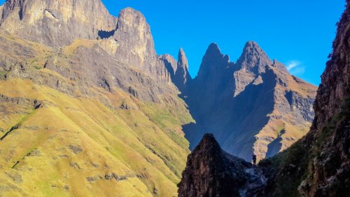
After many a visit to the Mnweni area, Pins Pass and its magical allure from above and below has always been right and center in our minds. This past weekend we finally made use of an opportunity to take it on.
Instead of covering long distances, we decided on more of an adventurous hike, planning to ascend Pins and descend Ledgers Pass over 4 days, leaving ourselves enough time for any eventualities. We arrived at MCC with an ominous storm brewing over the mountains. After being overjoyed at the chance of grabbing a lift on the dirt road, we started our hike from the drop-off point at about 10AM. The weather cleared up soon after and the walk-in on the upper path was, although super wet underfoot, quite uneventful. We found a nice, secluded camp spot in the riverbed, just after crossing the Mnweni river a last time (after the Rwanqa valley turn-off).The next morning saw us reaching the remnants of Chi-Chi bush camp at the base of Pins Pass at about 08:30AM. It is still quite flabbergasting to see how much the riverbed has changed since the floods of 2021. Any future visitors to just take note that the options of tenting at that vicinity has reduced significantly and to plan alternatives accordingly.
From reading up on the previous pass write-ups, we knew that there were 2 main options. One, was to stay in the riverbed and start the steep ascend close the waterfall, or secondly, to get on the grass banks on the left from the get-go and to make our way onwards and upwards. We originally intended to stick to option 2 but not to veer too far from the riverbed, but after a quick reality check on the overgrowth and a scan of the terrain, we decided to adapt our plan and to go “vertical” almost immediately. Initially it was tough going, but we soon embraced and made peace with the steepness and the harsh overgrowth and had an absolute field day systematically working our way sideways (proper “kant berg”) and upwards to the prominent Inner Mnweni Pinnacle. As mentioned in this thread, we had to cross numerous side gullies, but managed them without much of a hassle.
It felt like a huge achievement to reach the base of the pinnacle, and to see the top of the pass reveal itself via the grass gully to the left. We reached Pins Cave at 13:30 as our planned lunch spot and was pleasantly surprised at finding a steady waterfall flowing in front of the cave entrance. After a well-deserved break, we made our way up the grass gully and summitted the pass at 15:00 with great delight. From there we made our way to our camping spot at the Hanging Valley along the highway.
Comparing our final track (in green) against those available on VE and Basecamp, one can clearly see that we followed quite our own way on the grass bank, hehehe. Whether that is a good thing or not, I would not be able to say. I guess I’ll only be able to objectively say after doing option 1 the next time around (preferably > 5 years in the future). Following a GPS track to the letter on a pass like this is a challenge in itself, and it was quite fun relying on one’s own intuition for a change.
Overall, the pass left us with a sense of true “rawness”, and we all felt a bit like real explorers
The views looking back at Mnweni pass, as with the view from Manxome pass, is always stunning. The Pinnacles are a sight to behold. At no point did we feel at risk and did not encounter any dodgy exposed sections. It is an excellent feeling finally being able to tick-off a pass that has been on the to-do-list for what feels like an eternity. The steepness of the pass is a true challenge and, in my view, deserves the 8-difficulty rating as per the Slingsby Maps. I’m also quite confident that the overgrowth may a bit easier to navigate in winter months. The cuts on my legs will serve as a good reminder of our adventure for the next few weeks to come.Now to muster up the courage for Icidi Pass…
Instead of covering long distances, we decided on more of an adventurous hike, planning to ascend Pins and descend Ledgers Pass over 4 days, leaving ourselves enough time for any eventualities. We arrived at MCC with an ominous storm brewing over the mountains. After being overjoyed at the chance of grabbing a lift on the dirt road, we started our hike from the drop-off point at about 10AM. The weather cleared up soon after and the walk-in on the upper path was, although super wet underfoot, quite uneventful. We found a nice, secluded camp spot in the riverbed, just after crossing the Mnweni river a last time (after the Rwanqa valley turn-off).The next morning saw us reaching the remnants of Chi-Chi bush camp at the base of Pins Pass at about 08:30AM. It is still quite flabbergasting to see how much the riverbed has changed since the floods of 2021. Any future visitors to just take note that the options of tenting at that vicinity has reduced significantly and to plan alternatives accordingly.
From reading up on the previous pass write-ups, we knew that there were 2 main options. One, was to stay in the riverbed and start the steep ascend close the waterfall, or secondly, to get on the grass banks on the left from the get-go and to make our way onwards and upwards. We originally intended to stick to option 2 but not to veer too far from the riverbed, but after a quick reality check on the overgrowth and a scan of the terrain, we decided to adapt our plan and to go “vertical” almost immediately. Initially it was tough going, but we soon embraced and made peace with the steepness and the harsh overgrowth and had an absolute field day systematically working our way sideways (proper “kant berg”) and upwards to the prominent Inner Mnweni Pinnacle. As mentioned in this thread, we had to cross numerous side gullies, but managed them without much of a hassle.
It felt like a huge achievement to reach the base of the pinnacle, and to see the top of the pass reveal itself via the grass gully to the left. We reached Pins Cave at 13:30 as our planned lunch spot and was pleasantly surprised at finding a steady waterfall flowing in front of the cave entrance. After a well-deserved break, we made our way up the grass gully and summitted the pass at 15:00 with great delight. From there we made our way to our camping spot at the Hanging Valley along the highway.
Comparing our final track (in green) against those available on VE and Basecamp, one can clearly see that we followed quite our own way on the grass bank, hehehe. Whether that is a good thing or not, I would not be able to say. I guess I’ll only be able to objectively say after doing option 1 the next time around (preferably > 5 years in the future). Following a GPS track to the letter on a pass like this is a challenge in itself, and it was quite fun relying on one’s own intuition for a change.
Overall, the pass left us with a sense of true “rawness”, and we all felt a bit like real explorers
This image is hidden for guests.
Please login or register to view the images attached to this post.
Last edit: 25 Mar 2023 12:24 by supertramp.
The following user(s) said Thank You: elinda, Stijn, JonWells, DeonS, firephish, ghaznavid, Smurfatefrog, tonymarshall, ASL #Bivak, Richard Hunt, Riaang, TheRealDave, GriffBaker, Smithers_23, Carl Gebhard, andrehayward, Lana.1
Please Log in or Create an account to join the conversation.
- supertramp
-
- Offline
- Elite Member
-

Less
More
- Posts: 227
- Thank you received: 464
28 Mar 2023 11:55 #78413
by Riaang
Good write-up Supertramp
As you mentioned, it is a steep pass. That first section had us sweating a lot and breathing hard till we went more horizontal")
Quick couple of questions: When you went vertical, did you go through the rockband section (which is fairly close to the top of the ridge), or did you pass underneath it? I made the "mistake" of going through it, which involved quite a bit of effort and having to deal with some exposure on wet rocks, next time I would definitely go below it.
Did you guys look down the pinnacles towards the Black and Tan wall? Amazing views form here, and this section around the pinnacles I found very fascinating, very rugged, spectacular and vertical.
One final question: The camping spots at Chi-Chi - can you describe in a bit more detail what they look like now? I've never tented here, only bivvied before and even then there wasn't much usable space available, you sort of had to position your spot to fit in with the available flat areas. There were a few of these spots in I'd say a 50m area so a larger group would have to split up, but since we were only 3 hikers each time we could fit in one spot. I'm taking a chance here, but you don't perhaps have a picture to share?
As you mentioned, it is a steep pass. That first section had us sweating a lot and breathing hard till we went more horizontal
Quick couple of questions: When you went vertical, did you go through the rockband section (which is fairly close to the top of the ridge), or did you pass underneath it? I made the "mistake" of going through it, which involved quite a bit of effort and having to deal with some exposure on wet rocks, next time I would definitely go below it.
Did you guys look down the pinnacles towards the Black and Tan wall? Amazing views form here, and this section around the pinnacles I found very fascinating, very rugged, spectacular and vertical.
One final question: The camping spots at Chi-Chi - can you describe in a bit more detail what they look like now? I've never tented here, only bivvied before and even then there wasn't much usable space available, you sort of had to position your spot to fit in with the available flat areas. There were a few of these spots in I'd say a 50m area so a larger group would have to split up, but since we were only 3 hikers each time we could fit in one spot. I'm taking a chance here, but you don't perhaps have a picture to share?
Please Log in or Create an account to join the conversation.

30 Mar 2023 19:15 #78419
by supertramp
Replied by supertramp on topic Pins Pass
Thanks Riaang,
Tenting spots at Chi-Chi: I've camped at the "old" spot a few times before and it used to have space for about 4 - 5 tents but spread out over quite a large area (as you mentioned). After the floods, it was completely washed away. The riverbed in that section is now strewn with boulders and loose sand. There were however about 2 smallish spots for 1- or 2-man tents (our Hilleberg Nallos won't fit) at the same location but the challenge here is that, although flat, the sand is very loose and the tent pegs won't grip and will probably not survive a windy night (unless one uses rocks which I'm not very fond of doing). I would only recommend this as a very last resort. Unfortunately, I do not have photos of this (didn't see it is as worthy
There is however a good new camping spot (suggested by Leonard at MCC), just after taking the sharp left at the junction at the Rwanqa valley. It is in the riverbed, before crossing the Mnweni river a last time (before moving to the grass banks to the left / true right of the river when going up). This is the "New large spot" in the image below. We however decided not to camp here because it is literally in the middle of the path and not aligned with my risk appetite. We used a spot about 300m up the riverbed that was good for 2 tents (the "we camped here" spot). It was out of sight from the path and only an hour's walk from the base of Pins.
View spot of Black and Tan wall: We were tempted to go and have a look but regrettably decided against it. Will definitely make a point of it next time around.
Rockband section: If I can recall which rock band you are referring to, I think we might have actually crossed above it. We moved onto the grass bank and went high quite quickly. There was a point that we basically went straight up a side- gully to the base of the escarpment cliff before traversing across.
Tenting spots at Chi-Chi: I've camped at the "old" spot a few times before and it used to have space for about 4 - 5 tents but spread out over quite a large area (as you mentioned). After the floods, it was completely washed away. The riverbed in that section is now strewn with boulders and loose sand. There were however about 2 smallish spots for 1- or 2-man tents (our Hilleberg Nallos won't fit) at the same location but the challenge here is that, although flat, the sand is very loose and the tent pegs won't grip and will probably not survive a windy night (unless one uses rocks which I'm not very fond of doing). I would only recommend this as a very last resort. Unfortunately, I do not have photos of this (didn't see it is as worthy
This image is hidden for guests.
There is however a good new camping spot (suggested by Leonard at MCC), just after taking the sharp left at the junction at the Rwanqa valley. It is in the riverbed, before crossing the Mnweni river a last time (before moving to the grass banks to the left / true right of the river when going up). This is the "New large spot" in the image below. We however decided not to camp here because it is literally in the middle of the path and not aligned with my risk appetite. We used a spot about 300m up the riverbed that was good for 2 tents (the "we camped here" spot). It was out of sight from the path and only an hour's walk from the base of Pins.
View spot of Black and Tan wall: We were tempted to go and have a look but regrettably decided against it. Will definitely make a point of it next time around.
Rockband section: If I can recall which rock band you are referring to, I think we might have actually crossed above it. We moved onto the grass bank and went high quite quickly. There was a point that we basically went straight up a side- gully to the base of the escarpment cliff before traversing across.
Please login or register to view the images attached to this post.
Please Log in or Create an account to join the conversation.
- supertramp
-
- Offline
- Elite Member
-
Less
More
- Posts: 227
- Thank you received: 464
