
Icidi Pass
02 Jan 2018 13:38 #72544
by ghaznavid
Replied by ghaznavid on topic Icidi Pass
On New Years Eve, myself and WarrenM descended Icidi Pass (we began the day in Ifidi Cave). Seeing as the pass has been the cause of a lot of discussion in the past, here's my thoughts on it.
Important notes:
1) We had light packs, which obviously makes everything a lot easier
2) We had perfect weather, but it was a very hot day
3) The river was full, making rock hopping a bit more tricky, and meaning that the vegetation was in full force
4) Any suggestion of "simple" or "easy" is a reference relative to other difficult grass passes such as Pins, Mbundini or Ships Prow
5) All references are relative to descent of the pass
There is a faint trail near the top of the pass, but it dies fairly quickly. The pass tops out around 3100m, and is a steep grass gully till you hit the river around 2600m. Unlike almost every other grass pass, there is no river in this upper section, which gives you a delightful wide grass gully to zig-zag on - meaning you can make it as steep or gradual as you like. The ground was stable when we did it, which also helps.
The final 30m or so of vertical before hitting the river is where the pass starts getting "fun" (unpleasant might be a better word for it). The vegetation isn't thorny, but conceals holes in the ground and slippery rocks. Care is required to get down this without twisting an ankle.
In my opinion, the pass becomes the walk-out at the point where you hit the river. To make references clearer, any reference to the section above the river will be referred to as the "pass-proper".
Once you hit the river, the game changes. What is unusual here is that the gully gets fairly narrow once you are off the pass-proper, so you are often forced out of the river into the overgrowth to avoid waterfalls and rock pools. In any other region of the Berg, you would normally start moving out of the gully fairly high and get onto a ridge/contour path. If this was the case here, this would be a fairly simple pass, in the same league as the likes of Giants or Judge Pass. But unfortunately this is not the case. I would speculate that it is possible to come up with a line that leaves the river fairly early, and if such a line was developed into a good trail, this pass would be awesome - the views are definitely worth it, and you would skip all the nasty stuff at the bottom. Unfortunately, we either didn't pick the best line, or alternatively there isn't a viable line to skip all of this. What makes matters worse is that we were only able to pick a trail near Jubilee Cave, which is around 1750m, meaning that we had to drop about as much altitude off trail in the riverbed as we did on the pass-proper.
Most of it is fairly standard boulder hopping down a riverbed, much like you find at the bottom of a number of less commonly visited passes. I am not sure what made this boulder hopping less pleasant than normal - I think it was the very hot day. You know a day is hot when I voluntarily actually go into the water, and it happened twice on this day, so it must have been a really hot day!
The river is also full of waterfalls and large rock pools. With the full river, these made for quite a sight
At one point, the valley narrows and you are forced out of the river, putting you into a fairly unpleasant overgrown patch. We re-entered the river by a side gully full of thorn bushes. Not fun!
On one of the sections where we were forced out of the river, we encountered a large number of cycads:
By the lower reaches, the grass slopes on the side were wide enough, and we left the river to follow the bank. About 1km before Jubilee Cave, we found a trail, which we followed to the junction with the Mnweni River, where we turned right to head up towards Mnweni Pass (well, we were heading to Rwanqa Pass at the time, but a certain individual whose VE name is derived from a Persian successor state was not in good shape, definitely not in good enough shape to hit one of the hardest passes in the area).
My thoughts on the pass:
Scenery
From the upper reaches, you can see the Mnweni Needles, Cathedral Ridge and Champagne Ridge, making for quite an amazing view. Rock towers and cliffs tower above you as well, making for a really special spot.
Difficulty
I can't put my finger on why I was so badly trashed by this pass. It was definitely a hot day, perhaps I was tired from doing Ifidi the day before, maybe my lack of hiking in 2017 was starting to show, or perhaps I ate too much over Christmas - or maybe Icidi is just a difficult pass. I can't put my finger on anything that makes this pass particularly difficult. Unpleasant - sure, but not exceptionally difficult.
The fact is that I would never dream of heading down Ships Prow and up another pass on the same day, so perhaps I was just over-estimating my limits/current fitness.
As for the thought of it as the hardest grass pass in the Berg - I don't think it is. If we consider a pass in isolation, I would give this designation to Pins Pass. If we consider round-trip between the car park and the top, It would be a tough call between Pins, Ships Prow, Cathkin Mountain Pass and Mohlesi Pass (on a side note, CMP has no scrambling, although it is mostly not on grass - if Icidi's boulder hopping counts as a grass pass, then so does CMP's). Out of the hardest grass passes I have done, Icidi was definitely the least pleasant, but it wasn't the most unpleasant grass pass I have ever done - South Saddle takes the cake (and eats it too) on that one.
Would I do it again?
No - and I wouldn't recommend it anyone that isn't adamant on bagging every pass in the Berg. Definitely not a pass for beginners either. The pass simply dies on an unpleasant walk-in, much like Ships Prow/CMP. There is nothing wrong with the pass itself, it is just a case of having to survive the approach/walk-out, hopefully with your sense of humour intact.
I would also suggest going down it, rather than up it. It makes a nice loop with Ifidi Pass.
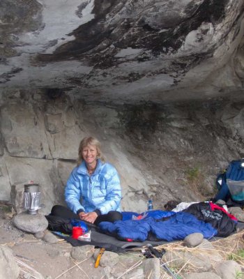
The number of caves on the route mean that you can go fairly light - I would not want to do this with a heavy pack. Cycad Cave was full of fleas, and we didn't stop at Jubilee or Grasscutters Cave - but the same might be true of them - so just be aware of that.
Important notes:
1) We had light packs, which obviously makes everything a lot easier
2) We had perfect weather, but it was a very hot day
3) The river was full, making rock hopping a bit more tricky, and meaning that the vegetation was in full force
4) Any suggestion of "simple" or "easy" is a reference relative to other difficult grass passes such as Pins, Mbundini or Ships Prow
5) All references are relative to descent of the pass
There is a faint trail near the top of the pass, but it dies fairly quickly. The pass tops out around 3100m, and is a steep grass gully till you hit the river around 2600m. Unlike almost every other grass pass, there is no river in this upper section, which gives you a delightful wide grass gully to zig-zag on - meaning you can make it as steep or gradual as you like. The ground was stable when we did it, which also helps.
The final 30m or so of vertical before hitting the river is where the pass starts getting "fun" (unpleasant might be a better word for it). The vegetation isn't thorny, but conceals holes in the ground and slippery rocks. Care is required to get down this without twisting an ankle.
In my opinion, the pass becomes the walk-out at the point where you hit the river. To make references clearer, any reference to the section above the river will be referred to as the "pass-proper".
Once you hit the river, the game changes. What is unusual here is that the gully gets fairly narrow once you are off the pass-proper, so you are often forced out of the river into the overgrowth to avoid waterfalls and rock pools. In any other region of the Berg, you would normally start moving out of the gully fairly high and get onto a ridge/contour path. If this was the case here, this would be a fairly simple pass, in the same league as the likes of Giants or Judge Pass. But unfortunately this is not the case. I would speculate that it is possible to come up with a line that leaves the river fairly early, and if such a line was developed into a good trail, this pass would be awesome - the views are definitely worth it, and you would skip all the nasty stuff at the bottom. Unfortunately, we either didn't pick the best line, or alternatively there isn't a viable line to skip all of this. What makes matters worse is that we were only able to pick a trail near Jubilee Cave, which is around 1750m, meaning that we had to drop about as much altitude off trail in the riverbed as we did on the pass-proper.
Most of it is fairly standard boulder hopping down a riverbed, much like you find at the bottom of a number of less commonly visited passes. I am not sure what made this boulder hopping less pleasant than normal - I think it was the very hot day. You know a day is hot when I voluntarily actually go into the water, and it happened twice on this day, so it must have been a really hot day!
The river is also full of waterfalls and large rock pools. With the full river, these made for quite a sight
At one point, the valley narrows and you are forced out of the river, putting you into a fairly unpleasant overgrown patch. We re-entered the river by a side gully full of thorn bushes. Not fun!
On one of the sections where we were forced out of the river, we encountered a large number of cycads:
By the lower reaches, the grass slopes on the side were wide enough, and we left the river to follow the bank. About 1km before Jubilee Cave, we found a trail, which we followed to the junction with the Mnweni River, where we turned right to head up towards Mnweni Pass (well, we were heading to Rwanqa Pass at the time, but a certain individual whose VE name is derived from a Persian successor state was not in good shape, definitely not in good enough shape to hit one of the hardest passes in the area).
My thoughts on the pass:
Scenery
From the upper reaches, you can see the Mnweni Needles, Cathedral Ridge and Champagne Ridge, making for quite an amazing view. Rock towers and cliffs tower above you as well, making for a really special spot.
Difficulty
I can't put my finger on why I was so badly trashed by this pass. It was definitely a hot day, perhaps I was tired from doing Ifidi the day before, maybe my lack of hiking in 2017 was starting to show, or perhaps I ate too much over Christmas - or maybe Icidi is just a difficult pass. I can't put my finger on anything that makes this pass particularly difficult. Unpleasant - sure, but not exceptionally difficult.
The fact is that I would never dream of heading down Ships Prow and up another pass on the same day, so perhaps I was just over-estimating my limits/current fitness.
As for the thought of it as the hardest grass pass in the Berg - I don't think it is. If we consider a pass in isolation, I would give this designation to Pins Pass. If we consider round-trip between the car park and the top, It would be a tough call between Pins, Ships Prow, Cathkin Mountain Pass and Mohlesi Pass (on a side note, CMP has no scrambling, although it is mostly not on grass - if Icidi's boulder hopping counts as a grass pass, then so does CMP's). Out of the hardest grass passes I have done, Icidi was definitely the least pleasant, but it wasn't the most unpleasant grass pass I have ever done - South Saddle takes the cake (and eats it too) on that one.
Would I do it again?
No - and I wouldn't recommend it anyone that isn't adamant on bagging every pass in the Berg. Definitely not a pass for beginners either. The pass simply dies on an unpleasant walk-in, much like Ships Prow/CMP. There is nothing wrong with the pass itself, it is just a case of having to survive the approach/walk-out, hopefully with your sense of humour intact.
I would also suggest going down it, rather than up it. It makes a nice loop with Ifidi Pass.
The number of caves on the route mean that you can go fairly light - I would not want to do this with a heavy pack. Cycad Cave was full of fleas, and we didn't stop at Jubilee or Grasscutters Cave - but the same might be true of them - so just be aware of that.
Please login or register to view the images attached to this post.
The following user(s) said Thank You: Serious tribe, diverian, elinda, tonymarshall, Captain, ASL #Bivak
Please Log in or Create an account to join the conversation.

03 Jan 2018 06:13 #72552
by WarrenM
Replied by WarrenM on topic Icidi Pass
Thanks Ghaz for the write up
While it is a beautiful pass in respect to scenery, which cannot be disputed, it was very tough, and my legs are very torn up from the overgrowth.
My two cents, we descended the pass, which is also Ghaz suggestion for others looking to do the pass, as opposed to ascending the pass, we did start from Ifidi cave, but it took us most of the morning (all in fact) to descend to the Mnweni river junction, I can't recall what time we got to the junction, but it was close/around midday and we had got a 4.30am start, so for anyone looking to do icidi timing needs to be considered, I think that the ascent would generally need to be done in more than one day.
Please Log in or Create an account to join the conversation.

31 Jan 2022 18:37 #77450
by Sabine
Replied by Sabine on topic Icidi Pass
Has anyone hiked Icidi Pass recently? Or since the big storm February last year when the rivers in the area changed their course slightly?
I did it many years ago, and then there was hardly a path and we had to rely on our GPS. Was wondering if its any better or is it totally overgrown now?
I did it many years ago, and then there was hardly a path and we had to rely on our GPS. Was wondering if its any better or is it totally overgrown now?
Please Log in or Create an account to join the conversation.
01 Feb 2022 08:46 - 01 Feb 2022 08:48 #77453
by tonymarshall
Replied by tonymarshall on topic Icidi Pass
I came down Icidi Pass in June last year, and there was no real damage from the flooding. Having previously done the pass, I had some experience and managed to avoid most of the bush quite easily, although from other peoples comments I think my tolerance for bush is much higher than most peoples. There is still no path on the pass, you get onto a faint path at the river crossing, where you exit the worst bush, upstream of Jubilee Cave, and the path gets better towards Jubilee Cave.
There is already an extensive Icidi Pass thread.
There is already an extensive Icidi Pass thread.
Last edit: 01 Feb 2022 08:48 by tonymarshall.
Please Log in or Create an account to join the conversation.
- tonymarshall
-

- Offline
- VE Advisory
-

Less
More
- Posts: 768
- Thank you received: 2233
03 Feb 2022 14:25 - 03 Feb 2022 14:29 #77458
by Sabine
Replied by Sabine on topic Icidi Pass
Thank you Tony. My biggest concern was the floods from last year, which you say is fine.
Last edit: 03 Feb 2022 14:29 by Sabine.
Please Log in or Create an account to join the conversation.
07 Feb 2022 09:00 #77461
by Riaang
Replied by Riaang on topic Icidi Pass
Are you thinking of doing it anytime soon Sabine? This is the one pass in Mnweni I still have to do, and I have decided that I have to d it this year sometime.
Please Log in or Create an account to join the conversation.

07 Feb 2022 18:25 #77462
by Sabine
Replied by Sabine on topic Icidi Pass
Yes, Riaan, planning it for March
Please Log in or Create an account to join the conversation.
14 Apr 2023 13:51 #78460
by matroskinn
Replied by matroskinn on topic Icidi Pass
Does anyone have any information on a path between Icidi and Ifidi passes at the bottom of the passes? I will be coming down Ifidi and then want to swing over to the bottom of Icidi to go up it the next day. The plan is to start early going down Ifidi and hopefully get to the Grasscutters Cave at the bottom of Icidi on the same day. I've only used the Contour Path to go north/south but it's not available in Mnweni area. Does anyone know a path or even approximate directions on how to get from the bottom of Ifidi to the bottom of Icidi (Grasscutters Cave)? Any information will be much appreciated.
Please Log in or Create an account to join the conversation.
- matroskinn
-

- Offline
- Junior Member
-

Less
More
- Posts: 23
- Thank you received: 10
17 Apr 2023 11:01 #78461
by Riaang
Replied by Riaang on topic Icidi Pass
Hi Matroskinn,
As far as I'm aware, you will head down to the river to find a path than links the two passes. I've never attempted a shortcut higher up between the passes, maybe somebody with experience can advise you. Maybe try the guys at MCC, they would definitely know as it's their backyard")
Looking on Google Earth the northern section of Icidi has fairly high cliffs - much more pronounced than on Ifidi. So, if you cut South from the lower portions of Ifidi, you will climb uphill and then will have to drop all the height gained as you drop down to the river again. My concern here is how steep those cliff walls are. There is possibly a way down, but I don't know of it. If you do come across a shortcut, please let me know.
As far as I'm aware, you will head down to the river to find a path than links the two passes. I've never attempted a shortcut higher up between the passes, maybe somebody with experience can advise you. Maybe try the guys at MCC, they would definitely know as it's their backyard
Looking on Google Earth the northern section of Icidi has fairly high cliffs - much more pronounced than on Ifidi. So, if you cut South from the lower portions of Ifidi, you will climb uphill and then will have to drop all the height gained as you drop down to the river again. My concern here is how steep those cliff walls are. There is possibly a way down, but I don't know of it. If you do come across a shortcut, please let me know.
Please Log in or Create an account to join the conversation.
18 Apr 2023 10:11 #78463
by matroskinn
Replied by matroskinn on topic Icidi Pass
Hello Riaang.
Thank you for the reply. We're not starting at MCC (going to hike in via Bell Traverse) so chatting with MCC staff won't happen.
I'm also concerned about those cliffs between the passes. I spent too many hours this weekend comparing paper map with my Osmand map with topo overlay and Google Map/Earth and the best route I see to make a shortcut from Ifidi to Icidi is the blue line:
The hike is Apr 28-May 7 so I'll update here if the short cut works out.
Please login or register to view the image attached to this post.
Please Log in or Create an account to join the conversation.
- matroskinn
-
- Offline
- Junior Member
-
Less
More
- Posts: 23
- Thank you received: 10
