
Icidi Pass
We bashed through the easier bush on the left (true right) side of the stream, and then crossed the stream near the waterfall, onto the island to the right of the waterfall.
Now we encountered the really thick bush, with the shin slicing spikes Intrepid mentioned earlier in the thread.
We were now on the right (true left) slopes of the valley, and pushed on through bush and grass slopes, before descending steeply through some protea trees back into the river bed and boulder hopping when the slope became too steep.
Soon after this my camera went for a swim after jumping out of the pouch on my pack, and I am endebted to Elinda for supplying the previous three photos and all subsequent photos of this write up.
After a lunch stop at some pools, we encountered the second detour to the right to bypass two waterfalls, and climbed up an eroded, steep boulder slope into another patch of thick bush to the right of the waterfalls before contouring back into the boulder bed, which we followed for a short distance before climbing out to the left onto the prominent low ridge in the valley.
Please login or register to view the images attached to this post.
Please Log in or Create an account to join the conversation.
- tonymarshall
-

- Offline
- VE Advisory
-

- Posts: 768
- Thank you received: 2233
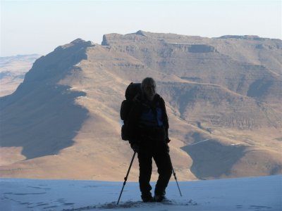
Above is a view down Icidi Pass, which shows the steepness of the slope and below a view up Icidi Pass, near the Icidi Pass Cave.
We reached the top of the pass just in time too see the sunset over Lesotho.
The view down Icidi Pass at the top of the pass.
We were elated to finally reach the top of Icidi Pass after a long, hot day, fltr Irene, Rob, Thora, Elinda and Tony, and give our weary bodies and sore feet a deserving rest.
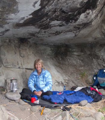
After heading down towards the stream near the top of the pass, we pitched tents as darkness descended, and enjoyed a wonderful wind free evening and clear skies, to awake the next morning to a lovely clear day.
Icidi Pass was the hardest pass that all in our group had done (none of us has done Ship's Prow), although we hadn't taken the easiest route due to lack of detailed information on this pass, and no path once the bush was encountered.
Please login or register to view the images attached to this post.
Please Log in or Create an account to join the conversation.
- tonymarshall
-
- Offline
- VE Advisory
-
- Posts: 768
- Thank you received: 2233
How many km can you go by rented bakkie?
Please Log in or Create an account to join the conversation.
- Serious tribe
-

- Offline
- Platinum Member
-

- Posts: 1056
- Thank you received: 770

And no, I also haven't been able to find a path above Jubilee Cave before.
Please Log in or Create an account to join the conversation.


Please Log in or Create an account to join the conversation.
I found Icidi a nasty steep pass with so much bundu bashing that we got badly scratched. Luckily George (Geordie) had a track on his GPS which sometimes headed straight into thick, prickly bush, it was very unpleasant! I vowed never to do it again! (famous last words)
Ship's Prow on the other hand we went up from Monk's Cowl in one day which made it extremely tough due to hiking 15km before the actual pass started. Quite a bit of bundu bashing at the bottom of the pass but nothing compared to Icidi. The really tough part came in the actual pass, the last about 1,5km of steep uphill. There was a feint path and short grass so it could have been easy going, if it wasn't for exhaustion and altitude. I have never struggled so much with lack of breath to get up that last bit.
If I had to go down this pass to compare it with Icidi, then I would say Icidi is tougher. And if I had to go up Icidi to compare it with Ships, I would also say that Icidi is the tougher one, simply because of the nasty bundu bashing and the loose scree!
The cycads were the worst!
Please login or register to view the image attached to this post.
Please Log in or Create an account to join the conversation.
Thanks for the write up.
You are braver than I am.Some of those Mnweni passes are real swines with all that summer bush.
I preferred them late winter when the bush had died back.I must be a sissy!
Please Log in or Create an account to join the conversation.

tonymarshall wrote: The photo below (taken on a previous hike from the ridge across the Mnweni river) shows Icidi Pass on the left hand side of the shadow, and the Icidi Valley almost to it's confluence with the Mnweni.
Thanks for posting the photos and the route description Tony.
That photo above has got to be the most beautiful valley in the world.
Please Log in or Create an account to join the conversation.

On the way out we took a lift to the end (over the new bridge) of the road up the Mnweni valley which was 5.8 km. We then used the path on the right (true left) side of the Mnweni River to the Icidi valley, which was a pleasant departure from the much used path on the left (true right) side. This right path was an efficient way to get to the Icidi valley, but if going further up the Mnweni valley, I would still recommend the path on the left.
On our return, we were picked up near the Mnweni River bridge where the path descends down the ridge to the road, and this lift was 4 km.
It is also possible to get a lift up the Ntonjelana valley for about 4 km.
The respective lifts cost R 20 and R 15 (per person), in our opinion good value on the way out from a time saving point of view, and on the return to avoid the slog with tired bodies along the road back to the MCC.
Please login or register to view the image attached to this post.
Please Log in or Create an account to join the conversation.
- tonymarshall
-
- Offline
- VE Advisory
-
- Posts: 768
- Thank you received: 2233
Please Log in or Create an account to join the conversation.

