
Rockeries Pass
This picture was taken towards the end of last year. Does anyone have a more exact date of when this happened?
www.vertical-endeavour.com/gallery/drakensberg/passes/242-rockfall-on-rockeries-pass.html
Take nothing but litter, leave nothing but a cleaner Drakensberg.
Please Log in or Create an account to join the conversation.

www.vertical-endeavour.com/gallery/drakensberg/passes/241-rockfall-on-rockeries-pass.html
Take nothing but litter, leave nothing but a cleaner Drakensberg.
Please Log in or Create an account to join the conversation.
This pass is one of two relatively easy ways to access the escarpment in the Mnweni area. The other pass is Ntonjelana Pass (see below) and both passes are used as dagga-smuggling routes from Lesotho to South Africa. Rockeries Pass makes it possible to see the breathtaking Mnweni Cutback in a short weekend hike. It is a good pass to use as an introduction to the Mnweni area as the path is clear and therefore navigation won’t be a problem.
Please Log in or Create an account to join the conversation.

The above rockfall still looks pretty much the same, with the trail more established around it. This pic was taken in April 2010.
www.vertical-endeavour.com/gallery/drakensberg/passes/243-rockfall-on-rockeries-pass.html
As mentioned elsewhere on the forum, we encountered a very fresh rockfall on April 6. It may have occurred on the 4th. Small tufts of grass with soil were still scattered everywhere.
www.vertical-endeavour.com/gallery/drakensberg/passes/240-rockfall-on-rockeries-pass.html
Note the streak across the centre of the pic:
www.vertical-endeavour.com/gallery/drakensberg/passes/239-rockeries-pass.html
Be alert on Rockeries Pass!
Take nothing but litter, leave nothing but a cleaner Drakensberg.
Please Log in or Create an account to join the conversation.
After getting a lift to the kraals near the end of the Ntonjelana road, we set off up the Ntonjelan’ eshonalanga valley, the eastern Ntonjelana tributary with it’s source at the top of Rockeries Pass. There is a good path the whole way from the road to the top of the pass, but with the numerous other paths criss-crossing the area, careful navigation is required if new to the area. The conventional beginning to the route follows the left (true right) side of the river before crossing the river after about 1½ km from the road; some of the group are shown at this first river crossing in the photo below, with Saddle prominent on the escarpment.
The path then follows the right (true left) side of the river for about 1 km, and this section affords fantastic views to the Rockeries, as in the photo below. The prominent, highest, peak to the right of the Rockeries is Mponjwane (also known as Rockeries Tower), an imposing free standing peak and challenging climb.
After a second river crossing, the path then follows the left (true right) side of the Ntonjelan’ eshonalanga River to the top of the pass. On the approach to the pass, several caves are passed, with Sunshine Cave across the river in the photo below.
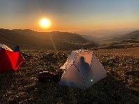
The base of the pass is usually regarded as being the junction of the stream originating from Nguza Pass with the Ntonjelan’ eshonalanga, and this confluence can be seen in the photo below. On crossing the Nguza stream, one is immediately confronted with a steep scramble up a rock slope, a man made obstacle carved out by locals to prevent donkeys from being able to use the entire Rockeries Pass route, and allowing them to get some business using their donkeys from this point to the road. Above the scramble the path curves to the top of the low ridge, and the only flat campsite in the area, Nguza campsite, is located here. Note the low level of the mist.
A view back down the bottom section of Rockeries Pass, with the path visible in the right foreground.
Soon we were in the mist, and the path zig zags up the slope, effectively flattening the gradient. Note the massive tripod on Grandeur’s (with the yellow buff) pack.
A view back down the path.
Although boulder strewn in places, the path remains easy to follow.
Please login or register to view the images attached to this post.
Please Log in or Create an account to join the conversation.
- tonymarshall
-

- Offline
- VE Advisory
-

- Posts: 768
- Thank you received: 2233
Our second day was set aside for some exploration, and being clear I decided to head some way down the pass to get some better photos, and to ascend back via the alternative gully to the top of Rockeries Pass, which I had seen several times before. (I will post on the alternative gully later.) Sabine and Hermann came part way down with me, while the photographers stayed busy on the summit. The ‘prow’ below is a major landmark on the pass, and the normal route goes to the left (heading up), and the alternative gully to the right.
A view down the lower section of the pass, with the views to Cathedral Peak and the North Peak of the Saddle.
The zig zag section of the pass.
A view down the pass with the ‘prow’ and the North Peak of the Saddle.
Sabine and Hermann on the zig zags near the top of Rockeries Pass.
Near the top of Rockeries Pass, with the Rockeries in the background. The Rockeries Pass alternative gully is just over the low ridge on the left, between the low ridge and Rockeries. The top of the pass has splendid views of Rockeries, Cathedral Peak and Bell, and the North Peak of the Saddle.
Please login or register to view the images attached to this post.
Please Log in or Create an account to join the conversation.
- tonymarshall
-
- Offline
- VE Advisory
-
- Posts: 768
- Thank you received: 2233
Please Log in or Create an account to join the conversation.
The lower section of the alternative gully, which has no path.
A view down the lower section of the alternative gully.
The alternative gully had running water right to the top, and is very similar to the main route, with lots of boulders and scree.
An easier way up out the gully on a grass slope.
Back to the scree and boulders.
The gully flattens out and becomes more grassy near the top.
View down from the top of Rockeries Pass alternative gully.
Please login or register to view the images attached to this post.
Please Log in or Create an account to join the conversation.
- tonymarshall
-
- Offline
- VE Advisory
-
- Posts: 768
- Thank you received: 2233
In April 2025 I noticed a local guy sheltering under a blue tarp about 50m above where the path crosses the gully.
In August I passed through again and went to have a closer look.
There is a small rock shelter in place behind which is another shelter with a low, corrugated iron roof.
I wondered why the structure had been built there and how long it has been in place. Is it perhaps to provide shelter for a semi-permanent guard on traffic in the pass from Lesotho? Perhaps an unofficial toll?
Please login or register to view the images attached to this post.
Please Log in or Create an account to join the conversation.

It looks like the corrugated iron sheeting is the roof of the stone walled structure that has either blown off or been removed because it was not needed to provide shelter from rain.
A permanent concrete block structure is being built near Five Star Cave for the same reason, where I assume the problem requires a more extended local presence. This is good for hikers, as hopefully Five Star Cave and Shepherds Cave will not be used for this purpose and be trashed by the local occupants. In March I saw the preparations for the structure being done, and spoke to two guys who were sitting next to the path near Shepherds Cave. They told me that they are indeed monitoring stock theft, and were staying in another nearby cave, gesturing upstream. Further along upstream I saw a new path, and deduced that they were using Shepherds Cave 2.
In my ongoing quest to visit caves in the area, I have also come across quite an elaborate structure built into an overhang overlooking the Ntonjelane valley, with a rock wall, built in hinged door, and old bed with metal bedsprings inside. When I asked about this I was told that it was once someone's home, but is now used as a lookout/guard point when necessary.
I am also aware of a permanent structure that has been built in the hills to provide shelter for local shepherds who were previously using nearby rock art sites as shelters when they needed to stay in the area to discourage them from using the rock art sites.
Please Log in or Create an account to join the conversation.
- tonymarshall
-
- Offline
- VE Advisory
-
- Posts: 768
- Thank you received: 2233
