
Mzimude Pass North
ghaznavid wrote: The passes in the area (photo by Fitness):
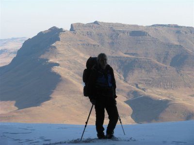
From the escarpment (from berg.co.za - site has been down for a while, fortunately I have this saved on my computer):
I believe the route just below the camera is the south south pass, the one just above the prow is the north south pass (marked south pass)
If anyone has done this pass, please post more pictures and a description.
Take nothing but litter, leave nothing but a cleaner Drakensberg.
Please Log in or Create an account to join the conversation.

There was very little information available on the North Pass, an unmarked pass on the hiking map, and I didn't know what to expect, so the afternoon before my descent I went to have a look down the pass just to be sure that it was doable and to prepare myself for the next day's descent. Just below the top section there was a steep section that I couldn't see from the top, so I went a short way down to be able to see this, and was then satisfied that the pass was indeed doable.
A shepherd has built a hut right at the top of Mzimude Pass North, and all around the top of the pass there are signs of sheep sleeping near this hut.
The view down the top of the pass, showing the short section of grass slope at the top leading quickly into the boulder bed, and lower down the steeper section that cannot be seen from the top.
A view back up the short section of grass slope at the top of Mzimude Pass North.
Just below the upper boulder bed section there is a fairly recent rockfall/landslide in the steep section of the pass.
Looking at this rockfall and the scree associated with it, it was fairly stable and I decided to continue down in the boulder bed of the pass, although it would also have been possible to exit on either the left or right grass slopes and descend these. However, the sides of the gully were steep below the rockfall, meaning once committed to the gully you can't just get out onto the grass slopes lower down, or if on the grass slopes would have to descend a lot before finding somewhere to get back into the gully.
The debris from the rockfall was deposited lower down in the gully, but was stable and quite safe to walk on.
Please login or register to view the images attached to this post.
Please Log in or Create an account to join the conversation.
- tonymarshall
-

- Offline
- VE Advisory
-

- Posts: 772
- Thank you received: 2252
Since I was heading back to Bushman's Nek, I needed to exit the pass to the south (true right) which I did near the area at the centre of the photo below before contouring around on the grass slope on the right, clockwise to the right.
If I had been going to Garden Castle, I would have continued down the stream of the pass, until reaching the Hidden Valley Path.
A view back up Mzimude Pass North from the grass slope at about 2450 m that I used to exit from the pass.
It was also necessary to cross the stream of Mzimude Pass South to continue on my planned route back to Bushman's Nek, and I had this view back up the Mzimude Passes soon after crossing the south pass stream.
It was then quite a tedious walk along the ridge, passing by the source of the stream flowing down to Wave Cave and Curtain Cave and later descending into the stream flowing past Painters Cave, before eventually joining the Giant's Cup trail path and returning to Bushman's Nek.
Please login or register to view the images attached to this post.
Please Log in or Create an account to join the conversation.
- tonymarshall
-
- Offline
- VE Advisory
-
- Posts: 772
- Thank you received: 2252
Please Log in or Create an account to join the conversation.
Please Log in or Create an account to join the conversation.
- Serious tribe
-

- Offline
- Platinum Member
-

- Posts: 1057
- Thank you received: 778
I seem to recall the Mzimude one lining up perfectly with a sandstone cliff gap as well - which is odd, seeing as a fissure is a volcanic feature. Perhaps the basalt that used to be above it eroded first, resulting in the sandstone below eroding first where the gap was. Or perhaps a fault line as ST suggests.
Please Log in or Create an account to join the conversation.

Thanks to Roger for the use of his images
Please login or register to view the images attached to this post.
Please Log in or Create an account to join the conversation.
Looks like you took a much harder line than what I used with Hobbit back in 2015. We went up the pass, following the gully till it started becoming rocky, when we exited to the left (south) and followed the grass slopes to the top. Not the easiest pass around, but you have to love how straight that line is!
Please Log in or Create an account to join the conversation.
Please Log in or Create an account to join the conversation.
And it isn't just kind-of-sort-of, if you've had enough drinks - it is so obviously a perfectly straight line! Even on Google Earth.It was also so interesting to see the line continue up past Robs Cave in the distance. Amazing!
But that's only half the story. There is another straight line like this which lines up Isicutula Pass, Walkers Gully Pass and some gaps on the slope below. And these two lines are actually perpendicular!
Tons of these in the Drakensberg, but I have never seen another two that intersect each other at a right angle like that!
Please login or register to view the images attached to this post.
Please Log in or Create an account to join the conversation.
