
Jarateng Pass North
ghaznavid wrote:
There is, but rather camp on the south side of Long Wall. There is a nice spot about 100m vertical from the top of the ridge. Giants Castle gets a massive amount of traffic and might not be safe.GerritHuman wrote: 3) Is there a nice camping spot near the top of Giants Castle?
Thanks for help Ghaz. Your info helps alot.
I agree to stay out of sight for safety.
On the map this looks like a flap spot (in red), are you referring to this? I can see to the left (in blue) there is water a bit down the mountain.
Regards
Gerrit
Please login or register to view the image attached to this post.
Please Log in or Create an account to join the conversation.
- GerritHuman
-

- Offline
- Elite Member
-

- Posts: 152
- Thank you received: 58
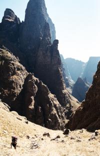
The top end of the Jarateng is long and not very steep (as opposed to the south side of the ridge, which is a killer). Once you get above the waterfall with the massive rock pool below it, the valley is full of potential camping spots, only right near the top of the ridge does this cease to be the case.
Please login or register to view the image attached to this post.
Please Log in or Create an account to join the conversation.

Please Log in or Create an account to join the conversation.
- GerritHuman
-
- Offline
- Elite Member
-
- Posts: 152
- Thank you received: 58
1. Is the path up the Middle Ridge easy to find from the valley?
2. I take it that the top of Jarateng is pretty flat, but, to confirm, can one camp there and remain completely invisible to the Lesotho side? Is this the most advisable place to camp? It seems Giant's Castle has been quiet for the past few years, but I'd rather err on the side of caution.
3. I assume that finding Langies from the south shouldn't be too hard if we keep to the escarpment ridge, go over Erskine, and look out for the Carbineer's Grave. Is this the correct route? Is there anything else I should know?
Please Log in or Create an account to join the conversation.
- TheRealDave
-
- Offline
- Elite Member
-
- Posts: 195
- Thank you received: 256
If you can find the correct ridge, then the path is easy to find, even in mist or the dark. The path dies on the final flat approach to the contour path, but by then you are in the right place and just walk across the flat grass lands. Middle Ridge is a much quicker way to get to the Jarateng Passes.
I cannot think of a campsite that will be completely invisible to the Lesotho side. Gut feeling though is that if you get to the summit late in the afternoon and then wait until dark to set up a camp high up the valley (i.e. near the top of North Jarateng pass) you will be fine.
Langies is the first major saddle north of you - you can either follow the ridge as you suggested, or the valley systems, which will probably be quicker and allow you to follow paths. There should be a good path leading to the top of Langies Pass
Please Log in or Create an account to join the conversation.
Please Log in or Create an account to join the conversation.
- TheRealDave
-
- Offline
- Elite Member
-
- Posts: 195
- Thank you received: 256
The path to the Middle Ridge is off the path to the Langalibalele Ridge at the post saying “Path Closed.” The path is very feint in the beginning but, as others have noted, becomes fairly distinct on top and can be followed all the way to the left of the penultimate hump when it peters out.
My group elected to do the traverse that Ghaznavid did, despite the fact that we’d already descended into the river-bed for water. And, like Ghaznavid, I wouldn’t recommend it: the slopes are steep and your ankles are always at an angle. But if a path were to be cut, this would the most direct route from the Middle Ridge. From the meeting point of the Jarateng passes we took the river-bed up, then started up the slopes at the appropriate point.
We were about two-thirds of the way up when a mild thunderstorm hit, in the midst of which there suddenly appeared two inquisitive Basotho dogs (though not aggressive), so we sheltered in North Jarateng Cave and ended up sleeping there, uncomfortably. You can pitch two tents in the lower parts of the cave (second tent already packed up in the photo below), but you’re on a slight slope, so you keep on sliding down, etc.
The final ascent from the cave follows an obvious line, with hints of a natural path forming here and there. One may be excused for posting yet another photo of the stunning view from the top:
There is a good, convenient trickle at the top of the pass on the true right (indicated in Tony’s photo below), though it probably dries up in winter.
As for the walk across to Langalibalele, we kept to the high ground and headed for the three cairns on the spine of Mt Erskine, which cut out a bit of the distance of following the valley round (though if one were to ascend Langalibalele and go down North Jarateng, then the gentler walk around the slopes of Erskine and up the valley might be preferable). This route also gives one an immense panaroma of the whole Giant’s Castle area from an opening between Potterill and Bond. There were many signs of Basotho activity in this area—goats, horses, cows—but no Basothos.
This may be a minor point, but after being directed to the Picnic Site and finding no showers, we were told that the showers at Giant’s Castle were closed four months ago. However, there are a few points after the security gate where the dirt road comes right down to the river, so we had a quick rinse there.
Please login or register to view the images attached to this post.
Please Log in or Create an account to join the conversation.
- TheRealDave
-
- Offline
- Elite Member
-
- Posts: 195
- Thank you received: 256
Ghaznavid and/or Intrepid (or anyone else in the know), do you have an approximate altitude for these caves? And do you have any idea whether they'll be dry in the rain, as it looks to be rainy this weekend?intrepid wrote: From what I remember it was where I have marked the red circle.
EDIT: Never mind about the altitude question: ghaznavid stated that his cave was at 2,750m.
Please Log in or Create an account to join the conversation.
- TheRealDave
-
- Offline
- Elite Member
-
- Posts: 195
- Thank you received: 256
The cave has a very low entrance and should be good shelter, and there is level sleeping area for 3 to 4 people, although more could be created by shifting a few smallish rocks. I'm unable to say if the floor will be dry or damp.
Please login or register to view the images attached to this post.
Please Log in or Create an account to join the conversation.
- tonymarshall
-

- Offline
- VE Advisory
-

- Posts: 770
- Thank you received: 2244
I ended up finding Ghaznavid's cave, as it was misty, and the cave was rather drippy and damp. There were two usable sleeping areas, neither entirely drip-free. Though it's not the most comfortable cave, the view in the morning was spectacular (it was even better at sunrise, but I was racing to capture that with my proper camera - pics to follow perhaps):
Another from further up, during a brief break in the mist:
There is a fairly distinct path all the way up the rest of the pass after this cave. I would not rate it a 3/10, but it depends on what you mean by difficulty. No, it doesn't have a rock-gully like Bannerman (I don't personally find rock-gullies like Bannerman or Corner Pass difficult), but it gets steep near the summit and it tops out quite high. That said, I am not at my fittest.
EDIT: Tony, I forgot to add that if you recorded the altitude of the cave at 2,805, then it looks like Intrepid's cave is actually above Ghaznavid's, in the final rockband before the face, and not below it, as marked in the image?
Please login or register to view the images attached to this post.
Please Log in or Create an account to join the conversation.
- TheRealDave
-
- Offline
- Elite Member
-
- Posts: 195
- Thank you received: 256
