
Uklebe Pass
23 Mar 2016 19:44 #67454
by biomech
Replied by biomech on topic Uklebe Pass
The pass is great! We had some heavy going to get into it and therefore I agree with Hobbitt, that cave is a bonus. It saved us from a very long finish to the day. We were also really lucky with the weather!
Please Log in or Create an account to join the conversation.
29 Mar 2016 15:48 - 29 Mar 2016 15:54 #67516
by biomech
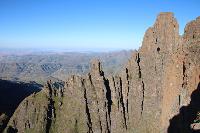
This is a picture of Uklebe Pass from the ridge across from the base of the pass.
Replied by biomech on topic Uklebe Pass
This is a picture of Uklebe Pass from the ridge across from the base of the pass.
Please login or register to view the image attached to this post.
Last edit: 29 Mar 2016 15:54 by biomech.
Please Log in or Create an account to join the conversation.
29 Mar 2016 15:56 #67517
by biomech
This is the final gully about 80m vertically from the top of the pass.
Replied by biomech on topic Uklebe Pass
This is the final gully about 80m vertically from the top of the pass.
Please login or register to view the image attached to this post.
The following user(s) said Thank You: ghaznavid
Please Log in or Create an account to join the conversation.
Yesterday 11:05 - Yesterday 11:11 #80394
by tonymarshall
Replied by tonymarshall on topic Uklebe Pass
In April I was at Lotheni for four days and did an ascent of Uklebe Pass. I hiked up the Lotheni and KaMasihlenga valleys, and overnighted in Yellowwood Cave the first night, went up most of the pass via the ridge and overnighted in Hawk Eye Cave the second night, and then completed the pass on the third day.
The preceding posts in this topic are mainly about ghaznavid’s planning to do Uklebe Pass, with very little about the pass itself. There is another topic named ‘Uklebe/Lotheni Loop: Hawks and Waterfalls’ with his well written write up of Uklebe Pass, with photos, and this was very useful for my research while preparing to do Uklebe Pass.
When we came down KaMasihlenga Pass in 2024, I intentionally used the stream way to go so that when I did Uklebe Pass I could use the ridge with the trail, and thus do both options. The photo below shows this ridge at the centre of the photo, with the KaMasihlenga river on the right of the ridge. Yellowwood Cave is in the forest at the right of the photo, and The Hawk is the peak at the top right. Uklebe Pass goes up to the left of The Hawk, and a bit further to the left is KaMasihlenga Pass. A side stream joins the KaMasihlenga river between the ridge in the left foreground, and the ridge in the centre of the photo.
I left Yellowwood Cave, heading up the right (true left) of the stream, crossed the KaMasihlena river just upstream of the junction with the side stream, and went up the ridge between the two streams. To get through the rock band on the ridge, visible in the previous photo, I followed the side stream side of the ridge, and went up a grass slope through the cliffs. The photo below shows the view back down this grass chute.
Although getting through the rock band and the initial section of the ridge are very steep, the trail on the ridge is very useful, and continues a long way along the ridge. The trail just suddenly starts/stops above the rock band, and there is no indication where animals or locals using this route pass through the rock band.
A similar view to the previous photo, with The Hawk at the right, Uklebe Pass in the shadows to the left of The Hawk, and KaMasihlenga Pass at the left of the photo below.
A view back along the ridge.
The trail continues to just below the height of the contour path, although there is no visible trace of the contour path here anymore. I continued up the ridge a bit further, and then contoured right crossing three side streams to get to the KaMasihlenga river. The contouring was on quite a side slope, and was tough on my feet. Above the river I had this view of Uklebe Pass, with KaMasihlenga Pass at the left of the photo.
I had lunch in the river at the section with the many low waterfalls, before starting up Uklebe Pass. I went up the grass slope on the right of the stream/gully in the photo below to avoid the waterfalls in the gully.
A view back down the grass slope to the KaMasihlenga river below.
Please login or register to view the images attached to this post.
Last edit: Yesterday 11:11 by tonymarshall. Reason: Correct formatting
Please Log in or Create an account to join the conversation.
- tonymarshall
-

- Offline
- VE Advisory
-

Less
More
- Posts: 770
- Thank you received: 2242
Yesterday 11:15 - Yesterday 11:20 #80395
by tonymarshall
Replied by tonymarshall on topic Uklebe Pass
A view up the grass slope. I went up to near the base of the cliffs, and then went right below the cliffs, and up between the cliffs and the gully. It was still quite early, so I could take my time and ascend slowly.
Soon I could see Hawk Eye Cave across the gully on the right (true left). I went across a narrow, exposed ledge, and crossed the gully below the chockstone obstacle and went to the cave.
As mentioned by ghaznavid, Hawk Eye Cave has many drips, and I settled in on the far side of the overhang, at the highest point of the floor, where there was only one slow drip. I had expected to have to go up to the top of the pass, or back down in the gully, to collect water, but the drips in the cave were more than enough to collect enough water with my pot, mug and bottles, and transfer it into my water bag. There was water flowing in the gully below the chockstone, but it was too shallow to collect, although I could have a wash with it.
The next morning I continued on up the pass. The chockstone obstacle, in the photo below, is in the same rock band as the cave, and I had no problem to scramble up it with my pack on, and continue up the boulder bed of the gully.
Higher up there was another obstacle, a long slab that was wet with seepage and as it was raining lightly. I bypassed this on the grass slopes on the right (true left).
Soon I could see the top of Uklebe Pass. The top section of the pass is a grass slope.
A view back down the upper section of the pass.
Just below the top of the gully, a well used path crosses the gully, and I exited the gully here to the right along this path – towards The Hawk. My summit photo of Uklebe Pass, although the light rain had stopped, it was cool so I kept my rain jacket on.
That same morning, not long after my ascent, the Walking Home project group, including Andrew P who I had got a lift to Lotheni with, descended Uklebe Pass, so the pass probably had the most people using it ever on the same day.
I traversed a short way along the escarpment, and descended an unmarked pass between The Tent and The Hawk. I call it Tent Pass, and the write up will follow soon.
Uklebe Pass is an interesting pass, and it’s taken me far too long to finally do it. I wonder if anyone else has done it in the ten years since ghaznavid’s groups ascent and write up. With this, I have now done all of the marked passes at Lotheni, and have a continuous run of all the marked passes from the Gully/Chain Ladders into Vergelegen.
I have uploaded my gps track of Uklebe Pass, and it is available for download, either from the Downloads – Drakensberg Passes section, or the gps data link in the Passes of the Central Drakensberg Index.
Please login or register to view the images attached to this post.
Last edit: Yesterday 11:20 by tonymarshall. Reason: Correct formatting
The following user(s) said Thank You: Stijn, JonWells, jamcligeo, firephish, GetaPix, Smurfatefrog, supertramp, Riaang
Please Log in or Create an account to join the conversation.
- tonymarshall
-
- Offline
- VE Advisory
-
Less
More
- Posts: 770
- Thank you received: 2242
