
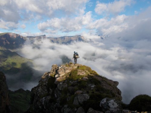
Mafadi loop - Corner Pass NHA and Leslies Pass
Please Log in or Create an account to join the conversation.


Please Log in or Create an account to join the conversation.
- Drakensbergie
-
- Offline
- Premium Member
-

- Posts: 119
- Thank you received: 78
Below are links to 3 previous threads which dealt with the topic:
Re: Mafadi
Re: Summer overnighting advice: Injasuti
Leslie’s Pass
In 1996 when I first did Leslies Pass, I remember following a terrace route which made the trip from Marble Baths fairly easy. In 2011 when I did the trip again, I went armed with some information from Stijn from this site, determined to follow the terrace route if at all possible. I managed to find the start of the route and successfully followed it till about halfway, where I seemed to end up in the river bed and ended up boulder-hopping the rest of the way. As the next day was a chill day for me, I used the time to scout the terrace route. I was fairly successful, and 2 days later on my return home, I followed the route, taking photos of landmarks and troublesome spots in order to compile a description for myself.
On 2 occasions since, I managed to follow the route both ways (with slight deviations where the path becomes vague or overgrown), and will definitely not follow the river route again.
The terrace route never once follows in or crosses the main river. It sticks to below the ridge on the escarpment side of the river. The trick when one loses the path, is to revert to as close as possible to that ridge to pick up the path again. At times the route has its own set of cairns to follow (in side streams) and at other times it is a fairly well-defined path.
I have attached a document in the downloads section, which has been compiled from my personal notes. It was useful to me in rediscovering the route on my next visit, but may not prove as useful to others, as I knew what I was expecting. I trust that it will prove useful to others too, as it is definitely a worthy alternative to the river route.
Please Log in or Create an account to join the conversation.

Please Log in or Create an account to join the conversation.
I couldn't help but notice the distances quoted for each day. The last time I did this was years before I owned a GPS, but I seem to remember the distances being not quite as long. Did you guys track each day with a GPS? Day 3 especially seems a bit excessive?
I seem to remember the entire loop being around the 45km mark.
Just curious, I don't want to head back out there again to find it's way longer than I remember!


Please Log in or Create an account to join the conversation.
Yup, my GPS was running the entire hike.Dillon wrote: I was just having another read through this report for a bit of research on the Northern High Approach for Corner Pass. Planning on giving it a go in a couple weeks time.
I couldn't help but notice the distances quoted for each day. The last time I did this was years before I owned a GPS, but I seem to remember the distances being not quite as long. Did you guys track each day with a GPS? Day 3 especially seems a bit excessive?
I seem to remember the entire loop being around the 45km mark.
Just curious, I don't want to head back out there again to find it's way longer than I remember!
After accounting for some bounced signals in Corner pass the detailed distances are below.
Day 3 also included my strolling around the escarpment, only 1.5km though
Please login or register to view the image attached to this post.
Please Log in or Create an account to join the conversation.
- Smurfatefrog
-
 Topic Author
- Offline
- Moderator
-

- Posts: 1132
- Thank you received: 1550
There are a couple of numbers there that don't quite line up with what I remember, for the sake of my legs I hope your GPS was over-reading

Please Log in or Create an account to join the conversation.
So there will be variations between routes and detours taken by different parties, that's a certainty, I am perhaps stating the obvious and not answering your question. lol.
Best prepared for 55km total trip distance.
Please Log in or Create an account to join the conversation.
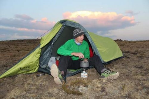
Generally speaking the GPS distances are correct. I've been testing my Fenix 2 along with my Montana to check distances against those shown on the maps, and on my last two hikes bothe GPS's showed higher numbers than those on the maps. Also, the Fenix 2 has a 3D track function (not sure about the exact terminology used thought) that literraly tracks the distance your feet moves. By example, if you move 1m forward but have to climb up 2m to get over a rock the map will show you a 1m distance, but due to the terrain you actually covered 3m (1m forward and 2m upward). Also, if you zig-zag up a pass the distance will be longer than if a straight line was taken.
To give you another example of my last hike (this past weekend at Champaign Castle), the map states the distance from the campsite to Blind Man's corner as 5,5km (If I remember correctly), both my GPS's gave the distance at around 6,67km's.
I don't believe the distances on the maps anymore, I use it sort of more as an indication of distance rather than the actual distance to be travelled. Not too much of an issue for me (although being statistically minded the incorrect data is a bit of an irritation), but when taking unfit people along on a hike (not a great idea to start with, I know) or like I did last weekend when I took my kids along the additional distance not budgeted for could prove to be problematic.
Please Log in or Create an account to join the conversation.

Were you in one of the groups we saw on Sunday? Two of us heading from carpark up Gray's on SundayRiaang wrote: To give you another example of my last hike (this past weekend at Champaign Castle), the map states the distance from the campsite to Blind Man's corner as 5,5km (If I remember correctly), both my GPS's gave the distance at around 6,67km's.
Please Log in or Create an account to join the conversation.
- Smurfatefrog
-
Topic Author
- Offline
- Moderator
-
- Posts: 1132
- Thank you received: 1550
